Showing 284 items matching " eastern park"
-
 Parks Victoria - Wilsons Promontory Lightstation
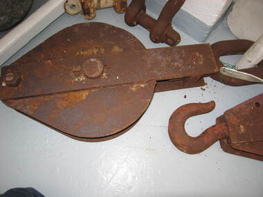
Sheave Block/Pulley
Pulleys were used to lift goods to and from boats and at other sites at the lightstation where hauling was undertaken. Historical images and text panels in the Wilsons Promontory Museum attest to the detailed logistics that needed to be exercised in lifting and transporting goods once they had arrived by boat at the Eastern Landing. Cranes and a flying fox were employed in the nineteenth century and updated versions of this equipment served well into the twentieth century. The first cranes to be employed at the site were built just after December 1857, when tenders were called to construct two cranes prior to the commencement of building the lightstation.The first boat landing at the promontory was built on the west side of the lighthouse, which the architect, Charles Maplestone sketched in June 1859, the same month that he announced the completion of the lighthouse. His drawing shows one of the cranes as a large structure built for heavy duty lifting. Soon the east landing became the preferred place for delivering stores, but as late as 1993 a crane, timber structures and disused heavy iron machinery remained at the old site.Large rusted iron pulley, large loop at one end and smaller loop at the other. No hook.(Sheave Block) -
 Parks Victoria - Wilsons Promontory Lightstation
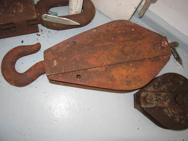
Sheave block/ pulley
Pulleys were used to lift goods to and from boats and at other sites at the lightstation where hauling was undertaken. Historical images and text panels in the Wilsons Promontory Museum attest to the detailed logistics that needed to be exercised in lifting and transporting goods once they had arrived by boat at the Eastern Landing. Cranes and a flying fox were employed in the nineteenth century and updated versions of this equipment served well into the twentieth century. The first cranes to be employed at the site were built just after December 1857, when tenders were called to construct two cranes prior to the commencement of building the lightstation.180 The first boat landing at the promontory was built on the west side of the lighthouse, which the architect, Charles Maplestone sketched in June 1859, the same month that he announced the completion of the lighthouse.His drawing shows one of the cranes as a large structure built for heavy duty lifting. Soon the east landing became the preferred place for delivering stores, but as late as 1993 a crane, timber structures and disused heavy iron machinery remained at the old site.Large iron pulley with loop at one end and hook at the other, rusted. -
 Parks Victoria - Mount Buffalo Chalet
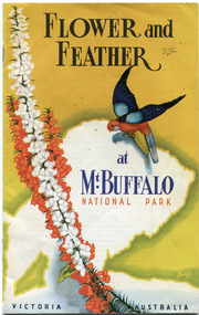
Booklet, "Flower & Feather at Mt Buffalo National Park Victoria, Australia"
H.C.E. Stewart , who first visited the plateau in 1919, produced the booklet, Flower and Feather, the Chalet has two copies. Published in the 1950's by the Victorian Railways Public Relations and Betterment Board, it is still an accepted guide on the the mountain bird's annd plants." (pg 132. Historica) The writer first visited Mt Buffalo in 1919 - & then after the war he decided to show all the unique flowers of Mt Buffalo through this book.Listed in Draft Inventory of Significant Collection Items . Appendix A.3. Natural History. (Pg 169. Historica).2 x Yellow & white books with an eastern Rosella and a red & white flower on it. 21 pages of text & photos. Front page has a picture of an Eastern Rosella and flower, the Melbourne Bay. (.2 has holes punched in it.Yes -
 Park Orchards Community House
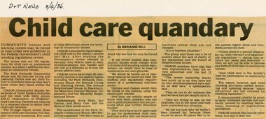
Newspaper, Child Care review at Park Orchards Community House and Donvale Living Centre. CHAOS (Community Houses Association of Outer Eastern Suburbs) and ANLC (Association of Neighbourhood Learning Centres). Doncaster and Templestowe News, 8 April 1986
-
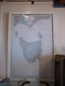 Parks Victoria - Gabo Island Lightstation
Chart, nautical, "Cape Otway to Gabo Island including Tasmania", April 1071
This mounted chart, dated 21 August 1971 is under glass in a wooden frame and covers Bass Strait between Cape Otway and Gabo Island, showing southern and eastern Victoria and the whole of Tasmania. The frame was possibly handmade locally. The charts are specific to the Gabo Island Lightstation and have second level contributory significance for their historic value and provenance to the lightstation.Blue / grey & white nautical chart of Cape Otway to Gabo Island . It is under glass and in a white painted wooden frame. The frame has three holes at the top left and the base.Top left-hand," AUS 422 DEPTHS IN FATHOMS......." -
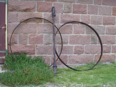 Parks Victoria - Gabo Island Lightstation
Axle and wheel rims
Rusted wheel rims and axel were recovered from scrub near the ‘Eastern Landing’ in 2002. The two large wheel rims are made of flat iron. The axel is a long metal shaft with built up sections at either end. They are possibly from a WWI, horse drawn gun carriage used to carry stores from the jetty to the lightstation. Images show the carriage in use in 1943. The items have second level contributory significance for their historic value and provenance to the lightstation. .1 & .2, Large rusted, circular, metal wheel rims. Made of flat iron. .3, Rusted metal axle. long shaft with built up sections at either end. -
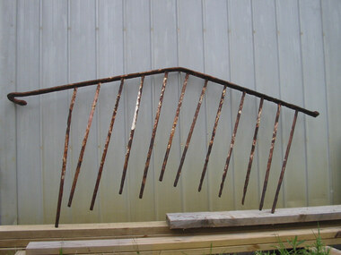 Parks Victoria - Gabo Island Lightstation
Handrail
Steel hand rail from stone steps at house 3/4 recovered from grass near "Eastern Landing" in 2000.Steel tube shaped length bent at middle and curved at one end. 12 metal dowells attached to this rail, but unattached at end. Varying lengths. Rusted with some white paint residue. -
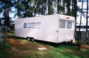 Park Orchards Community House
Photograph, Outer Eastern College caravan, Unknown year
... Park Orchards Community House 572 Park Road Park Orchards ... -
 Lakes Entrance Historical Society
Book, Land Conservation Council Victoria, Land Conservation Council East Gippsland Area Review, 1985
Report describing the physical and biological aspects of the public land in the eastern corner of Victoria, predominantly the Orbost Shire. Many issues are covered in the report, including timber industry, national parks, waterways and tourism. Six mapsparks, waterways, tourism, gippsland -
 Federation University Historical Collection
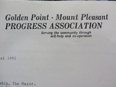
Document - Documents, Documents Relating to the Re-establishment of the Golden Point - Mt Pleasant Progress Association, 1983-1997, 1983-1997
Mara Gluyas was secretary of this organisation for 11 continuous years (1983-1994), and President Ian McKinnon was President for 9 years from 1983-1992). The inaugural 1983 committee was Ian McKinnon, Mara Gluyas, N. Strange, A. Graham, M. Davidson, M. Adams, Peter Hiscock, Ian Blomeley. The Association was concerned with the advancement of the Ballarat area in general and to promote Golden Point - Mt Pleasant area in particular. Small box with purple lid filled with the constitution, minutes associated with the Golden Point - Mt Pleasant Progress Association, and lists of members.mara glouyas, ian mckinnon, sovereign hill, pearce's park rotunda, elms, tree planting, sovereign hill lookout reserve, christmas carols, mine collapse, former golden point direction indicator, signage, norm strange, golden mount historical mines direction indicator, yarrowee creek tree planting committee, peady street, pearce street, barry davis, nerrina tip, ballarat observatory, carols by candlelight, yarrowee park project, magpie street bbq park, neighbourhood watch, magpie street park, cobden street, pryor street bus shelter, hill street, urban wildlife corridor, south street bluestone gutter, eastern baths site, grant street, street lighting, magpie street, letterhead, aboriginal advancement league, golden point primary school, sunnyside woollen mill, ballarat west goldfields, fred hunt, kerry daniell, craig ford, jack colin greville, jack colin greville plaque at mt pleasant lookout, golden point school oval -
 Bacchus Marsh & District Historical Society
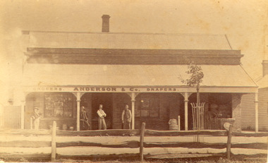
Photograph, Anderson's Store, Main Street, Bacchus Marsh circa 1870s-1890s
This store in Main Street Bacchus Marsh was first opened by James Young in November 1866. In October 1869 it was purchased by William Anderson and was operated by members of the Anderson family until 1971. The site of the store was on the southern side of Main Street on the eastern side of Eddie Toole Park. On the opposite side of the street was the site of the former Post Office on the northern side of Main Street. The store was first named the Border Mills Store during James Young's ownership and was later known as the Border Store (Anderson & Co.).Small black and white photograph showing Anderson’s store. It shows a large stone building with a corrugated iron verandah which bears a painted sign of the name of the business: GROCERS. ANDERSON & Co. DRAPERS. Behind a brick parapet rises a hip roof with one chimney visible. Four men stand in casual poses ranged along the verandah. A post and rail fence runs along the road frontage. A tree is planted in an ornamental wrought iron plant protector on the inside of the fence.On the back in decorative print: “ New York Photographic Adelaide Travelling Brand Chas. F. Husband Manager.” In handwriting: Border store built by James Young 1866 owned by Anderson 1869-1972. BMDHS stamp and no. HS 411.shops bacchus marsh vic., anderson's store bacchus marsh, stevenson and mcnicoll 1883 photographs of bacchus marsh and district -
 Lakes Entrance Historical Society
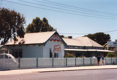
Photograph - Skippers Restaurant, 1999c
Original home of George Carpenter, son of John Carpenter, first contractor for the artificial entrance. On this site home and office of Carpenter's Caravan Park.Colour photograph of Skippers Restaurant, Esplanade. It shows a weatherboard building, centre roof connects eastern hipped roof and western gable which is half timbered in Tudor style. Decorative corbels support eaves. Wrought iron lacework and brackets under veranda roof. Lakes Entrance Victoriaarchitecture, township, restaurant -
 Lakes Entrance Historical Society
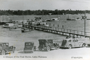
Photograph - Boat Harbour, 1935c
Black and white photograph of the eastern wing of the western Boat Harbour. It shows small vessels and launches moored at jetties. People on jetties and seated on shore. Four motor cars parked at the edge of the lake in foreground. Lakes Entrance VictoriaA Glimpse of the Boat Haven, Lakes Entrancejetties, boats and boating, waterfront, transport -
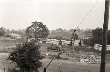 Eltham District Historical Society Inc
Photograph, Sherbourne Road, Para Road and Simms Road at Briar Hill, 3 November 1967, 3 Nov 1967
Viewed from eastern side of Para Road opposite Graham Body Works.. Simms Road is running to the right in front of the old house. The house belongs to Mrs Cameron whose daughter married a DAVEY after which Davey Street is named. Excavation work is being undertaken for the realignment of the Para Road and Sherbourne Road intersection where the current roundabout is located, approximately where the two cars are parked. Mrs Cameron's house and the other are where Montmorency Secondary College is situated. The school opened in 1969.Roll of 35mm black and white negative film, 6 strips Ilford HP3briar hill, cameron, davey, davey road, graham body works, greensborough, montmorency secondary college, sherbourne road, simms road, vw service -
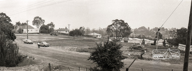 Eltham District Historical Society Inc
Photograph, Sherbourne Road, Para Road and Simms Road at Briar Hill, 3 November 1967, 3 Nov 1967
Viewed from eastern side of Para Road opposite Graham Body Works.. Simms Road is running to the right in front of the old house. The house belongs to Mrs Cameron whose daughter married a DAVEY after which Davey Street is named. Excavation work is being undertaken for the realignment of the Para Road and Sherbourne Road intersection where the current roundabout is located, approximately where the two cars are parked. Mrs Cameron's house and the other are where Montmorency Secondary College is situated. The school opened in 1969.Photostitch from multiple images on roll of film. Roll of 35mm black and white negative film, 6 strips Ilford HP3briar hill, cameron, davey, davey road, graham body works, greensborough, montmorency secondary college, sherbourne road, simms road, vw service -
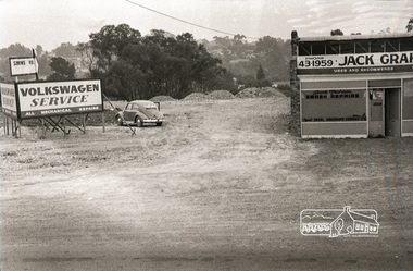 Eltham District Historical Society Inc
Photograph, Sherbourne Road, Para Road and Simms Road at Briar Hill, 3 November 1967, 3 Nov 1967
Viewed from eastern side of Para Road opposite Graham Body Works.. Simms Road is running to the right in front of the old house. The house belongs to Mrs Cameron whose daughter married a DAVEY after which Davey Street is named. Excavation work is being undertaken for the realignment of the Para Road and Sherbourne Road intersection where the current roundabout is located, approximately where the two cars are parked. Mrs Cameron's house and the other are where Montmorency Secondary College is situated. The school opened in 1969.Roll of 35mm black and white negative film, 6 strips Ilford HP3briar hill, cameron, davey, davey road, graham body works, greensborough, montmorency secondary college, sherbourne road, simms road, vw beetle, vw service -
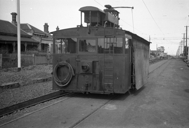
 Ballarat Tramway Museum
Photograph - Set of 4 - Tram 671 on tour in Melbourne, Travis Jeffrey, 13/4/1996
Set of four photos of W4 class tram No. 671, running a BTM tour in conjunction with the Rail Tourist Association on 13/4/1996 - see item 8033. Photos by Travis Jeffrey. 1 - Tram at South Melbourne Depot 2 - In Collins St Melbourne. 3 - In Victoria Parade with the original Eastern Hill fire station in the background. 4 - In Royal Park.Yields information about the use of BTM Tram No. 671 for a tour in Melbourne.Set of four colour prints with photographers notes on rear.In ink on rear "M28/21 and 41396"btps, w4 class, tram 671, btm, tours, collins st, south melbourne depot, royal park, victoria parade -
 Melbourne Tram Museum
Negative - Set of 2, Wal Jack, 17/05/1942 12:00:00 AM
Set of two Black and white negatives, by Wal Jack, of rail grinder No. 2 parked in Ascot Vale Road, Moonee Ponds during the construction of the connecting line between Moonee Ponds and Union St and Maribyrnong Road corner. The west line has been completed and the eastern line is under construction. Photo dated 17-5-1942 in the Wal Jack album along with details of the location and the tramcar.trams, tramways, trackwork, new tramway, work trams, ascot vale road, moonee ponds, grinder, tram 2 -
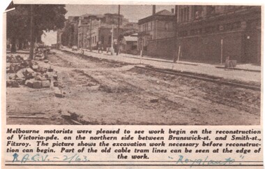 Melbourne Tram Museum
Newspaper, Royal Automobile club of Victoria (RACv), removal of the cable tram track in Victoria Parade, 1963 to 1971
Set of 8 newspaper clippings, mid 1960's concerning traffic control and congestion issues. .1 - Royal auto - 2/1963 - reporting on the removal of the cable tram track in Victoria Parade between Brunswick and Smith St, noting the old cable tram lines. .2 - Royal auto - 1/65 - Photo of Toorak Road Toorak with a tram and parked cars. .3 - Royal auto - 8/64 on Chapel St with W2 324 (route 77, City) showing the impact of parked cars at 8.45am and a motor car trying to squeeze past. .4 - Royal auto - 9/64, Burke Road Camberwell, showing the impact of parked cars and trams. Photo includes SW6 934 (Route 7 Camberwell) .5 - Royal auto - 8/67 - Swanston St near Collins St. .6 - View of Toorak Road, Hartwell, W2 641 (Spencer St, route 74) photo 8/68 by John Shingler. shows the shopping centre. .7 - Royal auto - 9/64 - Johnston St Collingwood and buses. .8 - MMBW Living City Winter 1971 of Kew Junction, peak hour inbound noting the new Eastern Freeway will reduce congestion.Extensive notes on the rear of the photo, see image i2trams, tramways, congestion, traffic control, racv, chapel st, toorak road, victoria parade, cable trams, w2 class, sw6 class, burke road, camberwell, route 77, route 7, swanston st, kew junction, route 74, hartwell, johnston st, buses, tram 324, tram 641, tram 934 -
 Melbourne Tram Museum
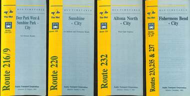
Ephemera - Timetable - bus - The Met - set of 24, The Met, 1992 & 1993
SSet of 24 The Met bus timetables, with diagrammatic map, major stops and contact details. All dated during1993 unless noted otherwise. 1 - Route 216/9 - Deer Park West & Sunshine Park - City 2 - Route 220 - Sunshine - City - 1992 3 - Route 232 - Altona North - City - 1992 4 - Route 233 - Fishermens Bend - City - 1992 5 - Route 254 - Northland Shopping Centre - City - 1992 6 - Route 256 - La Trobe Uni - City - 1992 7 - Routes 258 & 259 - Northland Shopping Centre, and La Trobe Uni - City via Eastern Freeway - 1992 8 - Route 260 etc - Deep Creek Templestow - Donvale - City 9 - Route 264 - Mitcham, Donvale City 10 - Route 265 - Deep Creek - City 11 - Route 602 - Brighton - city 12 - Route 269, 291 and 296 - Greensborough, Heidelberg & Newmans Road to Box Hill 13 - Route 272 - Warrandyte - City 14 - Route 276 & 278 - Warrandyte - City 15 - Route 284 & 270 - East Kew - City or Box Hill 16 - Route 285 - The Pines - Box Hill 17 - Route 286 & 288 - The Pines and Templestowe - Box Hill 18 - Route 290 - North Nunawading - Box Hill 19 - Route 292 etc - Box Hill, Deep Creek, Ringwood, Warrandyte 20 - Route 301, 281 315 - Ringwood, Park Orchards and Donvale - City 21 - Route 305 - Box Hill - Ringwood 22 - Route 366 & 367 - Ringwood - Croydon 23 - Route 600 - St Kilda - Brighton Beach - 1992 24 - Route 601 - Gardenvale - City - 1992Yields information about some of The Met bus services 1993Set of 24 The Met timetables, DL size, printed in two colours.timetables, the met, route 216, route 220, route 232, route 233, route 254, route 258, route 259, route 260, route 264, route 265, route 256, route 602, route 269, route 272, route 276, route 284, route 270, route 285, route 286, route 288, route 290, route 292, route 301, route 305, route 366, route 367, route 600, route 601 -
 Melbourne Tram Museum
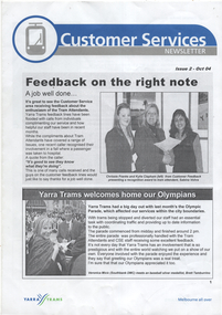
Newsletter - Set of 2, Yarra Trams, Customer Services, 2004
... ), Neil Mitchell 3AW, Revenue Protection, Luna Park, Essendon... 3AW, Revenue Protection, Luna Park, Essendon depot, Eastern ...Two issues of a short-lived newsletter issued by Yarra Trams in 2004, to its Tram Attendants, giving staff feedback, tram priority program (Clarendon St South Melbourne hook turns), Neil Mitchell 3AW, Revenue Protection, Luna Park, Essendon depot, Eastern Road Operations Centre, tickets, RMIT Bundoora RMIT Travel Pass and personal notes.Yields information about the tram attendants and revenue protection officers.Set of two four A4 page newsletters part colour.tramways, operations, newsletter, tram attendants, revenue protection, luna park, eroc -
 Lakes Entrance Historical Society
Photograph - Lakes Entrance, Bulmer H D, Whiters Camp Park, 1940c
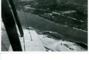
Black and white copy photograph of aerial view of eastern approach, showing Princes Highway, Whiter's Camp Park, sandy outer barrier beside Cunninghame Arm, distant view of North Arm. Lakes Entrance Victoriawaterways, township -
 Eltham District Historical Society Inc
Photograph, Looking north across the Fitzsimons Lane Bridge over Yarra River between Eltham and Templestowe, c.1985, 1985c
Turnoff to Candlebark Park on right. The bridge over the Yarra River was initially opened September 22nd, 1961. Newspaper reports at the time of opening stated it linked Bolton Street, Eltham, with Fitzsimons Lane, Templestowe. In 1955 the Country Roads Board (CRB) produced survey plans that showed proposed land acquisition for the future bridge and road approaches. The 1955 plan shows that it was proposed to connect Fitzsimons Lane with Bolton Street in Eltham by a diagonal road across the river. The road connection would then continue along Bolton Street to Main Road. Prior to construction of the bridge the CRB modified the proposal significantly so that there was a new road parallel with Bolton Street and then curving to join Main Road at what was then its intersection with Old Eltham Road. This involved significantly more land acquisition and altered the pattern of land subdivision through this corridor. Initially the new road was just a single two-way carriageway as it would have required a significant widening of the cutting on the Shire of Eltham side of the river. The road was officially un-named but was known locally as the Eltham-Templestowe Road. The 1966 Melway street directory and other 1960s editions also listed the road as the Eltham-Templestowe Road. In December 1970, Eltham Shire Council, in pursuance of the provisions of the Local Government Act, named it Templestowe Road. The road was renamed Fitzsimons Lane around 1984 in conformity with the section south of the river. In 1991 a new bridge was built to the west of the original bridge. Fitzsimons Lane was widened to four traffic lanes although on the Eltham side this was done within the limits of the existing cutting. NEW BRIDGE STARTS THEM EXPLORING Without any fanfares, Country Roads Board workmen on Friday afternoon put the finishing touches to the approaches, removed the barricades, and let the traffic roll over the new Yarra bridge linking Bolton Street, Eltham, with Fitzsimons Lane, Templestowe. Over the week-end many “bridge watchers” who were making one of their periodic inspections of the progress on the new bridge found to their surprise that they could drive over it, so that people who had gone for a run out to Eltham suddenly found themselves wandering through Templestowe and Doncaster. By Monday the word of the bridge’s opening had got around sufficiently for many regular travellers to the city from Eltham and beyond to vary the monotony by going to town via Templestowe and Kew instead of through Heidelberg. They were surprised at the distances – about 3 ½ miles from Eltham to Templestowe, 6 miles from Eltham Shire hall to the Lower Heidelberg Road-Banksia Street intersection. NEW NEIGHBOURS For people on both sides of the river, the new bridge has turned distant friends into near neighbours. A Greensborough man on Sunday took 35 minutes to reach the home of a friend in East Doncaster, but the return trip over the new bridge took only 17 minutes. It will be some time yet before most people work out the possibilities in shorter and quicker trips form the north-eastern areas to the eastern and south-eastern suburbs. The coming of the warmer months will soon teach many, though the short cuts to Peninsular beaches and eastern suburban drive-ins. And before very long it is likely there will be a Tramways bus running from Templestowe to Eltham station. NEW BRIDGE STARTS THEM EXPLORING (1961, September 27). The Diamond Valley News (News clipping held in SEA_74-1_047) The previously un-named road between Main Road and Yarra River, Eltham South, east of Bolton Street was named Templestowe Road, December 15, 1970 NAMING OF STREETS AND ROADS. (1970, December 15). The Diamond Valley News (News clipping held in SEA_74-2_022)Colour photographinfrastructure, shire of eltham infrastructure, bridge, fitzsimons lane bridge, yarra river, candlebark park, red nose day -
 Kew Historical Society Inc
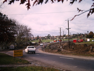
Photograph - Construction of the Eastern Freeway (F19), Ron Setford, March 1972
... locations. Ron Setford Eastern Freeway F19 Freeway Willsmere Park ...Ron Setford and his wife Grace Setford lived in Tanner Avenue, East Kew, from c.1946 to c.1995. A keen photographer, he recorded the changing face of Kew over a 20 year period. Apart from 30 photographs of built structures and places in Kew dating from 1960 and 1961, 145 of his 35mm colour slides chronicle the development of the F19 (later renamed Eastern) Freeway through the Yarra Valley in Kew over a five year period from c.1972 to c.1977. This important collection was donated to the Society by his granddaughter in 2025.This collection of 175 35mm slides is of local and statewide significance, owing to its subject matter, particularly the major development of road transport infrastructure during the 1970s with the construction of the Eastern Freeway. The photographer also took care to annotate and date most of his slides which enable the researcher to pinpoint temporal and spatial locations.Kilby Rd, Willsmere Park on left"Eastern Freeway / Kilby Road / Nov 72"ron setford, eastern freeway, f19 freeway, willsmere park, kilby road -
 Kew Historical Society Inc
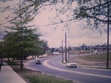
Photograph - Construction of the Eastern Freeway (F19), Ron Setford, March 1972
Ron Setford and his wife Grace Setford lived in Tanner Avenue, East Kew, from c.1946 to c.1995. A keen photographer, he recorded the changing face of Kew over a 20 year period. Apart from 30 photographs of built structures and places in Kew dating from 1960 and 1961, 145 of his 35mm colour slides chronicle the development of the F19 (later renamed Eastern) Freeway through the Yarra Valley in Kew over a five year period from c.1972 to c.1977. This important collection was donated to the Society by his granddaughter in 2025.This collection of 175 35mm slides is of local and statewide significance, owing to its subject matter, particularly the major development of road transport infrastructure during the 1970s with the construction of the Eastern Freeway. The photographer also took care to annotate and date most of his slides which enable the researcher to pinpoint temporal and spatial locations. Kilby Rd, Willsmere Park on left Kilby Rd, Willsmere Park on left" E Freeway Nov 1972"ron setford, eastern freeway, f19 freeway, willsmere park, kilby road -
 Kew Historical Society Inc
Photograph - Construction of the Eastern Freeway (F19), Ron Setford, March 1972
Ron Setford and his wife Grace Setford lived in Tanner Avenue, East Kew, from c.1946 to c.1995. A keen photographer, he recorded the changing face of Kew over a 20 year period. Apart from 30 photographs of built structures and places in Kew dating from 1960 and 1961, 145 of his 35mm colour slides chronicle the development of the F19 (later renamed Eastern) Freeway through the Yarra Valley in Kew over a five year period from c.1972 to c.1977. This important collection was donated to the Society by his granddaughter in 2025.This collection of 175 35mm slides is of local and statewide significance, owing to its subject matter, particularly the major development of road transport infrastructure during the 1970s with the construction of the Eastern Freeway. The photographer also took care to annotate and date most of his slides which enable the researcher to pinpoint temporal and spatial locations."Eastern Freeway 6/72 / Willsmere Park flood underpass"ron setford, eastern freeway, f19 freeway -
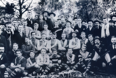 Whitehorse Historical Society Inc.
Photograph, Mitcham Football Club, 1904
The Mitcham Football Club was established in 1888. Known as the 'Tigers', their colours are black and yellow and their home ground is at Walker Park, Mitcham. Originally the club played on the Reporter and District League where they won premierships in 1904, 1905, 1914, 1915 and 1921, then in the Eastern Suburbs Football League they won a premiership in 1947. At present (2015) they compete in the Eastern Football League and filed senior, reserves, under 19's and 6 junior Teams.Black and white photograph of the Mitcham Football team and supporters taken outside in1904.Mitcham F.C Premises is written on the bottom of photographmitcham football club, sporting clubs, football clubs -
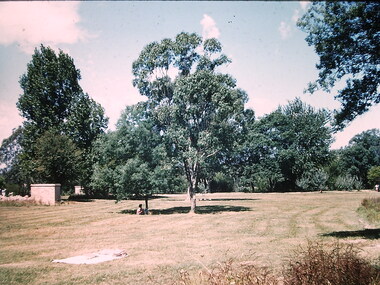 Kew Historical Society Inc
Photograph - Willsmere Park, Ron Setford, 1960
Ron Setford and his wife Grace Setford lived in Tanner Avenue, East Kew, from c.1946 to c.1995. A keen photographer, he recorded the changing face of Kew over a 20 year period. Apart from 30 photographs of built structures and places in Kew dating from 1960 and 1961, 145 of his 35mm colour slides chronicle the development of the Eastern Freeway through the Yarra Valley over a five year period from c.1972 to c.1977. This important collection was donated to the Society by his granddaughter in 2025.This collection of 175 35mm slides is of local and statewide significance, owing to its subject matter, particularly the major development of road transport infrastructure during the 1970s with the construction of the Eastern Freeway. The photographer also took care to annotate and date most of his slides which enable the researcher to pinpoint temporal and spatial locations.Nilron setford, photographs -- kew (vic.) -- 1960s, willsmere park -
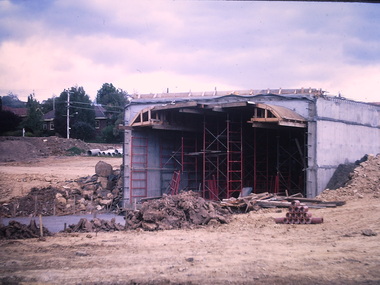
![Photograph - Construction of the F19 [Eastern Freeway], Ron Setford, May 1976](/media/collectors/550653872162f11fb04854aa/items/682882fe64071e7c58e68c40/item-media/6828832464071e7c58e68e02/item-fit-380x285.jpg) Kew Historical Society Inc
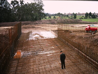
Kew Historical Society IncPhotograph - Construction of the F19 [Eastern Freeway], Ron Setford, May 1976
Ron Setford and his wife Grace Setford lived in Tanner Avenue, East Kew, from c.1946 to c.1995. A keen photographer, he recorded the changing face of Kew over a 20 year period. Apart from 30 photographs of built structures and places in Kew dating from 1960 and 1961, 145 of his 35mm colour slides chronicle the development of the F19 (later renamed Eastern) Freeway through the Yarra Valley in Kew over a five year period from c.1972 to c.1977. This important collection was donated to the Society by his granddaughter in 2025.This collection of 175 35mm slides is of local and statewide significance, owing to its subject matter, particularly the major development of road transport infrastructure during the 1970s with the construction of the Eastern Freeway. The photographer also took care to annotate and date most of his slides which enable the researcher to pinpoint temporal and spatial locations."Regrading Willsmere Park"ron setford, eastern freeway, f19 freeway -
 Kew Historical Society Inc
Photograph - Construction of the Eastern Freeway (F19), Ron Setford, November 1972
Ron Setford and his wife Grace Setford lived in Tanner Avenue, East Kew, from c.1946 to c.1995. A keen photographer, he recorded the changing face of Kew over a 20 year period. Apart from 30 photographs of built structures and places in Kew dating from 1960 and 1961, 145 of his 35mm colour slides chronicle the development of the F19 (later renamed Eastern) Freeway through the Yarra Valley in Kew over a five year period from c.1972 to c.1977. This important collection was donated to the Society by his granddaughter in 2025.This collection of 175 35mm slides is of local and statewide significance, owing to its subject matter, particularly the major development of road transport infrastructure during the 1970s with the construction of the Eastern Freeway. The photographer also took care to annotate and date most of his slides which enable the researcher to pinpoint temporal and spatial locations."Willsmere Park underpass / Macdougal of Ireland contractors"ron setford, eastern freeway, f19 freeway