Showing 811 items
matching maps and sections
-
 Melbourne Tram Museum
Ephemera - Timetable/s, Melbourne & Metropolitan Tramways Board (MMTB), "MMTB bus Timetables", 1970
Set of two bus timetables for specific routes, day of week giving information on tram times at specific time points, route map, sections and fares and organisation address - 616 Little Collins St. Melbourne. 1 - East Kew - Box Hill - Doncaster - May 1970 - no route numbers given. 2 - Fishermen's Bend - City via three different routes - August 1970 Yields information about two MMTB 1970 bus routes.Set of 2 MMTB Tram timetables, folded sheets, 10 sections on white paper.trams, tramways, mmtb, timetables, melbourne, fares, east kew, doncaster, fishermen's bend -
 Bendigo Historical Society Inc.
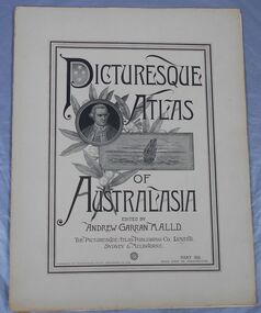
Journal - Picturesque Atlas of Australasia
The Picturesque Atlas of Australasia was released in 42 supplements between 1886 and 1889 and attracted over 50,000 subscribers. Produced by the Picturesque Atlas Publishing Company in Wynyard Square, Sydney. The company was established in 1885. Edited by Andrew Garran. For detailed information search the website of the National Library of Australia. Thirty-three parts. Volume 9 to Volume 42. Volumes 1 - 8 and 28 are missing. Light tan coloured covers have a printed central rectangular double border. The title and publication information and illustrations are printed inside the border. The illustrations included are Captain Cook, a sailing ship and a sprig of wattle. The pages include many black and white illustrations. Volume 16 Separate map of Fiji. This Volume covers Bendigo as one of Victoria's country towns Volume 27 Includes separate Railway, Postal and telegraph map of Queensland. Volume 42 This last Volume contains a Miscellaneous section at the back with an Editorial Postscript and two maps - Australia and The Solar System.australasia, flora and fauna, subscription, history, exploration -
 Warrnambool and District Historical Society Inc.
Letter Book 4, 1901, 1908
This letter book has letters, invoices, sketch maps and plans and dates from 1908 to 1910. It came from the office of John William Crawley Junior, an engineer, architect and surveyor in private practice in Warrnambool and also the official engineer of the Shire of Warrnambool from 1895 to 1935. His father, brother and son were also engineers and worked in that capacity or as the Shire Secretary for the Shire of Warrnambool, with the Crawley family members recording a total of 132 years of service to the Shire. The letter book was passed on to John Crawley’s son, Rolf, Engineer for the Shire of Warrnambool from 1935 to 1968. The letter book then came into the possession of Michael Hand who took over the private surveying business of Rolf Crawley in Warrnambool and the Warrnambool and District Historical Society has acquired the letter book, one of several Crawley ledgers, from the Michael Hand estate. This letter book is of considerable significance as it contains maps, plans, sketches and written information on the work of John William Crawley, the engineer for the Shire of Warrnambool for 40 years. This is a black-covered letter book with copies of letters and field maps and plans and an alphabetical listing at the front. Some of the letters are invoices for work carried out. The leather section of the front cover has been almost completely torn away and the binding is mended with adhesive tape. There are some torn pages. The front page has a signature and a mauve stamp. ‘Letter Book’ ‘J.Wm. Crawley (Private)’ ‘ Rolf L. Crawley, Civil Engineer, Drainage and Water Supply Engineer, Licensed Surveyor, Registered Architect, Warrnambool’ ‘4’ rolf crawley, warrnambool, john william crawley, junior, warrnambool, history of warrnambool -
 Bendigo Military Museum
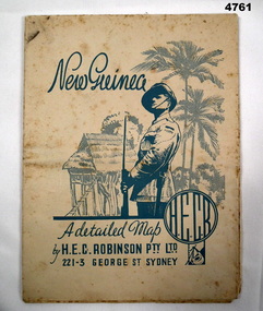
Map - MAP, NEW GUINEA, H.E.C Robinson PTY LTD, Post WW2
... Maps ...Map Robinsons “Territory of New Guinea and Papua” 0ff white colour rectangular shape, shows New Guinea, Papua, New Britain, New Ireland & Bougainville, colours red, orange, yellow, green designating boundaries, when folded one section has in blue a depiction of An Australian Soldier with palm trees & native hut.“Map No 315”maps, new guinea, robinsons -
 Bendigo Historical Society Inc.
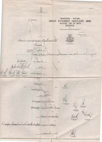
Map - STRUGNELL COLLECTION: HUSTLER'S LINE OF REEFS, BENDIGO, September 1913
Map, Hustler's Line of Reefs, Great Extended Hustler's Mine, Bendigo, Transverse Section. Plate No. X11 (12). Bulletin No 33 Signed H.A.Whitelaw Underground survey Office Bendigo September 1913 Drawing shows mine shaft to over 3454 feet deep and appears to show samples of connecting horizontal shafts with their respective mineral contentsUnderground Survey Office, Bendigo.map, bendigo, great extended hustler's mine -
 Bendigo Historical Society Inc.
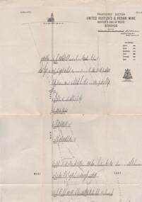
Map - STRUGNELL COLLECTION: UNITED HUSTLER'S & REDAN MINE, September 1913
Map, United Hustler's & Redan Mine, Transverse Section, Hustler's Line of Reefs, Bendigo. Plate No. XX1X (29).Bulletin No 33 Signed H.A.Whitelaw. Drawing shows the vertical shaft descending to over 1805 feet and appears to show samples of connecting horizontal shafts with their respective mineral contents. One level shows respective water levels .Underground Survey Officemap, bendigo, hustler's & redan mine -
 National Vietnam Veterans Museum (NVVM)
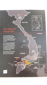
Map, New Zealand's Vietnam's War
On a black background is the story of New Zealand's Vietnam War from June 1964 to December 1972. It details the number of soldiers who served and the number of soldiers who lost their life and were wounded. Surrounding the wall map there is a description of the 10 areas where New Zealand Solders were based. They are listed below in the keywords section.map, new zealand, bong son, qui nhon, dong ba thin, bien hoa, nui dat, vung tau, saigon, thu dau mot, chi lang, phuoc tuy province -
 Ballarat Tramway Museum
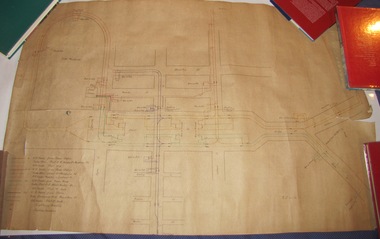
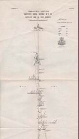
Drawing, Electric Supply Co. of Vic (ESCo), Tramway Power supply arrangements 1914, Jan. 2014
Yields information about the electrical power supply and overhead switching for Ballarat in 1914.Rolled drawing showing Tramway Power supply arrangements 1914, track map, power station, feeder cable, switches, section insulators, box locations, lightning arrestors and feeder cables for the various routes in Ballarat. Dated 2/1/1914, with initials GL. The various cables and trolley wire has been drawing in differing colours.ballarat, power station, overhead, section insulators -
 Ballarat Tramway Museum
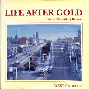
Book, Weston Bate, "Life after Gold - Twenthieth-Century Ballarat", 1993
Details the history of Ballarat following the 19th century gold discoveries and how Ballarat changed its industry and social life in particular after the 1st and 2nd world wars and the change of Government policies in respect of trade and social welfare.Book - 240 pages + end papers + hard covers + dust jacket titled "Life after Gold - Twenthieth-Century Ballarat" Dust jacket printed in colour, sewn sections, end papers glued to cover. Has table contents, list of illustrations, list of maps, acknowledgements, table of conversions, an index, appendices, abbreviations, notes, bibliography. non-fictionDetails the history of Ballarat following the 19th century gold discoveries and how Ballarat changed its industry and social life in particular after the 1st and 2nd world wars and the change of Government policies in respect of trade and social welfare.ballarat, local history, 20th century social history, social history -
 Bendigo Historical Society Inc.
Map - COMET MINE - TRANSVERSE SECTION COMET MINE
Transverse section of the Comet Mine on the Hustler's Line of Reef Bulletin No 33, Plate No XXV signed by H. A. Whitdon, Underground Survey Office Bendigo September,1913. Map shows depth of the different levels, the type of stone and shaft about 2020 deep. A number of smaller drawings on the side. Reference explaining the different types of stone, etc. Geological Survey of Victoriamining, hustler's line of reefs, transverse section of comet mine bulletin no 33 plate no xxv, lightning hill line of reef -
 Melbourne Tram Museum
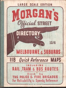
Book, The Met, "Morgan's Official Street Directory - Melbourne and Suburbs", c1951
... Maps ...Book - 5 sections, sewn with green cloth spine binding, card covers, 188 pages, 118 maps, titled "Morgans Official Street Directory - Melbourne and Suburbs" Has many advertisements around edges of the maps. Shows the Latrobe St line (opened 1/1951), but not the Bourke St tram line. Price 12/6. Published by Val Morgan and Sons of 64 Elizabeth St Melbourne. A web search for similar directories - Museum of Victoria - https://collections.museumsvictoria.com.au/items/1217271 gives background to the directory.trams, tramways, maps, melbourne, street directory -
 Melbourne Tram Museum
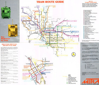
Pamphlet, Melbourne & Metropolitan Tramways Board (MMTB), "See Melbourne by Tram", early 1980's
Fold out pamphlet - 10 sections, titled ""See Melbourne by Tram" providing a detailed tram map of Melbourne, key tourist locations marked on map. Notes that Travelcard Zone 1 can be purchased for all locations. Published by the MMTB early 1980's. Trading name used on pamphlet is "METRA". On inside has sketches and advertisements for some tourist locations and restaurants. Notes which routes were replaced by buses on Sundays. Second copy added 13/1/2017 from Donation of John Prideaux.trams, tramways, map, mmtb, metra -
 Stawell Historical Society Inc
Map - Drawings, Wendy Jacobs, Western Highway Community Precinct Development Structural Drawings, 2014
501 Slab and Footing Plan. 502 Slab and Footing Details. 505 Roof Framing Plan 506 Steel Framing Elevations - Sheet 1. 507 Steel Framing Elevations and Sections - Sheet 2 508 Steel Framing Details - Sheet 1 509 Steel Framing Details - Sheet 2 SN1 General Notes, Site map & Drawing Index Used in building Historical Society Building Eight (8) A1 Printed plans Structural DrwaingsWendy Jacobs Architect & Heritage consultant may 2014 -
 Melbourne Tram Museum
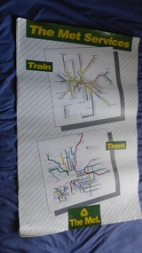
Poster, The Met, "The Met Services", mid 1990's
Poster - full colour on semi gloss paper titled "The Met Services" showing in a diagrammatic form the Melbourne tram and rail routes. For the tram section, (similar to Reg Item 509), shows major street names, route numbers, principal suburbs, terminal names, central area (pre Docklands, post light rail to St Kilda and Port Melbourne) and ticket zones. The rail map section shows the Neighbourhood ticket zones, the rail line via Altona (the direct route is not shown) and shows the St Kilda and Port Melbourne light rail lines. Has The Met logo and the Public Transport Corporation names on the bottom. Mid 1990's, Batman Ave still shown. See also Reg Items 696 and 696 for maps of the time.trams, tramways, melbourne, tramways, tram routes, railways, map, posters, tickets, neighbourhood tickets -
 Bendigo Historical Society Inc.
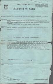
Document - H. A. & S. R. WILKINSON COLLECTION: CONTRACT OF SALE
Contract of sale dated 14th December, 1959 between Messrs. K. R. & K. S. Johnson (vendor) and Mr. T. E. Turner (purchaser). Solicitor for vendor: Hyett, Willis & Hyett, Bull Street, Bendigo. Solicitor for purchaser: Tatchell, Dunlop, Smalley & Balmer, Williamson Street, Bendigo. Property 189-191 Mitchell Street, Bendigo, being land coloured red on the map in the margin of the title part of Crown allotment 8 section 51C, being land described in certificate f title volume 6511 folio 146, together with right of carriage way over the ponds coloured brown on the said map, and together with a right to use land coloured yellow on the said map for party wall purposes together with the use of the wall which was on the 11thOctober, 1905 standing on the said land coloured yellow. Price undisclosed. Attached: business card Hillier Parker, 6 hand written notes and drawing, 1 statement pursuant to section 34 of the estate agents act 1956, 1 cover note from the united insurance company, 2 copies of engagement or appointment in writing pursuant to section 33 of the estate agents act, 1956.organization, business, h.a. & s.r wilkinson real estate -
University of Melbourne, Burnley Campus Archives
Book, Orchard, 1955-1959
No. 01310H Norman Bros. Pty. Ltd. 60-62 Elizabeth St., Melbourneorchard, field station, history, fruit tree blocks, planting plans, newspaper cutting, red delicious apple, preston prolific fig -
Tarnagulla History Archive
Set of Maps (Mining & Local Area), various
David Gordon Collection. A set of mining documents, maps and plans: 1. Dunolly Deep Leads - showing location and names of deep lead gold deposits in region around Dunolly including at Tarnagulla and Newbridge. Geological Survey of Victoria, Department of Minerals and Energy. Bulletin No. 62, Map No. 4 Dunolly (770 x 485 mm). 2. Poseidon Lead (Facsimile) 3. Nick O Time Lead (Facsimile) 4. Happy Go Lucky Mine prospectus and plan (colour copy) 5. Jones Creek GM Co. (Raven & Gourlay's) Waanyarra - Prospectus (colour copy) 6. Poseidon Area Plan (colour copy) and Poseidon Area map (B&W copy). 7. Cross-section diagram of Spread Eagle Reef 8. New Birthday Gold Mine - area map (colour copy) and mine cross-section ( (colour copy). 9. Cross section of Poverty Reef, by Department of Mines (B&W copy, 2 parts on A2 paper) 10. Time-Lease Graph for Watts Reef, Specimen Reef, Stony Reef, Poverty Reef (second page in detail), created by Eric WIlkinson for Ref Mining NL, 1995 11. 1859 Plan of the Gold Workings & Township of Sandy Creek, Shewing the Mining Leases, Extended Claims & Machinery by R.J. McMillan, Mining Surveyor (B&W copy) 12. Longitundinal and Transverse Vertical Sections of Poverty Reef, Sandy Creek 1859, by R.J. McMillan, Mining Surveyor (B&W copy) 13. Tarnagulla Locality Plan (B&W copy) 14. Universal Grid Reference Map (Topographic) for Laanecoorie North (2 copies) 15. Universal Grid Reference Map (Topographic) for Inglewood South 16. Poverty Reef, Plan showing shafts and early tenements, created by Eric WIlkinson for Ref Mining NL, 1995 17. Locality Map of mining leases in Tarnagulla 18. Plan and Elevation of part of Poverty Reef, Sandy Creek, showing the claims and positions of the shaft. by R.J. McMillan, Mining Surveyor (Facsimile, composed of taped together components) 19.Plan and Elevation of part of Poverty Reef, Sandy Creek, showing the claims and positions of the shaft. by R.J. McMillan, Mining Surveyor (Facsimile, composed of taped together components) -
 Mt Dandenong & District Historical Society Inc.
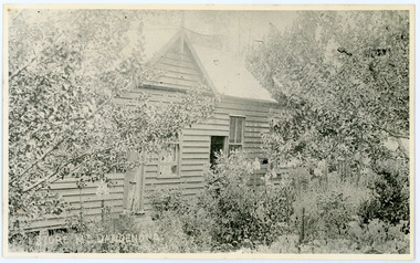
Photograph, Home and Shop of Edward Joseph Price
John Lundy-Clarke grew up in the Kalorama/Mt Dandenong area and later in life (1972-74) began to write a comprehensive history of the district working from an original settlement map in an effort to cover all areas. Edward Joseph Price was the first settler to take up a lot (Lot 1, Section 1) in the Village Settlement. He built a slab hut and brought up his family in 1896. This photograph shows a newer home built in 1908. It had a section used as a shop and also had a large room built that was to be used for public gatherings. Health department regulations led to this being impossible. The house faced Ridge Road.Black and white close up photograph showing a building made from wooden boards with trees in the front. Reverse of photograph has handwritten description by John Lundy-Clarke.On Front STORE MT DANDENONG On Reverse Home and Shop of Edward Joseph Price LOT 1 SECT 1 erected in 1908 on site of earlier dwelling from which goods had been sold without a special room for shop. In picture the room on the extreme left was bedroom for boys Charlie and Ted (Edward John). Under the gable was a large room planned for public use but never used owing to Health Department Regulations. The narrow door (open) and window were the shop which was the district’s first newsagency. Window behind leaves at right was the kitchen. 1908-1912. Gabled portion is now part of home “Mirra Laken” 1975edward joseph price, store, shop -
 Bacchus Marsh & District Historical Society
Map, Plan of the property of Messers Atkins and Clarke to be sold at the Mansion, Bacchus Marsh 19th April 1856. Copy 1
This plan of land allotments for sale indicates the property once owned by the Bacchus family in and around the township area of Bacchus Marsh. The Bacchus family sold their property in Bacchus Marsh to John Atkins and Robert Nalder Clarke in March 1851. Atkins and Clarke kept the property for a number of years until April 1856 when these allotments were put up for sale.This plan is almost identical to another copy held by the Bacchus Marsh and District Historical Society, VC Record 452, BMDHS collection). This plan, VC Record 707 Copy 1, contains a little more detail overall than VC Record 452 Copy 2, such as who did the survey work for the plan (R.C. Bagot) and who the selling agents were, (W.M. Tennent), and on the right side of the plan near the Lerderderg River is indicated the general area for a second parcel of land from this sale which is to be sold. There is also a compass illustration indicating north and south compass points.This is a very early land sales plan for the township of Bacchus Marsh and it therefore provides some clues as to how the early urban development of the township took place. Upon seeing the map in 1911 Bacchus Marsh Express newspaper editor Christopher Crisp wrote "The sale appears to have created the present township, which had a nucleus in earlier times further east", Express, 30 September, 1911, page 3.A single page paper plan showing allotments of land for sale. The subdivided land shown was owned by John Atkins and Robert Nalder Clarke, but previously owned by the Bacchus Family and was in and around their Manor House (Mansion) property in Bacchus Marsh.There are 5 portions of land further divided into numerous small portions. The land for sale is bounded by the present day streets of Main Street, Young Street, McFarland Street, Morton Streets, Crook Street, and part of the eastern section extends to the Lerderderg River. Scale: 8 chains to 1 inch The plan is pasted into a bound volume containing 76 maps or plans in total. BMDHS Loc: AR/B12/S4 Bacchus Marsh Township and Nearby Districts Maps Volume In-house Digital copies: BMDHS, Computer Network: Maps\Bacchus Marsh Township and Nearby Districts Maps VolumeHeading: Plan of the first portion of land. The property of Messers Atkins and Clarke situate at Bacchus Marsh. To be sold by W.M. Tennent & Co. at the Mansion on the Ground on Saturday the 19th April 1856. Below heading: Jas Ferguson, Lithographer On upper right side: Subdivided by R.C. Bagot London and Liverpool Chambers, Melbourne. 'Thos Taubman'. Post Office Stamp: BACCHUS MARSH VICTORIA MY 6, 63bacchus marsh victoria maps, bacchus family, land sales, manor house bacchus marsh -
 Warrnambool and District Historical Society Inc.
Book, Warrnambool Botanic Garden Masterplan, February 1995
This Warrnambool Botanic Gardens Study and Report was funded by the National Estate Grants Program of the Australian Heritage Commission and the City of Warrnambool. It was monitored in progress by a Steering Committee consisting of representatives of the Botanic and Public Gardens Advisory Committee, the Warrnambool City Council, Friends of the Warrnambool Botanic Gardens and National Estate Grants Program representatives and community representatives. The Warrnambool Botanic Gardens were first sited close to the Hopkins River in 1859. In 1869 the gardens were relocated to the present day location in Botanic Road. This plan is of some importance as it gives an overview of the history and current condition in 1995 of the Warrnambool Botanic Gardens and draws up a plan for its future development. It is useful for research and for consideration by the City Council today of policy making and further development of the gardens. This is a publication containing a master plan for the Warrnambool Botanic Gardens. It has a section on acknowledgements, a summary, eight chapters, and 14 appendices. The pages are bound with plastic rings, the front cover is plasticized with an aerial photograph of the Botanic Gardens and surrounds and the back cover is lightweight cardboard. The pages contain printed material, fold out maps, sketches and diagrams and many photocopied photographs.Front Cover: City of Warrnambool, Warrnambool Botanic Gardens, Conservation and Development Plan, Jill Orr-Young, Patrick Mallon, SF Consultants Pty Ltd, February 1995. warrnambool botanic gardens, warrnambool -
 Federation University Historical Collection
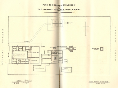
Booklet, Charles Boyd, The School of Mines Ballaarat Annual Report, 1882, 1882
The School of Mines Ballaarat Annual Report 24 January 1882, Additional Examination Statute, Certificates Granted by Council, Copy of letter received from the Honble. Francis Ormond MLC, Extracts from Visitors' Book, Fees, Form of Bequest, Life Governors, Museum open to Visitors, Office Bearers, Paper of Particulars, Report of the Curator of the Museum and Library (with plans), Report of the Superintendent of Laboratories, Report of the Lecturer in Telegraphy, Report of the Lecturer in Mechanical Engineering, Statement of Receipts and Expenditure for the year 1881, Subjects and Lecturers, Subjects and Examiners, Subscriptions and Donations from 1 January to 31 December 1881, The Lignite Deposit at Skipton (with Section and Plan)Ballarat School of Mines Annual Report. Pale brown booklet of 64 pages. A plan of the Ballarat School of Mines shows the position of the Botanical Gardens, and the Ballarat School of Mines Museum. Geological Sketch Map of Country in the Neighbourhood of Skipton and Plan showing site of Coal Discovery. Skipton Coal Discovery - Section of Windlass Shaft. .2) is a leatherbound copyballarat school of mines, coal, plan, ballarat school of mines botanical gardens, ballarat school of mines museum, museum, annual report, james oddie, w. p. bechervaise, s. e. friggis, f. j. martell, w. h. nicholls,, e. i. rosenblum, h. r. caselli, thomas mann, theos. williams, f. m. krause, alf. mica smith, walter d. campbell, w. h. shaw, charles kent, andw. berry, robert adam, wm. lant carpenter, henry parkinson, h. b. de la poer wall, w. h. brockenshire, arthur parker, c. davies, simon richards, c. r. blackett, david jones, wilberforce dyke, kr. r. krauel, duncan love, william ralph heaton, edward dowling, octavius vaughan morgan, william denton, e. h. grimwade, james hunter, the honble. francis ormond, ferdinand krause, a.a. buley, j. cosmo newberry, w.c. kernot, john lewis, j.m. bickett, james bickett, fees, annie barnett, annette budden, isabel clinton, john dimsey, agnes pobjoy, charlotte shaw, bernard o'dowd, bernard patrick o'dowd, josiah wasley, ferdinand von mueller, william kernot, john lynch, william henderson, henry richards caselli, w.p. berchervaise, e.i. rosenblum, w.h. nicholls, lignate, samuel figgis, mary drury, w. longley, botanical reserve, botanical gardens, francis ormond, george russell, william foster stawell, w.j. clarke, rivett henry bland, john warrington rogers, j. lonie, s.e. figgis, r.f. hudson, w. robertson, e.l. rosenblum, theophilus williams, andrew berry, henry sutton, h. rosales, state school classes, calcutta international exhibition, examinations, h.b.m ship bounty, certicates, walter charles kernot, william tunbridge, mary skelton, cartherine moran, mary rose usher, margaret ellen brophy, william burbridge, andrea tuxen, elizabeth curnow, francis campigi, james s. morrison, arthur hogue -
 Bendigo Historical Society Inc.
Map - STRUGNELL COLLECTION: HUSTLER'S LINE OF REEF, BENDIGO, September 1913
Map, Hustler's Line of Reef, Hustler's Royal Reserve No. 2 Co, Bendigo,Transverse Section, Plate No.V11 (7). Bulletin No 33 Signed H.A.Whitelaw Underground survey Office Bendigo September 1913 Drawing shows mine shaft to over 1640 feet deep and appears to show samples of connecting horizontal shafts with their respective mineral contentsUnderground Survey Office, Bendigo.map, bendigo, hustler's royal reserve no. 2 mine* -
 Bendigo Historical Society Inc.
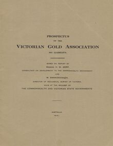
Document - MCCOLL, RANKIN AND STANISTREET COLLECTION: VICTORIAN GOLD ASSOCIATION, 1931
Prospectus of the Victorian Gold Association N.L. Based on a report by Messrs H. W. Gepp Consultant on Development to the Commonwealth Government and W. Baragwanath, Director of the Geological Survey of Victoria. Dated 1931 This company was formed to investigate the Deborah Mine, The Central Nell Gwynne Mine and the Monument Hill Mine. 12 pages including maps and Transverse Sections of the MinesThe Commonwealth and Victorian State Governments. E. Whitehead & Co., Pty., Ltd Printers 21 Equitale Place, Melbourne, C1.gold, mining, prospectus, bendigo, gold mines, victorian gold associatian, deborah mine, central nell gwynne mine, monument hill mine. -
 Warrnambool and District Historical Society Inc.
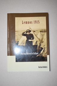
Book, Press Here, Ocean Grove, Lemnos 1915, 2011
This book, written by Katrina Hedditch, gives details of the lives and work of the 130 Australian nurses on the island of Lemnos in World War One in 1915. A number of these nurses were from the Western District of Victoria and among those was Sister Hope Weatherhead. Ellen Hope Weatherhead was born in Allansford and her parents were Henry and Ellen Weatherhead. She trained at the Melbourne Hospital and some of her experiences on Lemnos are recounted in this book. This book will be of considerable interest to those researchers and others interested in the work of Western District nurses during World War One.This is a soft cover book of 195 pages. It has a cover with a cream and brown background and a black and white photograph on the front cover and a map and printed material on the back cover. The printing on the front is white, black and brown. The book has an introduction, four sections of printed material, an appendix, acknowledgements, abbreviations, bibliography and an index. The pages contain several black and white photographs.western victorian nurses in world war one, sr hope weatherhead, warrnambool -
 Ballarat Tramway Museum
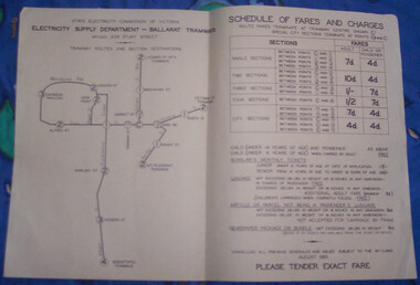
Poster, State Electricity Commission of Victoria (SECV), "Schedule of Fares and Charges - August 1965"
... Sections ...Demonstrates the way the SEC advised passengers in Ballarat and Bendigo how the fare and charges systems worked and yielded information about the fare charges in force at the time. A copy was provided in each tram behind framed glass.Dyeline print of a drawing showing Ballarat Tramway (SEC) Fares, Charges, and Section Map. Also gives charges for Scholar's Monthly tickets, Luggage, Parcels, Newspapers and Chartered trams. Dated August 1965. All fares in shillings and pence. Titled - "Schedule of Fares and Charges - August 1965". Three Additional copies added 2/1/2020 trams, tramways, ballarat, fares, sections, map -
 Bendigo Historical Society Inc.
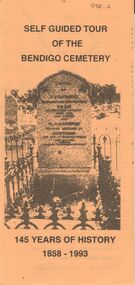
Document - BENDIGO CEMETERIES COLLECTION: SELF GUIDED TOUR BENDIGO CEMETERY DOCUMENT
BHS CollectionYellow trifold document: Self Guided tour of the Bendigo Cemetery, 145 Years of History 1858 - 1993. Document contains a map of a section of the Bendigo Cemetery, 29 graves are numbered and described. E.g. J.C.T. Ballerstedt, Quartz Reefer, Robert Clark 8 hour day pioneer, Giuseppe Favaloro restaurateur. Hitching rail outside cemetery gates is noted.bendigo, cemetery, bendigo cemetery tour -
 Melbourne Tram Museum
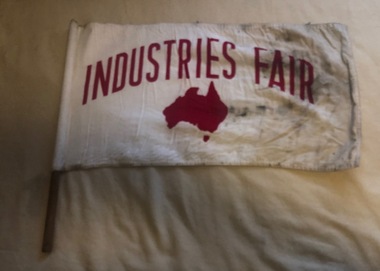
Flag, "Industries Fair", c1990
Flag advertising the Industry Fair, red print on white background with a map of Australia, printed on both sides, mounted on wooden dowel for use on Melbourne tramcars. Flag made from two layers of cotton, sewn edges, sewn into a white cotton circular section with an cloth cap and then slipped over the dowel and held in position with a single tack. No manufacturers label.trams, tramways, flags, melbourne, events -
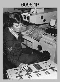 Bendigo Military Museum
Photograph - Army Survey Regiment – Map Production, Fortuna, Bendigo, c1980s
These five photographs of map production and the car park area were taken at Fortuna, Bendigo, c1980s. The first three photographs were taken in Air Survey Squadron, where aerotriangulation and digital photogrammetric extraction of topographic features from aerial photography were undertaken. Photo .4P was taken in Cartographic Squadron’s Correcting Section, located in the Attic. The technicians were probably involved in a rapid response map production, as they all were wearing field uniforms. The Army Survey Regiment’s Duty Room, RAP and Carpark appear in Photo .5P. It was probably taken from the top steps near the SGT’s accommodation block in 1986. Photos .4P and .5P are also published with item 6395.17P.This is a set of five photograph of Map Production and car park, at the Army Survey Regiment, Fortuna, Bendigo, c1980s. The photographs were printed on photographic paper and is part of the Army Survey Regiment’s Collection. Photograph .1P was scanned at 200 dpi. The others were scanned at 300 dpi. .1) - Photo, black & white, c1980s: CPL Marrianne (Van De Zee) De Groot measuring aerial photographs with a stecometer. .2) - Photo, colour, c1980s: Two unidentified technicians assessing a flight line diagram. .3) - Photo, black & white, c1980s: SPR Scheryl Delforce digitising map features on an AUTOMAP 1 Graticon table. .4) - Photo, black & white, 1986: L to R: CPL Andy Lucas, SPR Chris Gordon, unidentified, SPR Jan (Crighton) Minchin, SPR Robin Marshall, CPL Frank Downie, SPR Gayle Humphrey, unidentified technicians in the Attic, Fortuna. .5) - Photo, black & white, 1986: Army Survey Regiment Duty Room, RAP and Carpark at Fortuna. .1P - Annotated on back ‘Maryanne Degroot’ .2P, .4P to .5P – no annotation .3P - Annotated on back ‘Scheryl Delforce’royal australian survey corps, rasvy, army survey regiment, army svy regt, fortuna, asr, air survey, carto, aerotrig -
Glen Eira Historical Society
Book - GLEN EIRA GUIDE
This file contains one item: 1/A copy of the 1999 edition of the Glen Eira guide. This magazine aims to provide readers with useful information for living and working within the City of Glen Eira. It is divided into five principal sections. The first section, titled Glen Eira City Council Information, provides information pertaining to the local government. It includes information about Council meetings, the names and contact details of the six members of the Council, information about services offered by the Glen Eira Service Centre, the contact details for particular services offered by the Glen Eira City Council, information about rates and valuations, information about the building permit application process, information about waste management, and federal and state electoral maps. The second section, titled Council and Community Resource Guide, consists of a list of the various local community facilities and organizations. The third section, titled City of Glen Eira Safe Food Guide, consists of a list of food venues nominated by the Glen Eira City Council Environmental Health Services Department for their commendable level of hygiene. The fourth section, titled City of Glen Eira Business Development Unit, provides information about the eponymous local government department, which is aimed at providing aid to local businesses. The fifth and final section, titled ‘Think Local, BUY LOCAL’ Guide, consists of a list of local businesses, grouped according to industry, to try and encourage the support thereof.glen eira, city of glen eira, glen eira city council, local government, local officials and employees, kennedy norman cr, mayors, public utilities, community services, local government departments, rates, local government, building permits, waste disposal, community groups, cultural structures and establishments, law and order, libraries, education, educational and research establishments, religious groups, clubs and associations, community centres, food, restaurants, businesses -
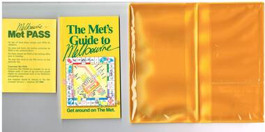 Melbourne Tram Museum
Book, The Met, "Met Pass", late 1980's
Yellow plastic folder titled "Melbourne Met Pass", with The Met logo in green print on both sides of the outside of the folder. On the inside has two pockets for storing items formed with clear plastic. Map Folded Map of Melbourne Rail and Tram lines, titled "The Met PASS Map to Melbourne" Tram Map - probably soon after conversion of the St Kilda and Port Melbourne lines to Light Rail, though these are not shown. Opened November 1987. Rail Map - shows Route 96 north section as Light Rail, co-ordinated bus routes, and the Altona line as going to Werribee. This route was opened in 1985. Date of Map c1988/1990. Has details of Museums, Art Galleries, Shopping, Gardens and Sports Arenas in Japanese. Sheet of paper advising users on presentation of the Met Pass (not included in the folder) Book - titled "The Met's Guide to Melbourne", sub titled - Get around on The Met. Card covers, perfect bound, 100 pages in colour with maps, guides and information about various locations within Greater Melbourne including Werribee Zoo and Healesville. See also Reg Item 106 to 108 for a similar item and 983 for the document that was used to launch the Met Pass. Two copies held.trams, tramways, the met, melbourne, tickets, tourist tickets