Showing 389 items matching " pine trees"
-
 Bendigo Historical Society Inc.
Administrative record - National Trust Collection: Leigh Lodge, 12 Bannerman Street (formerly Selb Villa), 1973
... Included in the garden is a Pine Tree reputed to be as old as the house itself. ...Included in the garden is a Pine Tree reputed to be as old as the house itself. ...Leigh Lodge (formerly Selb Villa) Bendigo, 12 Bannerman St. Bendigo.National Trust Collection: Leigh Lodge, 12 Bannerman Street, Bendigo 3222 A - 15 December 1973, letter from Central Victoria Branch National Trust of Australia, Victoria to J. Barton Esq. that the property at 12 Bannerman Street has received Classification No. 3049, which states: LEIGH LODGE 12 Bannerman St Bendigo. Built approx. 1871-2 according to Municipal Rate Books. Previously named Selb Villa. Stands in half acre with stone stable and coach house, with hay loft, with right of way to Harrison Street. Garden has bricked paths and terraced rock walls of local sand stone. Included in the garden is a Pine Tree reputed to be as old as the house itself. Within the house are original marble fireplaces, moulded cornices and ornamental plaster centre ceiling ornaments. The official Classification was dated May 1968. 3222 B - copy of the classification of Leigh Lodge (as Above), on yellow paper, and handwritten comments. 3222 B handwritten comments on the undated copy of the NT classificationhistoric building -
 Orbost & District Historical Society
Photograph - Photos of Orbost, W S Vogt, 1900-1920
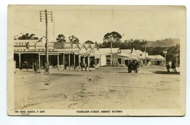
... There are several horses and carts in the building's yard. 2712.4 An oval shaped photograph showing a large group of school children on the right and a number of adults on the left who appear to be speaking to the children. A pine tree in the centre behind, and buildings also behind a fence. 2712.5 A streetscape with a telegraph pole in the left foreground and a group of shop buildings leading down a slope in the centre of the photograph. ...There are several horses and carts in the building's yard. 2712.4 An oval shaped photograph showing a large group of school children on the right and a number of adults on the left who appear to be speaking to the children. A pine tree in the centre behind, and buildings also behind a fence. 2712.5 A streetscape with a telegraph pole in the left foreground and a group of shop buildings leading down a slope in the centre of the photograph. ...These five b/w photos of Orbost were taken in the early 20th Century. 2712.1 is of Ruskin Street looking east from Nicholson Street with the Post Office on the corner. The Orbost Shire Council chambers is also shown. 2712.2 is an excellent photograph of the Post Office on the corner of Nicholson and Ruskin Streets. 2712.3 is a photograph of the first butter factory, built 1893 in Lochiel Street. 2712.4 shows a visit by the Governor of Victoria c.1920s. 2712.5 is a photo looking looking down Nicholson Street from the Ruskin Street corner. It shows a line of shops which were amongst the earliest in Orbost. These photographs are significant because they are a record of early Orbost. Five b/w photos/postcards of Orbost. 2712.1 People standing in a street; a building on the right, also buildings on the left. Telegraph pole on left hand side. 2712.2 Two horses and carts, a man riding a horse, dog in foreground. They are all in front of an elaborate wooden building (the Orbost) Post Office, and on the right hand side background is another building with the words L Herbert Snowy River Stores. 2712.3 A large wooden two-storey building behind a wooden post and rail fence. The building has several gables. A man with an apron is visible in the doorway of the top storey. There are several horses and carts in the building's yard. 2712.4 An oval shaped photograph showing a large group of school children on the right and a number of adults on the left who appear to be speaking to the children. A pine tree in the centre behind, and buildings also behind a fence. 2712.5 A streetscape with a telegraph pole in the left foreground and a group of shop buildings leading down a slope in the centre of the photograph. Several people standing around, and horses and carts. 2712.1 On front: Orbost, East Gippsland. Stanley Vogt, Bairnsdale 2712.2 On front: Orbost, Post Office. W S Vogt, Bairnsdale 2712.3 On front: Butter Factory, Orbost 2712.4 On front: added in ink is THE GOVERNOR'S VISIT TO ORBOST 2712.5 On front: Nicholson Street, Orbost, Victoria Rose Series P2397orbost, butter factory, post office, governor's visit -
 Blackburn Cricket Club
1930s Blackburn Cricket Club team
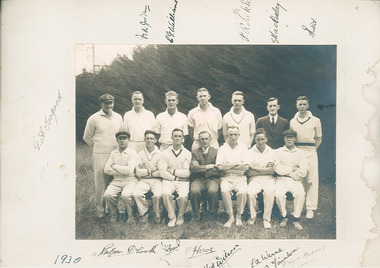
... The picture is taken at the northern end of the oval with the pine trees along the railway line in the background. ...The picture is taken at the northern end of the oval with the pine trees along the railway line in the background. ...Picture of a 1930 Blackburn CC team. The picture is taken at the northern end of the oval with the pine trees along the railway line in the background. Twelve players and two other gentlemen in full suits are pictured and there appears to be a mix of young and middle aged men. Two players (front row third from right and second row far right) appear to be wearing the same jumper in full sleeve and vest form respectively while two other players are wearing similar jumpers and another two wearing plain versions. The caps being worn by two gentlemen appear to be identical. Thirteen original signatures and the year are signed on the paper mat to which the picture is glued. The signatures appear to be signed using a fountain pen however another name (David Murray) appears to have been added using a pencil at a later date. Some of the signatures include D Cook, H.M Wilson, G.A Jorgood, C.G Williams, Rliekle, S Mackinlay and L.A Warne. Les Warne played in the 1st XI at Blackburn from 1930 to 1955 and was the captain of the 1938-39 premiership winning team. Les recieved a life membership in 1953. -
 University of Melbourne, Burnley Campus Archives
Photograph - Sepia print, A.E. Bennett, Entrance Gates, 1894-1990
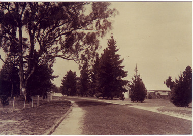
... ...pine tree avenue...I have seen a plan which showed an attractive avenue of trees (pine) from the western end of the property (where the Stockman's Cottage was later sited.)"...I have seen a plan which showed an attractive avenue of trees (pine) from the western end of the property (where the Stockman's Cottage was later sited.)" entrance gates prize essays alfred e. bennett curator's residence pavilion stockman's cottage pine tree avenue 2 copies sepia photograph. ...Note by E.B. Littlejohn, "Is the roadway the original Swan Street? Entrance gates to Gardens in the distance. Roadway leading to the Pavilion hidden behind the trees. No elms showing along the roadway," and by T.H. Kneen, "The roadway appears to terminate at the gates outside the Curator's Residence, sweeping past the Pavilion on the right. I have seen a plan which showed an attractive avenue of trees (pine) from the western end of the property (where the Stockman's Cottage was later sited.)" 2 copies sepia photograph. Copy of sepia photograph of the roadway to the Entrance Gates and Curator's Cottage seen in the distance, with the Pavilion on the right, in, "Prize Essays," Alfred E. Bennett, c.1894, after p 116. Pinus radiata avenue on each side of the road.entrance gates, prize essays, alfred e. bennett, curator's residence, pavilion, stockman's cottage, pine tree avenue -
 Williamstown Botanic Gardens- Hobsons Bay City Council
Postcard - Williamstown Botanic Gardens, c1900 - 1920
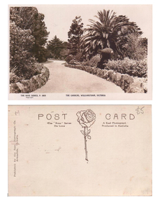
... There is a cannon on the right hand side of the card beneath a spreading palm tree. There is a tall pine and a cypress tree in the background. ...There is a cannon on the right hand side of the card beneath a spreading palm tree. There is a tall pine and a cypress tree in the background. ...The original postcards in this series (2013.002 to 2013.018) were generously loaned to Williamstown Botanic Gardens by a private collector for copying. The postcards are evidence of the interest the gardens held as a subject for postcard publishers. The text and images provide a snapshot into fashions, social interests and concerns of the time. The professionally produced images provide a pictorial history of Gardens including changing planting styles, various structures and features of the Gardens eg the aviary, cannons, the fountain, the second Curator’s Lodge and gates. The images offer an opportunity to compare garden vistas with the present day. This postcard is evidence of the location of one of the cannons relocated from Fort Gellibrand in 1906. They were removed from the Gardens in the 1960s. These same cannons remain a feature on the Williamstown waterfront in 2013. A sepia postcard depicting a winding path lined with rocks. There is a cannon on the right hand side of the card beneath a spreading palm tree. There is a tall pine and a cypress tree in the background. The cannons were relocated from Fort Gellibrand to the Gardens in 1906. Front: ‘THE ROSE SERIES, P. 1030 THE GARDENS, WILLIMASTOWN, VICTOORIA / copyright’. Reverse: Left side vertical ‘Published by the Rose Stereograph Co. / Armadale, Victoria’. Across the top of the card: ‘POST CARD / The “Rose” Series A Real Photograph / De Luxe Produced in Australia’. There is an image of a rose and stem with three leaves in the centre of the card. In pencil on top right hand corner: $5 [believed to be inserted by the vendor of the card]postcard, gardens, post-card, williamstown-botanic-gardens, hobsons-bay-city-council, garden-path, cannon, rose stereograph, rose-series, 1906 -
 Stawell Historical Society Inc
Photograph, “The Sycamores” Driveway entrance Gates
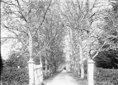
... Osmand's "Sycamores" was in a secluded block of the eastern side of the creek along which was planted pine and cypress trees. He built a comfortable house and line the carriage way with Sycamores. ...Osmand's "Sycamores" was in a secluded block of the eastern side of the creek along which was planted pine and cypress trees. He built a comfortable house and line the carriage way with Sycamores. ...Entrance gates to “The Sycamores” Driveway. A show place on Concongella from mid 1860's. "The Sychmores" where William Osmand lived. Osmand's "Sycamores" was in a secluded block of the eastern side of the creek along which was planted pine and cypress trees. He built a comfortable house and line the carriage way with Sycamores. Osmand was on the of the men who made money in the Stawell reefs mines. "The Sycamores" has been owned by the West family since c 1920. Black & white photograph (2 copies) of an entrance gateway with an avenue of deciduous trees.concongella -
 Kiewa Valley Historical Society
Photographs - Mt Beauty, Tawonga South and Falls Creek
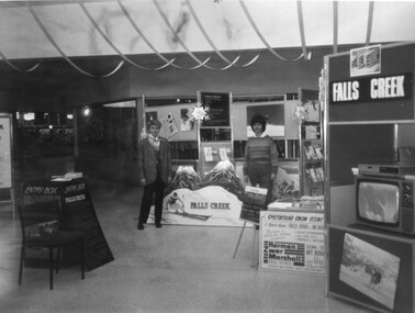
... Tawonga District Hospital/Mt Beauty Hospital before the Nursing Home - removing pine trees 18. Water Board Installation at Tawonga South (outside Rookes house) 19. ...Tawonga District Hospital/Mt Beauty Hospital before the Nursing Home - removing pine trees 18. Water Board Installation at Tawonga South (outside Rookes house) 19. ...Mt Beauty and Tawonga South are in the Kiewa Valley Mt Beauty and Tawonga are in the Kiewa Valley. Many of these photos record people who lived in these towns and their activities.Collection of black and white photos of Mt Beauty and Tawonga. Most are labelled (and some include names but no dates) in pencil on the back.Varying sizes. 1. Marketing Falls Creek 2. Driver Education Car Presentation- Mt Beauty Secondary College 3. Start of Mt Beauty Marathon 4. Mount Beauty Paramedical Day Care Centre 5. Falls Creek - Original Halley's Comet 6. Falls Creek - Original Snow-making on Twin Towers 7. Group of 10 girls 8. Mt Beauty Primary School - Tidy Towns Competition 9.Mt Beauty Primary School 10. Start of Mt Beauty Marathon 11. Lou Leiberman - Local Member 12. Bank Manager, Commonwealth Bank on left. 13. Driver Education Car - Mt Beauty Secondary College 14. Original Snow-making on Twin Towers at Falls Creek 15. Two girls 16. Mt Beauty - Home Improvement Centre 17. Tawonga District Hospital/Mt Beauty Hospital before the Nursing Home - removing pine trees 18. Water Board Installation at Tawonga South (outside Rookes house) 19. Dederang Catholic Church 20. Two men (names on back) 21. Tawonga Store 22. Mt Beauty - old butcher shop on right hand side 23.Tidy Towns Mt Beauty Labelled in pencil on the backmt beauty, tidy towns, driver education, marathon, falls creek -
 Eltham District Historical Society Inc
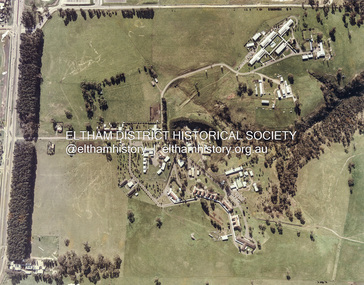
Photograph, 35 Ingrams Road, Research, Eltham Heritage Tour, 24 May 1992, 24/05/1992
... Maroondah Dam was constructed in. 1920 to replace the original weir and at that time: the Aqueduct - as established into the landscape - with bridges and tunnels and pine trees were used to stop rubbish polluting the water."...Maroondah Dam was constructed in. 1920 to replace the original weir and at that time: the Aqueduct - as established into the landscape - with bridges and tunnels and pine trees were used to stop rubbish polluting the water." ...ELTHAM HERITAGE TOUR The Society excursion on 24th May 1992 was arranged by David Bick, leader of the team carrying out the Shire's heritage study. David selected a number of sites or buildings identified in the study, some of them lesser known components of the Shire's heritage. The tour commenced at the Eltham Shire Office at 10.00 am. Travel was by private car and mini-bus with stops at about twelve locations for commentary by David.It included a short walk in Hurstbridge and lunch at Kinglake. Highlights of the tour included: - 10 am Leave from Shire Offices - 3 Important Trees - A Physical Link to Eltham's First Settlers - Toorak Mansion Gates - A Surviving Farm House - An Intact Circa 1900 Main Street - First Settlers - Gold Miners, and Timber-getters - An Early Hotel - A Pioneering Homestead - Changing Eltham Shire - 20th Century - 4 pm Afternoon Tea and Finish Tour Extract from ELTHAM CULTURAL HERITAGE TOUR (Newsletter No. 85, July 1992, by Bettina Woodburn) "On a right-angle turning of the Eltham Road is Wellers Pub, a Cobb & Co. coaching stop on the way to distant gold-fields and places north of the Yarra River. The Hotel dates from the 1870's. Daily distances for a bullock team was eight miles, horses could do double that distance. We turned into Cassells Road and on the corner of Ingrams Road we admired an elaborate Edwardian villa, 1900 style. The Aqueduct conveying Melbourne's water supply was a communication line and a technological advance in 1891. It has been enlarged and re-faced and no longer used here but piped underground. Proclaimed a linear park it has reverted to crown land, controlled by local Council. Maroondah Dam was constructed in. 1920 to replace the original weir and at that time: the Aqueduct - as established into the landscape - with bridges and tunnels and pine trees were used to stop rubbish polluting the water."Record of the Society's history and activities and highlighting various aspects of the Heritage Study undertaken by David Bick used to create the future heritage overlay for the Shire of Eltham and later Nillumbik Shire.Roll of 35mm colour negative film, 4 stripsKodak Gold 100 5095shire of eltham historical society, activities, heritage tour, ingrams road, research (vic.) -
 Federation University Historical Collection
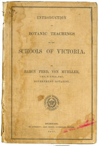
Book, Ferdinand Von Mueller, Introduction to Botanic Teachings at the Schools of Victoria, 1877
... Chapters include Eucalyptus Trees; Wattles or Acacias; Casuarinas or Sheoaks; Cypress Pines or Sandarac trees; Exocarpos trees of Natice Cherry trees; Mistletoes; Native Honeysuckles or Banksias; Bellflower, Lobelia and Goodenia; Heaths; Correas; Mallow; Buttercups and Clematis; Cruciferous Plants; Mints; Orchids; grasses; ferns. ...Chapters include Eucalyptus Trees; Wattles or Acacias; Casuarinas or Sheoaks; Cypress Pines or Sandarac trees; Exocarpos trees of Natice Cherry trees; Mistletoes; Native Honeysuckles or Banksias; Bellflower, Lobelia and Goodenia; Heaths; Correas; Mallow; Buttercups and Clematis; Cruciferous Plants; Mints; Orchids; grasses; ferns. ...Ferdinand von Mueller was an examiner of botany at the Ballarat School of Mines (SMB) between 1880 and 1888. During that era he was active in donating related items to the School. When the Ballarat School of Mines Council agreed to introduce pharmacy and botany classes in 1879, it was apparent students would require access to botanical specimens in order to further their studies. Council members, who were inspired by the work of Baron Ferdinand von Mueller, authorised development of an area along the School's northern boundary, fronting Lydiard Street South, and oversaw the establishment of the new Botanical Gardens. Baron von Mueller took a practical role the development of SMB's Botanical Gardens from the beginning. He became a generous benefactor who 'donated collections of seeds and leguminous fodder plants, including valued grasses of interest and use to agriculturalists and graziers generally' to SMB over many years. Ferdinand von Mueller's entry on the University of Ballarat Honour Roll can be found at http://www.ballarat.edu.au/curator/honour-roll/honourroll_von_mueller.shtml Also See Cat. No. 12062A light brown, hardcovered book of 152 pages. Chapters include Eucalyptus Trees; Wattles or Acacias; Casuarinas or Sheoaks; Cypress Pines or Sandarac trees; Exocarpos trees of Natice Cherry trees; Mistletoes; Native Honeysuckles or Banksias; Bellflower, Lobelia and Goodenia; Heaths; Correas; Mallow; Buttercups and Clematis; Cruciferous Plants; Mints; Orchids; grasses; ferns. The book has numerous botanical line drawings, and a comprehensive index.Inside front cover "Botanist, Teacher, researcher. My you make your mark like the baron. Best wishes for your birthday 1999 Martin"victorian, schools, botany, ferdinand von mueller, von mueller, botanic illustrations, flora, change number -
 Federation University Historical Collection
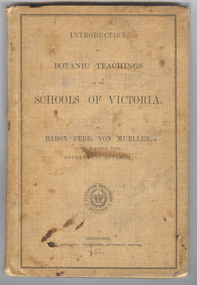
Book, Ferdinand von Mueller, Introduction to Botanic Teachings at the Schools of Victoria, 1877, 1877 (exact)
... Chapters include Eucalyptus Trees; Wattles or Acacias; Casuarinas or Sheoaks; Cypress Pines or Sandarac trees; Exocarpos trees of Natice Cherry trees; Mistletoes; Native Honeysuckles or Banksias; Bellflower, Lobelia and Goodenia; Heaths; Correas; Mallow; Buttercups and Clematis; Cruciferous Plants; Mints; Orchids; grasses; ferns. ...Chapters include Eucalyptus Trees; Wattles or Acacias; Casuarinas or Sheoaks; Cypress Pines or Sandarac trees; Exocarpos trees of Natice Cherry trees; Mistletoes; Native Honeysuckles or Banksias; Bellflower, Lobelia and Goodenia; Heaths; Correas; Mallow; Buttercups and Clematis; Cruciferous Plants; Mints; Orchids; grasses; ferns. ...Ferdinand von Mueller was an examiner of botany at the Ballarat School of Mines (SMB) between 1880 and 1888. During that era he was active in donating related items to the School. When the Ballarat School of Mines Council agreed to introduce pharmacy and botany classes in 1879, it was apparent students would require access to botanical specimens in order to further their studies. Council members, who were inspired by the work of Baron Ferdinand von Mueller, authorised development of an area along the School's northern boundary, fronting Lydiard Street South, and oversaw the establishment of the new Botanical Gardens. Baron von Mueller took a practical role the development of SMB's Botanical Gardens from the beginning. He became a generous benefactor who 'donated collections of seeds and leguminous fodder plants, including valued grasses of interest and use to agriculturalists and graziers generally' to SMB over many years. Ferdinand von Mueller's entry on the University of Ballarat Honour Roll can be found at http://www.ballarat.edu.au/curator/honour-roll/honourroll_von_mueller.shtml A light brown, hardcovered book of 152 pages. Chapters include Eucalyptus Trees; Wattles or Acacias; Casuarinas or Sheoaks; Cypress Pines or Sandarac trees; Exocarpos trees of Natice Cherry trees; Mistletoes; Native Honeysuckles or Banksias; Bellflower, Lobelia and Goodenia; Heaths; Correas; Mallow; Buttercups and Clematis; Cruciferous Plants; Mints; Orchids; grasses; ferns. The book has numerous botanical line drawings, and a comprehensive index.Inside front cover "J. Clement Souter M.D."victorian, schools, botany, ferdinand von mueller, von mueller, botanic illustrations, j. clement souter -
 Bendigo Historical Society Inc.
Newspaper - Bendigo Advertiser Collection: Schools Searching for a Future - Mandurang South Primary School 1628, August 13 1993
... This item contains the following documents: 8091.602a Part of Page 11, the Bendigo Advertiser Friday August 13 1993 8091.602b Part of Page 11, the Bendigo Advertiser Friday August 13 1993 8091.602c Black and White Photo of four kids playing cricket on the oval besides the school - Contact BHS for Details 8091.602d Black and White Photo of Grade Four student Gary Wilkins sitting under a pine tree, possibly reading - Contact BHS for Details 8091.602e Black and White Photo of Grade Four students "Bush Cooking" around a camp fire Left to Right: Travis Singe, Tristian Gillies, Gary Wilkins, Bill Riddell - Contact BHS for Details 8091.602f Black and White Photo Front of Mandurang South School - Contact the BHS for Details 8091.602g Black and White Photo Front of Mandurang South School - Contact the BHS for Details 8091.602h Black and White Photo Two men and three kids in front of the school sign. ...This item contains the following documents: 8091.602a Part of Page 11, the Bendigo Advertiser Friday August 13 1993 8091.602b Part of Page 11, the Bendigo Advertiser Friday August 13 1993 8091.602c Black and White Photo of four kids playing cricket on the oval besides the school - Contact BHS for Details 8091.602d Black and White Photo of Grade Four student Gary Wilkins sitting under a pine tree, possibly reading - Contact BHS for Details 8091.602e Black and White Photo of Grade Four students "Bush Cooking" around a camp fire Left to Right: Travis Singe, Tristian Gillies, Gary Wilkins, Bill Riddell - Contact BHS for Details 8091.602f Black and White Photo Front of Mandurang South School - Contact the BHS for Details 8091.602g Black and White Photo Front of Mandurang South School - Contact the BHS for Details 8091.602h Black and White Photo Two men and three kids in front of the school sign. ...The document highlights the challenges faced by Mandurang South, a small rural school, in the face of government education reforms and potential closure. Mandurang South was considered an easy target for closure under new government 'quality provision' guidelines. Despite demonstrating a strong curriculum and experienced leadership, the school faced severe staffing reductions: from two teachers plus specialist support to just 1.4 teachers for 32 students. This would require one teacher to manage 31 children across seven grades in a single classroom, raising concerns about educational quality. Parents and teachers collaborated intensively to prepare a submission proving the school's quality, hoping to meet government criteria for survival. Some parents, including former students, expressed willingness to close or merge the school if educational standards could not be maintained, while others wanted to keep it open. The school community was holding a referendum to decide its stance for an upcoming taskforce meeting. Mandurang South and its neighboring school, Mandurang Primary, originated from a split in 1875 due to the distances children had to travel. The school has a rich history, with its original weatherboard building and a notable stand of century-old trees, making it a model for rural education and a point of local pride. The most likely option discussed was merging with Mandurang Primary, which would be ironic given their historical split over a century ago.Mandurang South's situation serves as a test case for the broader impact of educational 'rationalisation' policies on small rural schools. Mr. Balmer was Head Teacher in 1875. Heintervened to stop residents from cutting timber on school grounds, preserving a notable stand of eucalypts and conifers.The school grounds are recognized for their natural beauty, attracting visitors and providing students with daily exposure to native wildlife and nature-based activities. The school offers standard facilities (oval, courts, shelter) and unique curriculum elements like "bush cooking," making learning relevant to its rural setting. Mandurang South School is valued at $50,000–$70,000, but faces closure due to economic constraints and potential staff reductions.There is concern that closure could lead to further school consolidations in the Mandurang valley, as part of a broader government education reform. The possible closure is seen as a loss to the community’s heritage and educational landscape, with uncertainty about the future of other local schools.Schools searching for a Future. Series of photos and information about Mandurang Primary School No. 1628. Pictures by Lisa Honeychurch. Written by Owen Davies. This item contains the following documents: 8091.602a Part of Page 11, the Bendigo Advertiser Friday August 13 1993 8091.602b Part of Page 11, the Bendigo Advertiser Friday August 13 1993 8091.602c Black and White Photo of four kids playing cricket on the oval besides the school - Contact BHS for Details 8091.602d Black and White Photo of Grade Four student Gary Wilkins sitting under a pine tree, possibly reading - Contact BHS for Details 8091.602e Black and White Photo of Grade Four students "Bush Cooking" around a camp fire Left to Right: Travis Singe, Tristian Gillies, Gary Wilkins, Bill Riddell - Contact BHS for Details 8091.602f Black and White Photo Front of Mandurang South School - Contact the BHS for Details 8091.602g Black and White Photo Front of Mandurang South School - Contact the BHS for Details 8091.602h Black and White Photo Two men and three kids in front of the school sign. Left to Right: Brian Murdoch, Brian's daughter Ebony, John's son and daughter, Roger and Erin, and John Murdoch - Contact the BHS for Details 8091.602i Black and White Photo of Mrs Bess Coghill, the former Post Mistress at Mandurang South - Contact the BHS for Details 8091.602j Black and White Photo of the school sign - Contact the BHS for Detailsnewspaper, bendigo advertiser, mandurang south, primary school -
 Sunshine and District Historical Society Incorporated
Photograph - Maribyrnong Photographs 2021 Part 2, John Alchin, 2021
... 5599.01 - Raleigh Preserving Meat Works 2021 Photo 02.JPG 5599.02 - Raleigh Preserving Meat Works 2021 Photo 03.JPG 5599.03 - Raleigh Preserving Meat Works 2021 Photo 06.JPG 5599.04 - Raleigh Preserving Meat Works 2021 Photo 09.JPG 5599.05 - Raleigh Preserving Meat Works 2021 Photo 15.JPG 5599.06 - Raleigh Preserving Meat Works 2021 Photo 17.JPG 5599.07 - Raleigh Rd - Maribyrnong Reserve 2021 Photo 01.JPG 5599.08 - Raleigh Rd - Maribyrnong Reserve 2021 Photo 03.JPG 5599.09 - Raleigh Rd - Maribyrnong Reserve 2021 Photo 04.JPG 5599.10 - Raleigh Rd - Maribyrnong Reserve 2021 Photo 05.JPG 5599.11 - Raleigh Rd - Maribyrnong Reserve 2021 Photo 12.JPG 5599.12 - Raleigh Rd Maribyrnong - Maribyrnong War Memorial And Cenotaph 2021 Photo 01.JPG 5599.13 - Raleigh Rd Maribyrnong - Maribyrnong War Memorial And Cenotaph 2021 Photo 03.JPG 5599.14 - Raleigh Rd Bridge 2021 Photo 02.JPG 5599.15 - Raleigh Rd Bridge 2021 Photo 01.JPG 5599.16 - Raleigh Rd Maribyrnong - Pine Trees 2021 Photo 01.JPG 5599.17 - Randall Rd Maribyrnong - Maribyrnong Community Centre 2021 Photo 01.JPG 5599.18 - Remont Hill Maribyrnong 2021 Photo 01.JPG ...Raleigh Road Randall Road Maribyrnong Maribyrnong Preserving Meat Works Maribyrnong Reserve Maribyrnong War Memorial And Cenotaph Maribyrnong Community Centre Remont Hill 5599.01 - Raleigh Preserving Meat Works 2021 Photo 02.JPG 5599.02 - Raleigh Preserving Meat Works 2021 Photo 03.JPG 5599.03 - Raleigh Preserving Meat Works 2021 Photo 06.JPG 5599.04 - Raleigh Preserving Meat Works 2021 Photo 09.JPG 5599.05 - Raleigh Preserving Meat Works 2021 Photo 15.JPG 5599.06 - Raleigh Preserving Meat Works 2021 Photo 17.JPG 5599.07 - Raleigh Rd - Maribyrnong Reserve 2021 Photo 01.JPG 5599.08 - Raleigh Rd - Maribyrnong Reserve 2021 Photo 03.JPG 5599.09 - Raleigh Rd - Maribyrnong Reserve 2021 Photo 04.JPG 5599.10 - Raleigh Rd - Maribyrnong Reserve 2021 Photo 05.JPG 5599.11 - Raleigh Rd - Maribyrnong Reserve 2021 Photo 12.JPG 5599.12 - Raleigh Rd Maribyrnong - Maribyrnong War Memorial And Cenotaph 2021 Photo 01.JPG 5599.13 - Raleigh Rd Maribyrnong - Maribyrnong War Memorial And Cenotaph 2021 Photo 03.JPG 5599.14 - Raleigh Rd Bridge 2021 Photo 02.JPG 5599.15 - Raleigh Rd Bridge 2021 Photo 01.JPG 5599.16 - Raleigh Rd Maribyrnong - Pine Trees 2021 Photo 01.JPG 5599.17 - Randall Rd Maribyrnong - Maribyrnong Community Centre 2021 Photo 01.JPG 5599.18 - Remont Hill Maribyrnong 2021 Photo 01.JPG This is a large collection of photographs which has been split over three identification numbers. ...Maribyrnong was originally part of the former Shire of Braybrook and later the City of Sunshine. However, in 1994, Victoria underwent council amalgamations, which resulted in Braybrook being incorporated into the City of Maribyrnong. The suburb of Maribyrnong continues to attract considerable attention from the residents of City of Brimbank, particularly its historical features, the old buildings and distinctive streetscapes that characterise the area.To capture the essence of Maribyrnong in 2021, a series of photographs were taken. These images document a range of buildings, street scenes, and other notable points of interest throughout the suburb, providing a visual record of its unique character.5599.01 - Raleigh Preserving Meat Works 2021 Photo 02.JPG 5599.02 - Raleigh Preserving Meat Works 2021 Photo 03.JPG 5599.03 - Raleigh Preserving Meat Works 2021 Photo 06.JPG 5599.04 - Raleigh Preserving Meat Works 2021 Photo 09.JPG 5599.05 - Raleigh Preserving Meat Works 2021 Photo 15.JPG 5599.06 - Raleigh Preserving Meat Works 2021 Photo 17.JPG 5599.07 - Raleigh Rd - Maribyrnong Reserve 2021 Photo 01.JPG 5599.08 - Raleigh Rd - Maribyrnong Reserve 2021 Photo 03.JPG 5599.09 - Raleigh Rd - Maribyrnong Reserve 2021 Photo 04.JPG 5599.10 - Raleigh Rd - Maribyrnong Reserve 2021 Photo 05.JPG 5599.11 - Raleigh Rd - Maribyrnong Reserve 2021 Photo 12.JPG 5599.12 - Raleigh Rd Maribyrnong - Maribyrnong War Memorial And Cenotaph 2021 Photo 01.JPG 5599.13 - Raleigh Rd Maribyrnong - Maribyrnong War Memorial And Cenotaph 2021 Photo 03.JPG 5599.14 - Raleigh Rd Bridge 2021 Photo 02.JPG 5599.15 - Raleigh Rd Bridge 2021 Photo 01.JPG 5599.16 - Raleigh Rd Maribyrnong - Pine Trees 2021 Photo 01.JPG 5599.17 - Randall Rd Maribyrnong - Maribyrnong Community Centre 2021 Photo 01.JPG 5599.18 - Remont Hill Maribyrnong 2021 Photo 01.JPG raleigh road, randall road, maribyrnong, maribyrnong preserving meat works, maribyrnong reserve, maribyrnong war memorial and cenotaph, maribyrnong community centre, remont hill -
 City of Moorabbin Historical Society (Operating the Box Cottage Museum)
Photographs, x 3 Black & White Cheltenham Football Club 1909,1913, 1946, 20thC
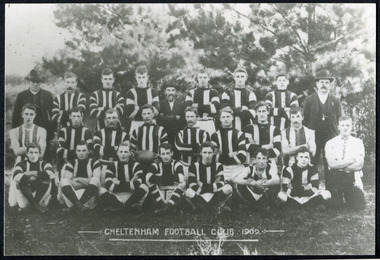
... The Moorabbin council then leveled the playing area and erected a post and rail fence around the ground. Pine tree shrubs were then planted on the west side of the ground. ...The Moorabbin council then leveled the playing area and erected a post and rail fence around the ground. Pine tree shrubs were then planted on the west side of the ground. ...Known as the Rosellas, the early Cheltenham Football Club sides began playing on a regular basis in 1890, and would travel long distances by steam train to play country teams, such as Ballarat where they would arrive at their destination, play the match, socialize then return to the station. Opposition players and supporters would give three hearty cheers on their departure. The Cheltenham home games were played on a paddock on the corner of Park and Charman roads in Cheltenham. In 1907 the Cheltenham progress committee made an application to the board of land works for land in Weatherall Road for recreational service to the public. That application was received and granted, then developed where Cheltenham Recreational Reserve now stands. The land in the early days was virgin bush and the response for voluntary help to clear the area was outstanding. Nearly all the market gardeners in the district along with horses, ploughs, axes, shovels completely cleared the area in three weeks. The Moorabbin council then leveled the playing area and erected a post and rail fence around the ground. Pine tree shrubs were then planted on the west side of the ground. The ground was opened in 1909 and the first Cheltenham side entered in the newly formed Federal Football Association along with seven other foundation members, Mordialloc, Mentone, Moorabbin, Frankston, Glenhuntly, Elsternwick, and Ellindale. The grand final for that year, 1909 was a hard encounter between Cheltenham and Ellindale with Cheltenham coming out victors, thus becoming the inaugural Federal Football Association premiers. Cheltenham went onto win five senior premierships in the Federal Football Association by the end of the 1920s, they won the flags in 1909, 1911, 1913, 1922 and 1925, with the late Percy Woff playing in all 5 premiership sides and was captain in 1922. 1928 saw the start of an outstanding career from our oldest living player Tom Connor. Cheltenham continued to win premierships in the 1920’s and 1930’s with juniors taking out the 1929 and 1933 flags, under the guidance of Woff, and that continued in 1934 when Cheltenham took out the 1st XVIII and 2nd XVIII premierships. Cheltenham produced its only Brownlow medallist in Peter Box who played in the late 1940s, before going to Footscray where he became a champion. The 3rd XVIII went through the season undefeated in 1974 winning the premiership, with Trevor Barker a key player before going to St Kilda the following year. The club won three senior premierships under coach Barry White in 1992, 1993 and 1995. ( from CFNC website 2019) Cheltenham Football Club was formed 1890 and succeeded in winning many Premierships as a member of the Federal Football Association, Outstanding players Peter Box Brownlow Medalist 1956 Footscay VFL, , Trevor Barker and Kevin Roberts St Kilda VFL.3x Black & White photographs of the players in the Australian Rules Cheltenham Football Club 1909, 1913 and 1946 extra photo of Peter Box Folio 10 MAV 01059a) CHELTENHAM FOOTBALL CLUB 1909 Cheltenham Football Club 1909. Back row: A Chandler, committee member; R. Robertson, back-pocket; J. Harris, half back flank; J Adams, ruck and forward-pocked; M. J. Monk, club president; L. Woff, back-pocket; W. Adams, ruck and back-pocket; P. Woff, rover and forward-pocket; A Monk, committee member. Middle row: W. Hore, back pocket and ruck; A. Towns, half-forward flank; W. Carson, full back; F. Andrews, captain-half forward flank; H. Butler, centre half back; J. Warburton, centre half-forward; A. Slater, half-back flank; F. Fisher, half-forward flank; C. Sherwood, trainer. Front Row: G Gouldthorpe, wing; H. King, full-forward; W. Johnston, ruck and forward-pocket; P Spears, rover and forward-pocket; F. Bichl, wing; A. Bichl. rover and forward-pocket; F. Butler, centre player. Courtesy, Lionel Seal. ( from CFC website 2019) b) CHELTENHAM 1913 PREMIERS c) CHELTENHAM -1946 / Back row - J. Fisher, G.Corrigan, N.Hocking, F.Virtue, R.Craven, L.Baker, M.Blundell / 2nd Row - J.Phillips, T.Connor, E.Hawkins, A.Blakely, G.Baker, A.Dark, J.Barker, D.Craven, J.Pickering, P.Cameron,/ W.Hicks, G.Hoskings, R.Beihl, A.Hubbard, R.Kier, C.Russell. / Front Row - Clark Taylor, J.Slade, N.Niel, J.Brooks, T,Butler, H.Hosking, C.Hacusler, E.Hornibrook, W.Briggs, B.Russell, L.Biehl, / W Ripponcheltenham football club, australian rules football, victorian football association, victorian football league, smith j l; smith mary ann, stanley helen, , chaff cutter, horse drawn carts, toll gates brighton, motor cars 1900, steam engines, early settlers, bentleigh, parish of moorabbin, city of moorabbin, county of bourke, moorabbin roads board, shire of moorabbin, henry dendy's special survey 1841, were j.b.; bent thomas, o'shannassy john, king richard, charman stephen, highett william, ormond francis, maynard dennis, market gardeners, vineyards, orchards, cheltenham, two acre village, holloway josiah,, woff percy, connor tom, box peter, barker trevor, white barry, browlow charles, -
 Federation University Art Collection
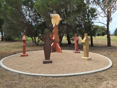
Sculpture, 'Mungo Moon' by Don Barrett, 2015
... There are already art features along this route, including primary schools’ Bug Blitz totems near the Kurnai College school crossing, native vegetation and history panels near the Hare Homestead in Mathison Park, and outdoor sculptures in the pine trees near the Federation University Switchback Gallery. ...There are already art features along this route, including primary schools’ Bug Blitz totems near the Kurnai College school crossing, native vegetation and history panels near the Hare Homestead in Mathison Park, and outdoor sculptures in the pine trees near the Federation University Switchback Gallery. churchill art and culture pathway barrett don barrett gippsland campus federation university churchill sculpture A large sculpture in five pieces set in an external location. ...'Mungo Moon' by Don Barrett is the first sculpture erected on the Churchill Art and Culture Pathway. It was officially unveiled by Professor David Battersby on 15 April 2015 From Churchill & District News 16 October 2014 The Churchill Art and Culture Walking Pathway will have its official public opening on Saturday October 18, with a walk finishing at Federation University Australia’s Switchback Gallery at the Federation University Gippsland Campus. ... An important link on the newly developed pathway was recently completed with a path south of the FedUni Student West Residences. The path now allows walkers to turn off the Eel Hole Creek path before reaching Glendonald Estate and to follow a picturesque, tree lined walkway to join up with the footpath on the Eastern side of Northways Road. From there the footpath joins into Federation University’s network of walking paths that proceeds past the Switchback Art Gallery, down through the pine plantation and along Lake Kretlow and the Churchill Golf Course. Project Manager Mike Answerth, said the opening of the West Residences section of the path means there is now only one short link to complete. “We’re now very close to realising the project’s objective to join up all these walking paths to provide a continuous pathway that encompasses town, campus and parkland. The next stage of the project will be the completion of Latrobe City’s East West Link and the enhancement of the walking path with artistic and cultural features.” said Mr. Answerth. Head of Federation University Australia Gippsland Campus, Dr Harry Ballis, said the project had been made possible through the contributions of the five former Gippsland Education Precinct (GEP) partners. “The Art and Culture Pathway represents another important step in joining the Churchill township and the university campus as a physical and social entity,” Dr Ballis said. “This was an initiative of the GEP and it is pleasing to see it coming to fruition.” The path now reaches as far as the golf driving range but plans are already under way to connect with the Mathison Park board walk and pathway, which surrounds Lake Hyland in Churchill. When the loop is completed, residents and visitors will have an approximately 5km circular walking path which links up the Churchill town centre, Federation University Australia and Mathison Park. There are already art features along this route, including primary schools’ Bug Blitz totems near the Kurnai College school crossing, native vegetation and history panels near the Hare Homestead in Mathison Park, and outdoor sculptures in the pine trees near the Federation University Switchback Gallery. contemporaryA large sculpture in five pieces set in an external location. It is part of the Churchill Art and Culture Walking Pathway. Don Barrett’s work is mainly in concrete with added coloured oxides to portray the feeling of the Australian landscape. Barrett focuses on concepts of Australia’s short history and indigenous history. churchill art and culture pathway, barrett, don barrett, gippsland campus, federation university, churchill, sculpture -
 Bayside Gallery - Bayside City Council Art & Heritage Collection
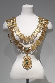
Ceremonial object - Mayoral chain, Blashki, City of Sandringham Mayoral Chain, c. 1954
... The main medallion has an oval central panel that features the coloured Sandringham seal in enamel depicting two sailboats in the water, a pier protruding from the left, a coastline on the right with two pine trees. Above the scene are decorative triangles in light blue and yellow, above which is another section in dark blue containing a third sailboat. ...The main medallion has an oval central panel that features the coloured Sandringham seal in enamel depicting two sailboats in the water, a pier protruding from the left, a coastline on the right with two pine trees. Above the scene are decorative triangles in light blue and yellow, above which is another section in dark blue containing a third sailboat. ...This chain was part of the official regalia worn by the Mayor of the City of Sandringham before the amalgamation into Bayside City Council in 1994. The chain was seen as an outward sign of power, authority, and responsibility and was a formal, full-dress type of regalia that was worn by the mayor over their robes at ceremonial functions. The large central drop medallion features the design of the council sea, and the links of the chains are made of cutwork initials of each Mayor. The Sandringham seal was designed by Sans and McDougal had been selected in 1917, by a special committee and its main features are the Sandringham pier and breakwater, with a yacht in full sail as an inset, supported by two dolphins. The motto reads 'Omni Opere' which translates to ‘With all earnestness.’9 carat yellow gold mayoral chain for the City of Sandringham. Consists of two concentric circles of 57 small oval links, with an Australian Coat of Arms as a centrepiece and a large 'drop' medallion of the City of Sandringham seal below. Each oval link is made up of the cutwork initials of a mayor, the surrounding oval border has an inscription above the initials which gives the mayor's name; an inscription below gives dates of office; the earliest is Cr. B.J. Ferdinando 1917-18, and latest is Cr. S.T. Russell 1993-94. The ovals are surrounded by decorative scrolls and are joined by small curb chains. The outer circle contains 31 links, while the inner contains 26. On both shoulders sit decorative bars, joining the front of the chain to the back. The main medallion has an oval central panel that features the coloured Sandringham seal in enamel depicting two sailboats in the water, a pier protruding from the left, a coastline on the right with two pine trees. Above the scene are decorative triangles in light blue and yellow, above which is another section in dark blue containing a third sailboat. The seal is flanked by two engraved dolphins and above it sits an engraved St Edward's gold crown filled with red enamel. Below the seal, there is a ribbon containing the Latin motto 'OMNI OPERE' which is engraved and filled in dark blue enamel. The pendant is surrounded by cutwork lettering reading 'CITY OF SANDRINGHAM / 1919' and leaf decorations. The medallion is inscribed on the reverse with important dates in Sandringham's history. A fleur-de-lys joins the medallion to the Australian Coat of Arms centrepiece above. The Coat of Arms features a shield, depicting symbols of Australia's six states, in enamel, flanked by an engraved kangaroo on the left and emu on the right. Below it sits a ribbon engraved 'ADVANCE AUSTRALIA'.mayoral chain, ceremonial wear, seal, medallion, mayor, coat of arms, crest, bayside, blashki & sons, city of sandringham, sandringham, omni opere, blashki, mayoral regalia, motto, st edward's crown, sans and mcdougall -
 Mt Dandenong & District Historical Society Inc.
Photograph, Kalorama Gap Under Snow 1921, 1921
... At the bend of the road behind the big pine tree and the dark blackwood can be seen faintly the gable of Price’s house that contained the first shop on the mount. ...At the bend of the road behind the big pine tree and the dark blackwood can be seen faintly the gable of Price’s house that contained the first shop on the mount. ...View of Kalorama Gap under snow taken in 1921. Mountjoy Guest House is at top right and Beulah Tea Rooms is in the centre. This photograph has a detailed inscription on the back handwritten by John Lundy-Clarke in 1974.Kalorama Gap under snow 1921 The leafless elm trees are low in the centre and the dual nature of the nearer one can be clearly seen, two small suckers of the older farther tree being twisted together in 1898 by Fred Jeeves. The older tree was planted 1880. Mrs Hands shop can be clearly seen, which was the Mount Dandenong North Post Office. The old Main Road runs up the centre of the picture and turns to the right and disappears behind “Mountjoy” the big guest house built by Paynters in 1905 and sold to Ellis Jeeves 1908, whose family ran it till 1943. At the bend of the road behind the big pine tree and the dark blackwood can be seen faintly the gable of Price’s house that contained the first shop on the mount. Above it is H Walker’s cottage on Ridge Road that still exists, his homestead is on the left of the picture on the same level. Below this house and to the left can be seen Ted Prices hay and corn store. The present estate agency lies between these two buildings, on the road which had recently been built. This can be seen winding from the lower left corner of picture to the left of the elms. The CRB had recently fenced the road and this is clearly seen as it circles behind trees in the left centre. Barber’s Road crosses CRB Road to the left of the dray under the leafless elm and the Coach Road dives down to the right just behind the pair of blackwoods to right of the elms. The picture was taken from just above the boundary of Isaac Jeeves’s selection Crown Allotment “C” (Jeeves Saddle) which stretched across the Gap to the other side of Mrs Hand’s shop, monopolising the gap from 1871 to 1879. Price’s house remains partly as the small house – “Mirra Laken”. kalorama gap, fiveways, post office, mountjoy, guest house, snow -
 Eltham District Historical Society Inc
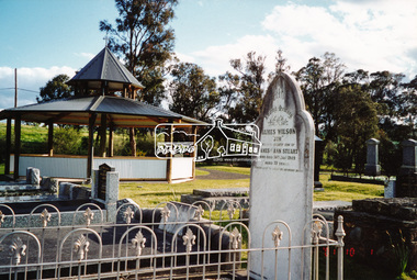
Photograph, A walk through the cemetery at Kangaroo Ground, Diana Bassett-Smith, 1 October 2001, 2001
... It was a Wilson who had a nursery at the North Eastern end of Bourchiers Road on the land known as Tintagell alongside the Yarra. He grew trees, pines in particular, and supplied within the district and to the gardens of Melbourne. ...It was a Wilson who had a nursery at the North Eastern end of Bourchiers Road on the land known as Tintagell alongside the Yarra. He grew trees, pines in particular, and supplied within the district and to the gardens of Melbourne. ...The Kangaroo Ground Cemetery celebrated its 150th anniversary in 2001. Celebrations included the opening of a new rotunda on the 26 October 2001. Ths photo is a part of a brief collection of reminiscences by Diana Bassett-Smith of locals who are buried at Kangaroo Ground Cemetery along with 17 photographs following a visit on 1 October 2001. "One other headstone, that of James Wilson. It was a Wilson who had a nursery at the North Eastern end of Bourchiers Road on the land known as Tintagell alongside the Yarra. He grew trees, pines in particular, and supplied within the district and to the gardens of Melbourne. According to Jimmy Cook. The last of the warriors is between the gate and the river. And confirmed by Dorrie Bourchier that the original pines to what is now our property came from Wilson. The only one left now is by Passiona. Lightening claimed the one at the corner of our drive." Colour photograph printkangaroo ground cemetery, rotunda, james wilson -
 Eltham District Historical Society Inc
Photograph - Colour Print, Janefield, Bundoora, c.1982
... Mick informed Peter that it was his job to remove the 14 acres of pine tree roots, after the trees were cut down (due to old age and an infestation of sap sucking insects). ...Mick informed Peter that it was his job to remove the 14 acres of pine tree roots, after the trees were cut down (due to old age and an infestation of sap sucking insects). ...The photo encompasses what is present-day University Hill shopping complex and the Janefield Wetlands. Plenty Road is just visible to the left of the photo. Janefield was an area 18 km north-east of central Melbourne that is now part of Bundoora. In 1842 a flour mill, powered by the Plenty River, was built at Janefield, although the locality was not known by that name at that time. It seems that the name Springfield was used in the late 1840s, after a Springfield homestead, and this was changed to Janefield possibly upon the death of Jane Brock in 1847. She was the wife of James Brock, a local landowner and son of the purchaser of the flour mill. This photo is not strictly within the area of interest for EDHS but overlaps do occur at times with other Society’s interests through families and other associated connections. Eltham District Historical Society member (and Greensborough Historical Society member), Peter Van Eeken was undertaking research into this photo and approached the Local History Librarian at Yarra Plenty Regional Library to enquire about digitising the large print copy to facilitate research. Approaches were made to EDHS who had suitable facilities and were willing to accommodate and all parties agreed to add the image as part of their respective collections in partnership. Michael Lanigan, started work as a message boy at Mont Park when he left school at age 14. He worked his way up the system to become farm manager at Mont Park and Janefield Special School. He was one of the last people to drive a herd of cattle (in 1964) between the two locations along Plenty Road. He retired when the school closed around 1993. Mick pointed out the location of three remnant farm houses of the 1800s. The Brock House being the main one. Peter has been unable to find any photos of the Brock House, which what built in the late 1850s, severely burnt in the 1930s and demolished in the mid 1960s. The tree plantation along Plenty Road was established in 1930 and cut down in the mid 1980s. The Victorian Government established tree plantations at about 350 schools in the early 1930s. Briar Hill School had one but Peter is not sure about any other local schools having a tree plantation. Mick informed Peter that it was his job to remove the 14 acres of pine tree roots, after the trees were cut down (due to old age and an infestation of sap sucking insects). For Mick, this was an impossible job, so he arranged a contract, to house all the soil removed from works associated with the construction of the Greensborough Bypass, which needed temporary storage as it was too valuable, and would be great for use in road construction. The contract to store the soil was important to Mick, as the contract stipulated that when the soil was eventually removed, the tree roots had to be removed too. Which got rid of Mick's headache. Apparently, the huge mound of soil that covered the roots in the late 1980s could be seen from Briar Hill. Based on this, the photo is most likely to have been taken 1982 or 1983. The key to a final date is working out when the Board of Works Office opened but so far no information has come to light. (It was purchased by La Trobe University in 1991). The Office existed, or is hinted at, in the photo at the extreme north of the photo, opposite McKimmies Road, on the eastern side of Plenty Road. Photo on loan from Michael Lanigan via Peter Van Eeken. He cannot recall why it was taken. brock family, janefield, janefield drive, janefield wetlands, plenty road, university hill -
 Old Colonists' Association of Ballarat Inc.
Photograph - Photograph - Colour, Ballarat Old Colonists' Association Homes, Charles Anderson Grove, Ballarat
... In the same year the first 290 pine trees were advertised for removal in July and sold for £16. ...In the same year the first 290 pine trees were advertised for removal in July and sold for £16. ...HISTORY OF THE BALLARAT OLD COLONISTS' ASSOCIATION HOMES AT CHARLES ANDERSON GROVE, LAKE GARDENS One of the original objectives of the Association was “to provide the shelter of a house for those Pioneers of the Goldfields whom the reverses of fortune have deprived of the means of procuring the comforts of life in their declining years.” While the first home at Charles Anderson Grove was built in 1925 the Association had previously provided relief for needy pioneers from the time it was formed in 1883. Relief included monthly monetary payments, loads of firewood, medical assistance and distribution of Christmas boxes of groceries to deserving pensioners and in some cases payment of burial costs. Records indicate that in September 1922 three of the pensioners being assisted by the Association were accepted as residents in the newly erected Hassell Homes in Gillies Street (now demolished-opposite the High School). The first site for an Asylum for Indigent Members of the Old Colonists' Association was temporarily reserved from sale in October 1891. The site was approximately 28 acres in area in Mt Clear nearly opposite Midvale Shopping Centre in Main Road. The site was heavily timbered and when cleared over 260 tons of wood was sold to the Woah Hawp Gold Mining Company. A set of gates were erected but no homes built, although a plan for this reserve was drawn which showed twenty buildings ranging from one to four unit per building. The reserve was revoked in November 1909. The second site temporarily reserved in November 1909 as an Asylum was in Alfredton and consisted of some 7 acres and was adjacent to land reserved for an Abattoirs for the Ballarat Council. The reserve was revoked in February 1912 as it was deemed more appropriate to be added to the Abattoir site. Council suggested four (4) other sites in exchange for this land and they were inspected by the President, Vice President and Secretary on 22 December 1912. The first site inspected was land on the west side of Creswick Road opposite the brick kilns (now occupied by the showgrounds and oval). The land was described as being good quality, well fenced, no trees, good drainage and ample acreage but some distance from trams. The second site was Perry Park which was described as being good land, well fenced, having frontage to Gillies Street, good drainage and about 26 acres (but subsequently reduced to 10 acres). It was closely planted with Pinus Insignias and Wattle and had easy access from the Botanic Gardens tram. The third site was the North West portion of Victoria Park (corner of Sturt and Gillies Street) and was described as good land, well fenced and drained and well located. The fourth site was the South West corner of Victoria Park and known as Pound Paddock (corner of Winter Street and Gillies Street). It was considered to be low lying and too close to the Abattoir, and was also a considerable distance from trams. While the third site was recommended as the most suitable for the erection of homes it was considered unwise from the point of view as citizens to reduce the acreage of the park and therefore it was recommended that the Perry Park site be asked for as the most acceptable to the Association for the building of homes. The site was eventually temporarily reserved for an Asylum for Indigent Members of the Association in April 1914 with the gates from Mt Clear having been removed to the site a year earlier and eventually erected in 1917 for £12.10.0. In the same year the first 290 pine trees were advertised for removal in July and sold for £16. A sign indicating that the site was reserved for the erection of cottages was erected in September 1917. Stripping of the wattle bark (for tanning) and the cutting of the wood occurred in November 1918 with the land then being leased until it was required for the construction of the first homes in 1924. While the site was the third to be reserved it was the only one which was used for its intended purpose. It was named as Charles Anderson Grove in honour of Charles Anderson who joined the Association in 1918 and was President of the Association from 1942 to 1944. A number of cottages in the Ballarat Old Colonists' Association Retirement Village of Gillies Street, Ballarat.charles anderson grove, old colonists' club, ballarat, old colonists' association, old colonists' homes, retirement village -
 Kew Historical Society Inc
Photograph, J F C Farquhar, Railway Bridge Over the Yarra, 1891
... The landscape surrounding the Asylum was planted with traditional exotic trees such as Oaks, Pines and Cedars, and landmark trees from northern Australia such as the Hoop Pine. ...The landscape surrounding the Asylum was planted with traditional exotic trees such as Oaks, Pines and Cedars, and landmark trees from northern Australia such as the Hoop Pine. ...At the beginning of the 1890s, the Kew businessman and Town Councillor, Henry Kellett, commissioned J.F.C. Farquhar to photograph scenes of Kew. These scenes included panoramas as well as pastoral scenes. The resulting set of twelve photographs was assembled in an album, Kew Where We Live, from which customers could select images for purchase.The preamble to the album describes that the photographs used the ‘argentic bromide’ process, now more commonly known as the gelatine silver process. This form of dry plate photography allowed for the negatives to be kept for weeks before processing, hence its value in landscape photography. The resulting images were considered to be finely grained and everlasting. Evidence of the success of Henry Kellett’s venture can be seen today, in that some of the photographs are held in national collections.It is believed that the Kew Historical Society’s copy of the Kellett album is unique and that the photographs in the book were the first copies taken from the original plates. It is the first and most important series of images produced about Kew. The individual images have proved essential in identifying buildings and places of heritage value in the district.Completed in November 1890, the railway viaduct (now the Chandler Highway Bridge) linked Kew and Fairfield. The viaduct is significant as the most substantial extant engineering remnant of the Outer Circle Railway Line. Opened in March 1891, the viaduct crossed the Yarra River in a single span, atop three supporting brick pillars. Following the closure of the railway line in 1927, and the construction of the Chandler Highway in 1930, the bridge was used for vehicular traffic. In 1891 when this panoramic photograph was taken, the grounds of what was then the Kew Lunatic Asylum extended down to the River and eastward beyond the viaduct. The landscape surrounding the Asylum was planted with traditional exotic trees such as Oaks, Pines and Cedars, and landmark trees from northern Australia such as the Hoop Pine. Remnant indigenous trees such as the River Red Gum, Yellow Box and Lightwood were scattered around the site, including beside the Yarra River.Railway Bridge Over the Yarrakew illustrated, kew where we live, photographic books, henry kellett, railway viaduct - - kew (vic) -
 Eltham District Historical Society Inc
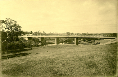
Photograph - Digital Photograph, Alan King, Maroondah Aqueduct Siphon Bridge over the Plenty River, 26 January 2008
... Since the 1980s the land along parts of the aqueduct have been used for walking and bicycle riding, shaded in places by Monterey Pine trees planted to stabilise the surrounding ground. ...Since the 1980s the land along parts of the aqueduct have been used for walking and bicycle riding, shaded in places by Monterey Pine trees planted to stabilise the surrounding ground. ...Opened in 1891, the bridge formed part of the Maroondah Aqueduct carrying water from Watts River near Healesville to the reservoir at Preston where it joined Melbourne's metropolitan water system. Covered under Heritage Overlay, Nillumbik Planning Scheme. Published: Nillumbik Now and Then / Marguerite Marshall 2008; photographs Alan King with Marguerite Marshall.; p99 Built to supply thirsty Melbourne in the late 19th century, the siphon bridge spanning the Plenty River off Leischa Court, Greensborough, was part of an engineering masterpiece. Opened in 1891, the bridge formed part of the Maroondah Aqueduct carrying water from the Watts River near Healesville to the reservoir at Preston where it joined the metropolitan distribution system. A major link in Melbourne’s water supply, it also had a huge impact on communities, which mushroomed along its route. Named after the Aboriginal word for the area around the Maroondah Reservoir, the Maroondah Aqueduct was fully operational until the 1970s. Since the 1980s the land along parts of the aqueduct have been used for walking and bicycle riding, shaded in places by Monterey Pine trees planted to stabilise the surrounding ground. From 1857 the Yan Yean Reservoir supplied Melbourne’s water but the growing city needed additional catchments.1 In 1886 work began on a weir on the Watts River to enable the aqueduct to carry most of the river water 41 miles (66km) to Melbourne. The aqueduct, built by the Board of Works, is the oldest remaining aqueduct near Melbourne and was probably the first built with concrete.2 Although the aqueduct is now only used between the Maroondah and Sugarloaf Reservoirs, it can still be traced across the Shire. It extends from the Maroondah Reservoir through Christmas Hills, Kangaroo Ground, Research, Eltham, St Helena and then previously wound west through Greensborough to Reservoir.3 Built by horse and manpower the aqueduct gravity fed 25 million gallons (113.6ML) of water a day to Melbourne along a gradient of one foot to the mile. It included 25 miles (41km) of open concrete and brick channel, six miles (10km) of tunnels, and nine miles (15km) of 14 inverted siphons of riveted wrought-iron across creeks. Bricks for the aqueduct were made from clay found near the sites and remains of several kilns can still be found between Kangaroo Ground and Christmas Hills. Building the aqueduct transformed local communities. An abattoir was established at Christmas Hills. Grog shanties and labourers’ camps sprang up and local courts dealt with cases of ‘petty pilfering and boisterous behaviour’.4 The Kangaroo Ground school population jumped to 91, crammed into a room with one teacher. Miners who built the tunnels camped just north of Churinga in Greensborough – then called Tunnel Hill Camp – and adjacent to the Evelyn Arms Hotel. The miners’ high spirits were sometimes quenched in horse troughs or by a ‘welt under the ear and kick on the behind’ as the local constable calmed them down rather than lock them up.5 But the growing city of Melbourne needed more water, so the O’Shannassy catchment, east of Warburton, was added to the system in 1914. In 1920 work began on the present concrete Maroondah Dam one mile (1.6km) from the weir on the Watts River. The aqueduct capacity was thus doubled to 50 million gallons (227ML) a day.6 Intense land development threatened to pollute the open water supply, so channel sections were replaced with large pipes. In the late 1960s a large water main was built from the tunnel outlet at Research and extended through St Helena and Greensborough, so this section of the aqueduct was taken out of use. Long sections of the unused open channels in Greensborough and Bundoora were destroyed, but the old channel in Research and Eltham North remained largely intact. In the 1970s, the Sugarloaf Reservoir was constructed, inundating 445 hectares of land in Christmas Hills. Sugarloaf was officially opened in 1980 and serves as a water storage and treatment plant supplying Melbourne. In the early 1980s pipes replaced the section from Sugarloaf Reservoir to the tunnel entrance at Kangaroo Ground. The Research-Kangaroo Ground tunnel operates as part of the pipeline system.This collection of almost 130 photos about places and people within the Shire of Nillumbik, an urban and rural municipality in Melbourne's north, contributes to an understanding of the history of the Shire. Published in 2008 immediately prior to the Black Saturday bushfires of February 7, 2009, it documents sites that were impacted, and in some cases destroyed by the fires. It includes photographs taken especially for the publication, creating a unique time capsule representing the Shire in the early 21st century. It remains the most recent comprehenesive publication devoted to the Shire's history connecting local residents to the past. nillumbik now and then (marshall-king) collection, maroondah aqueduct, pipe bridge, siphon bridge -
 Eltham District Historical Society Inc
Photograph - Digital Photograph, Alan King, Original Kangaroo Ground Primary School No. 2105 building, Eltham-Yarra Glen Road, Kangaroo Ground, 28 December 2007
... The small playground, surrounded by pine trees and a picket fence, was extended in 1931 with an additional acre or so (0.4 ha) of land. ...The small playground, surrounded by pine trees and a picket fence, was extended in 1931 with an additional acre or so (0.4 ha) of land. ...Kangaroo Ground's first school began in 1851 with 22 pupils from the district's ten families. It was a single room school located further south on the site, which also served as a Presbyterian church. The first teacher was Andrew Ross. The school building was used as a Post Office between 1854 and 1858 and during 1857 also served as a Court of Petty Sessions. With a growing farming community, a new building was warranted and the original Sate School No. 352 was closed and a new building, State School No. 2105 was oipened October 1, 1878. A residence for Head Teacher Henry Wallace School was erected in 1879 attached to the left of the school building. That residence is now home to the Andrew Ross Museum, which opened in 1993. Covered under Heritage Overlay, Nillumbik Planning Scheme. Published: Nillumbik Now and Then / Marguerite Marshall 2008; photographs Alan King with Marguerite Marshall.; p35 In a corner of the Kangaroo Ground Primary School playground stands an old weatherboard building. This structure, attached to the former teacher’s weatherboard residence facing Main Road, first served as a school in 1878. The former residence, built in 1879, houses the Andrew Ross Museum, which opened in 1993. It is named after the school’s first teacher,1 who also founded The Evelyn Observer newspaper, which began on the site in 1873. Later the printing presses were moved to brick newspaper offices by the Kangaroo Ground Hotel, which became the Shire of Eltham offices. However Kangaroo Ground’s first school began in 1851 for 22 pupils from the district’s ten families, in a slab building further south on this site. Andrew Harkness and other settlers campaigned for the building, which was built on half an acre (0.2ha) donated by local farmer, James Donaldson. Builder was Samuel Furphy, father of the novelist Joseph.2 The single room measuring 30 feet x 18 feet (9m x 5.5m), was unlined and the green slabs shrank, allowing the wind and rain entry through cracks except when they were stuffed with paper.3 The building served as a Presbyterian church as well as a school, where fees were 18 pence a week for education. Young men also attended evening classes there in winter. At one stage, a corner of the room was curtained off for the schoolmaster’s living space, and the platform, which was used for sleeping, was also the pulpit during church services. Teacher Andrew Ross also took church services when the minister was unable to attend, which happened frequently as he had long distances to travel on the bad roads. In 1857 the school building was also used as the Court of Petty Sessions, and from 1854 until 1858, it served as a post office. During the gold rush fossickers on their way to the Caledonia Diggings at Queenstown (now St Andrews) prospected the district, but did not remain long, as the fields were not rich in gold. But the farming community grew, until by 1878 the population warranted the building of State School No 2105 – the present one-roomed tongue-and-groove lined building measuring 49 feet x 18 feet (15m x 5.5m), to accommodate 60 children. The old school, No 352, was closed, and the new one opened on October 1, with Henry Wallace as head teacher, assisted by work mistress Annie Johnston. Early teachers included Messrs Smith, Hamilton and Prosser, with sewing teachers Misses Sweeney, Limerock and Oliver. In the early 1920s a small room was built on the front veranda of the teacher’s residence, and used as a State Savings Bank agency until about 1934. In 1928 the schoolroom’s three-tiered floor was replaced by a flat floor and teacher’s platform (which has since been removed). A half-glassed partition wall then divided the large room into two rooms in which the old style form-type desks were replaced with dual desks. The small playground, surrounded by pine trees and a picket fence, was extended in 1931 with an additional acre or so (0.4 ha) of land. During World War Two the school faced closure because of a fall to seven in the enrolment, but by 1946 it had increased again to 45. Mr Eric Morgan was head teacher and Mrs Margaret Banks was assistant head teacher, a position she held for ten years. In 1955, under the head teacher Mr V Gardiner, who taught there for 13 years, the school won a prize for the best-kept garden and school ground in the inspectorate. A district subdivision increased the enrolment in 1968 to 65 and a bus service was established. After the hall which had been used for lessons was demolished late that year, the pupils met in the original fire brigade meeting room (now the tennis club, diagonally opposite the general store). The new school building with a storeroom and staffroom was built in 1974.This collection of almost 130 photos about places and people within the Shire of Nillumbik, an urban and rural municipality in Melbourne's north, contributes to an understanding of the history of the Shire. Published in 2008 immediately prior to the Black Saturday bushfires of February 7, 2009, it documents sites that were impacted, and in some cases destroyed by the fires. It includes photographs taken especially for the publication, creating a unique time capsule representing the Shire in the early 21st century. It remains the most recent comprehenesive publication devoted to the Shire's history connecting local residents to the past. nillumbik now and then (marshall-king) collection, kangaroo ground, andrew ross museum, eltham-yarra glen road, kangaroo ground primary school no. 2105, kangaroo ground state school, state school no. 2105 -
 Old Colonists' Association of Ballarat Inc.
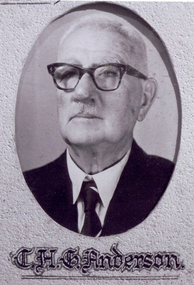
Photograph - Image, The History of Charles Anderson and Charles Anderson Grove, Ballarat
... In the same year the first 290 pine trees were advertised for removal in July and sold for £16. ...In the same year the first 290 pine trees were advertised for removal in July and sold for £16. ...Information relating to Charles Anderson and Charles Anderson Grove, Lake Gardens, Ballarat. The Old Colonists' Association Ballarat Inc. is a not for profit charitable organisation providing accommodation for elderly people. It manages a 27 Home retirement village at Charles Anderson Grove, Ballarat. Accommodation is offered at significantly below market rates. It has been providing low cost accommodation to the elderly since the 1920s. The Association Council overseas the running of this facility on a voluntary basis. HISTORY OF THE BALLARAT OLD COLONISTS' ASSOCIATION HOMES AT CHARLES ANDERSON GROVE, LAKE GARDENS One of the original objectives of the Association was “to provide the shelter of a house for those Pioneers of the Goldfields whom the reverses of fortune have deprived of the means of procuring the comforts of life in their declining years.” While the first home at Charles Anderson Grove was built in 1925 the Association had previously provided relief for needy pioneers from the time it was formed in 1883. Relief included monthly monetary payments, loads of firewood, medical assistance and distribution of Christmas boxes of groceries to deserving pensioners and in some cases payment of burial costs. Records indicate that in September 1922 three of the pensioners being assisted by the Association were accepted as residents in the newly erected Hassell Homes in Gillies Street (now demolished-opposite the High School). The first site for an Asylum for Indigent Members of the Old Colonists' Association was temporarily reserved from sale in October 1891. The site was approximately 28 acres in area in Mt Clear nearly opposite Midvale Shopping Centre in Main Road. The site was heavily timbered and when cleared over 260 tons of wood was sold to the Woah Hawp Gold Mining Company. A set of gates were erected but no homes built, although a plan for this reserve was drawn which showed twenty buildings ranging from one to four unit per building. The reserve was revoked in November 1909. The second site temporarily reserved in November 1909 as an Asylum was in Alfredton and consisted of some 7 acres and was adjacent to land reserved for an Abattoirs for the Ballarat Council. The reserve was revoked in February 1912 as it was deemed more appropriate to be added to the Abattoir site. Council suggested four (4) other sites in exchange for this land and they were inspected by the President, Vice President and Secretary on 22 December 1912. The first site inspected was land on the west side of Creswick Road opposite the brick kilns (now occupied by the showgrounds and oval). The land was described as being good quality, well fenced, no trees, good drainage and ample acreage but some distance from trams. The second site was Perry Park which was described as being good land, well fenced, having frontage to Gillies Street, good drainage and about 26 acres (but subsequently reduced to 10 acres). It was closely planted with Pinus Insignias and Wattle and had easy access from the Botanic Gardens tram. The third site was the North West portion of Victoria Park (corner of Sturt and Gillies Street) and was described as good land, well fenced and drained and well located. The fourth site was the South West corner of Victoria Park and known as Pound Paddock (corner of Winter Street and Gillies Street). It was considered to be low lying and too close to the Abattoir, and was also a considerable distance from trams. While the third site was recommended as the most suitable for the erection of homes it was considered unwise from the point of view as citizens to reduce the acreage of the park and therefore it was recommended that the Perry Park site be asked for as the most acceptable to the Association for the building of homes. The site was eventually temporarily reserved for an Asylum for Indigent Members of the Association in April 1914 with the gates from Mt Clear having been removed to the site a year earlier and eventually erected in 1917 for £12.10.0. In the same year the first 290 pine trees were advertised for removal in July and sold for £16. A sign indicating that the site was reserved for the erection of cottages was erected in September 1917. Stripping of the wattle bark (for tanning) and the cutting of the wood occurred in November 1918 with the land then being leased until it was required for the construction of the first homes in 1924. While the site was the third to be reserved it was the only one which was used for its intended purpose. It was named as Charles Anderson Grove in honour of Charles Anderson who joined the Association in 1918 and was President of the Association from 1942 to 1944. CHARLES HENRY GRATTAN ANDERSON C.H.G. Anderson (Electoral Returning Officer) was elected to membership of the Old Colonists' Association, Ballarat, in October 1918. He was elected to the Association Committee in 1926, and appointed Treasurer of the Association on the resignation of F. Ellis until the end of the financial year in 1933. In 1936 Charles Anderson indicated he would not be available for the President's Chair and that he would retire from the Committee owing to pressure of work. C.H.G. Anderson was welcomed as a new member of the Association in 1938, and served as President of the Old Colonists' Association from 1942-1944. Midway through 1949 Charles Anderson was appointed Members Secretary and Manager of the Ballarat Old Colonists' Club at £5.0.0 per week and 10/- for entertainment, to commence work prior to 01 August 1949. He was to do 30 hours per week and be present on Friday and generally on Saturday nights. In 1957 a minute of sympathy was extended to Club Manager Charles Anderson on the loss of his son. In 1958 a bonus of £20.0.0 was paid to Charles Anderson in recognition of his service in assisting the Secretary/Manager taking over under difficult conditions. In March 1964 the Shire of Ballarat would not permit a private road to be named Anderson Grove as Anderson Street already existed in Ballarat but Charles Anderson Grove was deemed acceptable. A recommendation of the Committee was put to the AGM in 1967 that Charles Anderson be made a Life Member. In 1969 an Association meeting observed a minutes silence in memory of Chas Anderson. Charles Anderson was also a Committee member of Ballarat Mechanics' Institute from February 1940 to February 1970. He was President in 1948. Black and white photographic portrait of Charles Anderson.charles anderson, charles anderson grove, ballarat old colonists' club, old colonists' association, ballarat, ballarat mechanics' institute, hassell homes, woah hawp gold mining company, firewood, retirement village -
 Stawell Historical Society Inc
Photograph, Whitehall Property Greens Creek
... Summer house to the right, pine tree lined drive in the centre background. ...Summer house to the right, pine tree lined drive in the centre background. ...Hutchings family 1. Wimmera River in flood below Whitehall running a banker c. 1920. Ted & Col Hutchings in foreground. 2. Wimmera River in flood looking downstream. No date but possibly same time as no. 1. from same place. 3. Looking over the Wimmera River to Island paddock towards Greens Creek 4. Wimmera River half a banker at Whitehall 5. Wimmera River in flood upstream from carpenter's shop looking towards engine house at Whitehall 5a. Wimmera River in flood. Left to right - blacksmith shop and carpenters' shop. 5b. Taken from the same spot with Emily & Ada Hole, E G (Ted) & Col Hutchings. Blacksmith shop & carpenters' shop, Whitehall. 5c. Wimmera River upstream from the carpenters' shop. Foreground is possibly Belladonna lilies which were all over the river bank in 1992. Whitehall. 5d. Looking downstream towards the loose boxes, Whitehall. 5e. Blacksmiths' shop and carpenters' shop from the pumping station. Wimmera River, Whitehall. 6. Wimmera River in flood at Whitehall. 7. Wimmera River half a banker in front of old hut at Whitehall. 8. Wimmera River Emily Hayes, Edward G (Ted) Hutchings & Colin J Hutchings. 9. Morrl-Morrl - Greens Creek Road opposite back paddock. Whitehall. Black Ford in distance. c. 1919 10. Whitehall woolshed north east aspect, Drive to the right of photo 11. Whitehall woolshed - north east aspect showing the drive to the right 11a. Whitehall woolshed - north aspect 11b. Same tree near woolshed 11c. Same tree again in centre, other trees came up after the 23 flood. Woolshed to the right out of photo. 12. Whitehall woolshed - south aspect, sheep entrance end 13. Whitehall. left to right, Stackyard, stables in the centre and the Wimmera River behind following the trees. 14. Whitehall horse paddock c. 1920. left to right, Machinery shed, stable in the centre. Homestead to the right in distance. There is no windmill. 15. Load of wool from Whitehall woolshed to right. 16. Whitehall c. 1920 before the windmill. left to right, garage and mens' hut. Wimmera river runs along the tree line. 16a. Stables, garage and mens' hut after the construction of the windmill. River behind. 17. Whitehall c. 1922. Note windmill addition. Garage to left, Mens' Hut to right. Jack Donnelly & Edward G (Ted) Hutchings with pet lambs. River behind trees. 18. Whitehall gardens. Summer house to the right, pine tree lined drive in the centre background. Ted & Col Hutchings on the lawn. C. 1920 19. Edward G. (Ted) & Colin J. Hutchings in Whitehall garden. Wimmera River in the background. The building behind the fence is the carpenters' shop which the family lived in while house was rebuilt after fire 15 Jan 1877 20. Whitehall c. 1920. left to right, cattle yard, killing house, Wimmera river behind the fence, and the loose box on the right. Black Orpington chooks in foreground. 21. Bay window (original blinds) in the master bedroom. Whitehall 20 Sep 1992 22. Master bedroom (original wallpaper) Joyce & Col Hutchings, Moyu, Ben & Rebecca Roe 20 Sep 1992 23. Col & Ted's bedroom (original) Marble mantlepiece had been removed. Whitehall. 20 Sep 1992 24. Whitehall kitchen. Large yellow meat oven to left of stove, bread oven far left, extreme right is oven where milk heated to skim cream. Chimney was a central one shared with meat oven. Bread oven chimney separate. 20 Sep 1992 25. Whitehall dairy, made of natural stone with dried brick corners. Entrance behind creeper which is over trellis. 20 Sep 1992. This building still remains in 1 Jun 2023 26. Inside charcoal lined meat cellar. Bottom right is concrete vat for pickling meat in brine. Top of brickwork slightly above ground level. Whitehall 20 Sep 1992 27. Fire foreground was stable flooring which was to left of photo. Machinery shed (thatch roof). 4 posts far left remains of cowshed. Large post in centre foreground is the gate post of corral. River to right. 20 Sep 1992 28. Whitehall machinery shed. Posts on far right are cow shed. Over the river is the island paddock. Wimmera river runs behind machinery shed. 20 Sep 1992 29. Posts of 10 sided corral. Killing house by side of gum tree in centre of photo on far side of corral. To left is one of the bales of the cowshed. Whitehall. 20 Sep 1992 29a. Similar photo in the 1920's. To the right is horsebreaking corral, then cow shed, loose box, haystacks and stable on left. Whitehall. 30. Dining room fire place put in the open fire of the mens' hut, only the chimney remains. To the left is the drive & river. Rebecca Roe, Col Hutchings granddaughter. 20 Sep 1992 30a. Looking down the Whitehall Drive. Mens' Hut (Jack Donnelly in doorway) and garage far left. 1920's 30b. The Drive, Whitehall taken from in front of the mens' hut. Wimmera River on the left. Gum tree on left still there 20 Sep 1992. 30c. Reverse from 30a. Whitehall drive from the front gate looking towards the mens' hut and garage. c. 1926 30d. Curly Donohue leaving for Warracknabeal. Ex mail contractor Omeo to Bright Victoria. C. 1926 30e. Looking down the drive towards front gate. Mens' hut on the right, river on the left. 31. Whitehall from the side. Building in centre behind David is separater room. 2 roomed hut to left of separater room and remains of mens' hut chimney. Photo 16 taken from similar spot. 20 Sep 1992 32. Benjamin Roe (Col Hutchings grandson) in the Carpenters' shop. The family lived in this building after the fire in the 1870's. Whitehall 20 Sep 1992 33. Ford across the Wimmera River at Whitehall (River abt. 5 feet higher than normal) 20 Sep 1992 33a. Wimmera River, Whitehall 34. Site of old bridge before Col Hutchings time. Tree in foreground to right still has bolt from bridge work protuding. A large post was in the centre of photo to make equal distance. 20 Sep 1992 35. Entrance to the old ford. Colin J Hutchings & his daughter, Moyu Roe. Wimmera River, Whitehall 20 Sep 1992 36. Summer house at Whitehall 20 Sep 1992 looking down to the orchard, dark green trees in distance old fruit trees. 36a. Edward & Colin Hutchings in front of the Summer house, Whitehall c. 1921 36b. Summer house looking towards front gate. Whitehall. 36c. Grey thrush in nest box which can be seen in previous photo with summer house in the background. Whitehall. 36d. Summer house from the orchard side. Whitehall. 37a. South side of Whitehall. First window Edith Sutherland's room, 2nd window, Ted & Col's room, bay window master bedroom 38. Taken in middle of front path looking towards front gate. Edith Sutherland in garden. Date palm in centre, cotton palm to left. Whitehall c. 1920's 38a. Garden at Whitehall taken from near the cotton palm. 39. Whitehall 20 Sep 1992 Bay window-master bed, small window to r. of bay-Colin Hutchings born in, front door, window to right-dining room, round the corner- drawing room, window on right, spare bed, verandah on left is spare bed. 39a. Whitehall c. 1920's Date palm on the right. 39b. Win, Colin T & Colin J Hutchings. Date palm in background. Whitehall 1943 39c. Edward George, Colin Thomas, Elizabeth Ambler & Colin James Hutchings wearing RAAF uniform. Date Palm in background. Whitehall c. 1943 39c. Front garden of Whitehall looking from the front right side of the house towards the drive & Wimmera River. Date palm on right, cotton palm on left 20 Sep 1992 40. Taken from bottom left corner of front garden looking towards the summer house. Cotton palm on right. River to the left. 41. Elizabeth A Hutchings beside master bedroom window. Whitehall c. 1920 42. Whitehall (photo of a painting by Wallace) owned by Colin T Hutchings 1982. 42a. Whitehall painting by Wallace after restoration now owned by Nick Hutchings 2021 42b. Whitehall c. 1923 42c. Taken from the side garden looking towards the right side of house. Front door is to the left out of photo. The cotton palm is to the left. c. 1923 43. Signpost showing Whitehall 20 Sep 1992, All ground up to the tree line behind the signpost was Whitehall property. 44. Colin T. Hutchings age 9 mths. Mar 1943 Whitehall 45. Colin James, Elizabeth Ambler & Edward George Hutchings. Front garden by the date palm, Whitehall c. 1939-40 45a. Colin James, Edward George, Edward Thomas Hutchings & E. Winifred May & Barney (dog) Whitehall. c. 1939-40. 45b. Colin James & Colin Thomas Hutchings during drought & World War ll c. 1944-45 in front of cotton palm, date palm to right. 46. Garden at Whitehall. Jack Donnelly on the hand mower. Cotton palm on left, date palm behind Jack and roof of carpenters shop to right. 47. Colin J Hutchings on tractor, E. Tom Hutchings behind. Whitehall, c. 1933 48. Jack Donnelly (Tad) & Colin J. Hutchings. Cotton palm to right. Whitehall c. 1917-18 49. Edward G (Ted) & Colin J Hutchings with cockatoo outside the dairy in rear garden. Whitehall c. 1923 50. Taken from the windmill looking across the roof of the mens' hut to the garden, orchard and drive in Winter time. House is behind the trees to right, Wimmera River to the left out of picture. Whitehall. 50a. Not labelled by Col Hutchings. It is an aerial shot looking towards the house in the trees & seems to be taken from the top of a tree...on the river side. 51. E. Tom Hutchings & George Chambers dam sinking. Whitehall. 51a. Tom Hutchings & George Chambers dam sinking. Whitehall. 51b. E. Tom Hutchings dam sinking. 52. Emily Hayes & Ada Hole (sisters) with Tom, Col & Ted Hutchings at the woolshed. 53. E T (Tom) Hutchings on reaper & binder. Whitehall. 54. Orchard looking towards the house. Carpenters' shop and river on the right. Whitehall. 54a. Orchard looking from the house, dark trees in background form part of the drive. 55. Grasshopper plague, Christmas Day 1933. Whitehall 56. Frost on the front lawn, Whitehall. 57. Little red hen & chicks with the river in the background 58. Edward (Ted) G. Hutchings muscovy ducks, hay shed and trees along the river in the background. 58a. Edward (Ted) G Hutchings muscovy ducks. 59. Swimming in the Wimmera River, either Ted or Col Hutchings in the foreground. 60. Looking towards the fowl house and pigsty, Whitehall. 61. Snake on the path, Whitehall. c. 1923 61a. E. Tom Hutchings killing a snake, Whitehall. c. 1923 61b. E. Tom Hutchings killing a snake, Whitehall. c. 1923 62. Notice of clearing sale, Stawell News & Pleasant Creek Chronicle on 5 Apr 1916 where the stock & whole of the household furniture was to be sold by James Hutchings widow. 63. Back to Greens Creek 7 Jun 1987 Colin J Hutchings left and Belle Kindred centre looking at photo 64. Back to Greens Creek 7 Jun 1987 Colin J Hutchings centre, Graham Stewart holding photograph on the right. 65. Colin J Hutchings & Bill Walker. Back to Greens Creek 7 Jun 1987 66. Colin J Hutchings delivering a speech before the plaque unveiling. Back to Greens Creek 7 Jun 1987 67. Graeme Williamson & Colin J Hutchings (2 'old boys') Greens Creek School Site 7 Jun 1987 68. Graeme Williamson talking to Moyu Roe (Hutchings) in background is May Williamson. Back to Greens Creek 7 Jun 1987 69. Greens Creek SS, Edward (Ted) & Colin J Hutchings attended. 70. Original students of first Greens Creek School 7 Jun 1987 Back row left 1. Kindred 3. Colin J Hutchings 4,5,6 not known 7. Graeme Williamson Sitting left 1. Not an original 2,3,4, not known 5. Belle Kindred 71. Terrier at Greens Creek State School 72. The new school students Back to Greens Creek 7 Jun 1987. Perry twins standing in centre and the teacher kneeling front left. 73. Will Rees water colour 1925 signature 74. Will Rees water colour 1925 75. Shearing at Kirkellar. Allen Simpson's 76. Back to Greens Creek 7 Jun 1987 Colin J Hutchings left and Belle Kindred centre looking at photo 77. Back to Greens Creek 7 Jun 1987 Colin J Hutchings centre, Graham Stewart holding photograph on the right. 78. Colin J Hutchings & Bill Walker. Back to Greens Creek 7 Jun 1987 79. Colin J Hutchings delivering a speech before the plaque unveiling. Back to Greens Creek 7 Jun 1987 80. Graeme Williamson & Colin J Hutchings (2 'old boys') Greens Creek School Site 7 Jun 1987 81. Graeme Williamson talking to Moyu Roe (Hutchings) in background is May Williamson. Back to Greens Creek 7 Jun 1987 82. Greens Creek SS, Edward (Ted) & Colin J Hutchings attended. 83. Original students of first Greens Creek School 7 Jun 1987 Back row left 1. Kindred 3. Colin J Hutchings 4,5,6 not known 7. Graeme Williamson Sitting left 1. Not an original 2,3,4, not known 5. Belle Kindred 84. Shearing at Kirkellar. Allen Simpson's 85. Terrier at Greens Creek State School 86. The new school students Back to Greens Creek 7 Jun 1987. Perry twins standing in centre and the teacher kneeling front left. Digital Copy of Parish Maps Kara Karahomestead -
 Warrnambool and District Historical Society Inc.
Souvenir - Stick Pin, Warrnambool Australia, C 1990
... Pines and the ocean, images which formed the logo of the city of Warrnambool some years ago.It is likely the pin was a gift from the City Council to visitors at conferences etc. This badge is retained for display purposes. Warrnambool Stick pin souvenir WARRNAMBOOL AUSTRALIA This is a circular metal badge with a projecting pin attached to the back. The badge has a gilt edging, gold lettering and an image of green trees ...This stick pin was produced as a souvenir of Warrnambool . It features Norfolk Island Pines and the ocean, images which formed the logo of the city of Warrnambool some years ago.It is likely the pin was a gift from the City Council to visitors at conferences etc.This badge is retained for display purposes. This is a circular metal badge with a projecting pin attached to the back. The badge has a gilt edging, gold lettering and an image of green trees and blue waves on a cream background.WARRNAMBOOL AUSTRALIA warrnambool, stick pin, souvenir -
Eltham District Historical Society Inc
Document - Folder, North, Edley
... tree...Nancy Chandler (nee Williamson)...Pine...Violet Alice Dobson (nee North) Willow Farm Eltham Edley North family tree Walter John Dobson family tree Nancy Chandler (nee Williamson) Pine lodge Elijah North Newspaper clippings, A4 photocopies, etc North, Edley Document Folder ...Joseph Benjamin North was a well-known professional musician in Melbourne in late 1800 to mid 1900s, teaching music and playing in what became the Melbourne Symphony Orchestra. He married Lucinda Matilda and their children were Tralford E and Camille D. With friend Leon Lambert, North purchased 60 acres of land around Karingal Drive and Sherbourne Road and built two houses; they paid for a wooden bridge for access. North eventually sold his house to a family named Green but later the land was sold to the Shire of Eltham, and it is now known as Meruka Park, and the house, Meruka House; Alan Gardner named the park. After Lambert's death, his property was bought by Fred Warne. Edley North was born in 1835, and died 26 March 1923; he married Caroline North, born 1835, died 23 July 1922. Edley's family migrated from England in 1859, settling in Adelaide. He was granted an allotment of 221 acres on Phillip Island 1868-1870. on 7 April 1874 he travelled to Pine Lodge and later moved his wife and five children. He and Caroline later moved to a small farm, Willow Grove in Eltham, purchased between 1905 and 1910 (first mentioned in the rate book in 1908 as being a house and 10 acres on Susan Street, and would also have had frontage on Brougham Street); Their daughter Violet Alice inherited it; she married Walter J Dobson around 1921; he died on 25 March 1948 aged 77 and Violet on 4 January 1947. Willow Grove was later purchased by A George and P Audrey Hester April/May 1947. Edley, Caroline and Violet are all buried in Eltham Cemetery. Marjorie Mary North was born in 1909 ; the family travelled in a horse-drawn waggon from Fitzroy to spend weekends in their little holiday house in Sherbourne Road on 10 acres of land. In 1933, she married Tralford Norman whose parents owned 62 acres of land including Meruka Park. Marjorie and Tralford lived in Looker Road, Montmorency; she died 7 February 2003. Contents Newspaper article: "When life centred on a weekender", Diamond Valley News, 25 September 1984, memories of Montmorency of Marjorie North. Newspaper article: "Worse floods seem likely", Diamond Valley News, 25 September 1984, floods in Eltham Handwritten notes: Information by Marjorie North's about her grandmother, September 1989. Handwritten and typed transcript: "J. B. North", by Marjorie North, history of Joseph Benjamin North. Letter: From Monash University to Marjorie North, 15 November 1989, being unable to assist with her enquiry about the meaning of name [unspecified in the letter but possibly Meruka] Letter: June Stanton (nee Hester) to Eltham District Historical Society, 17 February 1993, seeking information on her great grandfather Edley North and wife Caroline. Christmas card [attached to letter from June Stanton]: Line drawing Eltham Primary School 1856, text history of school Letter: Eltham Historical Society to June Hester, 11 June 1993, providing information held by the Society. Letter: Nancy Chandler (nee Williamson) to Jo McCormick 18 March 2001, providing information about Edley and Carline North, her great grandparents. Email: Patsy Moppett to Eltham District Historical Society October 2010: A photograph of Edley and Caroline North found, wish to return it to family. Family tree: North/Dobson family. Death notice: Marjorie May North, died 7 February 2003.Newspaper clippings, A4 photocopies, etcmarjorie north, tralford norman, sherbourne road montmorency, looker road montmorency, briar hill, montmorency, catholic ladies college, merton hall, melbourne girls grammar school, ivanhoe girls grammar school, wesley college, meruka park, st helena road, st faith's anglican church montmorency, william sapsford, floods in eltham, joseph benjamin north, leon lambert, melbourne symphony orchestra, karingal drive, meruka house, alan gardner, lucinda matilda north, tralford e north, camille d north, montmorency cricket club, diamond creek, eltham railway station, judge book village, fred warne, edley north, caroline north, eltham cemetery., violet alice dobson (nee north), willow farm eltham, edley north family tree, walter john dobson family tree, nancy chandler (nee williamson), pine lodge, elijah north -
 Eltham District Historical Society Inc
Photograph - Digital Photograph, Marguerite Marshall, Diamond Valley Railway, Eltham Lower Park, 7 September 2008
... trees and bushes planted by volunteers, stands on crown land managed by Nillumbik Council. The train clatters along the track and crosses a bridge over a drain elevated by name to The Blow Fly Creek. We pass by Meadmore Junction at a speed of three kilometres an hour. Then on through a tunnel, accompanied by squeals of delight, and after a few moments of blackness, light glimmers at the end. On we go, past the original platform, along another route past busy Main Road through Pine...trees and bushes planted by volunteers, stands on crown land managed by Nillumbik Council. The train clatters along the track and crosses a bridge over a drain elevated by name to The Blow Fly Creek. We pass by Meadmore Junction at a speed of three kilometres an hour. Then on through a tunnel, accompanied by squeals of delight, and after a few moments of blackness, light glimmers at the end. On we go, past the original platform, along another route past busy Main Road through Pine ...Kids of all ages enjoy the Miniature Railway. Published: Nillumbik Now and Then / Marguerite Marshall 2008; photographs Alan King with Marguerite Marshall.; p163 On Sundays in Eltham thousands of children, mums, dads and grandparents can be seen travelling around Lower Eltham Park in tiny trains. They are among the two and half million passengers who have travelled on the Diamond Valley Railway since it officially began in 1961. The miniature railway originally operated from the 1940s at Chelsworth Park, Ivanhoe, until flooding caused it to be moved to the Eltham Lower Park in 1959. The railway is modelled on the 1920s era – the heyday of passenger rail travel – and the trains are built on a scale of two inches to the foot (1/6). Although not exact replicas, trains include models of the Spirit of Progress, Puffing Billy, The Overland, Dog Boxes, Vic Rail S class, G class and a NSW 81 Class. The three and a half kilometres of track is set amongst native plants and picnic areas. A friendly hoot or the clang of a bell occasionally punctuates the tranquillity as a train emerges from a treed bend with passengers excitedly waving to onlookers. For $3 the train takes you on a 13-minute two-kilometre ride. Passengers sit in single file in the narrow train, which clatters along tracks built to the scale of the Australian narrow gauge of three feet six inches (1.1m). These are used in Queensland, South Australia, Tasmania and Western Australia. Safety standards are stringently kept. Even before you buy a ticket notices tell you that you must wear closed shoes. You can even borrow these, and you are given a pair of socks for the ride! Blue-overalled volunteers check tickets, see you aboard, and drive the train. They are mainly retired men who can at last devote their time to what little boys dream of – playing with trains. Passengers are instructed in safe behaviour, then the station master waves a white flag and off we go. The guard sits at the back with his whistle and green flag at the ready. The winding track, fringed by native trees and bushes planted by volunteers, stands on crown land managed by Nillumbik Council. The train clatters along the track and crosses a bridge over a drain elevated by name to The Blow Fly Creek. We pass by Meadmore Junction at a speed of three kilometres an hour. Then on through a tunnel, accompanied by squeals of delight, and after a few moments of blackness, light glimmers at the end. On we go, past the original platform, along another route past busy Main Road through Pine Creek Station, over a bridge and through another tunnel with more screams of delight.Then a signal stops us before the ‘all clear’ to return to our original point of departure. The railway services its passengers – the largest number of any miniature railway in Australia – with a fleet including: six diesel locomotives, three steam locomotives, eight sets of passenger cars and one battery electric Dog Box set. Members also privately own 20 locomotives and powered carriage sets as well as four carriage sets.1 All the trains are stored on-site in workshops, sheds and a tunnel. The railway is entirely run by volunteers, so that all ticket money is used for maintenance and extensions, and some goes to local charities. Since 1991, the entire railway has been rebuilt, including an upgraded signalling system. About half of the 120 volunteer members are active with about 35 working each Sunday, and a dozen or so working every Wednesday. Members are trained to positions of station assistant, booking officer, train guard, train driver or signalman. Members construct new carriages and locomotives as well as maintaining track, signalling and rolling stock.This collection of almost 130 photos about places and people within the Shire of Nillumbik, an urban and rural municipality in Melbourne's north, contributes to an understanding of the history of the Shire. Published in 2008 immediately prior to the Black Saturday bushfires of February 7, 2009, it documents sites that were impacted, and in some cases destroyed by the fires. It includes photographs taken especially for the publication, creating a unique time capsule representing the Shire in the early 21st century. It remains the most recent comprehenesive publication devoted to the Shire's history connecting local residents to the past. nillumbik now and then (marshall-king) collection, diamond valley railway, eltham lower park -
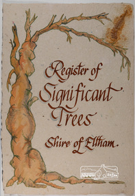 Eltham District Historical Society Inc
Work on paper - Folio, Register of Significant Trees, Shire of Eltham, c.1993
... arthurs creek road, blue gum (eucalyptus globulus), canary island pine (pinus canariensis), couties road, donaldsons oak, donaldsons road, eltham, english oak (quercus robur), eucalyptus melliodora, graysharps road, hurst tree, hurstbridge, ironbark (eucalyptus tricarpa), ironbark hill, kangaroo ground, kangaroo ground-kinglake road, laughing waters road, panton hill hotel, panton hill, parsons road, significant trees register, sonia van bodegraven, sonjart, stone pine (pinus pinea). atlantic cedar (cedrus atlantica), wippells oak, yellow box gum (eucalyptus melliodora), yellow box gum...), Pinus pinea, (Stone pine) and Cedras altlantica, (Cedar) These trees are located at the Hurst family graves in the grounds of the Hurstbridge Pre-school Centre. ...), Pinus pinea, (Stone pine) and Cedras altlantica, (Cedar) These trees are located at the Hurst family graves in the grounds of the Hurstbridge Pre-school Centre. ...In 1983, the National Trust advised the Shire of Eltham that it was investigating a number of trees within the shire which had been nominated for recording the Register of Significant Trees of Victoria. The trees involved were described in the Shire of Eltham Historical Society Newsletter No. 29, March 1983 as follows:- 1. Eucalyptus melliadora (Yellow box) . a) An outstanding mature specimen 42 metres high in Laughing Waters Road, Eltham. b) Another mature specimen in Arthurs Creek road, Hurstbridge is reported to be the tree under which the bushranger Robert Bourke was tied after he shot and killed Henry Hurst in 1866 . 2. Quercus robur (English Oak). a) "Donaldson's Oak", Donaldsons Road, Kangaroo Ground was planted by John Donaldson from seed collected from Windsor Great Park in 1878. b) "Wippells Oak". This now misshapen tree is located on the St. Andrews Road near the Kangaroo Ground Fire Station. Its origins may have been similar to Donaldson's Oak, and as a young tree it apparently slipped from higher up the hill during wet weather. Both oaks are of local historical importance. 3. Eucalyptus globulus (Blue Gum). A large mature specimen at the corner of the Kangaroo Ground-St. Andrews Road and Bakehouse Road, Panton Hill. 4. Plantanas acerifolia (Plane tree) A number of trees forming the Avenue of Honour to Eltham's First World War soldiers along Main Road between Dalton and Pitt Streets, Eltham. 5. Pinus canariensis (Canary Island Pine), Pinus pinea, (Stone pine) and Cedras altlantica, (Cedar) These trees are located at the Hurst family graves in the grounds of the Hurstbridge Pre-school Centre. In 1991 the Shire of Eltham introduced controls into its planning scheme to protect sites of architectural, historic or conservation interest and significant trees. The controls were approved by the Minister for Planning and Housing. As advised in the Shire of Eltham Historical Society Newsletter No. 78, May 1991, a planning permit is required to demolish or alter any listed building or to destroy, lop or remove any listed tree. Provision is made for comments to be obtained from the National Trust or Historic Buildings Council in considering any applications. The buildings and trees listed were: Buildings: 250 Bolton Street Eltham (former Walter Withers home) "Rosehill" - Bonds Road Lower Plenty St Andrews Church of England - St Andrews "Montsalvat" - Hillcrest Avenue Eltham St Margarets Church and former vicarage - Pitt Street Eltham Presbyterian Church - Kangaroo Ground Parks and Environment Office (former police quarters) Main Road Eltham Former Court House - Main Road Eltham "Shillinglaw Cottage" - Main Road Eltham "The Robins" - Kangaroo Ground Road Warrandyte Trees: "Donaldsons Oak" - Donaldsons Road Kangaroo Ground Yellow Box - Laughing Waters Road Eltham Yellow Box - Arthurs Creek Road Hurstbridge Wippells Oak - St Andrews Road Kanqaroo Road Pines and Cedar - Hurst family cemetery Greysharps Road Hurstbridge Yellow Box - Parsons Road Eltham A large Blue Gum at Panton Hill has been listed but has recently died (1991). In 1993 work by Council Parks and Environment staff and volunteers resulted in the preparation of a Significant Tree Register listing forty-one trees or groups of trees. According to Shire of Eltham Historical Society Newsletter No. 91, March 1993, a similar number remained to be assessed for inclusion in the register. There is a wide range of indigenous and planted trees on private and public land and extending through the Shire of Eltham from Lower Plenty to Kinglake. Most can be viewed from publicly accessible locations. The Significant Tree Register lists 41 trees or groups of trees throughout the Shire. It contains a wide range of naturally occurring and planted trees. They have been assessed according to eleven criteria including size, age, rarity, historical value and the like. The list includes large old Red Gums at Lower Plenty, historic Oaks at Kangaroo Ground and Mountain Ash at Kinglake. The register includes a set of slides showing each tree. Garry Bartlett of the Council's Parks and Environment Section and Faye Shepherd were extensively involved in establishment of the register (Newsletter No. 93, November 1993). In 1999 Niliumbik planners prepared an amendment to the Planning Scheme to provide protection for approximately 200 of the places listed in the heritage studies and also in the Significant Tree Register commenced by the Eltham Council (Eltham District Historical Society Newsletter No. 127, July 1999. In 2004, The Register of Significant Trees was presented to the Eltham District Historical Society by Nillumbik Shire Council as part of a wider collection of of its memorabilia of the former Eltham Shire Council (EDHS Newsletter No. 159, July 2004. Album of loose handmade paper sheets contained within a handmade slip cover constructed of handcrafted card with encapsulated flora material (flowers, vines, ferns) and tinted. Each page also contains an embedded/adhered fern leaf also tinted with lacqueur or similar, text as appropriate in ink by hand calligraphy. Each page also has a white protective sheet cut to size and adhered to back surface with sticky tape and folded over face of page. Pages variously have photographs and coloured masks adhered with a gum resin. Over time much of this resin has let go and photos/masks have been reattached using acid free archival safe adhesive. 15 pages 41 x 29 cm inclusive of 3 blank pages. Slip case 42 x 30 x 1 cm; face cover of slip case has broken off at left hand margin as insufficient depth/flexibility for contents.arthurs creek road, blue gum (eucalyptus globulus), canary island pine (pinus canariensis), couties road, donaldsons oak, donaldsons road, eltham, english oak (quercus robur), eucalyptus melliodora, graysharps road, hurst tree, hurstbridge, ironbark (eucalyptus tricarpa), ironbark hill, kangaroo ground, kangaroo ground-kinglake road, laughing waters road, panton hill hotel, panton hill, parsons road, significant trees register, sonia van bodegraven, sonjart, stone pine (pinus pinea). atlantic cedar (cedrus atlantica), wippells oak, yellow box gum (eucalyptus melliodora), yellow box gum -
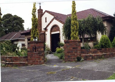 Glen Eira Historical Society
Photograph, Beauville Avenue, 34, Murrumbeena, 2001
... trees cast iron work door Colour photograph of white rendered, corner house with unpainted variegated brown brick features. Other features include a wide arched porch, tiled roof, tall brick chimney, cast iron work black porch door, window awnings and low unpainted matching brick fence in the foreground with "34" on the white metal letterbox on top of the right brick pillar beside the concrete pathway leading to the porch. Well-established garden including 2 matching pencil pines ...Originally labelled "Beauville Estate, Established 1936, Still Thriving 65 years on, 10th March 2001", the Beauville Estate Album contains colour photographs of houses in the Estate. They were taken around the time of the Beauville Estate’s 65th Heritage Celebration held on 10/03/2001 and donated to the Caulfield Historical Society shortly afterwards. Photographer unknown.City of Glen Eira’s Heritage Management Plan Vol 2 p79 (this is p84 of the pdf version) – HO12 Beauville Estate and environs, Murrumbeena: The Beauville Historic Area is important at the State level as the first large housing estate undertaken by the AV Jennings Construction Co, later Jennings Group Limited, Victoria’s largest home builder. It is important also as a very early estate development incorporating a range of features other than houses and including made roads, shops and recreation facilities. In this respect it was the forerunner of the comprehensively planned housing estate of the post war era. The estate is distinguished by its aesthetic values, as is the earlier and comparable Hillcrest Estate, which are formed by a combination of restrained diversity in house styles, with the exception of no. 30 in the emerging International style, and by a landscaped garden environment. Colour photograph of white rendered, corner house with unpainted variegated brown brick features. Other features include a wide arched porch, tiled roof, tall brick chimney, cast iron work black porch door, window awnings and low unpainted matching brick fence in the foreground with "34" on the white metal letterbox on top of the right brick pillar beside the concrete pathway leading to the porch. Well-established garden including 2 matching pencil pines.murrumbeena, houses, beauville avenue, architectural styles, 1930's, inter war style, a.v. jennings, av jennings, jennings, brick houses, beauville estate, porches, sir albert victor jennings, a v jennings construction co, beauville estate heritage area, glen eira city council, architectural features, jennings group limited, land subdivision, gardens, beauville historic area, rendered houses, corner houses, brick features, awnings, brick fences, metal letterboxes, trees, cast iron work door -
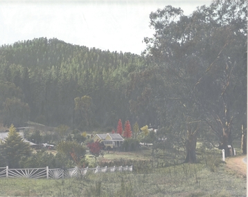 Bendigo Historical Society Inc.
Photograph - HOUSE IN LANDSCAPE VIEW, 1960's ?
... trees. Photo appears to have been taken at Daylesford or Hepburn Springs. House is small cottage, set in front of pine forest rising on hill to rear. ...trees. Photo appears to have been taken at Daylesford or Hepburn Springs. House is small cottage, set in front of pine forest rising on hill to rear. ...Hand tinted photo: photo of house in rural setting with autumn toned trees. Photo appears to have been taken at Daylesford or Hepburn Springs. House is small cottage, set in front of pine forest rising on hill to rear. Large eucalypts on right with road just evident on extreme right of photo.F. T. Kennedyplace, building, rural cottage