Showing 507 items
matching st georges road
-
 Kew Historical Society Inc
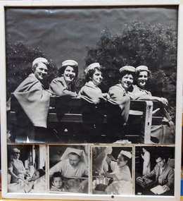
Photograph - Photographs, St George's Hospital, Staff of St George's Hospital, Cotham Road
... Photographs Photograph Staff of St George's Hospital, Cotham Road ...St George's Health Service was established in 1912 by an order of Church of England nuns, the Sisters of the Holy Name. In 1949, the Hospital was sold to the Victorian government. For many years, St George's Health Service was known for expertise in maternity, acute medical and surgical services. From 1991, St George's Health Service began developing aged care services. From 1996 to 1998 the acute medical, surgical and maternity services were transferred to other facilities. From early 1999, St George's Health Service provided solely specialised aged care services. St George's Health Service became part of St Vincent's in March 2001, under an auspice arrangement with the Victorian government. Prior to this, the Service was part of the Inner & Eastern Health Care Network.Unframed panel containing a collage of one large and four smaller photographs assembled to support St George’s Hospital. Individuals photographed are unnamed.st george's hospital - kew, promotional materials -
 Kew Historical Society Inc
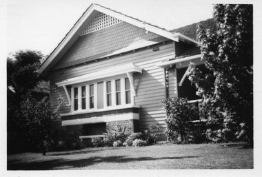
Photograph - 'Fernhurst', 13 Fernhurst Grove, 1978
George Wharton arrived in Melbourne in 1844. An architect and surveyor, he was appointed to lay out the 'Village of Kew' by N.A. Fenwick following the land sales of 1851. A protagonist for Kew's separation from the Boroondara District Road Board, he was elected chairman when Kew achieved municipal status in December 1860. His home, 'Fernhurst', was built in 1866 on eight acres in Studley Park, with a four-storey tower and pyramidal roof. The Italianate home was a prominent Kew landmark. It was demolished in 1979 and replaced by St Paul's College in 1980.Rare colour photograph of what was once a significant mansion in Kew.Original colour positive photograph (Kodak print) of 'Fernhurst' in 1978. Photographed by Stewart West in May 1978, one year before it was demolished, the photograph gives little idea of the large landholding once surrounding the house. Originally accessed from near the corner of Princess Street and Studley Park Road, its gardens had been subdivided in the 1900s and its footprint restricted to 13 Fernhurst Grove. Like many other grand houses, by the 1970s it had been converted into apartments. From the photograph, one can see that the house had retained many of its original features such as the distinctive tower and the wide bow-fronted verandah. The slates on the roof (apart from those on the tower) had been replaced by tiles and the cement render of the exterior painted white. Annotated reverse: "View of Fernhurst Home Taken from Street / 10"fernhurst, 13 fernhurst grove -- kew (vic.), george wharton, italianate architecture, vila maria society, st paul's school for the blind -
 Kew Historical Society Inc
Photograph - 'Fernhurst', 13 Fernhurst Grove, 1978
George Wharton arrived in Melbourne in 1844. An architect and surveyor, he was appointed to lay out the 'Village of Kew' by N.A. Fenwick following the land sales of 1851. A protagonist for Kew's separation from the Boroondara District Road Board, he was elected chairman when Kew achieved municipal status in December 1860. His home, 'Fernhurst', was built in 1866 on eight acres in Studley Park, with a four-storey tower and pyramidal roof. The Italianate home was a prominent Kew landmark. It was demolished in 1979 and replaced by St Paul's College in 1980.Rare colour photograph of what was once a significant mansion in Kew.Original colour positive photograph (Kodak print) of 'Fernhurst' in 1978. Photographed by Stewart West in May 1978, one year before it was demolished, the photograph gives little idea of the large landholding once surrounding the house. Originally accessed from near the corner of Princess Street and Studley Park Road, its gardens had been subdivided in the 1900s and its footprint restricted to 13 Fernhurst Grove. Like many other grand houses, by the 1970s it had been converted into apartments. From the photograph, one can see that the house had retained many of its original features such as the distinctive tower and the wide bow-fronted verandah. The slates on the roof (apart from those on the tower) had been replaced by tiles and the cement render of the exterior painted white. Annotated reverse: "Fernhurst from higher ground level side shot / 7"fernhurst, 13 fernhurst grove -- kew (vic.), george wharton, italianate architecture, vila maria society, st paul's school for the blind -
 Kew Historical Society Inc
Photograph - 'Fernhurst', 13 Fernhurst Grove, 1978
George Wharton arrived in Melbourne in 1844. An architect and surveyor, he was appointed to lay out the 'Village of Kew' by N.A. Fenwick following the land sales of 1851. A protagonist for Kew's separation from the Boroondara District Road Board, he was elected chairman when Kew achieved municipal status in December 1860. His home, 'Fernhurst', was built in 1866 on eight acres in Studley Park, with a four-storey tower and pyramidal roof. The Italianate home was a prominent Kew landmark. It was demolished in 1979 and replaced by St Paul's College in 1980.Rare colour photograph of what was once a significant mansion in Kew.Original colour positive photograph (Kodak print) of 'Fernhurst' in 1978. Photographed by Stewart West in May 1978, one year before it was demolished, the photograph gives little idea of the large landholding once surrounding the house. Originally accessed from near the corner of Princess Street and Studley Park Road, its gardens had been subdivided in the 1900s and its footprint restricted to 13 Fernhurst Grove. Like many other grand houses, by the 1970s it had been converted into apartments. From the photograph, one can see that the house had retained many of its original features such as the distinctive tower and the wide bow-fronted verandah. The slates on the roof (apart from those on the tower) had been replaced by tiles and the cement render of the exterior painted white. Annotated reverse: "Back view of Fernhurst / 8"fernhurst, 13 fernhurst grove -- kew (vic.), george wharton, italianate architecture, vila maria society, st paul's school for the blind -
 Kew Historical Society Inc
Photograph - 'Fernhurst', 13 Fernhurst Grove, 1978
George Wharton arrived in Melbourne in 1844. An architect and surveyor, he was appointed to lay out the 'Village of Kew' by N.A. Fenwick following the land sales of 1851. A protagonist for Kew's separation from the Boroondara District Road Board, he was elected chairman when Kew achieved municipal status in December 1860. His home, 'Fernhurst', was built in 1866 on eight acres in Studley Park, with a four-storey tower and pyramidal roof. The Italianate home was a prominent Kew landmark. It was demolished in 1979 and replaced by St Paul's College in 1980.Rare colour photograph of what was once a significant mansion in Kew.Original colour positive photograph (Kodak print) of 'Fernhurst' in 1978. Photographed by Stewart West in May 1978, one year before it was demolished, the photograph gives little idea of the large landholding once surrounding the house. Originally accessed from near the corner of Princess Street and Studley Park Road, its gardens had been subdivided in the 1900s and its footprint restricted to 13 Fernhurst Grove. Like many other grand houses, by the 1970s it had been converted into apartments. From the photograph, one can see that the house had retained many of its original features such as the distinctive tower and the wide bow-fronted verandah. The slates on the roof (apart from those on the tower) had been replaced by tiles and the cement render of the exterior painted white. Annotated reverse: "Fernhurst front view taken from across Fernhurst Grove / 6"fernhurst, 13 fernhurst grove -- kew (vic.), george wharton, italianate architecture, vila maria society, st paul's school for the blind -
 Kew Historical Society Inc
Photograph - 'Fernhurst', 13 Fernhurst Grove, 1978
George Wharton arrived in Melbourne in 1844. An architect and surveyor, he was appointed to lay out the 'Village of Kew' by N.A. Fenwick following the land sales of 1851. A protagonist for Kew's separation from the Boroondara District Road Board, he was elected chairman when Kew achieved municipal status in December 1860. His home, 'Fernhurst', was built in 1866 on eight acres in Studley Park, with a four-storey tower and pyramidal roof. The Italianate home was a prominent Kew landmark. It was demolished in 1979 and replaced by St Paul's College in 1980.Rare colour photograph of what was once a significant mansion in Kew.Original colour positive photograph (Kodak print) of 'Fernhurst' in 1978. Photographed by Stewart West in May 1978, one year before it was demolished, the photograph gives little idea of the large landholding once surrounding the house. Originally accessed from near the corner of Princess Street and Studley Park Road, its gardens had been subdivided in the 1900s and its footprint restricted to 13 Fernhurst Grove. Like many other grand houses, by the 1970s it had been converted into apartments. From the photograph, one can see that the house had retained many of its original features such as the distinctive tower and the wide bow-fronted verandah. The slates on the roof (apart from those on the tower) had been replaced by tiles and the cement render of the exterior painted white. Annotated reverse: "Front view of Fernhurst showing tower to advantage / 9"fernhurst, 13 fernhurst grove -- kew (vic.), george wharton, italianate architecture, vila maria society, st paul's school for the blind -
 Kew Historical Society Inc
Photograph - 'Fernhurst', 13 Fernhurst Grove, 1978
George Wharton arrived in Melbourne in 1844. An architect and surveyor, he was appointed to lay out the 'Village of Kew' by N.A. Fenwick following the land sales of 1851. A protagonist for Kew's separation from the Boroondara District Road Board, he was elected chairman when Kew achieved municipal status in December 1860. His home, 'Fernhurst', was built in 1866 on eight acres in Studley Park, with a four-storey tower and pyramidal roof. The Italianate home was a prominent Kew landmark. It was demolished in 1979 and replaced by St Paul's College in 1980.Rare colour photograph of what was once a significant mansion in Kew.Original colour positive photograph (Kodak print) of 'Fernhurst' in 1978. Photographed by Stewart West in May 1978, one year before it was demolished, the photograph gives little idea of the large landholding once surrounding the house. Originally accessed from near the corner of Princess Street and Studley Park Road, its gardens had been subdivided in the 1900s and its footprint restricted to 13 Fernhurst Grove. Like many other grand houses, by the 1970s it had been converted into apartments. From the photograph, one can see that the house had retained many of its original features such as the distinctive tower and the wide bow-fronted verandah. The slates on the roof (apart from those on the tower) had been replaced by tiles and the cement render of the exterior painted white. Annotated reverse: "Fernhurst corner shot through trees / 12-22"fernhurst, 13 fernhurst grove -- kew (vic.), george wharton, italianate architecture, vila maria society, st paul's school for the blind -
 Clayton RSL Sub Branch
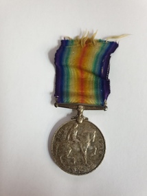
Medal, British War medal
HYAMS, Frederick 17892The ribbon has a wide central watered stripe of orange, flanked by two narrow white stripes, which are in turn flanked by two black pin-stripes, further flanked by two outer stripes of blue. The colours have no particular significance. The medal is cupro-nickel with the effigy of George V on the obverse. The reverse has an image of St George on horseback trampling underfoot the eagle shield of the Central Powers, and a skull and cross-bones, the emblems of death. Above this is the risen sun of victory. The years 1914 and 1918 are contained on the outside edge medal.1914-1918 GEORGIVS BRITT OMN:REX ET IND:IMP: HYAMS, Frederick, Private 17982 -
 Surrey Hills Historical Society Collection
Photograph, Centenary Movie Snap, Frederick John (Fred) Ambler
Frederick John Ambler was an upholsterer. Married Beatrice Annie Martin in 1897. Fred was born in Essex, UK in 1873. The Amblers has a large family: Gordon Frederick William (1898-1910); Malcolm George (1900-1965); Daisy May (1904-1904); Leon Verde (1904-1904); Garnet Leslie (1904-1904); Ruby Isobel (1906-2004); Hector Leon (1909-1994); Sylvia Beatrice (1912 - ); Daisy May (1914-2009); Ronald Edward (1915-1990); Jean Mavis (1918-2001) plus Dorothy (dates not known). Residence: 1900-1914: 59 Sunbury Crescent; 1914-1950): 362 Canterbury Road (residence and workshop) in the Hansen's Terrace. Fred died at home (362 Canterbury Road) on 27 December 1947. He is buried in Box Hill Cemetery - M-201-0035 along with his wife. Beatrice's parents lived at 18 Lorne Parade, Surrey Hills. Black and white formal portrait of Fred Ambler in a dark suit."MRS. D. CARLSON / 1/80 WATTS ST/ BOX HILL NTH / 898 3621" Separately "FRED AMBLER" Also stamped with the photographer's details.frederick john ambler, 362 canterbury road, 59 sunbury crescent, mrs beatrice annie ambler, miss beatrice annie martin, fred ambler, box hill cemetery -
 Surrey Hills Historical Society Collection
Photograph, Alpha Photo Services, Frederick John (Fred) Ambler and his wife Beatrice Annie (nee Martin)
Frederick John Ambler was an upholsterer. Married Beatrice Annie Martin in 1897. Fred was born in Essex, UK in 1873. The Amblers has a large family: Gordon Frederick William (1898-1910); Malcolm George (1900-1965); Daisy May (1904-1904); Leon Verde (1904-1904); Garnet Leslie (1904-1904); Ruby Isobel (1906-2004); Hector Leon (1909-1994); Sylvia Beatrice (1912 - ); Daisy May (1914-2009); Ronald Edward (1915-1990); Jean Mavis (1918-2001) plus Dorothy (dates not known). Residence: 1900-1914: 59 Sunbury Crescent; 1914-1950): 362 Canterbury Road (residence and workshop) in the Hansen's Terrace. Fred died at home (362 Canterbury Road) on 27 December 1947. He is buried in Box Hill Cemetery - M-201-0035 along with his wife. Beatrice's parents lived at 18 Lorne Parade, Surrey Hills. Small black and white square portrait of Fred and Annie Ambler against a paling fence."ANNIE & FRED/ AMBLER/ D. CARLSON / 1/80 WATTS ST/ BOX HILL NTH / 898 3621" Also stamped with "2241" plus "ALPHA / PHOTO SERVICES/ BOX HILL"frederick john ambler, 362 canterbury road, 59 sunbury crescent, mrs beatrice annie ambler, miss beatrice annie martin, fred ambler, box hill cemetery -
 Surrey Hills Historical Society Collection
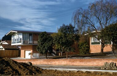
Digital photo, George L Coop, 688 Whitehorse Road, Mont Albert c 1953, c1953
This was the home of 3 generations of the Coop family: 1. Josephine and George Frank Coop (noted in Box Hill Rate Books for 1947-1954). 2. George Burton Coop (1906-1960) and his family. He was Assistant Chief Architect of Victoria in the Public Works Department (P.W.D.) George Burton Coop was born in c1906 in Williamstown, the son of Josephine Vistarini and George Frank Coop. He married Winifred Alice Trewartha in 1936 and they are listed in the electoral rolls at 688 Whitehorse Road in 1937. George died 3/4/1960, aged 54 years at Mont Albert. 3. George Burton and Alice Coop had 2 children: George Lister Coop - born St Georges Hospital, 8/10/1937 Alison - born c1945. The donor George Lister Coop informed that he initially attended Chatham State School because his first home was the Spanish Mission style flats at 346 Whitehorse Road, opposite Brenbeal Street, Balwyn. When his grandparents died, the family moved to 688 Whitehorse Road and he then attended Mont Albert Central School. The California bungalow style of housing was the dominant style of housing built in the interwar period through the northern parts of Surrey Hills and Mont Albert as formerly semi-rural land was subdivided for new housing. It was relatively inexpensive and affordable. In Australia the Californian bungalow drew upon elements that were popular across the United States from around 1910 to 1939. In Australia the style became popular from 1913. In Melbourne both timber and red brick were used as the main building material. Typically they are one or one and a half story houses and feature sloping roofs and eaves with unenclosed rafters and often a feature a dormer window (or an attic vent designed to look like one) over the main portion of the house. Decorative elements include wood shingles, part stucco rendered exteriors, brick, stone, rendered or a combination of these treatments to exterior chimneys and front porches supported by heavy timber, brick or stucco columns.A black & white photo taken at an angle of a Californian bungalow.californian bungalow, whitehorse road, george frank coop, (miss) josephine vistarini, (mrs) josephine coop, george burton coop, (miss) winifred trewartha, (mrs) winifred coop, george lister coop, alison coop -
 Surrey Hills Historical Society Collection
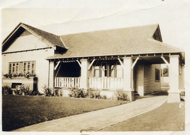
Digital photo, George L Coop, 688 Whitehorse Rd. Mont Albert c1950, c1950
This was the home of 3 generations of the Coop family: 1. Josephine and George Frank Coop (noted in Box Hill Rate Books for 1947-1954). 2. George Burton Coop (1906-1960) and his family. He was Assistant Chief Architect of Victoria in the Public Works Department (P.W.D.) George Burton Coop was born in c1906 in Williamstown, the son of Josephine Vistarini and George Frank Coop. He married Winifred Alice Trewartha in 1936 and they are listed in the electoral rolls at 688 Whitehorse Road in 1937. George died 3/4/1960, aged 54 years at Mont Albert. 3. George Burton and Alice Coop had 2 children: George Lister Coop - born St Georges Hospital, 8/10/1937 Alison - born c1945. The donor George Lister Coop informed that he initially attended Chatham State School because his first home was the Spanish Mission style flats at 346 Whitehorse Road, opposite Brenbeal Street, Balwyn. When his grandparents died, the family moved to 688 Whitehorse Road and he then attended Mont Albert Central School. The California bungalow style of housing was the dominant style of housing built in the interwar period through the northern parts of Surrey Hills and Mont Albert as formerly semi-rural land was subdivided for new housing. It was relatively inexpensive and affordable. In Australia the Californian bungalow drew upon elements that were popular across the United States from around 1910 to 1939. In Australia the style became popular from 1913. In Melbourne both timber and red brick were used as the main building material. Typically they are one or one and a half story houses and feature sloping roofs and eaves with unenclosed rafters and often a feature a dormer window (or an attic vent designed to look like one) over the main portion of the house. Decorative elements include wood shingles, part stucco rendered exteriors, brick, stone, rendered or a combination of these treatments to exterior chimneys and front porches supported by heavy timber, brick or stucco columns.A sepia photo taken at an angle from the street corner of the property. It is of a Californian bungalow with a driveway that extends through a carport, attached and roofed as part of the house, to the rear of the property. The veranda is accessed from under this covered area. The veranda and carport are supported by brick pillars and the veranda balustrades between are plain with an occasional wider feature panel. The front door is in shadow. There are rolled up striped canvas blinds on the veranda and at least 2 cane chairs. The main structure of the house is weatherboard with a terracotta tiled roof. There is a flower bed across the front of the house with an elevated brick flower box under the main window. There are no chimneys visible.californian bungalow, whitehorse road, george frank coop, (miss) josephine vistarini, (mrs) josephine coop, george burton coop, (miss) winifred trewartha, (mrs) winifred coop, george lister coop, alison coop -
 Surrey Hills Historical Society Collection
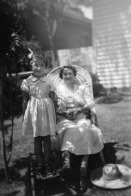
Digital photo, George L Coop, Winifred Alice Coop and her daughter Alison, c1950
The photo was taken at 688 Whitehorse Road, Mont Albert. It is of Winifred Alice Coop (nee Trewartha), known as Alice, and her daughter Alison, b1945. This was the home of 3 generations of the Coop family: 1. Josephine and George Frank Coop (noted in Box Hill Rate Books for 1947-1954). 2. George Burton Coop (1906-1960) and his family. He was Assistant Chief Architect of Victoria in the Public Works Department (P.W.D.) George Burton Coop was born in c1906 in Williamstown, the son of Josephine Vistarini and George Frank Coop. He married Winifred Alice Trewartha in 1936 and they are listed in the electoral rolls at 688 Whitehorse Road in 1937. George died 3/4/1960, aged 54 years at Mont Albert; Alice died in 1980. 3. George Burton and Alice Coop had 2 children: George Lister Coop - born St Georges Hospital, 8/10/1937 Alison - born c1945. The donor George Lister Coop informed that he initially attended Chatham State School because his first home was the Spanish Mission style flats at 346 Whitehorse Road, opposite Brenbeal Street, Balwyn. When his grandparents died, the family moved to 688 Whitehorse Road and he then attended Mont Albert Central School. Alison being younger did not go to Chatham Primary. A black & white photo of a woman seated in a cane chair with her daughter standing adjacent to her and standing on a small child's chair. The woman's sun hat is lying beside her on the grass. Both faces are partly shaded by an adjacent bush.alison coop, (mrs) winifred alice coop, whitehorse road, surrey hills, children, clothing and dress, george lister coop -
 Surrey Hills Historical Society Collection
Photograph - Digital photograph, George L Coop, 692-694 Whitehorse Road Mont Albert, 1958, c1958
The donor George Lister Coop was about 21 years of age when he took this photo in 1958. This photo is of Annesley Home for the Aged at 692-694 Whitehorse Road. It was originally a Methodist, later a Uniting Church facility. The new section in the photo was part of an extension built in 1958. The Queen Anne / Edwardian brick attic home was built in c1908 for William Pilkington, a manufacturer and was called 'St Martins'. Ownership stayed in this family until c1950. A new brick veneer 2 storey building sits adjacent to a red brick Edwardian home. Elderly-looking people can be seen sitting behind the window of the new section.george l coop, whitehorse road, mont albert, annesley home for the aged, uniting church, st martins, pilkington family -
 Surrey Hills Historical Society Collection
Photograph - Digital photograph, George L Coop, 692-694 Whitehorse Road Mont Albert, 1958
The donor George Lister Coop was about 21 years of age when he took this photo in 1958. This photo is of Annesley Home for the Aged at 692-694 Whitehorse Road. It was originally a Methodist, later a Uniting Church facility. The new sections in the photo was part of an extension built in 1958. A further extension encompassing 21 beds occurred in 1971. A Queen Anne / Edwardian brick attic home was built on No 694 in 1908 for William Pilkington, a manufacturer and was called 'St Martins'. Ownership stayed in this family until c1950. It was retained as part of the facility. Alan Holt's register of 3127 properties list 34 residents in 1980, of which all but 3 were female. The property was replaced by apartments in c2018 but had ceased function as a nursing home quite a number of years prior to this and in the interim appeared to be used for temporary accommodation. A street view of new brick veneer 2 storey extensions to Annesley Home for the Aged. It does not show the original home 'St Martin's' that the facility was built around. In the foreground the pile of soil relates to the excavation works undertaken in widening Whitehorse Road.george l coop, whitehorse road, mont albert, annesley home for the aged, uniting church, st martins, pilkington family -
 Surrey Hills Historical Society Collection
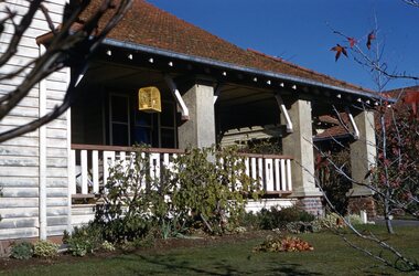
Photograph - Digital photograph, George L Coop, 688 Whitehorse Road, Mont Albert 1958, 1958
The donor George Lister Coop was about 21 years of age when he took this photo in 1958 of his family home. His parents were George Burton Coop (b c1906 Williamstown; died aged 54 years at Mont Albert) and Winsome Alice (MS: Trewartha) who married in 1936. They are first listed at this address in the electoral roll in 1937. They had 2 children: George Lister Coop - born St Georges Hospital, 8/10/1937 and Alison - born c1945. However the donor informed that he initially attended Chatham State School because his first home was the Spanish Mission style flats at 346 Whitehorse Road, opposite Brenbeal Street, Balwyn. When his grandparents died, the family moved to 688 Whitehorse Road and he then attended Mont Albert Central School. Alison being younger did not go to Chatham Primary. A digital copy of a colour photo showing detail of the front veranda of 688 Whitehorse Road. The house is white weatherboard in a modified Californian bungalow style with a tiled roof and the carport built within the roofline. The balustrades and finials of the veranda are simple with occasional feature planks with a tulip detail. A bird cage hangs from the veranda. The veranda is supported by rough-cast sturdy pillars.george l coop, whitehorse road, mont albert, uniting church, californian bungalow -
 Surrey Hills Historical Society Collection
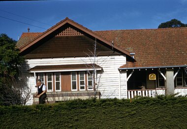
Photograph - Digital photograph, George L Coop, 688 Whitehorse Road, Mont Albert 1958, 1958
The gentleman in the photo is George Burton Coop, an architect / draughtsman. The donor, his son George Lister Coop was about 21 years of age when he took this photo in 1958 of his family home. His parents were: George Burton Coop (b c1906 Williamstown; died aged 54 years at Mont Albert) and Winsome Alice (MS: Trewartha) who married in 1936. They are first listed at this address in the electoral roll in 1937. They had 2 children: George Lister Coop - born St Georges Hospital, 8/10/1937 and Alison - born c1945. However the donor informed that he initially attended Chatham State School because his first home was the Spanish Mission style flats at 346 Whitehorse Road, opposite Brenbeal Street, Balwyn. When his grandparents died, the family moved to 688 Whitehorse Road and he then attended Mont Albert Central School. Alison being younger did not go to Chatham Primary. A digital copy of a colour photo showing detail of the front view of 688 Whitehorse Road. The house is white weatherboard in a Californian bungalow style with a tiled roof and shingles detail in a dark brown stain. The balustrades and finials of the veranda are simple with occasional feature planks with a tulip detail. A bird cage hangs from the veranda. The veranda is supported by rough-cast sturdy pillars. The house sits behind a cypress hedge. The photo was taken in winter as deciduous shrubs are bare. A gentleman astride a ladder is pruning the hedge. george l coop, whitehorse road, mont albert, californian bungalow, cypress hedge, gardening, george burton coop -
 Surrey Hills Historical Society Collection
Photograph, Holy Trinity Church, Surrey Hills in the 1920s
This church was built in 1907 and became known as Holy Trinity Surrey Hills. This name had previously been used by the Anglican Church in Mont Albert Road, Mont Albert. This henceforth became known as St George's Anglican Church, Mont Albert. There are 2 copies: the original donated print and an enlargement. The original is mounted on card with photo mounts along with 890, 891 and 892. It measures 13 cm x 9 cm. Norman Carter took many photos of Surrey Hills and Mont Albert from the 1920s in particular of events and activities associated with the Church of England.Black and white photo of the original Holy Trinity Church building in Union Road. It is constructed of weatherboards, above which there is plasterboard and timber strapping. The roof is of terracotta tiles with a small steeple at the front and a larger one towards the rear of the building. There is a box bay window at the front and the entrance is from a porch on the southern side of the building. This is approached by stairs. Part of the vicarage can be seen on the northern high side of the church and to the south there is vacant land. The whole property sits behind a simple post and wire fence. There is a phaeton in the foreground beside a relatively newly planted street tree. The road has bluestone kerb and channelling.churches, holy trinity church, anglican church, horse-drawn vehicles, norman brodley carter, union road -
 Surrey Hills Historical Society Collection
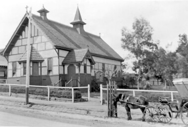
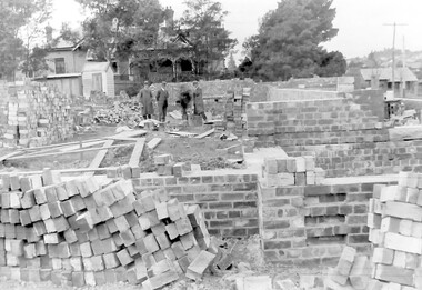
Photograph, Holy Trinity Church of England, Surrey Hills during construction, 1922
St George's Church of England, Mont Albert was built in 1886 and from 1904 until 1907 was known as Holy Trinity, Surrey Hills. As the population increased there was a need for a church in Surrey Hills. This brick church was consecrated in 1922 and replaced the earlier one built in 1907 on the adjacent site in Union Road. The house behind the church at 1 Montrose Street belonged to Mr W B Vine. There are 2 copies: the original donated print and an enlargement. The original is mounted on card with photo mounts along with 884, 885, 886 and 512. It measures 13 cm x 9 cm. Norman Carter took many photos of Surrey Hills and Mont Albert in the 1920s; many were associated with events and activities of the Church of England.Black and white photo of 3 men inspecting the construction site of the Holy Trinity Church of England in Union Road, Surrey Hills. The foundations are surrounded by piles of bricks. In the background is a small timber shed and beyond that a timber Edwardian home partly hidden by foliage.churches, holy trinity church, anglican church, building construction, montrose street, w b vine -
 Surrey Hills Historical Society Collection
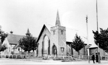
Photograph, Holy Trinity Church of England, Surrey Hills post 1926, After 1926
... on both sides of Union Road. St George's Church of England, Mont ...St George's Church of England, Mont Albert was built in 1886 and from 1904 until 1907 was known as Holy Trinity, Surrey Hills. As the population increased there was a need for a church in Surrey Hills. This brick church was consecrated in 1922 and replaced the earlier one built in 1907 on the adjacent site in Union Road. After construction of the brick church, the earlier one became a Sunday School. The copper spire was added in 1926, which dates this photo as post-1926. Norman Carter took many photos of Surrey Hills and Mont Albert in the 1920s; many were associated with events and activities of the Church of England.Black and white photo of the 'newly' constructed brick Holy Trinity Church in Union Road, Surrey Hills taken from near the south-west corner of Guildford Road. Further up the hill is the earlier church. Both buildings are bounded by a simple post and rail fence. Immature street trees are planted on both sides of Union Road.churches, holy trinity church, anglican church, sunday schools, norman carter -
 Kew Historical Society Inc
Plan, Melbourne & Metropolitan Board of Works : Borough of Kew : Detail Plan No.1591, 1905
The Melbourne and Metropolitan Board of Works (MMBW) plans were produced from the 1890s to the 1950s. They were crucial to the design and development of Melbourne's sewerage and drainage system. The plans, at a scale of 40 feet to 1 inch (1:480), provide a detailed historical record of Melbourne streetscapes and environmental features. Each plan covers one or two street blocks (roughly six streets), showing details of buildings, including garden layouts and ownership boundaries, and features such as laneways, drains, bridges, parks, municipal boundaries and other prominent landmarks as they existed at the time each plan was produced. (Source: State Library of Victoria)This plan forms part of a large group of MMBW plans and maps that was donated to the Society by the Mr Poulter, City Engineer of the City of Kew in 1989. Within this collection, thirty-five hand-coloured plans, backed with linen, are of statewide significance as they include annotations that provide details of construction materials used in buildings in the first decade of the 20th century as well as additional information about land ownership and usage. The copies in the Public Record Office Victoria and the State Library of Victoria are monochrome versions which do not denote building materials so that the maps in this collection are invaluable and unique tools for researchers and heritage consultants. A number of the plans are not held in the collection of the State Library of Victoria so they have the additional attribute of rarity.Original survey plan, issued by the MMBW to a contractor with responsibility for constructing sewers in the area identified on the plan within the Borough of Kew. The plan was at some stage hand-coloured, possibly by the contractor, but more likely by officers working in the Engineering Department of the Borough and later Town, then City of Kew. The hand-coloured sections of buildings on the plan were used to denote masonry or brick constructions (pink), weatherboard constructions (yellow), and public buildings (grey). That area of Kew bordered by Cotham Road, Park Hill Road, Ermington Lane (now Ermington Place), and Belmont Avenue contained some of the significant homes owned by Kew pioneers. Chief among these was ‘Park Hill’ on an enormous lot facing Park Hill Road. The Jubilee History of 1910 noted, six years after this plan was drawn, that: ‘Park Hill Road, forming the southern boundary of the cemetery, takes its name from Park Hill, the residence of Mr. Thomas Judd, who has resided there since December, 1852.’ Other named houses on the plan include ‘Ferndale’ facing Cotham Road; ‘Ermington’ adjacent to Judd’s Park Hill, facing Park Hill Road; and ‘Gilden’ and ‘Mont Belmont’ facing Belmont Avenue. Mont Belmont was designed by the architectural firm of Reed, Henderson and Smart for William George Lilley in 1887 and was completed in 1888. Lilley was Mayor of Kew in 1887-88, a Justice of the Peace and a member of the first Board of Guardians of Kew’s St. Hilary’s Church of England.melbourne and metropolitan board of works, detail plans, survey plans - borough of kew, mmbw 1591, cartography -
 Whitehorse Historical Society Inc.
Document, Marriage Certificate - William Dugdale, 30/05/1907 12:00:00 AM
Certificate of Marriage of William Dugdale, grazier, and Hannah Louisa Richards at St. George's Church, Blackburn.Certificate of Marriage of William Dugdale, grazier, and Hannah Louisa Richards at St. George's Church, Blackburn.Certificate of Marriage of William Dugdale, grazier, and Hannah Louisa Richards at St. George's Church, Blackburn.dugdale, william, richards, hannah louisa -
Whitehorse Historical Society Inc.
Document, Marriage Certificate - William Edward Williams, 29/12/1909 12:00:00 AM
Certificate of Marriage of William Edward Williams, orchardist, and Ada May Webb at St. George's Church, Middleborough.Certificate of Marriage of William Edward Williams, orchardist, and Ada May Webb at St. George's Church, Middleborough. Certificate of Marriage of William Edward Williams, orchardist, and Ada May Webb at St. George's Church, Middleborough. williams, william edward, webb, ada may -
 Halls Gap & Grampians Historical Society
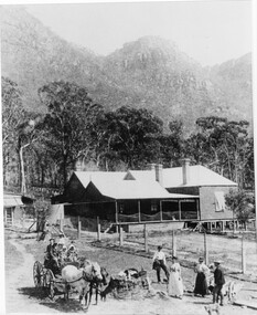
Photograph - B/W, C 1880
1880-1902 Land owned by Robert and Sarah Graham who owned a large portion of land best described as Upper Fyans Valley. At some time after 1880, they sold a parcel of the land under Sundial Peak to David Austin who built a slab hut. C1896, The land was sold to James and Amy Balmain which they named 'Bellfield' Amy was a daughter of John D/Alton who built the Stawell Water Supply System. Balmain purchased the vacant school cottage at Burnt Bridge and moved it to 'Bellfield' Over the next six years the house was enlarged to accommodate their growing family but sold in 1902 following the death of Amy Balmain.House with addition People leaving house by horse and carriage, people standing in groundsState Library Victoria, Rose's Australasian Views Victorian Series photographed and published by George Rose 123 Chapel St., Windsor, Victoriabuildings, houses, bellfield -
 Halls Gap & Grampians Historical Society
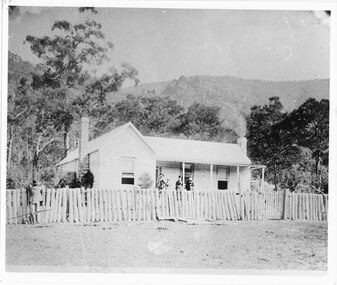
Photograph - B/W, C 1875
1875-1876 The residence of John and Catherine D/Alton built on site of present Colonial Motor Inn. 1900 Owned by Langley family, "Morningside" was now taking in paying guests. 1909 Leased by James and Grace D'Alton who continued to run a small guest house. Late 1920s a small building was erected to serve as PO and telephone exchange. C1980 Guest house closed. 1982 Morningside demolished.Weatherboard house, picket fence 5 people Alexandria and Laura Sheridan, Catherine D/Alton, Meg Sheridan, a man standing at fenceMorningside 1875-76 John D'Alton and 2nd wife Catherine Fulton nee (Denholm), her mother and Aunt Mrs Sheridan original front now the back of Colonial motel Rose'e Australasian Views. Vitorian Series. Photographed and published George Rose, 123 Chapel St Windsor, Victoriabuildings, morningside, people, d'alton -
 Orbost & District Historical Society
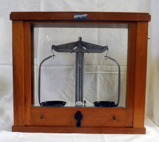
beam balance, second half 20th century 1954-1999
These scales were used by students at St Joseph's School in Orbost. St Joseph's Catholic School in Orbost was planned from 1913 when the town's population was increasing rapidly. It wasn't until 1923 that the school was built in Raymond Street next to St Colman's Church. The Catholic school was opened in thecharge of Sister Moira and Sister Lucy, Fifty-five students were initially enrolled and taught in two rooms. When the numbers increased to 170 work began on extensions which were completed in 1959. St Joseph's school had classes to Form 4 at one stage. Later on Form 2 was the highest level. However, after Nagle College at Bairnsdale built a new school on the Lindenow Road site, a Nagle College school bus ran from Orbost and the school was reduced to Grade 6. It was also about this time that the last of the St Joseph teaching nuns left Orbost. From 1969 to the early 1980s the secondary St Joseph students attended Orbost High School for the practical subjects of Woodwork and Home Economics. Today enrolments reflect the declining population of the district.This item is an example of early school equipment.A set of beam balance scales in a wooden framed cabinet with glass windows on all for sides. The front is a vertical slide which allows acess to the scales. The scales have one fixed leg and two adjustable legs for accurate levelling. GRIFFIN GEORGE LIMITED, LONDON, BIRMINGHAM, MANCHESTER label on front of wooden section of case -ANALITE PTY LTD ASG@W EDINBURGH MADE IN GREAT BRITAIN MINOR REG DES No's 891235 & 891238education science scientific-apparatus measurement -
Warrnambool and District Historical Society Inc.
Booklet, The Blessing of Belief, 1956
This book was written by the Rev. Gordon Powell in 1956. Gordon Powell (1911-2005), the son of George Powell, a Kepler Street dentist, was born in Warrnambool. A minister, writer and broadcaster, the Rev. Gordon Powell was the best-known Presbyterian minister in Australia in the 20th century. He was the minister at the Independent Church, Melbourne for many years and served in New Guinea as a chaplain during World War Two. When minister at St. Stephen’s Church in Sydney he attracted the largest congregation of any Protestant church in Australia at the time at both his Sunday and Wednesday services. He gave radio talks for many years and was responsible for introducing the world-wide group, Alcoholics Anonymous to Australia.This book is retained as it was written by an influential 20th century Australian Presbyterian Minister, the Rev. Gordon Powell. He was born in Warrnambool. This is a hard cover book of 124 pages. The cover is blue with black lettering on the spine. The dust cover has black and blue printing and a photograph on the front of a coastal scene. The spine of the dust cover is torn The pages contain printed material in an introduction and eleven chapters.Godfrey 10 Somers Rd. Warrnamboolrev. gordon powell, history of warrnambool, st. stephen’s church -
Warrnambool and District Historical Society Inc.
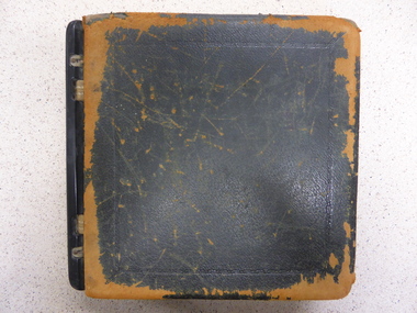
Album, early 20th century
This album contains cut-outs and newspaper illustrations that date mainly from 1915 and 1916. The compiler is mainly interested in animals and agricultural shows etc bu there are also images of World War One deceased soldiers and local Warrnambool cuttings, including some of an Australia Day parade showing the floats. No information has been found on the compiler, George Bennett.This album is of interest, firstly because it is a good example of a young boy's album compiled in early 20th century times and secondly because it has some local content - images not hitherto seen.This is an album with a red cover decorated with mauve and orange flowers and greenery. The pages contain children's cut-outs of animals, mainly horses and dogs, newspaper illustrations and images of World War One deceased soldiers. All the items are pasted in. The edges of the cover are slightly worn and the binding is a little loose. There are some blank pages.George Bennett 1915album with warrnambool cuttings -
 Warrnambool and District Historical Society Inc.
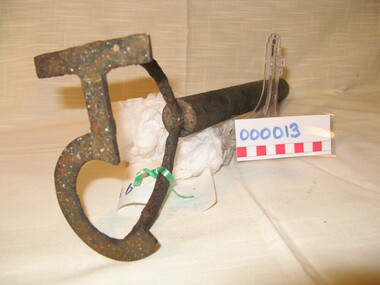
Functional object - Farming Equipment Branding Iron, Circa 1840
Armyne, George and Lemuel Bolden were original landholders of large parts of land in the Western district. Portions of it extended from Pirron Yallock in the East to almost as far as Portland. The head station was at Grasmere. They were noted breeders of shorthorn cattle in fact they were some of the first men to bring the breed to Victoria and thus helped to pioneer the Australian Shorthorn breeding Industry. This branding iron was found at Lyall Park, originally 640 acres selected by William Lyall at Cooramook. It is believed to be a branding iron dating from when the land was occupied by the Bolden Brothers. The Bolden Brothers were the first to erect considerable lengths of fencing in the Warrnambool area. If this item is an authentic Bolden piece of property then it is the oldest artefact from the time of white settlement that is held by the Warrnambool and district Historical society. The item itself while a common farming implement and which was found on a farm originally owned by the Bolden Brothers is a link with the earliest part of Warrnambool’s history.Short, round wooden handle with metal brand in the shape of the letter T with two thirds circle attached to vertical part of T. Daub of paint at end of handle . T 5Paper label attached with green tape with 931 in texta and hand written on back,” branding iron reputed to have been used by Bolden Bros Grasmere c 1840. warrnambool, bolden brothers, armyne bolden, george bolden, lemuel bolden, branding iron, shorthorn cattle -
 Warrnambool and District Historical Society Inc.
Ledger, Mortgagee
This ledger appears to have been a mortgage document held by the law firm of Mackay Taylor and Co. with the evidence for this the presence of two loose sheets of paper in the ledger with that firm’s letterhead. Mackay Taylor was established in 1893 with the merger of the firms of George Sutherland Mackay and James Fletcher, independent practising lawyers at the time. The new firm became Fletcher and Mackay and later changed to Mackay and Taylor when J. McD. Taylor became a partner in the 1920s and the business was at 131 Kepler Street, with a new building erected in the late 1920s. The legal business closed in the 1990s with the mortgage section of the firm becoming Mackay Taylor Securities in 1990 (later Southern Securities). The ledger was recovered when the building was being cleared out and Percy Eccles, a real estate agent, handed it to the Warrnambool and District Historical SocietyThis ledger has considerable significance as an example of a law firm’s business activities in the mid 20th century. It also contains personal details of loans made to Warrnambool and district people and could be useful for research, with limited and supervised access to researchers because of the sensitive nature of the material contained therein.Ledger with leather covers and straps and metal sides; black covers are very worn leather alphabet tabs; handwritten entries for mortgagees and mortgagors and vendors and purchasers, 1938-1962; 3 loose sheetsKalamazoo Loose Leaf Books, 10/1/1938warrnambool, george sutherland mackay