Showing 845 items
matching surveyor
-
 Victorian Aboriginal Corporation for Languages
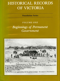
Book, Pauline Jones, Historical records of Victoria : volume 1 : beginnings of permanent government, 1981
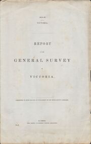
Reproductions of various transactions and reports dealing with the early government of Port Phillip, including laws, surveyors? and administrators? reports, bills, requisitions, prices, police reports, and miscellaneous other documents dealing with the early administration of Port Phillip.victorian history, port phillip, governor bourke, geelong, john batman, treaty, william lonsdale, william buckley, werribee -
 Ringwood and District Historical Society
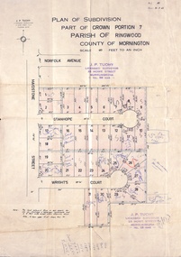
Document, Plan of Subdivision - Part of Crown Portion 7, Parish of Ringwood, County of Mornington - 1962
Map of residential allotments coloured red, with land coloured blue set apart for drainage & sewerage easements. Rubber stamped J.P. Tuohy, Licensed Surveyor, 25 Howe Street Murrumbeena, Tel. 561945, dated 38.8.1962.Map includes Maidstone Street, Norfolk Avenue, Stanhope Court and Wrights Court, Ringwood, Vic. Also includes handwritten Estate Agent sales notations. -
 Greensborough Historical Society
Poster - Planning Document, Shire of Diamond Valley et al, Subdivision Plan # 1044 - Parish of Nillumbik, County Bourke, Crown Allotment B Section 12, Eltham North, 1981-1987
Subdivision Plan # 1044 - Parish of Nillumbik, County Bourke, Crown Allotment B Section 12, Eltham North. This subdivision plan includes Weidlich Road and St Clems Street. The developer for this subdivision is Taunton Developments and the Surveyors are Fisher Cleeland Turner & Dwyer Vic, Surveyors and Engineers.An example of hard copy subdivision plans from the Greensborough area. Mainly from the Shire of Diamond Valley era (1964-1994).Plan (single sided) mounted on heavy card. Stamped and handwritten Council permissions, dates and other details. subdivision plans, shire of diamond valley, taunton developments -
 Bacchus Marsh & District Historical Society
Map, Allotments in the Village of Rowsley, Parish of Gorrocburkghap, County of Grant c.1856
Rowsley is a locality 11 kilometers south-west of Bacchus Marsh. The date of this map is uncertain. A very similar map held by the State Library of Victoria (SLV) contains slightly more information than this copy and is dated as an 1856 map. SLV reference: 'Allotments in the Village of Rowsley, Parish of Gorrocburkghap, County of Grant', by T. Nixon, Assistant Surveyor, May 1856 ; Surveyor General’s Office, July 18 1856 (lithographed by R. Meikle). (1856). Melbourne: Surveyor General’s Office. MAPS 820 BJE 1837- ROWSLEY 1856. A single page paper map. A cadastral map of the Village of Rowsley in Victoria, showing numbered land allotments. 57 allotments are shown on the map and some areas set aside as reserves. Allotments 8, and 10-16 are outlined in red ink and allotment 9 has a cross in red ink on it. The map is pasted into a bound volume containing 76 maps or plans in total. High resolution digital image stored on BMDHS computer network. rowsley victoria history, rowsley victoria maps -
 Phillip Island and District Historical Society Inc.
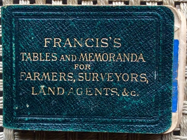
book, Francis’s Tables and Memoranda for Farmers, Surveyors, Land Agents & etc, 1900
Tiny dark green leather book with gold embossed title of measurements and farming advice. 256 pages plus advertisements.Francis’s Tables and Memoranda for Farmers, Surveyors, Land Agents & etc. Signed inside front cover by J. Armstrong and J. Oswinbook, farming, j. oswin -
 Stawell Historical Society Inc
Map, Easton Johnstone, Map of Stawell Surveyed by Easton Johnstone 1872, 1872
Victoria Co Crushing Machine. St Georges Co Crushing machine. Wimmera Co Crushing Machine. Government Reservoir and Drainage. Sloan Street, Skene Street Mines. old Mine WorkingsA2 map of Stawell Reefs Area. Showing Crushing Machines & Title InfoSurveyed by Easton Johnstone Contract Surveyor. Photo-Lithographed at the Department of Lands & Survey. Melbourne By J Noone 9th May 1872mining -
 Bendigo Historical Society Inc.
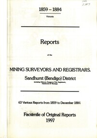
Book - REPORTS OF THE MINING SURVEYORS AND REGISTRARS 1859 - 1884, 1997
Reports of the Mining Surveyors and Registrars, 1859 - 1884. Covering Sandhurst (Bendigo) district, including Kilmore, Kangaroo Flat, Eaglehawk, Heathcote, and Waranga. 63 various reports from 1859 to December 1884. Facsimile of original reports 1997.goldfields, mining reports -
 Bendigo Historical Society Inc.
Document - VICTORIA SURVEY REPORT 1859 TO 60
Four page report presented to both houses of parliament by Surveyor General CH W Ligar dated 1859-60. Object of survey to establish the best method of delineating the boundaries of new allotments in the colony. Geodetic method recommended.bendigo, history, allottment survey -
Clunes Museum
Document - REPORTS
E J Dunn described the geology of the mining in an around Clunes and a recommendation for re-commencing mining operations in Clunes 1909.1 PHOTOCOPY OF A PAGE SHOWING RETURNS MADE BY MINING SURVEYORS AND REGISTERS TAKEN FOR THE QUARTER ENDED 31ST MARCH 1875 .2 & .3 PHOTOCOPY OF TWO PAGES OF A GEOLOGICAL SURVEY COMPLETED FOR THE GOVERNMENT (SENT IN 17/5/1909)NILlocal history, document, mining -
Lakes Entrance Historical Society
Book, Gippsland Heritage Journal No 12 June 1992, 1992
No 12 of Series contains stories of Sealers Cove, Dargo, biographical details of Edward Lees, Surveyor, Lucy Way, photographer, Leah Liddiard and Buchan Charlie, bushranger also information on early Gippsland Newspapers Photographs and maps included.settlers, bibliography, photography, periodicals -
 Orbost & District Historical Society
book, 1922
William Hunter (1893-1971), resident of Tatura and Mallacoota was a soldier, surveyor and amateur naturalist.This item is associated with William Hunter.A black covered book of astronomical observations and results handwritten on lined pages. Inside is a blotter - "Reed Bros Tomato Sauce" ; an envelope addressed to "William Hunter Esquire Survey Camp Tubbut" and three stamps.hunter-william astronomy science -
 Kew Historical Society Inc
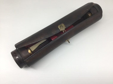
Equipment - Writing Equipment, Writing Case, 19th century, 19th century
Leather pen case, containing writing equipment, possibly used by early surveyor or draftsmanCylindrical leather case containing bottles for ink and sand, holders for pens, nibs, etc. Red leather lining. Ruler, bone-spreader, ivory and brass seal, and pen-holder included. Brass external clasps.writing equipment, writing cases -
 Greensborough Historical Society
Poster - Planning Document, Shire of Diamond Valley et al, Subdivision Plan # 1026 - Parish of Nillumbik, County Bourke, Crown Allotment B Section 12, Eltham North, 1981-1984
Subdivision Plan # 1026 - Parish of Nillumbik, County Bourke, Crown Allotment B Section 12, Eltham North. This subdivision plan includes Ryans Road (also known as Government Road) and St Clems Street. The developer for this subdivision is Taunton Developments and the Surveyors are Fisher Cleeland Turner & Dwyer Vic, Surveyors and Engineers.An example of hard copy subdivision plans from the Greensborough area. Mainly from the Shire of Diamond Valley era (1964-1994).Plan (single sided) mounted on heavy card. Stamped and handwritten Council permissions, dates and other details. subdivision plans, shire of diamond valley, taunton developments -
Tatura Irrigation & Wartime Camps Museum
Book, Adolf Wilke, 15 September 1944 - 1 May 1946
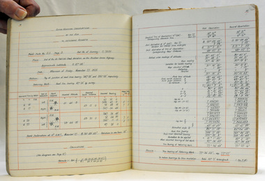
Surveyors book compiled by POW Adolf Wilke who was lecturer in surveying at Camp 13, Murchison.Handmade hard cover, hand stitched book consisting of figures and plans in ink and pencil. 69 numbered pages.adolf wilke, surveying, camp 13 surveying -
Creswick Campus Historical Collection - University of Melbourne
Book, Soil Erosion in Victoria. A symposium arranged by the Victorian Institute of Surveyors, 1940
Series of papers from a symposium arranged by the Victorian Institute of Surveyors. 1940. 2 x copies.DocumentsE.R. Torbett -
Creswick Campus Historical Collection - University of Melbourne
Equipment, 1920s
Surveyors compass in wooden box used up until the 1940s. The box trimmings date to the 1920s.Equipment -
 Federation University Historical Collection
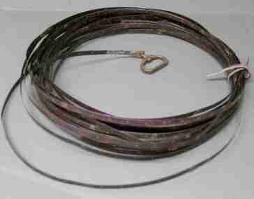
Instrument, Chesterman, Surveyors Tape, c1900
Roll of surveyors metal tape with brass handle stamped '100 ft'. Tape marked in 1 inch, 1 foot and 10 foot intervals. Held in roll with leather tie. End broken off (approx 5 feet missing).Brass handle one end only, stamped 100 ft. Tape stamped 'Chesterman Sheffield England'.surveying tape, scientific instrument -
Whitehorse Historical Society Inc.
Map, Municipality of Nunawading, c1950
Plan No 234, compiled and photo-lithographed at the Melbourne and Metropolitan Board of Works under the direction of G.R. McGowan, Chief Surveyor.Plan No 234, compiled and photo-lithographed at the Melbourne and Metropolitan Board of Works under the direction of G.R. McGowan, Chief Surveyor. Covers the area each Side of Canterbury Road from Orchard Grove to Vernon Street. Includes detail of creeks.Plan No 234, compiled and photo-lithographed at the Melbourne and Metropolitan Board of Works under the direction of G.R. McGowan, Chief Surveyor. blackburn south, gardiners creek, blackburn, blackburn creeklands -
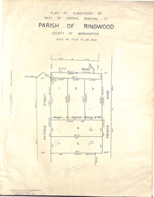 Ringwood and District Historical Society
Document - Folder, Plan of Subdivision - Part of Crown Portion 11, Parish of Ringwood - undated, circa 1950s
Buff coloured survey map of subdivision glued to manilla folder. Five residential blocks bounded by City Road, Victoria Street (later Ireland Street), and Prussia Road (later Regina Street).(Surveyor) R. James Love L.S. M.I.S. (Aust) M.A.I.C. 52 Comer Street Brighton East S6 Phone XB-5928 -
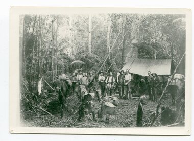 Orbost & District Historical Society
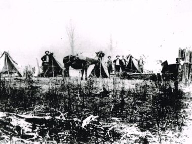
black / white photograph, 1897
Link with item 1178. This is a surveyors' camp in the McCulloch Ranges, Murrangowar, April, 1897. Included in the photograph are: L. Thorn; Pearson; L. Coburn, Clem Bates; Sam Blacklock with a packhorse. They were surveying for a road or railway. Surveyors were among the first European settlers to arrive in Australia. A Surveyor-General was present on the First Fleet, as well as the first two ships which landed in South Australia. These men were issued with instructions to record observations in a journal that included the country’s general appearance, its soil, flora and fauna and the customs and language of local inhabitants. The conditions they worked in were harsh and they embarked on journeys with drays carrying cumbersome surveying and camping equipment, spending months camping out in the bush and mapping the land. It was not until well into the second half of the nineteenth century that the professional training of surveyors became mandatory in Australia.This is a pictorial record of a surveyors' camp in the late 19th century.A black / white photograph of a group of men standing in front of a tent / camp in a dense bush setting.surveyor's-camp-mccullochs-ranges-murrangowar land-settlement -
 Greensborough Historical Society
Article, Anne Paul, Robert Hoddle - Chains and Grids in Terra Nullius, January 2024
Article about Robert Hoddle, his work as a surveyor in early Melbourne and the use of the 'chain' to measure distance.14 page article text and illus.melbourne history, robert hoddle -
 Queenscliffe Maritime Museum
Instrument - Protractor in a flat square wooden box
instrument used by J P Larkin, government marine surveyor in the 20s and 30s in Port Phillip and queenscliffBrass drawing circle - a protractor in a flat square wooden boxsurvey instruments, j p larkin -
 Otway Districts Historical Society
Photograph, Railway survey camp, c.1901, c.1901
Six surveyors and a horse posing outside five tents somewhere on the Beech Forest line in approximately 1901.Photograph, B/W. Railway survey camp, Beech Forest line.survey camp; beech forest; railways; -
 Bendigo Historical Society Inc.
Document - W.D.MASON COLLECTION: MEMORANDUM, 31 May 1900
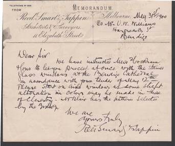
Document, W.D.Mason Collection, Memorandum from Reed, Smart ,Tappin, Architects & Surveyors, 44 Elizabeth Street, Melbourne.dated 31.5.1900 This letter is to inform that you can proceed with the stained glass windows for the Bendigo Cathedral in accordance with your tender of May 12th.business, retail, w d mason -
 Port Melbourne Historical & Preservation Society
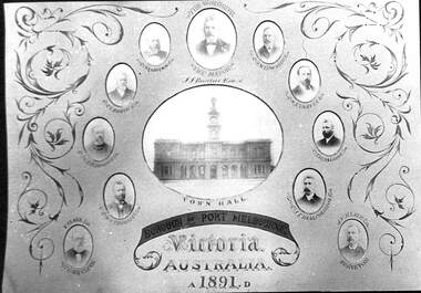
Photograph - Mayor, councillors, town clerk and surveyor, Borough of Port Melbourne
The original piece hangs outside the Council chamber.Poor photographic copy of centre panel from enormous installation piece sent to 1891 Paris international exhibition, showing Town Hall, Mayor, Councillors, Town Clerk and Surveyor, Borough of Port Melbourne. Digital image of Philip SALMON is on databaselocal government - town of port melbourne, port melbourne town hall, james john bartlett, mayors, michael tarver quinn, william henry prohasky, edward clark, arthur victor heath, phillip melville salmon, charles edward smith, james ker beck plummer, john finlay malcolmson, william richardson tarver, henry norval edwards -
University of Melbourne, Burnley Campus Archives
Plan - Photocopy, Edward Owens, Contour Plan of the Town of Richmond, 1873
Photocopy of Contour Plan of the Town of Richmond prepared by M. Egan, Architect and Edward Owens, Cont. Surveyor, 25.03.1873. Plan C. Shows proposed Main Drains and Horticultural Garden. From State Library of Victorian VSL 821.08 Richmond 1873"State Library Vic." in inkdrainage, burnley horticultural gardens, m. egan, edward owens, town of richmond, contour plan -
 Greensborough Historical Society
Poster - Planning Document, Shire of Diamond Valley et al, Subdivision Plan # 1018 - Parish of Nillumbik, County Bourke, Crown Allotment 4 Section 15, and Crown Allotment B Section 12, Eltham North, 1981-1982
Subdivision Plan # 1018 - Parish of Nillumbik, County Bourke, Crown Allotment 4 Section 15, and Crown Allotment B Section 12, Eltham North. This subdivision plan includes Ryans Road (also known as Government Road) and St Clems Street. The developer for this subdivision is Taunton Developments and the Surveyors are Fisher Cleeland Turner & Dwyer Vic, Surveyors and Engineers.An example of hard copy subdivision plans from the Greensborough area. Mainly from the Shire of Diamond Valley era (1964-1994).Plan (single sided) mounted on heavy card. Stamped and handwritten Council permissions, dates and other details. subdivision plans, shire of diamond valley, taunton developments -
 Queenscliffe Maritime Museum
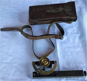
Instrument - Clinometer in leather case
Instrument used by J P Larkin, government marine surveyor active in Port Phillip and Queenscliff in the 20s and 30sA clinometer in its own leather case.T. Cooke and Sons Ltd London and Yorksurveying equipment, j p larkin -
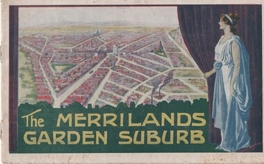 Melbourne Tram Museum
Book, T. M. Burke, "The Merrilands Garden Suburb", late 1919
Book - 12 pages with a fold out double page centre map, centre stapled, titled "The Merrilands Garden Suburb", a real estate marketing brochure for area to the west of the Reservoir rail line, known locally as Merrilands. Marketed on being a gardens suburb to the then Town Planning situation. Contains a suggested loop tram system. Has sales conditions, general information. Marketed by T. M. Burke of 340 Collin St Melbourne. Fold out surveyors map, by Saxil Tuxen, Licensed Surveyor date Oct. 1919. Shows suggested tram routes, reserves, and civic centre.trams, tramways, real estate, reservoir, proposals, new tramway, land -
 Kiewa Valley Historical Society
Photograph Farm Land, Mount Beauty Acreage before Golf Course, Circa 1950
This photograph is a "snap shot" in time circa 1950s detailing the rural environment before the effects of the Kiewa Valley Hydro Scheme altered the basic rural setting of the valley. The golfing fairway was being mapped out on previous grazing land, before the laying of a golf course, for use by the construction workers and auxiliary administration employees of the Victorian State Electricity Commission. This photograph details a dramatic period in time which saw an enormous change to the exclusively rural area of the Kiewa Valley region in the mid 1900s. This change presented both physical and mental challenges to the existing quiet rural inhabitants of the valley. The State of Victoria had to make adjustments to the changing demands imposed by population and industrial expansions. The development of cleaner energy supplies to a growing population has its downside ,which ever way the intrusion into the "natural" landscape is made.Black and white photograph detailing surveyor posts for construction of golf course. Land used, before establishment of the Mount Beauty Village, as farming/grazing cattle and viewed towards Mount Bogong and its Alpine ranges. The photo is on 200gms paper and not on photographic paper.nilmount beauty in the 1940s - 1950s, grazing in the kiewa valley, sec victoria