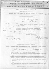
Showing 2777 items
matching 1786-1875. | hume
-
 Wodonga & District Historical Society Inc
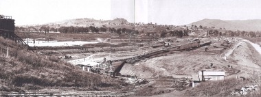
Album - Hume Reservoir Australia Album - General view of earth embankment in Victoria, October 1924
This set of photos is from a leather bound album bearing the inscription "HUME RESERVOIR AUSTRALIA" plus 'The Rt. Hon. L. C. M. S. Amery, P. C., M .P.' all inscribed in gold. It was presented to The Rt. Hon. L. C. M. S. Amery, P. C., M. P, Secretary of State for Dominion Affairs on the occasion of his visit to the Hume Reservoir on 2nd November 1927. This album is of local and national significance as it documents the planning and development of the Hume Reservoir up to 1927. It was the largest water reservoir in the British Empire. The album records the pioneering engineering work that went into its construction.DEPARTMENT OF PUBLIC WORKS, N.S.W. RIVER MURRAY WATERS SCHEME. HUME RESERVOIR. 17. General view of earth embankment in Victoria. New South Wales section of work and Township beyond. October 1924.hume reservoir australia, river murray waters scheme, hume reservoir construction -
 Wodonga & District Historical Society Inc
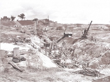
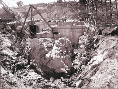
Album - Hume Reservoir Australia Album - Excavation for Foundations of Core Wall September 1922
This set of photos is from a leather bound album bearing the inscription "HUME RESERVOIR AUSTRALIA" plus 'The Rt. Hon. L. C. M. S. Amery, P. C., M .P.' all inscribed in gold. It was presented to The Rt. Hon. L. C. M. S. Amery, P. C., M. P, Secretary of State for Dominion Affairs on the occasion of his visit to the Hume Reservoir on 2nd November 1927. This album is of local and national significance as it documents the planning and development of the Hume Reservoir up to 1927. It was the largest water reservoir in the British Empire. The album records the pioneering engineering work that went into its construction.DEPARTMENT OF PUBLIC WORKS, N.S.W. RIVER MURRAY WATERS SCHEME. HUME RESERVOIR. 9. Excavations for foundations of core wall (in foreground) and part of core wall and earth embankment constructed (in background) in Victoria, September 1922.hume reservoir australia, river murray waters scheme, excavation hume reservoir -
 Wodonga & District Historical Society Inc
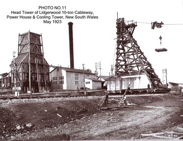
Album - Hume Reservoir Australia Album - Head tower of Lidgerwood, Power House and Cooling Tower May 1923
This set of photos is from a leather bound album bearing the inscription "HUME RESERVOIR AUSTRALIA" plus 'The Rt. Hon. L. C. M. S. Amery, P. C., M .P.' all inscribed in gold. It was presented to The Rt. Hon. L. C. M. S. Amery, P. C., M. P, Secretary of State for Dominion Affairs on the occasion of his visit to the Hume Reservoir on 2nd November 1927. This album is of local and national significance as it documents the planning and development of the Hume Reservoir up to 1927. It was the largest water reservoir in the British Empire. The album records the pioneering engineering work that went into its construction.DEPARTMENT OF PUBLIC WORKS, N.S.W. RIVER MURRAY WATERS SCHEME. HUME RESERVOIR. 11. Head tower of Lidgerwood 10-ton Cableway, Power House and Cooling Tower, New South Wales, May 1923. hume reservoir australia, river murray waters scheme, head tower hume reservoir -
 Dookie Historical Society
Book, Untitled, King James Bible, pre 1875
This Bible was presented to Jane Richards, of Myrniong, by a cousin in 1875.She later married William Martin, father of Eliza Ford of "Hazeldeane" Mt. Major. This bible became the property of Eliza Ford, who was a longtime member of the Dookie district.Brown leather bound embossed King James Bible. First and second book and Gilded pages Part brass clasp missingHand written inscriptions, first in ink, second in biro. First inscription: "Presented to/ Jane Richards by her Cousin W.H.O./ 13th. Nov 7`11 1875" Second inscription: "E.E.Ford/ "Hazeldean"/ Dookie.religion, bible, jane richards, william martin, eliza ford, mt major, dookie, king james, 1875 -
 Eltham District Historical Society Inc
Folder, Charles Kerchevell, 1875
Folder of information on Charles Kerchevelle, Panton Hills, 1875charles kerchevell -
Eltham District Historical Society Inc
Folder, Charles Dale, 1875
Folder of information on Charles Dale, Panton Hill, 1875charles dale -
 Port Melbourne Historical & Preservation Society
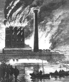
Drawing - Victorian Sugar Works fire, 1875
Photograph of drawing of Victorian Sugar Works fire, 1875built environment, fire and fire services -
 Wodonga & District Historical Society Inc
Album - Hume Reservoir Australia Album - Work inside levee bank, September 1924
This set of photos is from a leather bound album bearing the inscription "HUME RESERVOIR AUSTRALIA" plus 'The Rt. Hon. L. C. M. S. Amery, P. C., M .P.' all inscribed in gold. It was presented to The Rt. Hon. L. C. M. S. Amery, P. C., M. P, Secretary of State for Dominion Affairs on the occasion of his visit to the Hume Reservoir on 2nd November 1927. This album is of local and national significance as it documents the planning and development of the Hume Reservoir up to 1927. It was the largest water reservoir in the British Empire. The album records the pioneering engineering work that went into its construction.DEPARTMENT OF PUBLIC WORKS, N.S.W. RIVER MURRAY WATERS SCHEME. HUME RESERVOIR. 15. Work inside levee bank. Foundations of spillway showing granite foundations and a fault in the formation. New South Wales. September 1924.hume reservoir australia, river murray waters scheme, hume reservoir construction -
 8th/13th Victorian Mounted Rifles Regimental Collection
Photograph
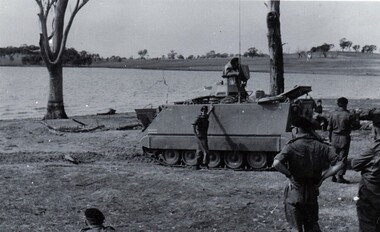
8/13 VMR carried out water training in M 113s at Lake Hume near Albury. The 8th/13th Victorian Mounted Rifles was raised as a regiment of the Royal Australian Armoured Corps on 1 May 1948 with Headquarters in Melbourne and squadrons in Sale, Benalla/Wangaratta and Albury. In 1955 Regimental Headquarters moved to Wangaratta and a second squadron was located at Albury. The Sale squadron transferred to 4th/19th Prince of Wales’s Light Horse. In 1977 8/13 VMR Regiment was reduced to an independent squadron A Squadron 8th/13th Victorian Mounted Rifles and in 1991 was linked with 4th/19th Prince of Wales’s Light Horse forming the VMR Squadron of that regiment.Black and white photograph of M 113 Personnel Carrier preparing to enter water at Lake Hume 1975. -
 Orbost & District Historical Society
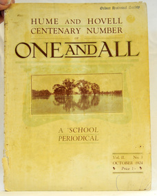
magazine, Clothier & Co, One And All, 1924
This magazine was circulated amongst the pupils, parents, and teachers of the Beechworth Inspectorate, North-East Victoria. This magazine is Vol. 2, no. 3 (Oct. 1924), Hume and Hovell Centenary Number.School magazines were the forerunners of today's school newsletters and were generally published annually. They are contemporary records of the students and staff of the school and usually contain examples of the students' work.This one, published to commemorate the centenary contains information on the Hume and Hovell expedition the purpose of which was to find new grazing land in the south of the colony, and also to find an answer to the mystery of where New South Wales's western rivers flowed. At the centenary of Hume and Hovell exploration in 1924 a committee was formed to co-ordinate and organise local celebrations along the route from Albury to Corio Bay. A roadside cairn was unveiled near Beechworth.A stapled school magazine with a cream coloured cover. It has an illustration of a river and trees reflected in the water on the front. The title, "ONE AND ALL" is at the top in black print. It has " Hume and Hovell Centenary Number" above the title.education-beechworth school-magazine-one-and-all -
 Flagstaff Hill Maritime Museum and Village
Document - Framed Poster, Borough of Warrnambool, Victoria, Australia, after 30/06/1875
This document, also referred to as a word picture or Tablet, is framed in glass and timber with gilt trim, is handwritten with colour highlights. The penned letters rest on ruled guide lines, decorated where the lines intersect. The writing gives a description of the state of Borough of Warrnambool around 1875; its location, the area it covers, its population, Harbour and facilities, public buildings and institutions, imports and exports, financial worth, number of houses, connection with other areas of the Colony. A possible reason and origin for the document is found in an article ‘Link with US Exhibition’ from the Warrnambool Standard of December 19, 1981, written by local historian Bruce Morris. The writer mentions that the Warrnambool Borough Council met on 15th June 1875 and recorded a letter from G.C. Levey , secretary to the Melbourne group of commissioners representing the Colony, and Victoria in particular, for the Philadelphia Centennial Exhibition of 1876. The letter asks Council to provide “statistics as to the population, social condition and commercial and industrial state of the district in and around Warrnambool.” A sub committee was formed for the project. The Mayor, Cr. Thomas King, wrote and signed a Report, presented to the council on July 14, 1875, in which “The Committee … begs to recommend that a Tablet be prepared setting for the particulars respecting the following matters relating to the Borough”. The matters included area, population, annual income, churches, schools, other public buildings, societies and companies, general description of houses erected, and returns of exports and imports for 1874. The minutes note that the Report was adopted. The article above also notes the opinion of Warrnambool printers who have examined the document; it is almost certainly to be an old lithograph, which means there could be several copies. It is possible that there may be a copy in Melbourne and another in Philadelphia. It is interesting to note that (1) the quoted location co-ordinates are for an “Unnamed Road, Packsaddle NSW 2880, Australia”, and that the DMS co-ordinates for Warrnambool’s Council Offices differ, being 38.23.9.12 South, 142.28.52.887. (2) the date for “Exports and Imports for the Year Ending 30th June 1875” is different to the period mentioned by Cr. King in the sub committee’s Report of recommendation “returns of exports and imports for 1874”. The information required to have the figures for the end of June 1875 would need to have been compiled very quickly for the Tablet to be ready for the opening of the Philadelphia Exhibition on 10 May 1876. The document/certificate shows the following – - - - - - - - - - - - - - - -- - - - - - - - - - - - - - -- - - - - - - - - - - - - - -- - - - - - - - - - - - - - - “Victoria Australia, Borough of Warrnambool. Latitude, 30.24.50 South, Longitude 142.32 East The Principal Port in the Western District of the Colony and the Centre of its Choicest Agricultural Lands. Established a Municipality in 1855, and Created a Borough 1863. Population in 1875 4,500. Warrnambool is the nearest Port to Melbourne on the Western Seaboard, being about 160 miles distant. Coaches run to and from the Metropolis daily, in connexion [connection] with the Railway of Geelong and Steamers belonging to Local Companies sail between Melbourne, Warrnambool, Belfast [renamed Port Fairy], and Portland several times weekly. The Harbour is known as Lady Bay, and is partially protected by a reef of rocks stretching from the mouth of the Hopkins River. The formation of a Breakwater has been decided upon by the Government, to extend 600 yards, at an estimated cost of £100,000. There are two substantial Jetties, one of 800 and the other of 600 feet in length. The former is connected with the Town by means of a Tramroad, along which Goods, inwards & outwards, are conveyed, & the latter has been constructed solely for the purpose of facilitating the transit of material for the formation of the Breakwater. In addition to the trade of the Borough and District, the principal Townships up country receive their supplies from Melbourne and ship their exports through Warrnambool. Potatoes form the staple produce of the district, and the richness of the soil can be estimated by the fact that the Government Statistics for 1875 give as the average yield a return of Seven Tons to the acre. Several thousand acres between Warrnambool and Tower Hill are now being laid down in Potatoes by Tenants who have leased the lands at rates up to £5 per acre for the season 1875-6. Wool, Tallow, hides &c are also largely exported, while the shipments of all descriptions of Farm Produce are annually increasing. Area of Borough, 3362 Acres. Net Annual Value £27,000. Annual Revenue £5,500. Number of Houses in Borough 800. Public Buildings and Institutions Churches. Church of England, Roman Catholic, Presbyterian, Wesleyan, Congregational and Baptist. Schools. Three State Schools, average attendance nearly 1000. New Building in course of erection. Several private establishments. Banks. Bank of Australasia, Bank of Victoria, National Bank, Colonial Bank and Savings Bank. Public Buildings. Court house, Custom house, Post & Telegraph Offices, Survey & Land Offices, Shire £, Town Hall, Mechanics Institute, Volunteer Orderly Room, Odd Fellows Hall, Hospital & Benevolent Asylum, Temperance Hall &c. Companies & Societies. Steam Navigation Co, Woolen Mill Co, Gas Co, Racing Club, Amateur Turf Club, Agricultural Society, Farmers’ Club, Cricket Club, Anglers’ Society, Building Society, Freemasons Odd Fellows, Foresters, Druids, Hibernians. Protestant Alliance, Rechabites, Sons of Temperance, &c, Fire Brigade &c. --- Exports and Imports for the Year Ending 30th June 1875 –-- --Exports Total Tonnage 27,800 (Calculated at the Current Warrnambool Market Prices) Potatoes Wool Wheat Barley Hides Skins Fowls Butter Cheese Eggs Tallow Leather Ale Pigs Sheep Sundries --Imports 13,000 Tons Of the Estimated Value of £520,000 Total Tonnage of Exports and Imports 40m900 Tons, Value £806,627 Passenger Travels, to ad from Warrnambool during year, 10,000 persons Revenue from all sources paid through Warrnambool Sub Treasury From 1860 to June 1875 £1, 292, 300 Thomas King [signed] Mayor Henry T Read [signed] Town Clerk” - - - - - - - - - - - - - - -- - - - - - - - - - - - - - -- - - - - - - - - - - - - - -- - - - - - - - - - - - - - - The document is of historical, social, economic and local significance in that it summarises activities, business, community, trade, travel and government at a point in time in Warrnambool’s history – 30th June 1875.Document, also referred to as a ‘word picture’ or ‘tablet’. Document is framed in glass and timber with gilt trim, handwritten with colour highlights. The penned letters rest on ruled guide lines, decorated where the lines intersect. Document outlines the establishment of Warrnambool as a Municipality in 1855 and Borough in 1863, with a population of 4,500 in 1875. It states geographic location, public buildings and institutions, harbor facilities and imports and exports for the year ending 30th June 1875. Two signatures "Thomas King" Mayor and "Henry T Read" Town Clerk. It shows the Coat of Arms of the Borough of Warrnambool.Signatures - "Thomas King" Mayor and "Henry T Read" Town Clerk. Warrnambool Coat of Arms; “British Coat of Arms, above sailing vessel and sheaf of wheat in sun, motto “By these we flourish” and around circumference “Borough of Warrnambool 1855”flagstaff hill, warrnambool, shipwrecked coast, flagstaff hill maritime museum, maritime museum, shipwreck coast, flagstaff hill maritime village, great ocean road, borough of warrnambool, municipality of warrnambool, document borough of warrnambool 1875, word picture of warrnambool 1875, tablet of borough of warrnambool 1875, statistics borough of warrnambool 1875, lithograph borough of warrnambool 1875, coat of arms warrnambool, warrnambool city motto – in these we flourish, establishment of warrnambool, warrnambool history, thomas king mayor of warrnambool, henry t read town clerk of warrnambool, warrnambool breakwater, warrnambool jetty, warrnambool imports and exports 1875, warrnambool agriculture 1875, warrnambool business 1875, warrnambool population 1875, centennial exhibition philadelphia 1876, framed certificate -
 Wodonga & District Historical Society Inc
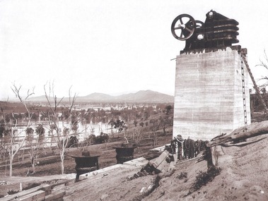
Album - Hume Reservoir Australia Album - Quarry plant being erected September 1921
This set of photos is from a leather bound album bearing the inscription "HUME RESERVOIR AUSTRALIA" plus 'The Rt. Hon. L. C. M. S. Amery, P. C., M .P.' all inscribed in gold. It was presented to The Rt. Hon. L. C. M. S. Amery, P. C., M. P, Secretary of State for Dominion Affairs on the occasion of his visit to the Hume Reservoir on 2nd November 1927. This album is of local and national significance as it documents the planning and development of the Hume Reservoir up to 1927. It was the largest water reservoir in the British Empire. The album records the pioneering engineering work that went into its construction.DEPARTMENT OF PUBLIC WORKS, N.S.W. RIVER MURRAY WATERS SCHEME. HUME RESERVOIR. 7. Quarry plant (New South Wales) being erected, September 1921. Murray Flats (in foreground) and Mitta Mitta Flats (beyond) flooded.hume reservoir australia, river murray waters scheme, quarry plant hume -
 Flagstaff Hill Maritime Museum and Village
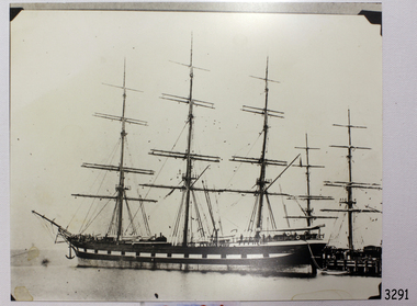
Photograph - Vessel, Sailing Ship, 1875-1905
This photograph is an image of the Loch Vennacher, taken while she is docked. The photograph is very similar to another in our collection taken by Fred. Kruger, a renowned Victorian photographer, between 1875-1905 and possibly in the Port of Melbourne. Loch Vennachar made many journeys from Britain to Australia and was well-known in Australian ports. On one of its homeward-bound journeys from Australia, the ship sank in the River Thames. Its cargo included 850 tonnes of preserved canned rabbits from Warrnambool's Western Meat Preserving Company. The ship was raised and continued trading for another four years. On 14th June 1905, Loch Vennachar departed Glasgow for Adelaide and Melbourne. The last known sighting of it was on 6th September 1875 when overtaken by the SS Yongala; the captains exchanged the “all well” signals. After that, the ship disappeared with loss of all 27 lives, according to a list that was received by Fremantle through the English mail. The list indicated that there were no passengers on that voyage. Sadly, other Loch Line ships med with similar disasters. The list of lost crew on the Loch Vennachar included Thomas. W. Pearce, apprentice, Southampton. His father was Tom Pearce, one of the two survivors of the Loch Ard, wrecked in 1878. Also, Thomas’ grandfather, James Pearce, was the captain of SS Gothenburg at the time of her wrecking in 1875. Consequently, the wrecking of the Loch Vennachar and the Loc Sloy near the southwest point of Kangaroo Island, a lighthouse was erected, officially opening in June 1907. The northern headland of West Bay was named Vennachar Point in memory of the ship in 1908. The wreck was discovered in 1976 by divers from the Society for Underwater Historical Research, over seventy years after being lost off Kangaroo Island.The Loch Vennachar performed a significant role in Australia’s colonial trade, taking goods between Great Britain and Australia. These goods included locally preserved tinned rabbits processed at a factory in Warrnambool for overseas trade.Black and white photograph of Loch Vennachar (aka Loch Vennacher) at a wharf. There are photo mounts in each corner. The vessel was was built in 1875 and wrecked on Kangaroo Island with the loss of all hands; she was last seen September 6th 1905 flagstaff hill, warrnambool, shipwrecked-coast, flagstaff-hill, flagstaff-hill-maritime-museum, maritime-museum, shipwreck-coast, flagstaff-hill-maritime-village, loch vennachar, loch vennacher, loch line ship, glasgow shipping co, 1875 clipper ship, loch vennachar image., kangaroo island shipwreck, 1905 shipwreck, photograph loch vennachar, fred kruger photographer, canned rabbits, preserved rabbits, western meat preserving company -
 Mont De Lancey
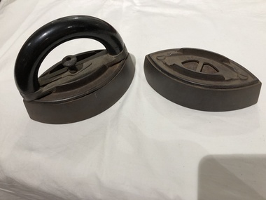
Irons, 1875
Early examples of Mrs. Potts' irons. First patented in 1871. These irons were in sets of three - with one interchangeable handle.2 metal irons with a metal and bakelite interchangeable handle. "Mrs. Potts' iron pat. Oct 18, 1875." "Mrs. Potts' iron pat. Oct 18, 1875/No./Pat. ground." irons, laundry irons -
 Ringwood RSL Sub-Branch
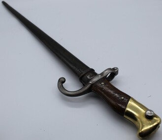
Edged weapon, French Gras bayonet, 1875
French gras sword bayonetMre d'armes de oulle mai 1875 -
 Whitehorse Historical Society Inc.
Report, Boronia Road, 01/06/1875
(a) Application in June 1875 by John Brown, teacher of Vermont School for a lease of land in Boronia Road. (3 pages). (b) Report on the improvements in the land submitted by John Yeoman in November 1875.brown, john, moore, isaac, keenan, yeoman, vermont, land settlement -
Connecting Home
book, Deadly Design, Bewteen Two Worlds, 2008
As a result of the recommendations arising from the Stolen Generations Taskforce Report 2003. The taskforce identified the need for an independant, community controlled organisation in Victoria to be established to meet the needs of the stolen generation in this state. Connecting Home seeks to undertalke activities that will assist members of the stolen generation and engage in publc awareness and education. Historic Significance, this is one of Victoria's first books published that helps to explain the thought & feelings of Stolen Generation people, that has been developed to address recommendations from the Bringing Them Home Report. Social Significance, The information recorded from stolen generation participants explains to non-aboriginal health & human service professionals about the social impact of the politically incorrect times that state & national laws and policies had been introduced to forcibly remove aboriginal & toerres strait islander children form family, land and culture. Research Significance, Soft cover book, with 43 pages. Picture of aboriginal girl, crying, holding teddy bear on front cover. Content is a guide aimed at understanding the Stolen Generations for Health & Human Service Professionals. book, stolen, generations, victoria, victorian, human, resources, syd, jackson, roseann, hepbruns haines, aiatsis, missions, rererves, aboriginal, legal, service, child, care, agency, health, education, consultative, group, housing, cooperative, bringing, them, home, counsellor, program, link, up, koori, heritage, trust -
 Sunbury Family History and Heritage Society Inc.
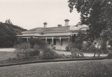
Photograph, 'Glenara' Homestead, 20 August 1952
"Glenara' was the home of Alistair Clark who lived at Bulla which is situated about 20 kms NW of Melbourne in the Deep Creek valley. He was born there in 1864 and lived there throughout his lifetime until his death in 1949. His father established the property during the mid-nineteenth century. Alister Clark was a rose grower and created the very popular 'Lorraine Lea 'rose along with other famous species. A rose garden has been established in the township of Bulla in his memory. He was also an active member of the Victorian Racing Club. The original photograph was published in the Melbourne 'Herald' on 20 August 1952 on page 5.Alistair Clark was a prominent rose grower and developed many rose species which were suitable for Victorian conditions. The homestead is a good example of Victorian architecture built in Victoria in the latter years of the nineteenth century. The house has a heritage listing in the City of Hume Heritage Study.A black and white photograph with a fine white frame, of a Victorian homestead with a a verandah across the front of the house. It is set in a spacious garden with garden beds, lawn and trees.clark, alistair, 'glenara' homestead, roses, bulla, deep creek -
 Warrnambool and District Historical Society Inc.
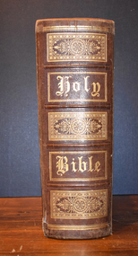
Book - Bible, Thomas Bankes, The Christian's New and Complete Family Bible, 1786
This is a family bible circa late 1700'sThe book has a plain brown leather cover, the front of which is scuffed, stained and completely detached from the spine. On the spine is printed Bankes's Bible, an alternative title. The pages contain text, black and white plates, images and engravings. Some of the pages are torn, others have been repaired with paste. The dedication by Thomas Bankes, a clergyman, is to his Bishop Lord James Beauclerc. All the 's' letters are written as ' f'.non-fictionThis is a family bible circa late 1700's18th century literature, family bible, 1786 bible, warrnambool -
Whitehorse Historical Society Inc.
Book, Grey ribbon to the border, 1973
History of the Hume HighwayHistory of the Hume HighwayHistory of the Hume Highwayhume highway, victoria -
 Wodonga & District Historical Society Inc
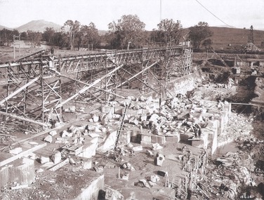
Album - Hume Reservoir Australia Album - Foundation work and dam construction, June 1924
This set of photos is from a leather bound album bearing the inscription "HUME RESERVOIR AUSTRALIA" plus 'The Rt. Hon. L. C. M. S. Amery, P. C., M .P.' all inscribed in gold. It was presented to The Rt. Hon. L. C. M. S. Amery, P. C., M. P, Secretary of State for Dominion Affairs on the occasion of his visit to the Hume Reservoir on 2nd November 1927. This album is of local and national significance as it documents the planning and development of the Hume Reservoir up to 1927. It was the largest water reservoir in the British Empire. The album records the pioneering engineering work that went into its construction.DEPARTMENT OF PUBLIC WORKS, N.S.W. RIVER MURRAY WATERS SCHEME. HUME RESERVOIR. 13. Foundation work and dam construction proceeding inside levee bank which may be seen at the right hand end of the work, New South Wales, June 1924.hume reservoir australia, river murray waters scheme, hume reservoir construction -
 Wodonga & District Historical Society Inc
Album - Hume Reservoir Australia Album - Gravity incline for transport of rocks
This set of photos is from a leather bound album bearing the inscription "HUME RESERVOIR AUSTRALIA" plus 'The Rt. Hon. L. C. M. S. Amery, P. C., M .P.' all inscribed in gold. It was presented to The Rt. Hon. L. C. M. S. Amery, P. C., M. P, Secretary of State for Dominion Affairs on the occasion of his visit to the Hume Reservoir on 2nd November 1927. This album is of local and national significance as it documents the planning and development of the Hume Reservoir up to 1927. It was the largest water reservoir in the British Empire. The album records the pioneering engineering work that went into its construction.DEPARTMENT OF PUBLIC WORKS, N.S.W. RIVER MURRAY WATERS SCHEME. HUME RESERVOIR. 16. Gravity incline for transport of "plums" from Quarry, New South Wales. "Plums" were larger rocks which could be re-used for other construction purposes.hume reservoir australia, river murray waters scheme, hume reservoir construction -
Whitehorse Historical Society Inc.
Document, Alliance House, 1980-1990
Papers relating to the establishment of Alliance House.Papers relating to the establishment of Alliance House, sponsored by Winlaton Community Support Group, funded by the Victorian Ministry of Employment and Training, Buckland Foundation, Felton Bequest and Oliver Hume Fund. Comprises Committee minutes, correspondence and financial records.Papers relating to the establishment of Alliance House.victoria. ministry of employment and training, winlaton community support group, winlaton youth training centre, armstrong, raleigh edward, youth services, alliance house -
 Clunes Museum
Photograph, BEAUCHAMP PHOTOGRAPHY, CIRCA 1881-82
NORTH CLUNES STATE SCHOOL NO. 1552, BRICK BUILDING - BUILT 1875. LATER BECAME HIGHER ELEMENTARY SCHOOL, LATER AGAIN - A CONSOLIDATED SCHOOL.ORIGINAL SEPIA PHOTOGRAPH OF NORTH STATE SCHOOL - BUILT 1875. AND FIVE BLACK AND WHITE PHOTOCOPIES, LATER IT BECAME THE HIGHER ELEMENTARY SCHOOL AND LATER AGAIN A CONSOLIDATED SCHOOL.THE STATE SCHOOL, NORTH CLUNES.local history, 1552, north clunes state school -
 Wodonga & District Historical Society Inc
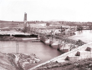
Album - Hume Reservoir Australia Album - General View of Works from New South Wales end, Looking Upstream, August 1927
This set of photos is from a leather bound album bearing the inscription "HUME RESERVOIR AUSTRALIA" plus 'The Rt. Hon. L. C. M. S. Amery, P. C., M .P.' all inscribed in gold. It was presented to The Rt. Hon. L. C. M. S. Amery, P. C., M. P, Secretary of State for Dominion Affairs on the occasion of his visit to the Hume Reservoir on 2nd November 1927. This album is of local and national significance as it documents the planning and development of the Hume Reservoir up to 1927. It was the largest water reservoir in the British Empire. The album records the pioneering engineering work that went into its construction.DEPARTMENT OF PUBLIC WORKS, N.S.W. RIVER MURRAY WATERS SCHEME. HUME RESERVOIR. 23. General view of works from the New South Wales end, looking downstream. The features are generally speaking the same as in the last view 22 (Record WHS 00716) in reverse.hume reservoir australia, river murray waters scheme, hume reservoir construction -
 Vision Australia
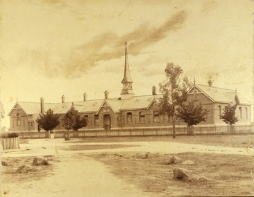
Photograph - Image, Charles Nettleton, Blind Asylum School, St Kilda Road, circa 1875
Unsubstantiated photograph of the Asylum for the Blind in 1875. The four storey bluestone building rises above a group of trees planted in the garden. A picket and wire/string fence border the unpaved circular driveway. 2 black and white images of the Guiding Light at Elanora Blind Asylum School, St Kilda Road Victoria c. 1875 Charles Nettleton 1826-1902 Spencer Scott Sandilands 546 High Street, East Preson, 3181 Melbourne, Victoria, Australia, Tel: (03) 529 8011 Fax: (03) 521 1754 33 George Street, The Rocks, 2000 Sydney, New South Wales, Australia, Tel: (02) 241 4251 Fax: (02) 2414535 Rare Prints, Antiquarian Books, Old Maps, Australiana, Antiques, Photographs, Framing c.1875 Charles Nettleton School from the Blind Original Photograph $65 Guaranteed over 100 years oldroyal victorian institute for the blind, buildings -
 Wodonga & District Historical Society Inc
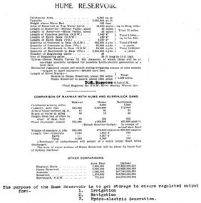
Album - Hume Reservoir Australia Album - Dimensions of Hume Reservoir, Department of Public Works, N.S.W, 1927
This set of photos is from a leather bound album bearing the inscription "HUME RESERVOIR AUSTRALIA" plus 'The Rt. Hon. L. C. M. S. Amery, P. C., M .P.' all inscribed in gold. It was presented to The Rt. Hon. L. C. M. S. Amery, P. C., M. P, Secretary of State for Dominion Affairs on the occasion of his visit to the Hume Reservoir on 2nd November 1927. This album is of local and national significance as it documents the planning and development of the Hume Reservoir up to 1927. It was the largest water reservoir in the British Empire. The album records the pioneering engineering work that went into its construction.Table outlining the Dimensions of the Hume Weir and comparisons with MAKWAR and BURRINJUCK DAMS, and some other comparisons. MAKWAR Dam is located on the Blue Nile about five miles south of Sennar and 175 miles south of Khartoum in Sudan. The construction of this dam started in 1922 and was completed in May 1925, while the British Empire colonised Sudan. It was officially opened on 21st January 1926. The BURRINJUCK DAM is situated in the upper catchment of the Murrumbidgee River, approximately 60 kms from Yass, N.S.W. It was built from 1907 to 1927 The stated purpose of the Hume Reservoir is to get storage to ensure regulated output for:- 1. Irrigation 2. Navigation 3. Hydro-electric Generation.hume reservoir australia, river murray waters scheme, hume dimensions -
 Wodonga & District Historical Society Inc
Album - Hume Reservoir Australia Album - Valley of the Murray to be crossed by the Bethanga Bridge 1927
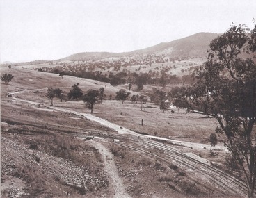
This set of photos is from a leather bound album bearing the inscription "HUME RESERVOIR AUSTRALIA" plus 'The Rt. Hon. L. C. M. S. Amery, P. C., M .P.' all inscribed in gold. It was presented to The Rt. Hon. L. C. M. S. Amery, P. C., M. P, Secretary of State for Dominion Affairs on the occasion of his visit to the Hume Reservoir on 2nd November 1927. This album is of local and national significance as it documents the planning and development of the Hume Reservoir up to 1927. It was the largest water reservoir in the British Empire. The album records the pioneering engineering work that went into its construction.DEPARTMENT OF PUBLIC WORKS, N.S.W. RIVER MURRAY WATERS SCHEME. HUME RESERVOIR. 36. Valley of the Murray to be crossed by the Bethanga Bridge described in the next photograph. (WHS 00731) This view shows the marshalling sidings for trucks below the Quarry, New South Wales, and the branch line to the site of the bridge.hume reservoir australia, river murray waters scheme, hume reservoir construction -
Clunes Museum
Book, DRAWINGS & DESCRIPTION OF CLUNES WATER WORKS VICTORIA, 1875
LARGE BOOK DATED 1875. DRAWINGS AND DESCRIPTIONS OF CLUNES WATERWORKS. CONTAINS 12 PAGESlocal history, clunes, water works, drawings -
 The Beechworth Burke Museum
Photograph, American and Australasian Photographic Company, 1875
Taken in Beechworth 1875, this photograph depicts the Camp Street intersection looking east. This photograph was taken and produced by the American and Australasian Photographic Company which was founded by Beaufoy Merlin joined by his assistant, Charles Bayliss and Augustus Clinton, and operated between 1866-1873. The company traveled throughout Victoria and New South Wales before establishing a portrait studio in Sydney. There is no apparent connection to America. Black and white rectangular postcard. The image is printed on matte photographic paper and is mounted on cardboard. Obverse: NO INSCRIPTION Reverse: 1997.2726 A02726 BEECHWORTH ABOUT 1875 Harvey Collection American & Australasian Photographic company. Victoria Branch. C. BAYLISS, Manager. NO.59 Extra copies may be had by sending Number to present Address.beechworth, burke museum, camp street, 1875, charles bayliss