Showing 15878 items
matching areas
-
 Sunbury Family History and Heritage Society Inc.
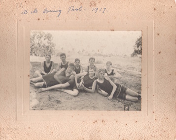
Photograph, Sunbury Swimming Club
The photograph was taken of swimmers at the water hole at The Nook in Sunbury in 1917. The pool at The Nook was the town's only swimming area from 1916 to 1966, when an Olympic size swimming pool was built in Ligar Street.A non-digital sepia photograph mounted on cream board of eight young men sitting on a grassy area and dressed in swimwear c1917.sunbury swimming club, the nook, swimming, sports -
 Whitehorse Historical Society Inc.
Article, Friends of the lake education unit, 1/03/1996 12:00:00 AM
Article from Whitehorse Gazette on Dorothy Meagher.Article from Whitehorse Gazette on Dorothy Meagher who started the Friends of the Lake Education Unit in 1985 to give knowledge to children on how to care for the bushland area.Article from Whitehorse Gazette on Dorothy Meagher. meagher, dorothy, blackburn lake sanctuary -
 Hume City Civic Collection
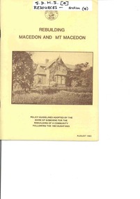
Booklet - Policy guidelines adopted by Shire of Gisborne, Rebuilding Macedon and Mt. Macedon, August 1983
A booklet outlining the policy guidelines adopted by Shire of Gisborne Council to rebuild the community after the 1983 bushfires.A 27 page booklet outlining policies adopted by the Shire of Gisbourne for rebuilding the local community after the 1983 bush fires. The cream pages have sepia photographs throughout the booklet of a variety of buildings and sites throughout the area that were affected by the fires.non-fictionA booklet outlining the policy guidelines adopted by Shire of Gisborne Council to rebuild the community after the 1983 bushfires.mt. macedon, macedon ranges, ash wednesday fires, bush fires -
 City of Kingston
Photograph - Black and white, 20 December 1945
Cheltenham is a suburb in the City of Kingston that was originally established as a rural market gardening community. The area is bordered by Highett, Mentone and Heatherton. The market gardens, farms and paddocks have gradually been sub-divided into housing and industrial estates. The Southland shopping centre is a major feature of the area.Cheltenham was established as a rural market gardening community. The Le Page family lived in Cheltenham since 1854 when Nicholas Le Page, a tailor from the Channel Island of Guernsey, bought two acres of land on Chesterville Road near Bernard Street to establish a market garden. Over the years the Le Pages purchased more land in the area. In 1875-76 Nicholas' son Frank and his wife Mary built 'Daphne Cottage' near the corner of Bernard and Wilson Streets. n the 1940s Frank's son, Everest Le Page, bought five more lots of land in Chesterville Road from the Tuck family. The Le Pages grazed horses, ponies and cows on this land, and grew pumpkins, carrots, parsnips, onions, potatoes and cabbages. Many buildings and locations within in Cheltenham commemorate the Le Page family's contribution to the Cheltenham community.Aerial photograph taken in 1945 of the Cheltenham district within the City of Kingston. The image includes Chesterville Road, the future site of Turner Road pool (now Waves) and Highett Reserve, (top left), Jellicoe Street, Argus Street, Bernard Street, Wilson Street, the Methodist Children Homes (now Southland), McIvor Street, Goulburn Street, Nepean Highway, Jamieson Street and Barker Street (bottom left), market gardens and paddocks. In the top centre of the image, "Daphne Cottage", the home of Frank T. Le Page is visible on the corner of Bernard and Wilson Streets. Much of the land depicted in this image was owned by the Le Page family. This image is possibly from the collection of aerial photographs commissioned by the Department of Crown Lands and Survey and taken by Adastra Airways.Black and white ink: 57250 White print: VIC-170 57250 20.12.45 Run 6 PROJ. No. 5 MELB. METROP AREA Black type 10200 FTS 30' LENS 20.12.45cheltenham, market gardens, industry, le page family -
 Tatura Irrigation & Wartime Camps Museum
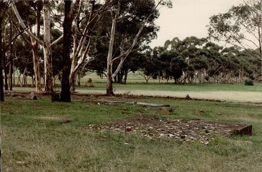
Photograph, Camp 1 Sports Ground, 1989
The open grassed area is the remains of the football ground constructed at Camp 1. Foam backed copy in file.Coloured photograph. In foreground there is a large, flat, low, rectangle of concrete rubble. To the left of this concrete is a smaller rectangle of concrete. In centre of photograph is an open grassed area flanked by trees.camp 1, tatura victoria, internment camps, internment camp football fields, internment camp remains -
 Ballan Shire Historical Society
Map - Map. Korweinguboora, Department of Lands and Survey, Korweinguboora. Counties of Talbot and Grant
A map of the Korweinguboora area showing roads, forests, railway lines and properties with the owners names.The inclusion of the names of landowners is of significance and value to historians.A map of the Korweinguboora area showing land subdivisions and names of owners and other physical features. There is a scale in chains. No date is certain but it could be 1902. The map has been repaired with sellotape.There are various pencil annotations but the are difficult to read.talbot, moorarbool west, wombat, bullarto, korweinguboora, moorarbool east, dean, wombat state forest, barkstead -
 8th/13th Victorian Mounted Rifles Regimental Collection
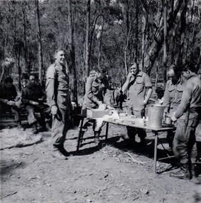
Photograph
Echelon area was a grouping of administrative and support elements of a squadron located behind forward elements. Usually contained fuel, water and ration vehicles, LAD and medical aid vehicle.Black and white photograph of 8/13Victorian Mounted Rifles soldiers at a hasty lunch point in an echelon area during Annual Camp, Puckapunyal, 1971." Cpl Frohling, Cfm Maddocks, Lt Shefford, Cfm Martin " Soldier at right not known. -
 Sunbury Family History and Heritage Society Inc.
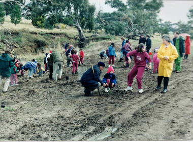
Photograph, Tree planting
The students from Bulla Primary School were taken on a school excursion to nearby Woodlands Park where they took part in a tree planting activity. They were planting trees that were native to the area in a bid to replenish the parkland with natural vegetation.The excursion aimed to give the students an awareness of the native vegetation in the area and the importance of conserving natural growth areas. A non-digital photograph of a group of children planting young trees in a prepared area in parkland while being supervised by a number of adults tree planting, woodlands park, bulla primary school, native vegetation -
Whitehorse Historical Society Inc.
Document, History notes supplied by Bert Mock, n.d
History of the Mock Family.History of the Mock Family who came to East Burwood in 1885 and took over one of the Fankhauser properties to plant orchards. Also gives details of life in the area.History of the Mock Family. mock family, pioneers, orchards, burwood east -
 Ballarat Tramway Museum
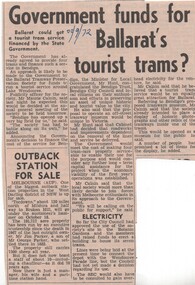
Newspaper, The Courier Ballarat, Government funds for Ballarat's tourist trams?", 22/09/1972 12:00:00 AM
Newspaper clipping from The Courier, 22/9/1972 about the BTPS seeking government funding for the museum and its development. Quotes Publicity Officer, Mr Maurie Calnin. Also gives notes on progress so far, mentions Bendigo and power supply.Date "22/9/72" in headline area.trams, tramways, museum construction, funding, btps -
 Ballarat Tramway Museum
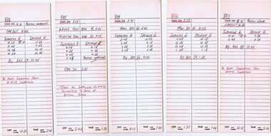
Document - Table Cards, Ballarat Tramway Preservation Society(BTPS) and P. Winspur(BTPS) and G. Young, 1979 Australia Day cavalcade, Jan. 1979
Yields information about the arrangements for the Australia Day Cavalcades and the way crews were arranged.Eleven heavy cards printed as M&MTB table cards for drivers, but used by the BTPS as run tables for 1979 Australia Day cavalcade for both drivers and conductors - separate cards for each. Prepared in black and green ink with notes. Each card has its own table number. Item Card No. For 325.1 801 Driver ex Preston 325.2 802 Driver 325.3 804 Driver 325.4 805 Driver to Preston 325.5 806 Conductor ex Preston 325.6 807 Conductor 325.7 808 Conductor 325.8 809 Assistant Conductor 325.9 810 Assistant Conductor 325.10 811 Assistant Conductor 325.11 812 Conductor to Preston No. 803 was retained by Bob Prentice on the day. Image of items added 2/11/13.325.7 has pen marks in top area.trams, tramways, mmtb, btps, melbourne, australia day -
Whitehorse Historical Society Inc.
Pamphlet, Blackburn bellbird area, 1986
Pamphlet on proposal to extend planning controls over buildings, subdivision and tree removal introduced in 1985.Pamphlet on proposal to extend planning controls over buildings, subdivision and tree removal introduced in 1985. Now these controls are proposed to extend over a further 53 streets in Blackburn's 'Bellbird Area'.Pamphlet on proposal to extend planning controls over buildings, subdivision and tree removal introduced in 1985. town planning, victoria. department of planning and environment, blackburn -
 Warrnambool RSL Sub Branch
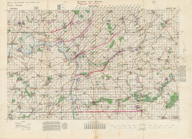
MAP TO ACCOMPANY HEAVY ARTILLERY SCHEME FOR MOBILE WARFARE".....marked with 'Lanes' and Corps/Division Boundaries, Ordnance Survey, 1:40,000, France. Sheet 62c, Dec 1917. (centring on Peronne and Mont St Quentin), December 1917
Shows detail of Artillery Planning in the area of Peronne & Mont St Quentin. Inscribed "Map to accompany H.A. Scheme for Mobile Warfare". Marked with 'Lanes' and Corps/Division Boundaries.The donor, Staff Sergeant R.O. (Bob) Snape, Reg No 8651, enlisted as a Stretcher Bearer in 1915 but, because of his secretarial skills was employed in HQ positions as soon as he arrived in France and as a stenographer who worked as Confidential Clerk to General Sir John Monash from June to December 1918; and subsequently, for General Sir Talbot Hobbs until June 1919. The map was very likely directly used in the planning of the 1918 battles such as Mont St Quentin.Original Item recovered from possibly Australian Corps HQ, probably between the Armistice, 11 November 1918, and June 1919, when Staff Sergeant R.O.(Bob) Snape was repatriated. Shows detail of Artillery Planning in the area of Peronne & Mont St Quentin. Inscribed "Map to accompany H.A. Scheme for Mobile Warfare". Marked with 'Lanes' and Corps/Division Boundaries.snape collection -
 Diamond Valley Vietnam Veterans Sub-Branch
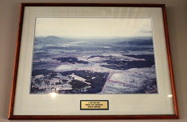
Photograph - Nui Dat, c2002
Very early photo, framed, 1 Australian Task Force Area, Nui Dat, Phuoc Tuy Province, South Vietnam. Circa 1966Photo of earliest days of 1ATF.Photo, Framed, wooden; arial photo of 1 Australian Task Force Area (1ATF), Nui Dat, Phuoc Tuy Province, South Vietnam. Circa 19661ATF, Nui Dat, Phuoc Tuy Province, South Vietnam.vietnam, vietnam war, diamond valley vietnam veterans sub branch -
 Halls Gap & Grampians Historical Society
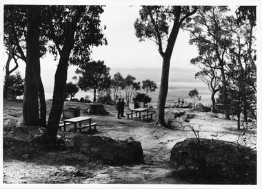
Photograph, C 1960s (?)
People at the Boroka Lookout picnic area.Photo shows two men standing close to a picnic table in a picnic area near a lookout (Boroka Lookout). Two other people are standing at the wire fence of the lookout. A valley and distant ranges can be seen in the background.scenery, lookouts -
 Otway Districts Historical Society
Book, Adventures with shipwrecks
An account shipwrecks from 1880 to 1958 in the Apollo Bay area.Adventures with shipwrecks. An account of wrecks in the Apollo Bay area. J.K. Loney. 1st ed. Apollo Bay (Vic); J.K. Loney; nd. 20 p.; illus, map. Soft cover.222mm x apollo bay; j.k. loney; shipwrecks;, apollo bay; j.k. loney; shipwrecks; -
 Lakes Entrance Historical Society
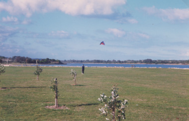
Photograph, Lakes Post Newspaper, 1/04/1999 12:00:00 AM
Recreation area east of the footbridge. The artificially constructed knoll beside lake in the distance one person flying a kite from lawn Lakes Entrance Victoria. Also three colour photographs showing progress of recreation area east of the footbridge and instillation of rotunda. Small boy in foreground is Jarrod Elstob of Paynsville 04270.1, 04270.2, 04270.3 size 10 x 15 cmColour photograph taken of the newly planted trees on the recreation area east of the footbridge. The artificially constructed knoll beside lake in the distance one person flying a kite from lawn Lakes Entrance Victoria. Also three colour photographs showing progress of recreation area east of the footbridge and instillation of rotunda. Small boy in foreground is Jarrod Elstob of Paynsville 04270.1, 04270.2, 04270.3 size 10 x 15 cmtownship, waterfront -
 Bendigo Military Museum
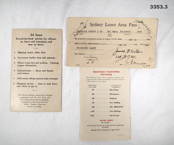
Administrative record - LEAVE PASS & INFORMATION CARDS, c.1942
American Forces issue..1) Cream coloured Information card, black print on front. Map & information on reverse side in black & red print. .2) Cream coloured Sydney Leave Area Pass, black print. .3) Cream coloured Information sheet, paper, black & red print on both sides..2) Typed: “Sydney Leave Area Pass Thompson, Robert J Jnr, CPL Tech 33099209 Army from Dec 10 1943 to Dec 25 1943, APO 928 BRISBANE 2nd JN”administration, leave, pass -
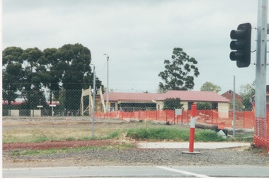 Sunbury Family History and Heritage Society Inc.
Photograph, c1999
The open are in the foreground was part of railway land on the west side of Sunbury Station along Horne Street. The initial preparations to develop the area into a commercial and entertainment precinct were just commencing. The development that took place on this site was indicative of the growth that was taking place in Sunbury in the early 2000sA coloured photograph of an open area feed off with temporary netting in preparation for construction work. A set of traffic lights are on the RHS of the photograph and a station is in the middle distance.sunbury railway station -
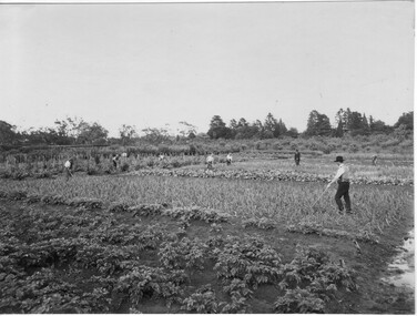 University of Melbourne, Burnley Campus Archives
Photograph - Black and white print, Students Working in Cropping Area, 1917-1921
Used as an illustration in, "Green Grows Our Garden," A.P. Winzenried, p 36, with the caption, "Cropping area, looking west; the ornamental gardens are to the right, and Heyington railway bridge to the left. The figure with the walking stick is probably J.P. McLennan." Note by T.H. Kneen 10 June 1992, "On later inspection both EBL and THK now doubt that the person "supervising" is McLennan - but the date of the photograph is a reasonable estimate."Black and white photograph. Students working in cropping area in the Orchard with a Staff member supervising. 2 copies.green grows our garden, a.p. winzenried, cropping area, west orchard, students working outside, staff -
Whitehorse Historical Society Inc.
Map, Dandenong Ranges Area, 1955
Sheet 13. Parts of Parishes: Nunawading, Mulgrave and Scoresby.Sheet 13. Parts of Parishes: Nunawading, Mulgrave and Scoresby. Includes area of Vermont South marked as proposed Township of Norwich. Scale 10 chains : 1 inch. Contours marked.Sheet 13. Parts of Parishes: Nunawading, Mulgrave and Scoresby. maps, vermont south, wantirna, dandenong creek -
 Warrnambool and District Historical Society Inc.
Map, Plans (5) showing Subdivisions of Warrnambool, 1989
These plans have been drawn by Steve Hester for the Warrnambool City Council to illustrate the allotments in Warrnambool concerned with the subdivisions of 1989. The streets have not been named but there is an indication of the area with the identification of known buildings (eg Hospital) and the plan numbers of each allotment is clearly marked. These numbers corresponded to the plan numbers registered in card files and ledgers in the Warrnambool City Council offices. The scale of the plans was 1 to 5000. These plans are of considerable interest because they show Warrnambool street subdivisions of 1989 in illustrative form. They show how information was collated in the late 1980s before the widespread use of computer digital means to describe and store information.These are five hand-drawn sheets showing plans of sub-divisions in Warrnambool streets in 1989 (Warrnambool City Council material). The plans are multi-coloured (crayons) and show allotments with plan numbers. The first plan has much of the material torn off but the location is known to be in the Russells Creek area. Some of the green tape around the edges is missing. Plans two to five are almost intact and are bound with green tape. Plan Two- Industrial Estate of West Warrnambool; Plan Three – Hospital/Merrivale/ Lake Pertobe areas; Plan Four – North Warrnambool, Wollaston/Brierly areas; Plan Five – Flaxman Street area. ‘Subdivision Plan, Reference Guide, Steve Hester, Oct. 1989’. warrnambool street subdivisions, steve hester, history -
Whitehorse Historical Society Inc.
Pamphlet, Blackburn South Recreation Trail, 1989
Pamphlet outlining the history of the linear park along the alignment of the discontinued Healesville freeway.Pamphlet outlining the history of the linear park along the alignment of the discontinued Healesville freeway. It includes plans for the immediate future, the development of Fulton Reserve and lists the Committee of Management. A plan of the area is on the verso.Pamphlet outlining the history of the linear park along the alignment of the discontinued Healesville freeway.wurundjeri walk, fulton reserve, blackburn south recreation trail, city of nunawading -
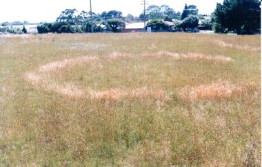 Hume City Civic Collection
Photograph, early 1990's
This is one of a series of Aboriginal rings which are found in the Sunbury area. The former Shire of Bulla published a detailed study of the Aboriginal Ring sites in the early 1990's.A coloured photograph of a sacred site featuring an Aboriginal ring within the Sherwood Housing Estate. There is a cleared grassed area with a distinctive ring in the foreground with the housing estate in the background.sherwood estate, aboriginal ring sites, george evans collection -
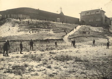 Federation University Historical Collection
Photograph, Ballarat Junior Technical School - outside the Ballarat Gaol Wall, c1921
In February 1913 the Ballarat Junior Technical School opened its doors to its 86 pupils. The old bluestone building in the grounds of the Dana Street Primary School became their temporary home for eight years. In its early years the school offered only a two-year course. The first year was of a general nature giving a thorough grounding in Mathematics and Instrumental Drawing, and introducing students to the various branches of trade work. The second-year students studied for the Junior Technical Certificate and specialized in a course of their choice - either a trade (Woodwork or Fitting and Turning) or a course leading to higher studies at the School of Mines. Increased enrolment - 86 to 110 in the second year. Some applicants were turned away due to lack of space. An abandoned single room school was brought in and this helped for a time. Plans were developed and a two-storied red brick building in the vacinity of the School of Mines was build. An acre of land was reclaimed from the north-east corner of the Ballarat Gaol. The school backed onto the wall of the gaol. The task of landscaping and terracing of the area was to cost a great deal and time. The boys did much of the heavy work. This kept them occupied as the official playground areas were still full of rubble.View from the south-east of the Junior Technical School with the slope from the gaol wall down to the area known as the Battery Paddock. The new school building was a two-storied red brick building along the Education Department style of the 1920s. On 9 September 1921, the Junior Technical School building was officially opened. Much work was needed to terrace and landscape the area. Students shown in various areas of the grounds.junior technical school, dana street primary school, bluestone, mathematics, instrumental drawing, junior technical certificate, woodwork, fitting and turning, school of mines, ballarat gaol, landscaping, terracing, gaol wall, cricket -
 Halls Gap & Grampians Historical Society
Photograph - B/W, C 1940s
This is a photo of the Zumsteins camping area, which was popular with families.The photo shows a group of six people, two standing near, and four seated at, a picnic table. There is a large canvas tent/structure with boxes and tins at the entrance to the left and behind it there is a corrugated iron building. The area is surrounded by bush.recreation, camping, scenery, zumsteins -
 Flagstaff Hill Maritime Museum and Village
Textile - Tapestry, 1988
A thousand years of Warrnambool history has been documented in this creative tapestry, woven in 1988. The Tapestry hangs in the Great Circle Gallery at Flagstaff Hill and complements the theme of the display. Three local women with the help of Museum staff researched and designed the tapestry, which was woven in 1988 from wool and cotton. It is 10 meters long and 70 cm deep and took 7 months to create. The tapestry introduces the seafaring theme of the Center and illustrates a timeline of events dating back to the arrival of Europeans in the Warrnambool area. It begins with the settlement of the area by Europeans and travels back in time as you walk further into the gallery, depicting shipwrecks along the coast, whaling of the area, early exploration by Europeans James Grant and Nicholas Baudin, back to the indigenous settlement of the area, represented by middens and indigenous symbols. (Interestingly prior to being hung in the gallery, the tapestry was originally hung with the intention of being framed from right to left). All materials in the cotton and wool tapestry, includinghand-dyed dyed wool, were prepared for a cost of $33,000. (This information is from Flagstaff Hill Maritime Village's Exhibit fact sheet)Tapestry of the early history of Warrnambool area, rectangular in shape. Materials include cotton and wool, some of the wool being hand dyed. Made in 1988 by local women.A plaque accompanies the Tapestry "Flagstaff Hill Maritime Tapestry / 1989 / Tapestry: Woven Cotton and Wool / Mary O'Brien Gerda Shanley / Judith Stewart Beryl Conlan"flagstaff hill, warrnambool, shipwrecked-coast, flagstaff-hill, flagstaff-hill-maritime-museum, maritime-museum, shipwreck-coast, flagstaff-hill-maritime-village, tapestry, warrnambool history, warrnambool textiles, south west victoria history, south west victoria timeline, indigenous people -
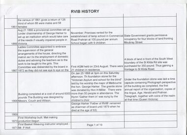 Vision Australia
Document - Text, RVIB History
19 pages in table format, of events that occurred and people who were involved with the RVIB, and 1 page showing an aerial view of an unknown area. Possibly used as a base for creating in house history or to assist the foundation of Lighthouse on the Boulevard.19 pages in table format, of events that occurred and people who were involved with the RVIB, and 1 page showing an aerial view of an unknown areanon-fictionelizabeth maxwell, neil maxwell, royal victorian institute for the blind -
Whitehorse Historical Society Inc.
Pamphlet, George Cox cares for Mitcham
George Cox, state member for Mitcham and foundation member and past president of Blackburn and District Tree Preservation SocietyGeorge Cox, state member for Mitcham and foundation member and past president of Blackburn and District Tree Preservation Society has put out a pamphlet recommending a selection of Australian plants known to thrive in this area.George Cox, state member for Mitcham and foundation member and past president of Blackburn and District Tree Preservation Societynative plants, cox, george, blackburn and district tree preservation society -
Whitehorse Historical Society Inc.
Document, Street names, 1989
Artic;le by Gwenda Trethewy, member of Nunawading Historical SocietyArtic;le by Gwenda Trethewy, member of Nunawading Historical Society, on the history of the Mitcham street names, Endeavour, Flinders, Moresby and Beaufort, Oct - Dec 1989 and map of the area and an extract of the article.Artic;le by Gwenda Trethewy, member of Nunawading Historical Societystreet names, trethewey, gwenda, turner, (commander), nunawading historical society, endeavour street, mitcham, flinders street, mitcham, moresby street, mitcham, beaufort street, mitcham