Showing 795 items
matching assessments
-
 Bendigo Historical Society Inc.
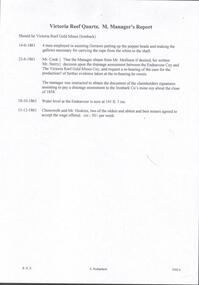
Document - VICTORIA QUARTZ - VICTORIA REEF QUARTZ MINE MANAGER'S REPORT
Two copies of the Victoria Reef Quartz Mine Managers report. The report mentions putting up the poppet heads, drainage assessment, water level and two men offered 50/- per week. Dates 14/6/1861, 22/6/1861, 18/10/1861 and 13/12/1861.document, gold, victoria quartz, victoria quartz, victoria reef quartz mine manager's report, victoria reef gold mines, gerraws, mr cook, mr sterry, mr mollison, endeavour coy, the victoria reef gold mines coy, ironbark co, endeavour, chenoweth, mr hoskins -
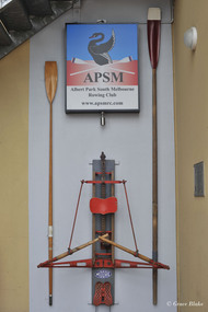 Albert Park-South Melbourne Rowing Club
Moore Sculling Machine
"Grace Blake’s conversations with older members of the Club have elicited the following information during July 2014: • Don Christie recalls the machine being acquired by (or donated to) SMRC in the 1960s. SMRC later donated it to APRC. • Bob Duncan remembers it being at APRC. • Max Shaw joined the club in 1946 but doesn’t recall it at all. • Peter Watson recalls collecting the rowing machine from the old APRC club house before its demolition (c. 1995). The AP-SMRC machine carries a ‘maker’s plate’ with the name Moore... Moore Crane and Engineering Company Pty Ltd was a subsidiary of Malcolm Moore Industries Ltd whose manufacturing engineering works were located on Williamstown Road, Port Melbourne from 1927. The founder established the main business in 1921 and retired in 1953.21 The business was delisted from the Australian Stock Exchange in 1976. Grace Blake advises that some of the earlier SMRC members were plumbers and therefore worked in trades connected with engineering. She reports that Peter Watson recalls some of his contemporaries completing their engineering apprenticeships at Malcolm Moore Industries Ltd in the 1970s. There are still many unanswered questions concerning the history and provenance of the rowing machine at the time of writing this report, but the connection with a local engineering works is certainly fascinating. Questions to explore in the future include: Did Moore manufacture the machine, or import it (and perhaps assemble it) under licence? Was this machine a ‘one-off’ or did Moore make / distribute others within Australia? When, why and how did SMRC acquire the machine? Why did SMRC decide not to retain it, but to pass it over to APRC? And how did APRC use it?" 2014 Significance Assessment, pp38-40. "The ‘Moore’ Rowing Machine at the Albert Park – South Melbourne Rowing Club (AP- SMRC) is a rare example in Australia of the Kerns patent design from 1900. This machine may not, however, be that old in construction or use. The AP-SMRC machine is almost intact, appearing to lack only the leather straps for fastening the rower’s feet to the foot-rests. Spalding manufactured the design in the USA in the early decades of the 20th century, but the metal elements in its models are traditionally black. The bright red paint on the AP-SMRC machine suggests something different. The AP-SMRC machine carries a maker’s plate that associates it directly with a local engineering business, Malcolm Moore Industries Ltd of Williamstown Road, Port Melbourne. Club members recall the machine being at the South Melbourne Rowing Club in the 1960s, and being transferred at a later date to the Albert Park Rowing Club. The machine has not been used since the founding of the amalgamated AP-SMRC and requires careful conservation. The ‘Moore’ rowing machine is of national research significance as a rare survivor, in Australia, of the well-regarded Kerns patent design that was popularised by Spalding in the northern hemisphere. The English River and Rowing Museum website quotes a testimonial from an AG Spalding & Bros’ Mail Order Catalogue: ‘This machine was described by ‘an experienced oarsman’ ... “to be the most perfect rowing machine ever produced”. A feature was the adjustment of the resistance so “the weaker sex can use the machine”’. Its historic significance lies in its rarity (and perhaps uniqueness) as an aid to the training of rowers at two successful clubs on Albert Park Lake. Additional historic significance lies in the connection that the rowing machine represents between local rowing clubs and a major local manufacturing engineer. The ‘Moore’ rowing machine bridges the realms of innovation and application, of industry and recreation, of land-based and aquatic sports, and of two neighbouring rowing clubs on the Albert Park Lake." 2014 Significance Assessment, p43"A rowing machine that appears to be built to the Kerns patent design from 1900 but may not be that old in construction or use. The machine is heavy and includes parts made from cast iron. The cast iron components are painted in a distinctive bright red. The wooden seat moves on timber slides. Resistance is created by spring mechanisms at the ends of two frame elements that connect with two wooden ‘oars’, and by the central chain-driven system that co-ordinates with the rower’s movements. The machine carries a maker’s plate with the single word ‘Moore’ in an oval design, using white letters against a navy background, fastened to the base board and close to the foot-rests." 2014 Significance Assessment, p38Moorerowing, apsm rowing club, significance assessment, malcolm moore industries ltd, kerns, 1900, sculling machine, albert park rowing club, south melbourne rowing club, albert park lake, rowing machine, ergo -
 Whitehorse Historical Society Inc.
Book, Nubrik heritage value assessment, 1/10/1999 12:00:00 AM
Heritage value assessment of the proposed H 062 former Brick Industries Ltd / Brick and Pipe Industries Ltd (Nubrik) Brickworks, 78 Middleborough Road, Burwood East.Heritage value assessment of the proposed H 062 former Brick Industries Ltd / Brick and Pipe Industries Ltd (Nubrik) Brickworks, 78 Middleborough Road, Burwood East. Prep. for the owners, Reading Entertainment Australia Pty Ltd [by] D.V. Bick. With report to the Nunawading & District Historical Society on the property, by Anne Jones.Heritage value assessment of the proposed H 062 former Brick Industries Ltd / Brick and Pipe Industries Ltd (Nubrik) Brickworks, 78 Middleborough Road, Burwood East. brick industries limited, middleborough road, burwood east, no. 78, brickworks, quarries, reading entertainment australia pty ltd., nunawading and district historical society inc. -
 Kew Historical Society Inc
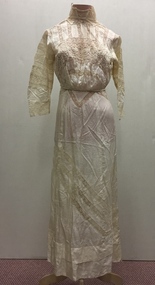
Clothing - Silk & Lace Lingerie Dress, 1900s
An item forming part of a collection of costumes, photographs and documents relating to the Weir family who lived in the mansion originally named Illapa, 84 Princess Street, Kew, from c.1917 to 1950. This historically significant collection includes items relating to both George Weir (1866-1937) and his wife Edith Mary Weir (1867-1948). George Weir attained national prominence in the mining industry, becoming General Manager of the North Broken Hill Silver Mining Company in 1903 (later renamed North Broken Hill Mining Company 1905-12, and North Broken Hill Ltd 1912-1988), and subsequently President of the Mine Owners Association. He was to remain General Manager of North Broken Hill Ltd until his retirement in 1926.This garment is part of a collection of women’s clothing, owned and worn by Edith Mary Weir (nee Betteridge) - born in Clare, South Australia 1867, died Kew 1948 - and also by her daughter. The garments date from the 1880s to the 1930s. The collection includes day dresses, evening dresses, evening coats, capes, and undergarments. As the wife and daughter of a mine manager, the collection includes representative examples of clothing worn by upper middle class Australian women in domestic circumstances, and at social and civic events. A number of the costumes from the 1920s to the 1930s are of a particularly fine quality, being both rare, representative and intact examples of Australian fashion of the period. The garments in the Weir Collection were donated to the Kew Historical Society by a granddaughter of Edith Weir in 2017.Cream silk lingerie dress featuring wide inset panels of lace of the same colour. The bands of lace are of varying widths and appear on the bodice, the skirt and the sleeves. The dress is loose fitting but held at the waist by a silk cord. The lace yoke has a high neck. An initial assessment suggested that the buttons might be a later addition.edith mary weir (nee betteridge), 84 princess street - kew (vic), women's clothing, costumes, dresses - lingerie dresses, fashion - broken hill - 1900s -
Linton and District Historical Society Inc
Prize Ribbon, Mannibadar Gymkhana, 1954
Prize ribbon is part of a collection of judges' assessment cards, prize certificates and ribbons, awarded between 1953 and 1959 at the Mannibadar Gymkhana fleece competition to Percy (Ronald Percival) Howell of Mannibadar for his Corriedale sheep fleeces.Royal blue felt ribbon with yellow printed text.Text, printed: " Mannibadar Gymkhana 1954 "mannibadar gymkhana, percy (ronald percival) howell, prize certificates, prize ribbons, rural activity -
 Eltham District Historical Society Inc
Ledger, Eltham Road District. Assessment for the Year ending Oct. 14th, 1859, 1858c
The Eltham Roads Board was established in 1856. This ledger includes the signature of Road Board Secretary and Collector Wingrove, a significant person in Eltham's early history. This is a unique significant record of early settlers in the Shire of Eltham. One of 6 early rate books. This is among the oldest items in the EDHS collection. An article in the Eltham and Whittlesea Shires Advertiser Friday 21 Nov 1941 Page 5 titled: District's Early History states: "The first rate book which is still in existence at the Shire Office is for the year ending October 14, 1858 and is probably the best record possible to indicate the development of the district. At the time properties were rated as follows: Cultivated land. 6d. per acre; pasture land, 1d. per acre: estimated annual value of buildings, etc., 6d in the (pound). The total amount of rate recorded for the year was (pounds)153/14/8. Properties were described as being situated at Lower Plenty, Yarra Yarra, Eltham, Lower Eltham, Kangaroo Ground, Yarra Flats, Diamond Creek and the Yarra."Ledger with printed columns: Number, Name of Occupier, Description, Where situated, Cultivated land, Pasture land, Estimated annual value of buildings, Rate, Remarks, Arrears collected, excused, unoccupied, uncollected and amount actually collected. Ledger filled out by hand with 173 entries (not alphabetically arranged). A number of blank pages are included. Inside cover includes pasted printed note: RATE OF ASSESSMENT AS FOLLOWS: Cultivated land 6d per acre Pasture land 2d per acre Unalienated Pasture Land 8d per Acre Estimated Annual Value of Buildings, &c., 6d. in the Pound eltham roads board, rate book, rate payers, transaction, pioneers, settlers, wingrove, 1859, assessment ledger, eltham road district, public records office victoria (prov), rate books, shire of eltham archives -
 Eltham District Historical Society Inc
Ledger, Eltham Road District. Assessment for the Year ending Oct. 14th, 1860 (Version 1), 1859c
The Eltham Roads Board was established in 1856. This is a unique significant record of early settlers in the Shire of Eltham. One of 6 early rate books. This is among the oldest items in the EDHS collection. An article in the Eltham and Whittlesea Shires Advertiser Friday 21 Nov 1941 Page 5 titled: District's Early History states: "The first rate book which is still in existence at the Shire Office is for the year ending October 14, 1858 and is probably the best record possible to indicate the development of the district. At the time properties were rated as follows: Cultivated land. 6d. per acre; pasture land, 1d. per acre: estimated annual value of buildings, etc., 6d in the (pound). The total amount of rate recorded for the year was (pounds)153/14/8. Properties were described as being situated at Lower Plenty, Yarra Yarra, Eltham, Lower Eltham, Kangaroo Ground, Yarra Flats, Diamond Creek and the Yarra."Ledger with printed columns: Number, Name of Occupier, Description, Where situated, Cultivated land, Pasture land, Estimated annual value of buildings, Rate, Remarks, Arrears collected, excused, unoccupied, uncollected and amount actually collected. Ledger filled out by hand with 177 entries (not alphabetically arranged). A number of blank pages are included. Inside cover includes pasted printed note: RATE OF ASSESSMENT AS FOLLOWS: Cultivated land 6d per acre Pasture land 2d per acre Unalienated Pasture Land 8d per Acre Estimated Annual Value of Buildings, &c., 6d. in the Pound eltham roads board, rate book, rate payers, transaction, pioneers, settlers, wingrove, 1860, assessment ledger, eltham road district, public records office victoria (prov), rate books, shire of eltham archives -
 Eltham District Historical Society Inc
Ledger, Eltham Road District. Assessment for the Year ending Oct. 14th, 1860 (Version 2), 1859c
The Eltham Roads Board was established in 1856. This is a unique significant record of early settlers in the Shire of Eltham. One of 6 early rate books. This is among the oldest items in the EDHS collection. An article in the Eltham and Whittlesea Shires Advertiser Friday 21 Nov 1941 Page 5 titled: District's Early History states: "The first rate book which is still in existence at the Shire Office is for the year ending October 14, 1858 and is probably the best record possible to indicate the development of the district. At the time properties were rated as follows: Cultivated land. 6d. per acre; pasture land, 1d. per acre: estimated annual value of buildings, etc., 6d in the (pound). The total amount of rate recorded for the year was (pounds)153/14/8. Properties were described as being situated at Lower Plenty, Yarra Yarra, Eltham, Lower Eltham, Kangaroo Ground, Yarra Flats, Diamond Creek and the Yarra."Ledger with printed columns: Number, Name of Occupier, Description, Where situated, Cultivated land, Pasture land, Estimated annual value of buildings, Rate, Remarks, Arrears collected, excused, unoccupied, uncollected and amount actually collected. Ledger filled out by hand with 177 entries (not alphabetically arranged). A number of blank pages are included. This version was slight changes to version one. Inside cover includes pasted printed note: RATE OF ASSESSMENT AS FOLLOWS: Cultivated land 6d per acre Pasture land 2d per acre Unalienated Pasture Land 8d per Acre Estimated Annual Value of Buildings, &c., 6d. in the Pound eltham roads board, rate book, rate payers, transaction, pioneers, settlers, 1860, assessment ledger, eltham road district, public records office victoria (prov), rate books, shire of eltham archives -
 Eltham District Historical Society Inc
Ledger, Eltham Road District. Assessment for the Year ending Oct. 14th, 1861, 1860c
The Eltham Roads Board was established in 1856. This is a unique significant record of early settlers in the Shire of Eltham. One of 6 early rate books. This is among the oldest items in the EDHS collection. An article in the Eltham and Whittlesea Shires Advertiser Friday 21 Nov 1941 Page 5 titled: District's Early History states: "The first rate book which is still in existence at the Shire Office is for the year ending October 14, 1858 and is probably the best record possible to indicate the development of the district. At the time properties were rated as follows: Cultivated land. 6d. per acre; pasture land, 1d. per acre: estimated annual value of buildings, etc., 6d in the (pound). The total amount of rate recorded for the year was (pounds)153/14/8. Properties were described as being situated at Lower Plenty, Yarra Yarra, Eltham, Lower Eltham, Kangaroo Ground, Yarra Flats, Diamond Creek and the Yarra."Ledger with printed columns: Number, Name of Occupier, Description, Where situated, Cultivated land, Pasture land, Estimated annual value of buildings, Rate, Remarks, Arrears collected, excused, unoccupied, uncollected and amount actually collected. Ledger filled out by hand with 185 entries (not alphabetically arranged) and summary section. A number of blank pages are included. Inside cover includes pasted printed note: RATE OF ASSESSMENT AS FOLLOWS: Cultivated land 6d per acre Pasture land 2d per acre Unalienated Pasture Land 8d per Acre Estimated Annual Value of Buildings, &c., 6d. in the Pound eltham roads board, rate book, rate payers, transaction, pioneers, settlers, 1861, assessment ledger, eltham road district, public records office victoria (prov), rate books, shire of eltham archives -
Federation University Historical Collection
Booklet, Ballarat School of Mines Botanical Gardens Conservation/Restoration Management Plan
A Conservation/Restoration Management Plan for the Ballarat School of Mines Botanical Gardens. The report includes a planting timeline of the plants included in the gardens from 1850. Historical plans and maps are detailed from 1857 up to the site assessment in 2008.Printed report stapled at top left corner.Lisa Palmer written at top right corner in pencil.smb, school of mines ballarat, ballarat school of mines, botanical gardens, smb botanical gardens, conservation, restoration, ballarat school of mines garden, von mueller garden, ferdinand von mueller, botany, living collections, horticulture, gardens -
Vision Australia
Text, Royal Victorian Institute for the Blind Burwood register, 1977-1989
Young clients with vision impairment or blindness require various types of educational support. This register provides listings of the name, address, date of birth, H.O.D. date, referred by whom, diagnosis and assessment programme recommended by the RVIB Visiting Teachers.1 v.rvib burwood school -
Vision Australia
Audio (item) - Sound recording, Royal Victorian Institute for the Blind, Around the Institute: September 7, 2004
Around the Institute was a weekly program consisting of interviews around a specific topic, undertaken by host Corey Nassau. September 7: Technology updates – Jim Pipczak, Vision assessment with people who have an intellectual disability – Ruth Nicholson. royal victorian institute for the blind, radio shows -
 Bendigo Historical Society Inc.
Document - KANGAROO FLAT GOLD MINE COLLECTION: MEMO TO SANDNER FROM WILLMAN
Two page memo 17 January 1984, to R. Sandner, D. Cahill, R. Cameron, P.Vail and D. Andrew from C.E. William. Topics covered: Deborah lease project; Brunswick Mine Costerfield, E.L's 1397 and 1398; town planning permit application; historical research and geological assessment, dewatering programme.bendigo, gold mining, deborah lease project -
Port Melbourne Historical & Preservation Society
Book - Town of Port Melbourne Valuation 1899, 1899
Valuation book, Town of Port Melbourne 1899. Dark grey with maroon spine and label gold-stamped. 71 spreads completed, listing name and occupation of tenant and owner of each property, description, number of rooms, size of property, rental etc. p72/3 removed, folded and placed in p73. (also Rates; assessments)"page 72-73 out for printers copy 29/9/00 ECC" on p73 Separate printers copy has order/instruction for next book in pencil, various markings on pages in pencil and in red ink (the latter indicating cross streets) Signed by Mayor, Town Clerk and an unidentifiable Councillorlocal government, built environment, joseph turner, edward c crockford, town clerks, henry norval edwards -
Port Melbourne Historical & Preservation Society
Book - Town of Port Melbourne Valuation 1904-05, 1904
Valuation book, Town of Port Melbourne 1904-05. Dark blue green textured leatherette cover, maroon spine both gold stamped with title. 78 spreads completed, listing name and occupation of tenant and owner of each property, description, number of rooms, size of property, rental etc. (also Rates; assessments)Cross streets inserted in red ink, pencil indications in margins. On final spread pencil alteration to valuers statement.local government - city of port melbourne, joseph turner, built environment - civic -
 Bendigo Historical Society Inc.
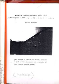
Book - STRAUCH COLLECTION: GREIFFENHAGENS CELLAR (HERCYNIA VINEYARD)
"Hercynia" was the largest vineyyard in the Bendigo District. It was started by Carl Wilhelm Greiffenhagen (William) and his cousins, twins, Carl and August Heine. The first vine cuttings were planted in 1860. The partners owned 300 acres at Axe Creek and in 1862 had 24 acres under vines and an orchard of 4 acres. By 1884 they had expanded to 30 acres of vines. They produced many award winning wines. August Heine ( 1832 - 1898) was born in Germany and came to Australia in 1854 with his twin brother Carl and their cousin William Greiffenhagen. Initially the three took up mining successfully but then the partnership bought 300 acres at Axe Creek and planted a vineyard. They also grew fruit and crops to feed the working horses. In 1870 August sold his interest in the vineyard and set up his own smaller vineyard at Sheepwash Gully. He had several business interests before he took up the caretaker position at the newly dug Weeroona lake, a position he held until his death. Carl Heine sold his interest in the vineyard in 1873 and returned to Germany. WIlliam Grieffenhagen (1834-1916) continued his very successful vineyard until the region was hit with a highly infectious vine disease in 1893. Although his own vines escaped infection, he was within the 2 mile quarantine area and was forced to dig out all his vines. He never replanted but depended on his orchard instead. He was a founding member of the Bendigo Agricultural Society and a local Shire councillor for several years. In 1870 he married Margaret Boyd.Binder containing information relating to Greiffenhagen's cellar (Hercynia Vineyard) 1860 - 1991 including black and white photographs & maps, compiled by John Houlahan as a third year thesis whichnis pat of the assessment for a Bachelor of Arts (Social Science) degree. Donated to the German Society 15/2/96 by the Grandfather of author Jack Houlahan.John Houlahanbook, bendigo, wineries, bendigo-history-axe creek- wineries- german -
 Greensborough Historical Society
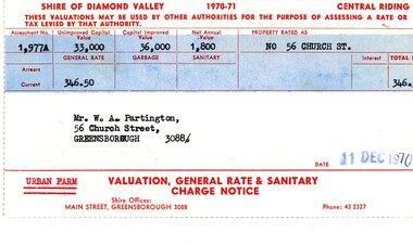
Financial record - Account, Shire of Diamond Valley, Shire of Diamond Valley rates notices 1970-1971, 26/03/1958
Shire of Diamond Valley Rates assessment issued to Alan Partington in 1970. This land is assessed as an "Urban Farm". In 1974 the 'farm rate' was declined for this property, eventually leading to its acquisition by the Shire for recreational space, now known as Whatmough Park.Part of the property owned by the Partington family in the original Greensborough farmland. Rates notice, printed in red text with black typed details.Date stamped with rubber stampalan partington, william alan partington, partington family, land deals greensborough, church street greensborough, whatmough park -
Bialik College
Mixed media (Item) - 2006 Student Artwork Images Year 9-12, Student Artwork Images Year 9-12
Student artwork created for assessment at Bialik College during the school year of 2006. This material was created by students from Year 9, Year 10, Year 11, and Year 12. Please contact [email protected] to request access to this record.Bialik College Student Artwork images2000s, 2007, 2006, artwork, creative arts, year 9, year 10, year 11, year 12 -
Bendigo Historical Society Inc.
Map - CAMPBELL COLLECTION: BENDIGO AND DISTRICT MAPS
Map. Ascot, Parishes of Huntly, Sandhurst and Wellsford. Scale 20 chains to 1 inch. Total area 2818 acres. To Bendigo 4 1/2 miles, to Epsom 3/4 mile, Huntly 3/4 mile. Prepared in W.P.B. from Assessment Plans and Parish Plans. (number 380 in map cupboard 1)map, bendigo, agricultural lands -
Port Melbourne Historical & Preservation Society
Book - Borough of Sandridge Valuation 1864-5, 1864
Valuation Book, 1864 Borough of Sandridge. Brown cover, red binding and label embossed in gold. 105 pages entered, listing name and occupation of tenant and owner of each property, description, number of rooms, size of property, rental etc. Blue paper insert at front, starting value of each block, and total. (also Rates; assessments)local government - borough of sandridge, built environment, william francis westall, john edward crockford, william may -
Port Melbourne Historical & Preservation Society
Book - Borough of Sandridge Valuation 1881, 1881
Valuation Book, Borough of Sandridge 1881. 119 spreads (+ summary on 134) listing name and occupation of tenant and owner of each property, description, number of rooms, size of property, rental etc. Dark French blue cloth cover, tan suede corners and spine with red, gold-stamped spine label (also Rates; assessments)Note in ink back of front endpaper 'No 1098 Omitted' Date inked lower left coverlocal government - borough of sandridge, built environment, william cruikshank, frederick peterson -
Port Melbourne Historical & Preservation Society
Book - Borough of Sandridge Valuation 1877, 1876
Valuation Book, Borough of Sandridge 1877. Reddish marbled cover with tan leather spine and corner bindings, red leather, goldstamped, red label on spine. 127 spreads listing name and occupation of tenant and owner of each property, description, number of rooms, size of property, rental etc., plus p128 (also Rates; assessments)Signed by Town Clerk and Mayor as well as valuers; '1877-78' in ink lower left of cover (90 degrees)local government - borough of sandridge, built environment, frederick peterson, william cruikshank, edward clark, town clerks, john turnbull -
Port Melbourne Historical & Preservation Society
Book - Borough of Sandridge Valuation 1875, 1875
Valuation Book, Borough of Sandridge 1875. Bluegreen with red leather, and tan leather spine and corner bindings, gold-stamped label. 116 spreads used (but also entries on 117 and 126) listing name and occupation of tenant and owner of each property, description, number of rooms, size of property, rental etc. (also Rates; assessments) Notation on back of front endpaperlocal government - borough of sandridge, built environment, frederick peterson, william cruikshank -
Port Melbourne Historical & Preservation Society
Book - Borough of Port Melbourne Valuation 1894, 1894
Valuation book, Borough of Port Melbourne 1894. Tan marbled cover, maroon spine and gold-stamped label. Pages buff (index to blocks p. 89). 76 spreads completed listing name and occupation of tenant and owner of each property, description, number of rooms, size of property, rental etc. (also Rates; assessments) Printed years "1893-94" overwritten with 1894-95 on all used pages.local government, built environment, joseph turner -
 Eltham District Historical Society Inc
Ledger, Eltham Road District. Assessment for the Year ending Oct. 14th, 1862, 1861c
The Eltham Roads Board was established in 1856. This is a unique significant record of early settlers in the Shire of Eltham. One of 6 early rate books. This is among the oldest items in the EDHS collection. An article in the Eltham and Whittlesea Shires Advertiser Friday 21 Nov 1941 Page 5 titled: District's Early History states: "The first rate book which is still in existence at the Shire Office is for the year ending October 14, 1858 and is probably the best record possible to indicate the development of the district. At the time properties were rated as follows: Cultivated land. 6d. per acre; pasture land, 1d. per acre: estimated annual value of buildings, etc., 6d in the (pound). The total amount of rate recorded for the year was (pounds)153/14/8. Properties were described as being situated at Lower Plenty, Yarra Yarra, Eltham, Lower Eltham, Kangaroo Ground, Yarra Flats, Diamond Creek and the Yarra."Ledger with printed columns: Number, Name of Occupier, Description, Where situated, Cultivated land, Pasture land, Estimated annual value of buildings, Rate, Remarks, Arrears collected, excused, unoccupied, uncollected and amount actually collected. Ledger filled out by hand with 184 entries (not alphabetically arranged) and summary section. A number of blank pages are included. Inside cover includes pasted printed note: RATE OF ASSESSMENT AS FOLLOWS: Cultivated land 6d per acre Pasture land 1/2d per acre Unalienated Pasture Land 1/28 per Acre Estimated Annual Value of Buildings, &c., 6d. in the Pound eltham roads board, rate book, rate payers, transaction, pioneers, settlers, 1862, assessment ledger, eltham road district, public records office victoria (prov), rate books, shire of eltham archives -
 Eltham District Historical Society Inc
Ledger, Eltham Road District. Assessment for the Year ending Oct. 14th, 1863, 1862c
The Eltham Roads Board was established in 1856. This is a unique significant record of early settlers in the Shire of Eltham. One of 6 early rate books. This is among the oldest items in the EDHS collection. An article in the Eltham and Whittlesea Shires Advertiser Friday 21 Nov 1941 Page 5 titled: District's Early History states: "The first rate book which is still in existence at the Shire Office is for the year ending October 14, 1858 and is probably the best record possible to indicate the development of the district. At the time properties were rated as follows: Cultivated land. 6d. per acre; pasture land, 1d. per acre: estimated annual value of buildings, etc., 6d in the (pound). The total amount of rate recorded for the year was (pounds)153/14/8. Properties were described as being situated at Lower Plenty, Yarra Yarra, Eltham, Lower Eltham, Kangaroo Ground, Yarra Flats, Diamond Creek and the Yarra."Ledger with printed columns: Number, Name of Occupier, Description, Where situated, Cultivated land, Pasture land, Estimated annual value of buildings, Rate, Remarks, Arrears collected, excused, unoccupied, uncollected and amount actually collected. Ledger filled out by hand with 181 entries (not alphabetically arranged) and summary section. A number of blank pages are included. Inside cover includes pasted printed note: RATE OF ASSESSMENT AS FOLLOWS: Cultivated land 6d per acre Pasture land 1/2d per acre Unalienated Pasture Land 1/28 per Acre Estimated Annual Value of Buildings, &c., 6d. in the Pound eltham roads board, rate book, rate payers, transaction, pioneers, settlers, 1863, assessment ledger, eltham road district, public records office victoria (prov), rate books, shire of eltham archives -
Glen Eira Historical Society
Document - Alnwick, Railway Parade,|11-11A,|Murrumbeena
A Caulfield conservation study on ‘Alnwick’, 11 Railway Parade, Murrumbeena, including a description of the exterior of the house and a brief history of the life of its owner, Sir James Brown Patterson. Also includes a statement of significance for Alnwick. Assessment by Andrew Ward dated to March, 1995.railway parade, patterson james, architectural styles, patterson james sir, alnwick, victorian style, murrumbeena -
University of Melbourne, Burnley Campus Archives
Work on paper (item) - Student Work, Laura Batch, Construction Issue Mr and Mrs Campbell, 2018
Was submitted as an assignment at Burnley Horticultural Campus, likely for the subject HORT90035 coordinated by Andrew Laidlaw, as it was found with many other projects carried out for this subject. One of the pockets contained an envelope with a medical certificate for Laura Batch, presumably to get an extension on the assessment. This was disposed of for privacy. -
 Bendigo Historical Society Inc.
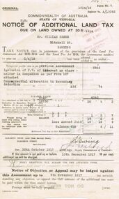
Document - GLENYS MCKITTERICK COLLECTION: WILLIAM BEEBE DOCUMENTS, 1st June 1915
Notice of Additional Land Tax due on land owned at 30/6/1914, Mr William Beebe Mitchell St Bendigo. A/10062. Notification 1/6/15. Previous Assessment Inclusion of U.V. of interest as share - holder in Companies as per Form 107.Due date 10th October 1917, signed by Deputy Commissioners Ewing and Eastford.person, bendigo, william beebe, beebe, land tax -
 Bendigo Historical Society Inc.
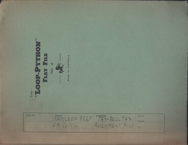
Document - MCCOLL, RANKIN AND STANISTREET COLLECTION: NAPOLEON REEF GOLD MINING CO. N.L, 1941-1950
Documents: Napoleon Reef Gold Mining Co Pay Roll Tax Assessment File, Loop Python Flat File containing Payroll Tax Exemption Certificates and Return of Wages Paid (Annual) from 1941 - 1950, Also a Payroll Tax Refund notification dated 3 March 1944, Markings: File Name written in ink on front cover.organization, business, industrial - mining, mccoll rankin & stanistreet, mining, gold mining, napoleon reef