Showing 1616 items
matching borough
-
 Ringwood and District Historical Society
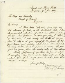
Letter, Letter from N Madden to Mayor and Councillors , Borough of Ringwood. 1937
Hand written letterLetter is from N.Madden -Coach and Horses Hotel, to the Ringwood Borough Council, dated 9th June 1937. Contents regarding Allotments of land in the Heatherdale Station Estate. -
 Ballarat Tramway Museum
Legal record - Agreement - ESCo & Borough of Sebastopol, Electric Supply Co of Vic. (ESCo), 12/1912
Agreement between the Electric Supply Co of Victoria and the Borough of Sebastopol for the electrification and reconstruction of the Sebastopol tram line, dated 12/12/1912. Sets out the terms and conditions for the work and operations. Signed by Thomas Dickinson, May, H Clark Councilor and Johnathan R Wall Town Clerk and W M Knox, ESCo Accountant. Prepared by Home & Wilkinson of 412 Collins St Melbourne.Yields information about the construction of the Sebastopol electric line.Document - agreement - 6 typed sheets, part stapled, folded vertically.tramways, agreements, esco, sebastopol, borough of sebastopol -
 Ringwood and District Historical Society
Document, City of Ringwood - re-enactment of Borough of Ringwood meeting dated 24th December, 1924
Typed documentsMeeting of City of Ringwood Council held 19th November, 1984, for re-enactment of Borough of Ringwood meeting dated 1924. Meeting chaired by the Mayor Cr. R. Gardini. -
 Ringwood and District Historical Society
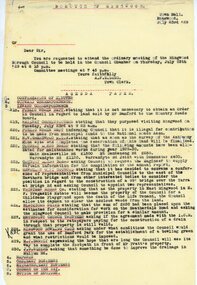
Document, From Borough of Ringwood Council, agenda for next council meeting on 23 July 1929
1929 saw the establishment of the Ringwood Bowls Club initially located on the land now occupied by the Eastland Shopping Centre. It moved to its current location in Loughnan Road, Ringwood in 1997.From Borough of Ringwood Council, agenda for next council meeting on 23 July 1929. Ringwood Bowling Club requesting conditions for use of Bamford Park as a bowling green.city of ringwood bowls club, ringwood bowling club, ringwood bowls club, lawn bowls, bowling -
Ringwood and District Historical Society
Indenture Papers, Typed document formalising separation of Borough of Ringwood from Shire of Lillydale - 25 October 1926, Oct-26
These comprise a bundle of papers pertaining to the Indenture made between the council of the Lillydale Shire and the council of the Borough of Ringwood, and the apportioning of property, income, assets, rights, liabilities and expenses, etc.Various council matters between Ringwood and Lilydale. These comprise 44 foolscap pages - some typed, some handwritten. -
 Greensborough Historical Society
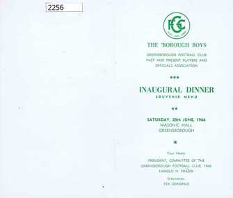
Menu, Greensborough Football Club, The 'Borough Boys: Inaugural dinner souvenir menu, 25/06/1966
Menu for The 'Borough Boys (Greensborough Football Club Past and Present Players and Officials Association) Inaugural Dinner, held Saturday 25th June 1966, Masonic Hall Greensborough.Green print on white cardboard, folded into 4 page bookletgreensborough football club -
Stawell Historical Society Inc
Map, Department of Lands and Survey, Borough of Stawell. Parishes of Stawell and Illawarra 1903, 1903
Victoria Co., St Georges Co., Wimerra Co., Leviathon Co. Tramway, Quarry reserve, Newington Co., Galatea Co., Moonlight Co., Federal Co., Borough reservior., A0 Map of Stawell on linen backing. Plus one Printed on PaperPhoto Lithograped at the Department of Lands and survey Melbourne by T.F. McGauran 13.6.03surevy -
Stawell Historical Society Inc
Map, Borough of Stawell Parish of Stawell and Illawarra 10/06/1903, 10/06/1903
Department of Lands and Survey Map of Stawell with marked roads, allotments, physical landmarks. Found in Storage at ANZ Bank when the old archive was being cleaned out. Also shows Surveyed but unused roads. Showed where customers lived in StawellPholtolithograph Map - Paper on canvas backingBorough of Stawell. Parish of Stawell and Illawarra. County of Borong. Scale 8 Chains to 1 Inch. Scale 16 Chains to 1 Inch. Red Ink Writing, Purple and Blue.town -
Federation University Historical Collection
Map, City of Ballarat and Borough of Sebastopol Road Map
Road map of the City of Ballarat and the Borough of Sebastopol. WGS 85 Centroid 37 degrees 33 feet 56 inches south 143 degrees 51 feet 09 inches eat E-W- extent: 9 km N-S- extent: 11.5 kmballarat, sebastopol, map, plan, ballarat shire -
Port Melbourne Historical & Preservation Society
Book, Borough of Sandridge Workmen's Time Book, 1864
Record of workmen and work done in the Borough of Sandridge from Feb 24, 1864 to June 26, 1866. Details include occupation (e.g carter, foreman), location, actual work done each day, rate of pay, amount paid. Index of names of workmen and location at the front.local government - borough of sandridge -
 Ringwood and District Historical Society
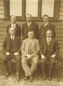
Photograph, Ringwood Borough Council - 1931
Written on back of black and white photograph, "Ringwood Borough Council - 1931. Standing left to right: J. McCaskill, J.G. Aird, R.W. Davies. Sitting: A.T. Miles, A. Blood, A. Ibbotson". -
 Ringwood and District Historical Society
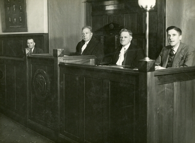
Photograph, Alfred Seale, Ringwood Borough Council, circa 1935 - 1948, Mayor JK McCaskill
Ringwood Borough Council 1945 in Council Chambers, Les Bray - Engineer, J. McCaskill - Mayor, A.F.B. Long - Town Clerk, J. Grenfell - Rate Collector +Additional Keywords: Bray, Les / McCaskill, J. / Long, A.F.B. / Grenfell, J. / Seale, Alfred / Purser, E.T. (Mrs) -
 Ringwood and District Historical Society
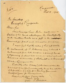
Letter, From Philip Bamford to Borough of Ringwood gifting a parcel of land for park and recreation purposes
1929 saw the establishment of the Ringwood Bowls Club initially located on the land now occupied by the Eastland Shopping Centre. It moved to its current location in Loughnan Road, Ringwood in 1997.Hand-written letter from Philip Bamford to To Borough of Ringwood's Town Clerk giving a parcel of land for park and recreation purposes. Probable site for bowling green and croquet lawn. The land would adjoin similar donation from Capt Miles [Miles Park]. Dated 18th October 1926.city of ringwood bowls club, ringwood bowling club, ringwood bowls club, lawn bowls, bowling -
 Ringwood and District Historical Society
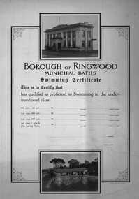
Certificate, Borough of Ringwood- Municipal Baths. Swimming Certificate c1950's
Swimming Certificate for the Borough of Ringwood Municipal Baths. Proficient in swimming in 66 yards, 200 yards, and 400 yards and 1 mile and Life Saving Tests. Two good B&W pictures of Town Hall and pool.Sample swimming certificate, cardboard, with two B&W pictures on it. At the top is a picture of the old Ringwood Town Hall, and at the bottom a picture of the Ringwood outdoor swimming pool and building. -
Port Melbourne Historical & Preservation Society
Book, Margaret Bride et al, The Borough and Its People, 2013
The Borough and Its People. 1839 -1939 Port Melbourne Book with blue front cover and narrow band of 5 photos 3to 5 cms from top. Back cover similar in layout plus description of book's theme and contents . PMHPS logo and Port Phillip Council logo on back cover.australian aborigines, built environment, armed services, maritime, melbourne and metropolitan board of works, arts and entertainment, piers and wharves, transport, natural environment, transport - aviation and aerodrome, advertising, built environment - commercial, celebrations fetes and exhibitions, religion, industry, engineering, education, families, garden city, sandridge lagoon, politics, sport, margaret bride nee polson, graham bride -
Port Melbourne Historical & Preservation Society
Essay - Honours Thesis, Rosie BRAY, Rosalie (Rosie) Thrupp Robnson Bray, "The Borough", 2010
Copy of thesis submitted as part of the final honours examination in the History program at LaTrobe University. Copy bound and donated by the author."The Borough", by Rosie BRAY 2010. Honours Thesis, History program, LaTrobe University, which discusses the experiences of Port Melbourne's people in World War Two and includes information from interviews with people who lived through the war and the author's own memories . Bound in red and blue, with gold print on the cover.war - world war ii, rosalie (rosie) bray nee thrup -
 Ballarat Tramway Museum
Administrative Record - Meeting Minutes, State Electricity Commission of Victoria (SECV), the SEC and the City of Ballarat and Borough of Sebastopol, Oct. 1929
Demonstrates a consultation process and yields information about the process that saw the eventual take over of the ESCo and MESCo tramways by the SECMinutes - 23 carbon copy foolscap sheets - minutes or transcript of a meeting between the SEC and the City of Ballarat and Borough of Sebastopol 28/10/1929 to regarding the SEC take over and agreements with the locals councils, pending authorisation by Parliament. Sir John Monash led the SEC group Has a list of attendees. trams, tramways, minutes, sec, geelong, ballarat, bendigo, city of ballaarat, borough of sebastopol -
 Ringwood and District Historical Society
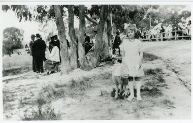
Photograph, Celebration at sports oval - Ringwood declared a Borough on 13 December 1924
Black and white photo showing Violet Strachan and lamb at celebrations'Written on back of photograph" Little Violet Strachan represented 'Mary Had a Little Lamb' at celebrations at Sports Oval. Ringwood declared a Borough on 13 December 1924. Photo taken by Miss Linda Pump (Mrs Cuthill) -
 Kew Historical Society Inc
Plan, Melbourne & Metropolitan Board of Works : Borough of Kew : Detail Plan No.1592, 1905
The Melbourne and Metropolitan Board of Works (MMBW) plans were produced from the 1890s to the 1950s. They were crucial to the design and development of Melbourne's sewerage and drainage system. The plans, at a scale of 40 feet to 1 inch (1:480), provide a detailed historical record of Melbourne streetscapes and environmental features. Each plan covers one or two street blocks (roughly six streets), showing details of buildings, including garden layouts and ownership boundaries, and features such as laneways, drains, bridges, parks, municipal boundaries and other prominent landmarks as they existed at the time each plan was produced. (Source: State Library of Victoria). This plan forms part of a large group of MMBW plans and maps that was donated to the Society by the Mr Poulter, City Engineer of the City of Kew in 1989. Within this collection, thirty-five hand-coloured plans, backed with linen, are of statewide significance as they include annotations that provide details of construction materials used in buildings in the first decade of the 20th century as well as additional information about land ownership and usage. The copies in the Public Record Office Victoria and the State Library of Victoria are monochrome versions which do not denote building materials so that the maps in this collection are invaluable and unique tools for researchers and heritage consultants. A number of the plans are not held in the collection of the State Library of Victoria so they have the additional attribute of rarity.Original survey plan, issued by the MMBW to a contractor with responsibility for constructing sewers in the area identified on the plan within the Borough of Kew. The plan was at some stage hand-coloured, possibly by the contractor, but more likely by officers working in the Engineering Department of the Borough and later Town, then City of Kew. The hand-coloured sections of buildings on the plan were used to denote masonry or brick constructions (pink), weatherboard constructions (yellow), and public buildings (grey). In MMBW Plan No.1592, the pink line indicates that area of the plan for which the contracting engineer was responsible. Included in the Plan are a number of primarily brick villas in a section of Belmont Avenue off Cotham Road. The house ‘Uvadale’ north of Belmont Avenue, and facing Cotham Road is also included in the contract. Excluded from the contract but shown on the Plan are ‘Glendonald’, ‘Mont Belmont’ and ‘Gilden’.melbourne and metropolitan board of works, detail plans, survey plans - borough of kew, mmbw 1592, cartography -
 Kew Historical Society Inc
Plan, Melbourne & Metropolitan Board of Works : Borough of Kew : Detail Plan No.1561, 1905
The Melbourne and Metropolitan Board of Works (MMBW) plans were produced from the 1890s to the 1950s. They were crucial to the design and development of Melbourne's sewerage and drainage system. The plans, at a scale of 40 feet to 1 inch (1:480), provide a detailed historical record of Melbourne streetscapes and environmental features. Each plan covers one or two street blocks (roughly six streets), showing details of buildings, including garden layouts and ownership boundaries, and features such as laneways, drains, bridges, parks, municipal boundaries and other prominent landmarks as they existed at the time each plan was produced. (Source: State Library of Victoria). This plan forms part of a large group of MMBW plans and maps that was donated to the Society by Mr Poulter, City Engineer of the City of Kew in 1989. Within this collection, thirty-five hand-coloured plans, backed with linen, are of statewide significance as they include annotations that provide details of construction materials used in buildings in the first decade of the 20th century as well as additional information about land ownership and usage. The copies in the Public Record Office Victoria and the State Library of Victoria are monochrome versions which do not denote building materials so that the maps in this collection are invaluable and unique tools for researchers and heritage consultants. A number of the plans are not held in the collection of the State Library of Victoria so they have the additional attribute of rarity.Original survey plan, issued by the MMBW to a contractor with responsibility for constructing sewers in the area identified on the plan within the Borough of Kew. The plan was at some stage hand-coloured, possibly by the contractor, but more likely by officers working in the Engineering Department of the Borough and later Town, then City of Kew. The hand-coloured sections of buildings on the plan were used to denote masonry or brick constructions (pink), weatherboard constructions (yellow), and public buildings (grey). MMBW Detail Plan 1561 outlines those residences in the area bordered by Burke Road, Loxton Street, Mount Street and Barkers Road that had been constructed by 1905 when the land was surveyed. At this time, the area nearest Burke Road had been subdivided and developed whereas the lands to the west were as yet undeveloped. The houses represented are not named on the Plan.melbourne and metropolitan board of works, detail plans, mmbw 1561, cartography -
Port Melbourne Historical & Preservation Society
Book - Borough of Port Melbourne, Rough Minute Book . Borough of Port Melbourne 03/05/1892 to 06/04/1893, 1892
Rough Minute Book . Borough of Port Melbourne 03/05/1892 to 06/04/1893. Written and printed. White label on front. Red, blue, black and white "marbling" cover with red spine. Rough Minute label on back cover also. Other rough minute books from period catalogued in series 3685 to 3693, also 1107local government - borough of port melbourne, built environment, edward c crockford, town clerks -
 Ringwood and District Historical Society
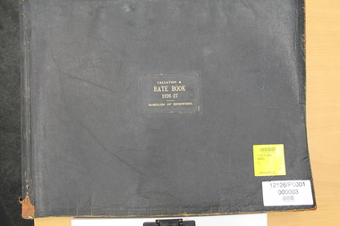
Administrative record - Parent Record, Borough of Ringwood Rate Books for 1924-49
The rate books are a primary source about Ringwood ratepayers, as well as indicating street and estate names.This is the parent record for the Borough of Ringwood Rate Book collection. The VC Reference Number range 33001-34999 has been reserved. The Borough of Ringwood was created in December 1924, formally part of the South-West riding of the Shire of Lillydale. Ringwood was proclaimed a city on 19 March 1960. On 15 December 1994, the City of Ringwood was amalgamated to form part of Maroondah City Council. The detailed years are: 1924-25, 1926-27, 1928-29, 1930-31, 1932-34, 1934-35 and 1944-49. For researchers, the rate books are in assessment number sequence. Occasionally, they is also in surname or estate sequence but do not rely on this. The original records are kept at PROV, North Melbourne. At 13/3/2021 the bulk of the collection is being processed ready for a bulk load to Victorian Collections. Digitised by Mark Grealy c/o Archival Access Victoria (www.archivalaccessvictoria.com)rate book, borough of ringwood, rates, street names, ratepayers -
 Kew Historical Society Inc
Plan, Melbourne & Metropolitan Board of Works : Borough of Kew : Detail Plan No.1302, 1910
The Melbourne and Metropolitan Board of Works (MMBW) plans were produced from the 1890s to the 1950s. They were crucial to the design and development of Melbourne's sewerage and drainage system. The plans, at a scale of 40 feet to 1 inch (1:480), provide a detailed historical record of Melbourne streetscapes and environmental features. Each plan covers one or two street blocks (roughly six streets), showing details of buildings, including garden layouts and ownership boundaries, and features such as laneways, drains, bridges, parks, municipal boundaries and other prominent landmarks as they existed at the time each plan was produced. (Source: State Library of Victoria)This plan forms part of a large group of MMBW plans and maps that was donated to the Society by the Mr Poulter, City Engineer of the City of Kew in 1989. Within this collection, thirty-five hand-coloured plans, backed with linen, are of statewide significance as they include annotations that provide details of construction materials used in buildings in the first decade of the 20th century as well as additional information about land ownership and usage. The copies in the Public Record Office Victoria and the State Library of Victoria are monochrome versions which do not denote building materials so that the maps in this collection are invaluable and unique tools for researchers and heritage consultants. A number of the plans are not held in the collection of the State Library of Victoria so they have the additional attribute of rarity.Original survey plan, issued by the MMBW to a contractor with responsibility for constructing sewers in the area identified on the plan within the Borough of Kew. The plan was at some stage hand-coloured, possibly by the contractor, but more likely by officers working in the Engineering Department of the Borough and later Town, then City of Kew. The hand-coloured sections of buildings on the plan were used to denote masonry or brick constructions (pink), weatherboard constructions (yellow), and public buildings (grey). The absence of buildings and or property in Kew facing the Yarra is the most notable feature of this plan. Walmer Street and its bridge stretched, then and now, from Studley Park Road to Victoria Street, Richmond. On the Richmond side of the Yarra, there was evidence in 1904 of industry (‘Wool shed’; Soap Works’) and entertainment (‘Skittle Alley’). In reality, another Plan (No.1303) shows Chinese Gardens bordering the Yarra on the Kew side and buildings in Young Street.melbourne and metropolitan board of works, detail plans, mmbw 1302, cartography -
 Kew Historical Society Inc
Plan, Melbourne & Metropolitan Board of Works : Borough of Kew : Detail Plan No.1571, 1904
The Melbourne and Metropolitan Board of Works (MMBW) plans were produced from the 1890s to the 1950s. They were crucial to the design and development of Melbourne's sewerage and drainage system. The plans, at a scale of 40 feet to 1 inch (1:480), provide a detailed historical record of Melbourne streetscapes and environmental features. Each plan covers one or two street blocks (roughly six streets), showing details of buildings, including garden layouts and ownership boundaries, and features such as laneways, drains, bridges, parks, municipal boundaries and other prominent landmarks as they existed at the time each plan was produced. (Source: State Library of Victoria)This plan forms part of a large group of MMBW plans and maps that was donated to the Society by the Mr Poulter, City Engineer of the City of Kew in 1989. Within this collection, thirty-five hand-coloured plans, backed with linen, are of statewide significance as they include annotations that provide details of construction materials used in buildings in the first decade of the 20th century as well as additional information about land ownership and usage. The copies in the Public Record Office Victoria and the State Library of Victoria are monochrome versions which do not denote building materials so that the maps in this collection are invaluable and unique tools for researchers and heritage consultants. A number of the plans are not held in the collection of the State Library of Victoria so they have the additional attribute of rarity.Original survey plan, issued by the MMBW to a contractor with responsibility for constructing sewers in the area identified on the plan within the Borough of Kew. The plan was at some stage hand-coloured, possibly by the contractor, but more likely by officers working in the Engineering Department of the Borough and later Town, then City of Kew. The hand-coloured sections of buildings on the plan were used to denote masonry or brick constructions (pink), weatherboard constructions (yellow), and public buildings (grey). This plan is the other half of Plan No.1571 representing the constructions to the west of Wellington Street before and in 1903/4. This plan represents the built environment in Edgevale Road, Wellington Street, Atkins Street, Annadale Street, Mortimer Street, and Cotham Road. Whereas there are smaller allotments and more modest housing stock facing Edgevale Road, larger blocks and more substantial houses are represented facing Cotham Road.melbourne and metropolitan board of works, detail plans, mmbw 1571, cartography -
 Kew Historical Society Inc
Plan, Melbourne & Metropolitan Board of Works : Borough of Kew : Detail Plan No.1575, 1905
The Melbourne and Metropolitan Board of Works (MMBW) plans were produced from the 1890s to the 1950s. They were crucial to the design and development of Melbourne's sewerage and drainage system. The plans, at a scale of 40 feet to 1 inch (1:480), provide a detailed historical record of Melbourne streetscapes and environmental features. Each plan covers one or two street blocks (roughly six streets), showing details of buildings, including garden layouts and ownership boundaries, and features such as laneways, drains, bridges, parks, municipal boundaries and other prominent landmarks as they existed at the time each plan was produced. (Source: State Library of Victoria)This plan forms part of a large group of MMBW plans and maps that was donated to the Society by the Mr Poulter, City Engineer of the City of Kew in 1989. Within this collection, thirty-five hand-coloured plans, backed with linen, are of statewide significance as they include annotations that provide details of construction materials used in buildings in the first decade of the 20th century as well as additional information about land ownership and usage. The copies in the Public Record Office Victoria and the State Library of Victoria are monochrome versions which do not denote building materials so that the maps in this collection are invaluable and unique tools for researchers and heritage consultants. A number of the plans are not held in the collection of the State Library of Victoria so they have the additional attribute of rarity.Original survey plan, issued by the MMBW to a contractor with responsibility for constructing sewers in the area identified on the plan within the Borough of Kew. The plan was at some stage hand-coloured, possibly by the contractor, but more likely by officers working in the Engineering Department of the Borough and later Town, then City of Kew. The hand-coloured sections of buildings on the plan were used to denote masonry or brick constructions (pink), weatherboard constructions (yellow), and public buildings (grey). Plan No.1575 shows that in the area bounded by Wellington Street, Edgevale Road, Glenferrie Road, and Cotham Road, there had already been significant subdivision of land and houses constructed. As one of the highest points in Kew, as expected, there were already some significant mansions built on large allotments of land. Many of these mansions are identified by name on the plan such as ‘Kelso’, ‘Abbotsford’, ‘Clarendon’ and ‘Ashlyn’ in Cotham Road. Other houses of equal size are unnamed on the plan.melbourne and metropolitan board of works, detail plans, maps - borough of kew, mmbw 1575, cartography -
 Flagstaff Hill Maritime Museum and Village
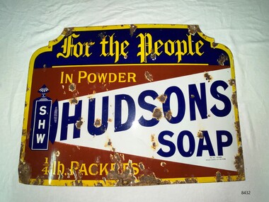
Sign - Hudson's Soap Enamel Advertising Sign, Patent Enamel Co Ltd, c. late 19th century- early 20th century
Hudson's Soap Powder, was the first satisfactory and commercially successful soap powder and was made in Liverpool by Robert Spear Hudson. He was also an innovator in using advertising, commissioning striking images from professional artists and paid for publicity , something which few other businesses did, and as such Hudson's soap became a household name. Horse, steam and electric tramcars, print periodicals and chemist shops carried his advertisements. This sign was manufactured by Patent Enamel Co Ltd was a company built in 1889 at Selly Oak, Borough of Birmingham, West Midlands, England, United Kingdom. The business was the first factory specifically devoted to enameled iron sign making. It had twelve furnaces for fusing the enamel, two scaling furnaces, and a large printing room, plus a huge area for steampipe drying. The company also smelted its own enamels and colour oxides. It is believed that the factory was decommissioned and demolished in the 1960's.the first factory specifically devoted to enameled iron sign making. It had twelve furnaces for fusing the enamel, two scaling furnaces, and a large printing room, plus a huge area for steampipe drying. The company also smelted its own enamels and colour oxides.The factory was decommissioned and demolished in the 1960s.The signage demonstrates the increasing demand for domestic soap products and new forms of advertising. The soap business was apart of the flourishing export trade between Australia and Britain during the height of the British Empire.Enamel advertising sign for Hudson's soapflagstaff hill, warrnambool, maritime museum, hudson's soap, advertising signage, patent enamel co ltd, selly oak, borough of birmingham, robert spear hudson -
 Port Fairy Historical Society Museum and Archives
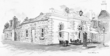
Photograph - Drawing, Sketch of Borough Chambers
Originally the Port Fairy Post Office built by Captain John Mason in 1865 in place of a wooden structure which he also built back in 1857. It then became the Port Fairy Borough Chambers in 1882 and the drawing shows the building inhabited by a Restaurant called "Lunch" c1990's. It is now the home of another Restaurant called 'Le Edera'.Black and white photograph of a drawing shop, commercial, borough chambers, borough council, port fairy, restaurant, 'lunch', 'le edera' -
 Kew Historical Society Inc
Plan, Melbourne & Metropolitan Board of Works : Borough of Kew : Detail Plan No.1576, 1904
The Melbourne and Metropolitan Board of Works (MMBW) plans were produced from the 1890s to the 1950s. They were crucial to the design and development of Melbourne's sewerage and drainage system. The plans, at a scale of 40 feet to 1 inch (1:480), provide a detailed historical record of Melbourne streetscapes and environmental features. Each plan covers one or two street blocks (roughly six streets), showing details of buildings, including garden layouts and ownership boundaries, and features such as laneways, drains, bridges, parks, municipal boundaries and other prominent landmarks as they existed at the time each plan was produced. (Source: State Library of Victoria)This plan forms part of a large group of MMBW plans and maps that was donated to the Society by the Mr Poulter, City Engineer of the City of Kew in 1989. Within this collection, thirty-five hand-coloured plans, backed with linen, are of statewide significance as they include annotations that provide details of construction materials used in buildings in the first decade of the 20th century as well as additional information about land ownership and usage. The copies in the Public Record Office Victoria and the State Library of Victoria are monochrome versions which do not denote building materials so that the maps in this collection are invaluable and unique tools for researchers and heritage consultants. A number of the plans are not held in the collection of the State Library of Victoria so they have the additional attribute of rarity.Original survey plan, issued by the MMBW to a contractor with responsibility for constructing sewers in the area identified on the plan within the Borough of Kew. The plan was at some stage hand-coloured, possibly by the contractor, but more likely by officers working in the Engineering Department of the Borough and later Town, then City of Kew. The hand-coloured sections of buildings on the plan were used to denote masonry or brick constructions (pink), weatherboard constructions (yellow), and public buildings (grey). Development in the 20th century has irreparably altered that part of Kew represented in this plan. In the block bounded by Cotham Road, Charles Street, Wellington Street and Gellibrand; just one house standing in 1903 remains. This block included two of the most historic houses in Kew: ‘Ordsall’ (later ‘Southesk’) and ‘Madford’ (previously ‘Elm Lodge’). Ordsall was the home of the second chairman of Kew, John Halfey. It contained some of the most significant interior murals in Kew, created for Halfey by artists working for Cullen & Co. It was demolished in 1960 to make way for the Kew Civic Centre. Elm Lodge had been built for William Siddeley in ca. 1864. Arthur Septimus King purchased it in 1874. The lower paddocks of Madford were sold in 1905 by his wife to the Borough of Kew and, after landscaping by George and Thomas Pockett, opened as the Alexandra Gardens in 1908. Elm Lodge/Madford was in 1922 to become St. Anthony’s Home for Little Children before its subsequent demolition in the 1980s.melbourne and metropolitan board of works, detail plans, maps - borough of kew, mmbw 1576, cartography -
 Clunes Museum
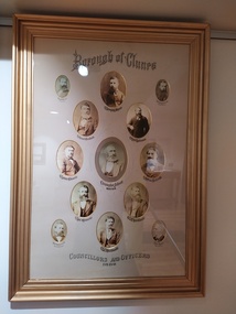
Photograph, W. J. NORMAN, C 1880
IT IS ON PERMAMENT LOAN FROM HEPBURN SHIRE COUNCILLORS AND OFFICERS OF CLUNES BOROUGH COUNCIL 1880. PHOTOGRAPH ORIGINALLY HUNG IN THE CLUNES TOWN HALL DURING THEIR TERM OF OFFICE.COLLAGE OF COUNCILLORS AND OFFICERS OF CLUNES BOROUGH COUNCIL 1880.BOROUGH OF CLUNES HUGH NOLAN - INSPECTOR, JOSEPH E MEYERS, ROBT COLQUHOUN MD - HEALTH OFFICER, ERNEST EBERHARD, FREDK ROBINSON, JAMES EDWARDS, CHRISTOPHER JOBSON - MAYOR ANDREW NICHOLLS, INO EDWARDS, J F WEICKHARDT, J C WEICKHARDT, ARTHUR BARTSON, JOHN ROFE - RATE COLLECTOR.local history, photographs, councillors & officers -
 Kew Historical Society Inc
Plan, Melbourne and Metropolitan Board of Works, Borough of Kew : Detail Plan No.1562, 1905
The Melbourne and Metropolitan Board of Works (MMBW) plans were produced from the 1890s to the 1950s. They were crucial to the design and development of Melbourne's sewerage and drainage system. The plans, at a scale of 40 feet to 1 inch (1:480), provide a detailed historical record of Melbourne streetscapes and environmental features. Each plan covers one or two street blocks (roughly six streets), showing details of buildings, including garden layouts and ownership boundaries, and features such as laneways, drains, bridges, parks, municipal boundaries and other prominent landmarks as they existed at the time each plan was produced. (Source: State Library of Victoria). This plan forms part of a large group of MMBW plans and maps that was donated to the Society by the Mr Poulter, City Engineer of the City of Kew in 1989. Within this collection, thirty-five hand-coloured plans, backed with linen, are of statewide significance as they include annotations that provide details of construction materials used in buildings in the first decade of the 20th century as well as additional information about land ownership and usage. The copies in the Public Record Office Victoria and the State Library of Victoria are monochrome versions which do not denote building materials so that the maps in this collection are invaluable and unique tools for researchers and heritage consultants. A number of the plans are not held in the collection of the State Library of Victoria so they have the additional attribute of rarity.Original survey plan, issued by the MMBW to a contractor with responsibility for constructing sewers in the area identified on the plan within the Borough of Kew. The plan was at some stage hand-coloured, possibly by the contractor, but more likely by officers working in the Engineering Department of the Borough and later Town, then City of Kew. The hand-coloured sections of buildings on the plan were used to denote masonry or brick constructions (pink), weatherboard constructions (yellow), and public buildings (grey). MMBW detail plan No.1562, in contrast to No.1561 includes the names of a large number of houses: in Barkers Road: ‘Ashwick’, ‘Owasso’, ‘Anadiha’, ‘Eurobin’, ‘Carlsruhe’, ‘Arlington’ and ‘Altyre’. Unnamed but clearly represented on the plan is what was then known as the ‘Auburn Heights Recreation Club’, which at this stage included a Bowling Green, a Croquet Green and two Tennis Courts. On the plan, Brougham Place, as it was then known, is represented. It was later renamed Daniell Place. The aforementioned Arlington is now the junior campus of Preshil. melbourne and metropolitan board of works, detail plans, mmbw 1562, cartography