Showing 15834 items
matching docuents-maps-france
-
 Warrnambool and District Historical Society Inc.
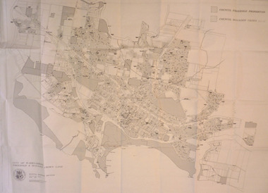
Map - City of Warrnambool Freehold and Managed Crown Land, City of Warrnambool Council, 14th April 1994
This map was drawn up by the City of Warrnambool Council staff to provide information on the land in Warrnambool that was owned or managed by the Council.This map is of considerable importance as it gives information in map form of the Warrnambool land that is owned (freehold) by the City of Warrnambool and the land that is managed Crown land. This is of interest to researchers and those seeking information on specific areas of land in Warrnambool.This map has digital mapping. The map has a white background with black and white mapping details of Warrnambool. It has the City of Warrnambool seal. Scale of map: 1:7500warrnambool city council, warrnambool -
 Bendigo Military Museum
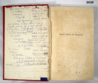
Book - BOOK, WW1, Hutchinson & Co (Publishers) Ltd, Field Guns in France, c.1922 - Forword dated 1.1922
Hard cardboard cover, red buckram with black print on spine, black outline on front. 255 pages, cut, plain, beige. Illustrated with black & red print folded maps attached at back of book. Inscriptions & markings throughout the book, too numerous to document. Found on front end paper & other pages. Attached to p92 are 2 newspaper clippings.Handwritten in faded blue ink: “Many notations on front end paper & numerous other pages”book, field guns, france -
 Moorabbin Air Museum
Manual (item) - CAC Commonwealth Aircraft Corporation Atar Reports To & From Engine Team in France, Reports and Letters From Engine Team in France; Reports and Letters To Engine Team in France
Commonwealth Aircraft Corporation -
 Warrnambool and District Historical Society Inc.
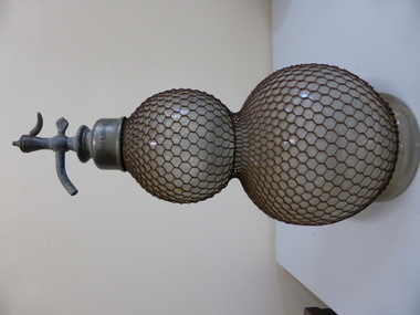
Functional object - Soda Syphon, Early 20th century
This soda syphon used for making carbonated drinks is a French bottle made about the beginning of the 20th century. This bottle is of considerable antiquarian interest but unfortunately has no known local significance. It may, however, be the one given to the Historical Society by Mr and Mrs S. Lindsay of Koroit Street, Warrnambool. It will be useful for display. This is a French soda syphon made of clear glass in a double bulbous shape. It is covered with wire mesh and has a pewter spout. The pewter is somewhat corroded and there is one small bend in the wire mesh. There is a small glass tube inside the bottle and a there is a crack in the glass on the top sphere. On pewter spout: ‘Veritable Seltzogene D. Fevre Paris’. Label pasted on: ‘80’ soda syphon, veritable seltzogene de fevre,, paris, warrnambool -
 Victorian Interpretive Projects Inc.
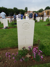
Photograph - Colour, Ann Gervasoni, Gravestone for F. Rawlings, Pheasant Wood Cemetery, Fromelles, 2014, 19/07/2015
The photographer, Ann Gervasoni, was in Frommelles for the reburial ceremony for 5 previously unidentified Australian soldiers. "AFTER almost 94 years, Ballarat soldier Private Frederick Rawlings, and a long-standing family mystery, can finally be laid to rest. Private Rawlings was one of 5533 Australian soldiers killed in the bloodiest conflict in Australian history, the World War I Battle of Fromelles, France. He was one of 250 men buried in a mass grave at Pheasant Wood after the battle of July 19 and 20 in 1916. In the past two years, a joint Australian and British project has aimed to positively identify the remains of those soldiers buried at the site. This week, the Federal Government announced Private Rawlings was one of 75 men who had been identified by name. Also on the list were Corporal Leslie Hart, born in Clunes, and Lance Corporal Allan Bennett, born in Ballarat, both of whom joined the army in Western Australia. All but one of the 75 soldiers have now been re-buried, with full military honours, at a specially constructed cemetery near the battle site. Private Rawlings' grand-niece, Maureen Holding, of Mannibadar, got a call to confirm the news on Tuesday night. 'It's just quite incredible after all these years and huge loss of life, they've actually identified him,' Mrs Holding said yesterday. Last year, Mrs Holding and her brother, Leo Rawlings, gave DNA samples to the Australian Army to help with the identification process. But until seeing a newspaper article more than 20 years ago, they did not know Private Rawlings or his younger brother, Corporal Sydney Rawlings, had even been in the war. On Anzac Day 1988, The Courier published a photo of Cpl Sydney Rawlings and excerpts from a letter from an army chaplain that informed Ballarat family members of Cpl Rawlings' death in Northern France in 1918. 'About two years later, my husband, Malcolm, found in a tin of rusty nails and shoe buckles belonging to my late dad, a set of war medals,' Mrs Holding said. They were inscribed with Sydney's Rawlings' name, and checks of family records and The Courier story confirmed the connection. In 1991, this newspaper published a list of soldiers who had memorial trees in Ballarat's Avenue of Honour. Next to Sydney's name was that of Frederick Rawlings.(http://www.thecourier.com.au/story/543125/remains-of-ballarat-soldier-killed-in-france-during-wwi-identified/, accessed 16/04/2014.)A number of colour digital images showing the grave of Frederick Rawlings of Ballarat in the Pheasant Wood Cemetery, Frommelles, France.world war one, fromelles, pheasant wood, frederick rawlings, allan bennett, leslie hart -
 Warrnambool and District Historical Society Inc.
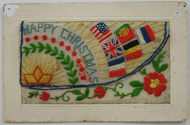
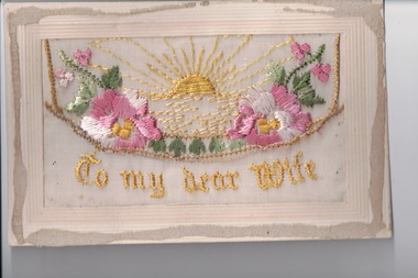
Document, Postcard embroidered, 1918
Embroidered cards such as this one were made by the French (usually women) for use as post cards for World War One soldiers to send home as greeting cards. The gift card with the embroidered card may not have been originally with it. The embroidered card has the date of October 1918, just one month before the official end of the war in November 1918. The name of the person who wrote ‘Somewhere in France’ on the back of the card is not listed but the handwriting appears to be similar to that on another card in our collection which is from R. Kerr from Kerr Street in Warrnambool. No information has been found on this soldier named Kerr. This embroidered card is of considerable significance as a very attractive memento of World War One and one, presumably, with local provenance. .1 The embroidered card is a World War One post card. The embroidery is on silk mounted on a white card. The embroidery is in yellow, blue, red, white and green colours and features a trail of flowers, a rising sun, six national flags, the words ‘Happy Christmas’ and other ornamentation. The embroidery is in two sections with a lift up section that could hold another card or note. The handwriting on the back has been written in pencil. The post card section has not been franked or posted. The card has marks at the edges where it has been attached to a surface with pins. The card is a little stained. .2 This is a small gift card with a coloured image of a girl with a basket of flowers.Embroidered card - ‘Happy Christmas’ ‘Somewhere in France 8/10/18’ Small gift card – ‘A Christmas Wish’ world war one and warrnambool, warrnambool historical society -
 Department of Energy, Environment and Climate Action
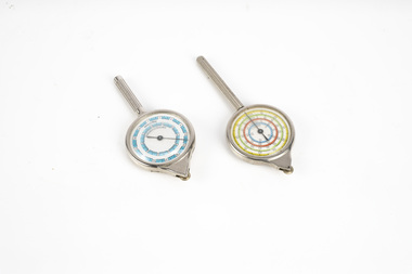
map measuring wheels
The map wheel is a simple, fast and accurate way to measure distances on maps, whether in straight lines or along curves. Hold the device from the tip and trace with the small wheel at the bottom along the line to be measured Measures distances in miles, kilometres or nautical miles depending on the scale on the side.Two metal map measuring wheel sMap scales on each side of wheelforests commission victoria (fcv), surveying, mapping -
 Ringwood RSL Sub-Branch
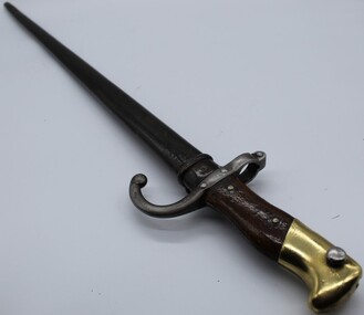
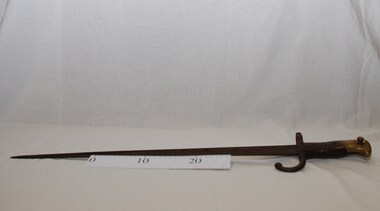
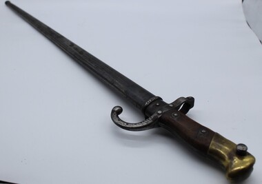
Edged weapon, French Gras bayonet, 1875
French gras sword bayonetMre d'armes de oulle mai 1875 -
4th/19th Prince of Wales's Light Horse Regiment Unit History Room
Framed Photograph, 4th Australian Light Horse - France, c 1915
Framed photo of Tpr Collins and Sgt Stark of 4th Australian Light Horse Regiment. Upper body shot, plain background. Members are in uniform. Sgt Stark is not wearing unit colour patch nor collar badges nor badges of rank. Perhaps photo was taken early in their service. Caption - 4th Australian Light Horse - France. 1087 Tpr James Collins, born 1890 Seymour Vic. B Squadron 7th Reinf . Enlisted 30th December 1914 RTA 11 May 1919 Wounded in the neck at Messines 7th June 1917. 1118 Sgt William Stark, born Casterton, Vic. B Squadron 7th Reinf Enlisted 4th January 1915 RTA 12th June 1919 WIA 7th June 1917 -
 Bacchus Marsh & District Historical Society
Map, Maddingley Township, Parish of Parwan, 1880s
This map is dated Sept. 6th 1856. However places in the township of Maddingley which did not appear until the late 1880s such as the Bacchus Marsh Railway Station and line are shown on this map in their correct locations. This suggests the map has been derived from an earlier map. An earlier date of 1843 with a surveyor's name preceding it can also be seen on the map. The map is important because it indicates the location and dimensions of early but now discontinued use of land such as the showgrounds and police paddock and a site reserved for the Church of England which was not ultimately used for a permanent church. A single page paper map showing land allotments, streets, rivers, creeks, park lands, the railway line and Bacchus Marsh railway station in the township of Maddingley. The map is pasted into a bound volume containing 76 maps or plans in total. Bottom of Map: Surveyor-General's Office, Melbourne, Sept 6th, 1856bacchus marsh victoria maps, maddingley victoria maps, land use, maddingley victoria history -
 Melbourne Tram Museum
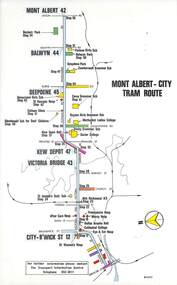
Map, Melbourne & Metropolitan Tramways Board (MMTB), Set of 15 tram route maps, 1977 to 1979
... Set of 15 tram route maps... Maps ...Series of 15 colour route maps for various tram lines or groups of tram lines for the MMTB. Some have the Transport Information Centre telephone printed on them, others have a label stuck on. Some are finished with a plastic laminate finish on either one or both sides. Show the major cross streets, parks, schools, other tram routes, major stop numbers and railway lines. Two copies of each held unless noted otherwise. .1 - Mont - Albert City - R11/77, shows routes 43. 47. 45. 44 .2 - Malvern, East Malvern, Carnegie and East Brighton Tram Routes (from St Kilda Junction) - R1/79 - shows routes 5, 3, 67, 66, 61, 62 and 64. .3 - Swanston St tram guide - R1/79 - lists all routes and route numbers that branch or cross Swanston St between Grattan St and St Kilda Junction. .4 - St Kilda Rd Tram Routes R12/77 - details South Melbourne Beach, route 1 and route 2 and St Kilda Beach routes 15, 16 and 55 otherwise shows were the various routes branch off St Kilda Road. Copy 1 has "P14909" in pencil in the bottom right hand corner. .5 - Kew - St Kilda Beach - R1/79 - Route 69. .6 - Footscray - Moonee Ponds - R3/81 - Route 82 .7 - Flinders St tram routes - R5/78 - North Balwyn, East Burwood, routes 48, 40, 41, Hartwell, 28, 74 and 75 .8 - William St tram routes - Route 55, 56 and 63 - South Melbourne Depot and Domain. copy 2 has "P14913" in bottom right hand corner. .9 - Toorak Camberwell and Glen Iris tram routes with Camberwell Junction and Malvern Town Hall, R1/79, routes 8, 7, 6, 72 and 73 shown. .10 - Swanston St tram routes - R12/77 - shows all the Swanston St routes, including East Coburg and Moreland. .11 - Bourke St tram routes - R4/77 - East Brunswick Blyth St and East Preston Tyler St and intermediate routes, routes 95, 96, 97, 90, 89 and 88. .12 - as for .11, dated 1/85, showing extension to La Trobe University - has Metropolitan Transit logo. Only 1 copy held. Also shows route 92 and 87. .13 - Batman Ave tram routes - R9/77 - Wattle Park, North Richmond and Prahran - routes 70, 71, 78 and 79. .14 - City route guide - R9/77 - showing all route numbers and destinations that passed through the CBD. .15 - Elizabeth St tram routes - R12/77 - Essendon Airport, West Maribyrnong, North Coburg lines, routes 50, 58, 60, 54, 57, 52. 49, 59, 18, 20 and 19. Copy 1 has "P14905" in pencil in bottom left hand corner.trams, tramways, maps, route guide, route numbers, routes, mont albert, route 43, route 47, route 45, route 44, route 42, malvern burke rd, east preston, carnegie, east brighton, south caulfield, route 5, route 3, route 67, route 62, route 64, route 66, glenhuntly tram depot, swanston st, st kilda rd, south melbourne beach, st kilda beach, route 1, route 2, route 15, route 16, route 55, kew- cotham road, route 69, route 79, route 82, footscray, moonee ponds, flinders st, north balwyn, kew, east burwood, burwood, hartwell, richmond, route 48, route 40, route 41, route 28, route 74, route 75, route 56, route 63, william st, west coburg, toorak, camberwell, glen iris, malvern town hall, route 72, route 73, route 7, route 8, bourke st, route 6, route 95, route 96, route 97, route 90, route 89, route 89, east preston, east brunswick, la trobe university, clifton hill, route 92, route 87, route 70, route 71, route 78, route 79, north richmond, prahran, wattle park, essendon airport, west maribyrnong, north coburg, route 50, route 58, route 60, route 54, route 57, route 52, route 49, route 59, route 18, route 20, route 19, batman ave -
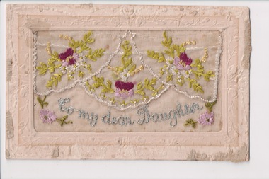 Wangaratta RSL Sub Branch
Postcard - Embroidered Postcard, c. 1916
Postcard from WWI soldier William West (1268) of the 29 Infantry Battalion, 5th Pioneers Battalion while posted in France to his family at home.Embroidered silk postcards were first made in 1900 for the Paris Exposition. The popularity of silk postcards peaked during the First World War 1914 - 1918.They were mostly embroidered by French women in their homes and then sent to the factories for cutting and mounting on cards. Many of the cards were illustrated with patriotic symbols, flags, slogans, or sentimental texts. During the First World War, many Allied officers and soldiers based in France sent silk embroidered postcards to their loved ones back homeWhite rectangular postcard with embroidered pink, purple flowers green foliate decoration on front. Handwritten message on the back.Front: "To my dear Daughter" (embroidered) Back: "France / 23/1/1916 / To Dear Little Enid / From Daddy Dear / Best Love / xxxxxxxxxxxxxxxx"wwi, postcard, embroidered postcard -
 Peterborough History Group
Map - Map of Peterborough House 1921, 1921
This hand drawn map of the buildings and out buildings was done for insurance purposes. It indicates which buildings are covered and which are uninsured. Significant as it shows a plan of the hotel as it was in 1921. Each building is labelled by its purpose, which provides an interesting insight into holidays of the time. For example, 'sleep outs' and external bathrooms. A4 photocopy of a hand drawn map of the buildings and out buildings comprising Peterborough House. Hand drawn map -
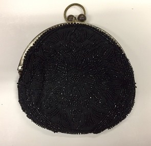 Kew Historical Society Inc
Accessory, Beaded Black Silk Evening Purse, 1900s
The Kew Historical Society's Fashion & Design collection includes a small and representative collection of reticules, purses and handbags, purchased, inherited or collected by members of the Society. These items date from the Nineteenth and Twentieth centuries, and conform to fashions and styles popular during the period of their use. Some of the items are handmade, while others are mass-produced commercial products. Hand-beaded evening purse, with silver frame and finger ring. While the note accompanying the item states that it was made and used in the 1880s, the label 'Made in France' would indicate that it was probably made in the first decade of the twentieth century.Label: "Made in France / Hand-made". A note which accompanies the item states: "Hand beaded evening purse, 1880s. Frequently used when formal dinner dances were held in the Kew mansions." [Editor - See correct date in Physical description]fashion accessories, clothing accessories, women's clothing -- accessories, bags -- handbags, bags -- purses -
 Beechworth RSL Sub-Branch
Scabbard, French Scabbard, Circa 1875
Acquired by Clyde Marshall During his tour of duty with RAAF 2 Squadron 1967/68Obtained whilst Clyde was on duty with 2 SquadronScabbard metal French Circa 1875 embossed numbers on bayonet stock 97314 preceding the numbers is indecipherable mark that could be a maker markscabbard, metal scabbard, french scabbard -
 Wangaratta RSL Sub Branch
Postcard - Embroidered Postcard, c. 1917
Postcard from WWI soldier William West (1268) of the 29 Infantry Battalion, 5th Pioneers Battalion while posted in France to his family at home.Embroidered silk postcards were first made in 1900 for the Paris Exposition. The popularity of silk postcards peaked during the First World War 1914 - 1918.They were mostly embroidered by French women in their homes and then sent to the factories for cutting and mounting on cards. Many of the cards were illustrated with patriotic symbols, flags, slogans, or sentimental texts. During the First World War, many Allied officers and soldiers based in France sent silk embroidered postcards to their loved ones back homeWhite rectangular postcard with embroidered pink flower, green foliate and yellow rising sun decoration on front. Handwritten message on the back.Front: "To my dear Wife" (embroidered) Back: "Best love from your loving / H[usband] ??????? France ???? 1919 / ???? presents / money on ??? to not / so you keep ?????"wwi, postcard, embroidered postcard -
 Montmorency/Eltham RSL Sub Branch
Weapon - Bayonet, French, Gras, 1874 French Bayonet, Estimated date 1874-1886
French Model 1874 Gras Sword Bayonet, less scabbard, made for the French Bolt Action Rifle Fusil Gras M80 1874.france, 1874, bayonet, french gras bayonet, gras bayonet, gras sword, bolt action rifle -
 RSL Victoria - Anzac House Reference Library and Memorabilia Collection
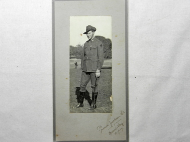
Photograph of John William Alexander Jackson, July 1917
William Jackson (588 - 17th Battalion, B Company) embarked from Sydney onboard HMAT Themistocles on 12th May 1915. Awarded the Victoria Cross for conspicuous bravery in France in June 1916. Died in 1959, aged 61 years. Victoria Cross 'For most conspicuous bravery. On the return from a successful raid, several members of the raiding party were seriously wounded in "No Man's Land" by shell fire. Private Jackson got back safely and, after handing over a prisoner whom he had brought in, immediately went out again under very heavy shell fire and assisted in bringing in a wounded man. He then went out again, and with a sergeant was bringing another wounded man when his arm was blown off by a shell and the sergeant was rendered unconscious. He then returned to our trenches, obtained assistance, and went out again to look for his two wounded comrades. He set a splendid example of pluck and determination. His work has always been marked by the greatest coolness and bravery.' Source: 'Commonwealth Gazette' No. 184 Date: 14 December 1916 Photograph of Australia's youngest Victoria Cross winner.WW1 photograph of William Jackson (17th Battalion, B Company) taken on "France's Day 13-7-17".france, ww1, victoria cross, william jackson, 17 battalion -
 Bendigo Military Museum
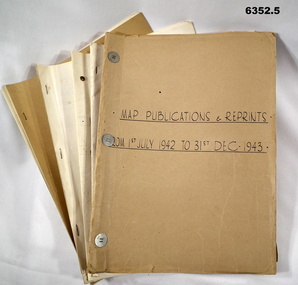
Administrative record - LHQ Cartographic Coy - Map Printing and Reprints 1 July 1942- 31 Dec 1947, LHQ Cartographic Coy, 1942-1947
The Land Headquarters Cartographic Company relocated to Fortuna Villa, Bendigo in 1942. With printing presses acquired from a number of civilian organizations it printed the maps needed for the Australian WW11 war effort. These records detail which maps were printed during those years. Photographs of the printing machines and the printers who used them are shown in Victorian Collections item 6148 LHQ Carto Coy Souvenir Booklet. 6352.1 Map Publishing and Reprinting Reports 1 July 1942 - 31 Dec 1943 6352.2 Map Publishing and Reprinting Reports 1 July 1943 - 31 Dec 1944 6352.3 Map Publishing and Reprinting Reports 1 July 1944 - 31 Dec 1945 6352.4 Map Publishing and Reprinting Reports 1 July 1945 - 31 Dec 1946 6352.5 Map Publishing and Reprinting Reports 1 July 1946 - 31 Dec 1947Five Manilla Folders containing Map Printing ReportsHand written on the Folder covers: 6352.1 Map Publishing and Reprinting Reports 1 July 1942 - 31 Dec 1943 6352.2 Map Publishing and Reprinting Reports 1 July 1943 - 31 Dec 1944 6352.3 Map Publishing and Reprinting Reports 1 July 1944 - 31 Dec 1945 6352.4 Map Publishing and Reprinting Reports 1 July 1945 - 31 Dec 1946 6352.5 Map Publishing and Reprinting Reports 1 July 1946 - 31 Dec 1947royal australian survey corps, rasvy, fortuna, army survey regiment, army svy regt, asr -
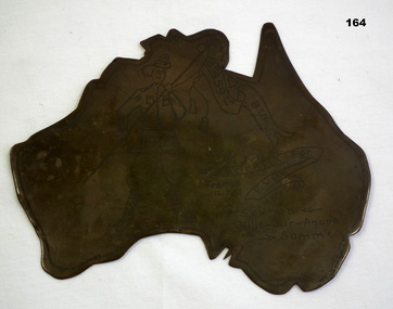 Bendigo Military Museum
Memorabilia - TRENCH ART, WW1
Regarding P Sexton. There is a Patrick Sexton listed in the 59th Batt roll No 3243a. The trench art was in the collection of James Worland Mills No 3441 59th Batt AIF. Refer 169P, 166.3, 167.6. Map of Australia made from spent munitions brass; engraved with picture of soldier holding a banner.'59th Btn.' - written on Union Jack in corner of banner. 'Australia for Ever' written on 2nd banner. 'CD' written between soldier's feet. Other inscriptions: 'France 12.7.18', and 'P. Sexton Ville-Sur Ancre Somme.arms-ammunition, trench art -
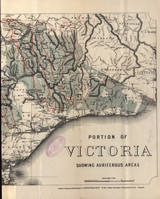 Federation University Historical Collection
Map - Map and Information, Department of Mines: Map and Suggestions to Prospectors, 1891
The map outlines the auriferous (gold bearing) areas in Victoria. The information for prospectors was prepared by the Department of Mines in 1894Document: 4 page type written Map: Portion of Victoria divided into Counties of 1891. Auriferous areas with red.Reference section on mapgold, auriferous areas, department of mines, victoria, map of victoria, prospectors, commissioner of crown lands, hon a mclean, alexander black, surveyor general, a mclean -
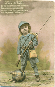 Warrnambool and District Historical Society Inc.
Postcard - Child Soldier, 1914-1918
Daisy Vickers collection: Item 5 of 27Historical Information This is number 24 of 27 items in the Daisy Vickers collection of World War One memorabilia. These items were sent or given to Daisy Ogier (nee Vickers) during World War One by Corporal Arthur Anderson who enlisted from Warrnambool in 1915 at the age of 21. He served in Egypt and France and returned to Australia in 1919. Daisy Ogier (1907-1987) was a student and then a teacher at Warrnambool Technical School with her early teaching years there from 1925 to 1936 and in 1949. She became the head mistress from 1950 to 1963 and in 1968. She officially retired in 1976. Daisy Vickers was one of the best loved and dedicated teachers that the school ever had. She married the Reverend Fred Ogier and continued her association with the school after her husband's death.This card is interesting because of its association with World War One and two local people Daisy Vickers and Arthur AndersonThis postcard has an image of a child soldier holding a gun with a helmet at his foot, There is printing in French on the front and on the back space for correspondence and an address.Graine de Poilu Qu'ils y viennente les boches Nous sommes un peu la! An secteur des gavroches Nul ne passe Halte - la! ! daisy vickers, arthur anderson, world war one, world war one postcard -
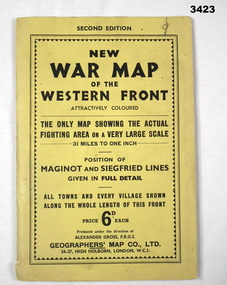 Bendigo Military Museum
Map - WAR MAP WESTERN FRONT, Geographer's Map Co Ltd, c.WWII
Folded map fixed into yellow cardboard folder with black printing. Map covers battle areas late in WWII of Maginot Line & Siegfried Line from Metz, France to Karlsruhe, Germany.On cover in black print: “Second Edition. New War Map of the Western Front”map, seigfreid, maginot -
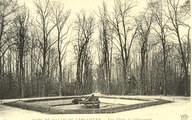 Federation University Historical Collection
Postcard - Postcard - black and white, Parc Du Palais De Versailles, c1914
This postcard was most probably sent to Australia by an Australian soldier during World War One. Black and white postcard showing Versailles, France. Parc du Palais De Versailles - Les Alles de l'Orangerieworld war one, versailles, france, chatham-holmes collection -
 Ringwood RSL Sub-Branch
Edged weapon, 1875
French Gras sword bayonet with metal scabbardArmoury mark Mre d ormes de oullemayo 1875. No 418 -
 Bendigo Military Museum
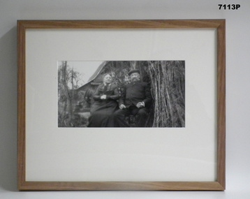
Photograph - PHOTOGRAPH - FRAMED WW1, Wayne Eels, C.2008/2009
The Grinton Collection. A French Couple at Home. Refer Cat No. 1280 for Jack Grintons service details.Photograph framed. Photograph - black and white photograph on paper, depicting two civilians (French couple) sitting surrounded by vegetation. Cottage/building in the background. Frame - timber, light varnish finish, Perspex front, cardboard backing."Group 2: Burden of War". "J. French couple".framed accessories, camera on the somme, 38th bn, grinton, ww1, civilians -
 Anglesea and District Historical Society
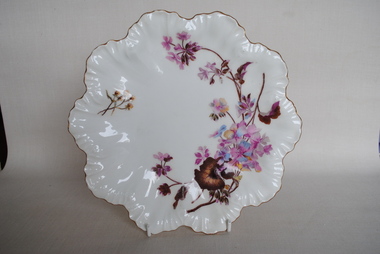
Plate, A. Lanternier
Limoges plate - white porcelain with mauve floral asymmetrical decoration. Scallopshaped border with gold edge decoration. Some scratch marks - evidence of use.LIMOGES / A. LANTERNIER / FRANCEa lanternier, limoge -
Clunes Museum
Textile - SILK HANDKERCHIEF
RED SILK EMBROIDERED HANDKERCHIEF, WITH RED SCALLOPED EDGE.SOUVENIR FROM FRANCElocal history, costume accessories, handkerchief, w.w.1 memorabilia, silk handkerchief -
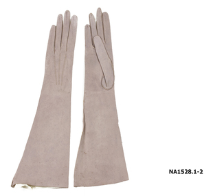 Whitehorse Historical Society Inc.
Clothing - Gloves
Fine suede pink/mushroom ladies gloves. Elbow lengthMade in France Washablecostume accessories, glove accessories -
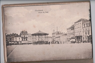 Lara RSL Sub Branch
Postcards, France
John Lachlan McIntyre was born at Beeac, Victoria in December 1890. He enlisted in the 1st AIF in July 1915. John fought on the Western Front, taking part in the battles of Fromelles and the 2nd Battle of the Somme. He was severely wounded at Fromelles and spent 12 months in hospital in England before returning to the front. John returned home in 1919 and was granted a soldier settlement block in Lara in 1937. He was a founding member of Lara RSL and is its longest serving member. John died in 1990. This letter was written by John and sent to his mother in 1918 on his journey through Belgium. The McIntyre family were early pioneers in the Lara district, and the brothers were founding members of the Lara RSL. This letter represents a significant link to the history of the town and sub-branch.A brown envelope addressed to Miss J McIntyre. Within the envelope is a pack of 12 illustrated souvenir post cards. Envelope: O.A.S. Tower of London. Miss J McIntyre. Elcho Lara lake, Australia, Victoria. Rear of postcard pack: London December 27th 18 Dear Mother, I arrived here yesterday. Spent Xmas day travelling across France. The trip took the best part of four days. We are up near Belgium. Had to go into Belgium to get a train. Will write when I get settled. Hoping you are all well. With best wishes for a happy new year. Jack. Edition Martinetty Charleroi Front of pack: J. L. McIntyre Xmas 1918 Souvenir de Charleroi-Belgium 12 cartes postales 12 En Photochrommother, letter, postcard, first world war, wwi, world war one, belgium, lara