Showing 266 items
matching early residences
-
 Ringwood and District Historical Society
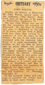
Newspaper - Clipping, Death of John Wilson, 21 September, 1938
Obituary - Ringwood Mail 29/9/1938The late John Wilson was one of the few remaining old pioneers of Ringwood ... passed away at his residence, "The Mines", Ringwood East (Wilson Street) at the age of 80 years. He was, in the early years, associated with the antimony mine ... highly respected and esteemed throughout the district. -
 Bendigo Historical Society Inc.
Document - SPECIMEN COTTAGE COLLECTION: VARIOUS DOCUMENTS
Various documents in plastic folders. The topics are: 4030.1 – 4300.25 Various documents in plastic folders. Various documents in plastic folders. The topics are: 4030.1 Photocopy of an article titled Saunders' Victoria House. Also a map of the Saunders residence in High Street. 4030.2. Article titled What I saw in gaol July 1889 (written by Gilbert Rule.. 4030.3. Eleven pages essay: H. M. Prison Bendigo after a short history of the prison there are details of several criminal cases. Also brochure H.M. Prison Bendigo 1861-2006, Official decommissioning ceremony 5 January 2006. 4030.4. The Temple Builders, talk by Alex H. Stone 10th May, 1998. 4030.5. The German contribution to early Bendigo by Frank Cusack. 4030.6. Children's games played during and prior to the great depression, Interviews conducted by James Lerk. People interviewed are: Stella Banfield, Mary Pickles, Geoff Newman, Vel Newman, Joan O'Donahue, Peg Schlotterlein, James Gallagher, Jack Larkin, Ken Maes. 4030.7. Email from Hans Tracksdorf to Andy Walker and Ana Hilson updating on the Charlton Building at 60-62 Mundy Street, June 2015, several coloured photos attached. 4030.8. Notes on the family of Elizabeth Ann Butler. 4030.9. The Amy Castles story, a narrative on the life of the singer Amy Castles. Also a booklet ''I lived for the art'' The story of Amy Castles concert program. 4030.10. Harcourt Valley Heritage & Tourist Centre ''Granite houses of Faraday and Harcourt'' by George Milford, March 2010. 4030.11. The story of Knipe's castle and the man who built it, John Hanlon Knipe. A paper presented by Mrs. Edith Lunn 2nd April, 1987. Also some photographs of graves and various documents. 4030.12. Report: Victorian Heritage database place details 15/07/2014 former Kahland winery and cellars. Also two coloured photographs from Tony Robinson' s walk around Bendigo, Kahland street - Lynden house built 1873 wine cellar. 4030.13. several letters from James and Dinah Jeal to their parents detailing their travels on the goldfields dates from 1855 to 1865. 4030.14. Photocopy of a six pages hand written letter to a Walter Edis (?. in England from a J. Wharton (?. from Woodstock on Loddon, detailing his boat trip to Melbourne and the train trip to Marong where he is working. Letter dated July 9th, 1923. 4030.15. The history of T.C. Watts & Son, real estate agents in Bendigo by Edith Lunn. September 30th, 2000. 4030.16. Medals created by Messrs Joseph and Co. Pall Mall, Sandhurst and Melbourne with special reference to ''Champion Medals'' created for the Bendigo Rifles and other Victorian forces. 1858 to 1885. Compiled by Angus Pearson December 2012. 4030.17. Talk by Jim Evans at September 202 meeting of the Bendigo Historical Society. The Inimitable Charles Thatcher, colonial minstrel. 4030.18. Six pages typewritten document titled: C.R. Thatcher, the local songster. Date and author unknown. 4030.19. Music sheet. The Chinaman. Thatcher's colonial songs as written and sung by Charles Robert Thatcher during the goldrushes in the Shamrock hotel, Bendigo. 4030.20. Heidi Teague young historian award two pages detailing the criteria for the award, a newspaper obituary for Heidi Teague and a twenty five pages transcribe interview of Heidi Teague, Heidi was interviewed by Ines Tyson and transcribed by Carol Woolman in 2009. 4030.21. Photograph of Richard Bertram Taylor in military uniform, Richard was killed in action in WWI. Also a brief family history 4030.22. Six pages typewritten letter from John Stuart, Assistant Surgeon Royal Navy to chief Secretary The Honourable C. Haines dated Sandhurst 27th May, 1857 regarding Chinese protectorate. 4030.23. Eight pages biography with photos of Sister Clara Stewart. 4030.24. Two pages biography on John Boyd Watson (and sons. by Rob Upson 4030.25. History of Alick Wilkinson & other grocers 1930 onwards. Compiled by Vernon and Garran Wilkinson. -
 Eltham District Historical Society Inc
Slide - Photograph, Nillumbik Cemetery, 35 Main Street, Diamond Creek, 27 May 1990
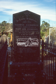
George Stebbing arrived from England in 1857 and settled at Eltham after a short period at Kangaroo Ground. His occupation is often listed as a farmer but he built a number of important buildings between the late 1860’s and the 1880’s. Those remaining include Shillinglaw Cottage, St. Margaret’s Church, Uniting church (formerly Methodist Church) and House at 84 Pitt Street, Eltham. From 1871 to 1875 he was a member of the Eltham Shire Council. Evelyn Observer and Bourke East Record (Vic. : 1902 - 1917), Friday 12 March 1909, page 2 ELTHAM. (FROM OUR OWN CORRESPONDENT.) One of the oldest inhabitants of Eltham passed away during the early hours of Saturday last in the person of Mrs Mary Ann Stebbings. Her residence here covered a period of some-what over 50 years. She had been a widow for some time, her husband, the late Mr. Geo. Stebbings, having pre-deceased her some fourteen or fifteen years. During the later years of her life, she had resided with her niece, Mrs. Wm. Williams. She lived a very retired life and is said to have owned a considerable amount of property, local and suburban, at the time of her death, at the age of 82 years. She was interred at Diamond Creek on Sunday, 7th inst. Local Cemetery Excursion Sunday 27 May 1990 departed Eltham Shire Office at 9.30am and finish mid afternoon. Visits to Eltham , Kangaroo Ground, Queenstown (Smiths Gully), Nillumbik (Diamond Creek), St Katherines (St Helena) Hurst family graves at Hurstbridge and a little known early cemetery at Greensborough. Attended by 20 members. In each case we were introduced to the cemetery with a brief talk. At Eltham, Frank Burgoyne gave us the benefit of his knowledge as a member of the cemetery trust and at Kangaroo Ground, Bruce Ness spoke in a similar capacity. The lunch stop was at Hurstbridge where we visited the Hurst family graves. The President of Nillumbik Historical Society, Jock Ryan, joined us at the Nillumbik (Diamond Creek) cemetery. He travelled on to St Katherines, St Helena, where he talked on the history of the church and cemetery. 35mm colour positive transparency (1 of 23) Mount - Agfachrome Agfa CS System black 8 dotsshire of eltham historical society, cemetery excursion, graves, activities, cemeteries, george stebbing, george stebbings, mary ann stebbing, mary ann stebbings, nillumbik cemetery -
 Eltham District Historical Society Inc
Slide - Photograph, Nillumbik Cemetery, 35 Main Street, Diamond Creek, 27 May 1990
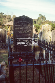
George Stebbing arrived from England in 1857 and settled at Eltham after a short period at Kangaroo Ground. His occupation is often listed as a farmer but he built a number of important buildings between the late 1860’s and the 1880’s. Those remaining include Shillinglaw Cottage, St. Margaret’s Church, Uniting church (formerly Methodist Church) and House at 84 Pitt Street, Eltham. From 1871 to 1875 he was a member of the Eltham Shire Council. Evelyn Observer and Bourke East Record (Vic. : 1902 - 1917), Friday 12 March 1909, page 2 ELTHAM. (FROM OUR OWN CORRESPONDENT.) One of the oldest inhabitants of Eltham passed away during the early hours of Saturday last in the person of Mrs Mary Ann Stebbings. Her residence here covered a period of some-what over 50 years. She had been a widow for some time, her husband, the late Mr. Geo. Stebbings, having pre-deceased her some fourteen or fifteen years. During the later years of her life, she had resided with her niece, Mrs. Wm. Williams. She lived a very retired life and is said to have owned a considerable amount of property, local and suburban, at the time of her death, at the age of 82 years. She was interred at Diamond Creek on Sunday, 7th inst. Local Cemetery Excursion Sunday 27 May 1990 departed Eltham Shire Office at 9.30am and finish mid afternoon. Visits to Eltham , Kangaroo Ground, Queenstown (Smiths Gully), Nillumbik (Diamond Creek), St Katherines (St Helena) Hurst family graves at Hurstbridge and a little known early cemetery at Greensborough. Attended by 20 members. In each case we were introduced to the cemetery with a brief talk. At Eltham, Frank Burgoyne gave us the benefit of his knowledge as a member of the cemetery trust and at Kangaroo Ground, Bruce Ness spoke in a similar capacity. The lunch stop was at Hurstbridge where we visited the Hurst family graves. The President of Nillumbik Historical Society, Jock Ryan, joined us at the Nillumbik (Diamond Creek) cemetery. He travelled on to St Katherines, St Helena, where he talked on the history of the church and cemetery. 35mm colour positive transparency (1 of 23) Mount - Agfachrome Agfa CS System black 8 dotsshire of eltham historical society, cemetery excursion, graves, activities, cemeteries, george stebbing, george stebbings, mary ann stebbing, mary ann stebbings, nillumbik cemetery -
 Glenelg Shire Council Cultural Collection
Painting, a) Johnston & Co. Hamilton b) Johnstone O'Shannessy, Melbourne, Burswood, late 1800s
From Victorian Heritage: The single storey mansion house with enclosed glass verandah, Burswood was built in 1853 on a site overlooking the Portland Bay for English born pioneer colonist Edward Henty. John Barrow of Adelaide was the architect for this exceptional Australian regency style residence which he designed as a central block of fine axed basalt ashlar and slate roof (now replaced) with flanking brick wings forming an enclosed rear courtyard. Burswood is the most important early mansion house in western Victoria, being an exceptional Australian regency design by distinguished colonial architect James Barrow. Edward Henty, a member of one of Australia's most remarkable colonial families and the founder of Portland, established the first permanent settlement in Victoria on 19th November 1834, and Burswood is testimony to his success as an early colonist. Henty lived in his mansion for 17 years in a semi-regal state. Burswood has been little altered since completion in 1853. A glasshouse conservatory to the side of the present enclosed verandah was demolished prior to 1895 and the slate roof replaced with iron. Johnstone, O’Shannessy & Co was a leading photographic studio located in Melbourne, Victoria, Australia. It was active from 1865 to 1905. Henry James Johnstone was also an artist and studied at Louis Buvelot's school and with Thomas Clark.Painting of a sandstone coloured building. A grand house with a driveway and well-kept gardens to the front. There is a horse and cart with a man standing to the side of it. There is a female figure exiting the building and another female and a man further along the driveway with a dog. The building has a glass conservatory attached to the side. The sky is blue with several fluffy clouds.Bottom right: Johnstone O'Shannessy & Co Melbourne (in white paint)homestead, henty, historic buildings, colonial, burswood house -
 Sunbury Family History and Heritage Society Inc.
Photograph, Former Engineer's Cottage
The building was the residence of the engineer who was responsible of managing the early electric supply that was installed in Sunbury in 1909. The town's power supply put an end to gas lighting that had been used and homes had the benefit of having electricity connected to their homes. In 1926 the State Electricity Commission took over supplying electrical power to Sunbury. The cottage is now a private home and the power house building has been demolished. he complex occupied land on the corner of Jackson and Shields Street.At the time the electric supply was installed in Sunbury in 1909, few small country towns had electric power connected.A non-digital scanned coloured photograph with a narrow white border of a small double fronted wooden cottage with a corrugated iron roof with trees growing behind the building.electricity, engineer's corrage, jackson street, shields street, power supplies -
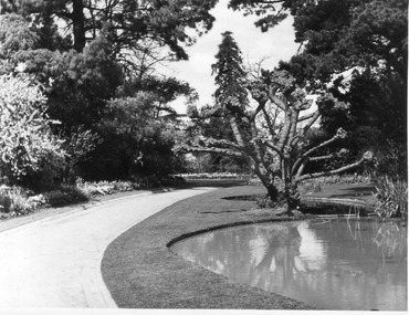 University of Melbourne, Burnley Campus Archives
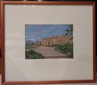
Photograph - Black and white print, Driveway to Principal's Residence, 1947
Appears as an illustration in, "Green Grows Our Garden, A.P. Winzenried p 77. Removed, after the Principals Residence was taken down, in 1980. "This narrow path replaced an earlier avenue which led up to the Curator's house (later Principal's Residence) . The avenue was lined with pine trees some of which survive." T.H. Kneen.Black and white photograph. Lily Ponds to the right of the driveway.On reverse, "Late Sept. 1947. Drive to house with pond & willows (pruned). Drive curves to left."lily ponds, driveway, green grows our garden, a.p. winzenried, principal's residence, luffmann ponds, pine trees -
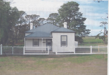
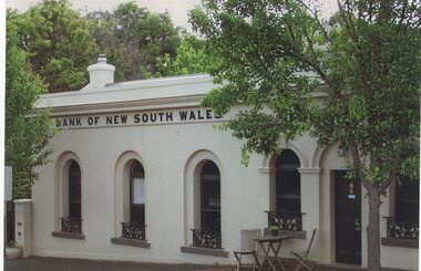 Linton and District Historical Society Inc
Photograph, Traquair House, Sussex Street, Linton, 2014
The original bank and residence were built in 1862, and the building was extended in 1873-74. The three windows on the left of the photograph are in the original building, and the windows and door on the right of the photograph are in the extension. The brick building was cement-rendered at an unknown later date. In 1904 the Bank of New South Wales built a new banking chamber & residence on the west side of Sussex Street next to the Post Office, after which the earlier building became a private residence. It was lived in for many years by members of the Lewers family (Samuel Lewers had been first manager of the Bank of NSW in Linton) and was purchased in the early 1960s by Stella Surman (née Todd). More recently it has been used as an antique shop and tea rooms, and it is currently a private residence. This photograph was taken in 2014 by Gary Hunt.One of three colour photographs printed on a single sheet of photographic paper. The photograph shows Linton's first Bank of New South Wales building, now called Traquair House.traquair house, 90 sussex street linton, buildings, houses, bank of new south wales -
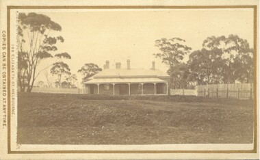 Bacchus Marsh & District Historical Society
Photograph, The Bungalow, house built for Doctor Rae, Bacchus Marsh 1883
This image is one of a series of photographs taken by Melbourne based photographers Stevenson and McNicoll who visited Bacchus Marsh and its nearby districts between September and November 1883. The house was built for Dr. Rae in 1880 following his retirement from his medical practice due to ill health. He lived there until his death. Dr. Vance then occupied it for a short time. It was bought by the sisters of St. Joseph in 1890 and formed the nucleus of St. Joseph’s Convent. It was demolished in the early years of the twentieth century, when a new two-storey brick convent was built.Small sepia 'carte de viste' style unframed photograph on card with gold border framing photograph. Housed in the Jeremeas Family Album which contains photographs of Bacchus Marsh and District in 1883 by the photographers Stevenson and McNicoll.The photo is of a large single-storey brick house with a return verandah supported by simple columns. Five chimneys can be seen. The house sits on a large block of land in a bush setting, with a hedge separating the house and garden. A picket fence runs across the block, with a paling fence along the northern side.Printed On the front: Stevenson & McNicoll. Photo. 108 Elizabeth St. Melbourne. COPIES CAN BE OBTAINED AT ANY TIME. On the back: LIGHT & TRUTH inscribed on a banner surmounted by a representation of the rising sun. Copies of this Portrait can be had at any time by sending the Name and Post Office Money Order or Stamps for the amount of order to STEVENSON & McNICOLL LATE BENSON & STEVENSON, Photographers. 108 Elizabeth Street, MELBOURNE. stevenson and mcnicoll 1883 photographs of bacchus marsh and district, doctors, houses bacchus marsh, convents, religious residences -
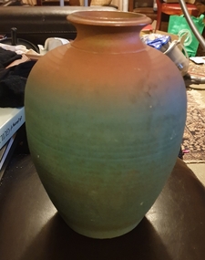 Ballarat Heritage Services
Photograph, Vessel by Mark Reid, 1989
Mark Reid began potting in the early 1980s, working for a time in North Queensland. In 1985, he and his wife Robyn set up the Torvil Pottery at Buninyong near Ballarat in Victoria. In 1991, they relocated to a 10 acre property in nearby Magpie and set up the Ballarat Clayfire Gallery with a working studio, gallery and residence. In 2005, he Clayfire Gallery was located to Daylesford. Mark Reid signs his work with an incised 'Mark Reid' or 'MR'.mark reid, australia studio pottery, ceramics, torvil pottery, buninyong, magpie, clayfire gallery, ballarat clayfire gallery, daylesford -
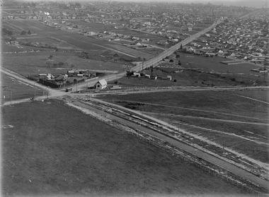 Melbourne Tram Museum
Photograph - Digital Image, Kevin O'Reilly, "Kew Burke Rd' looking at the East Kew Tram terminus, c1925
Image from CD (Compact Diskette for use in computers) - see Reg Item 135. Image titled "Kew Burke Rd' on CD, of looking at the East Kew Tram terminus with the city skyline in the background, c1925. Photo published in the Bellcord No. 16, Oct. 2012. From the article with the photograph; The terminus was located at the intersection of High St, Burke, Kilby and Doncaster Roads. We are at the outer edges of Melbourne’s suburbia at the time, unlike the current tram terminus of today. Burke Road, north of Doncaster Road is clearly under construction in preparation for the new river crossing. The vacant block of land in the foreground will remain so for another ten years or so. In 1960 the new Dickens Supermarket was built on this site and the intersection became known locally as Dickens Corner. The narrow track on the left hand side of the photo is Doncaster Road. The tram at the terminus is a straight-sill single trucker of one of the G, K, Q or R classes. It is finished in the late MMTB chocolate and cream livery. A cable grip car body has been placed as a tram shelter at the terminus. The church was subsequently relocated to Francis Street Yarraville where it still stands today as a private residence. Behind the large hedge on the south side of High Street is Smith’s Dairy. Part of this land would be sold to the MMTB for a planned new tram depot Behind the large hedge on the south side of High Street is Smith’s Dairy. Part of this land would be sold to the MMTB for a planned new tram depot but by the early 1960s it was transferred to the Education Department for construction of the Kew High School. The last portion of the dairy closed in the 1970s.trams, tramways, kew, burke rd, east kew, doncaster rd -
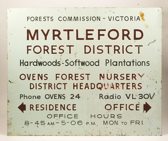 Forests Commission Retired Personnel Association (FCRPA)
Myrtleford Forest District office sign, Included Oven's nursery
This metal and enamel sign is believed to have hung outside the Myrtleford Forest District Office. It includes directions to the Ovens Nursery, Office and Residence Phone numbers, radio call signs (VL30V) and office hours are included It also makes reference to hardwood and softwoods In 1956, the new Chairman of the Forests Commission, Alf Lawrence, introduced a major restructure of the organisation to create 56 Forest Districts. The process included amalgamating the plantations and hardwood divisions, which had been separate and rival entities up to that time. Things remained largely unchanged for the next three decades until the early 1980s.Myrtleford Forest District office signforest signs, forests commission victoria (fcv) -
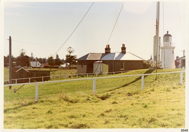
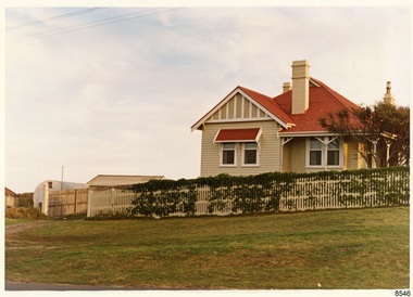 Flagstaff Hill Maritime Museum and Village
Photograph - Historical, Flagstaff Hill, Harbourmaster’s Quarters, 1970s
The photograph shows a cottage, Harbourmaster’s quarters that still stands on the east of the Lady Bay Lighthouse and Historic Precinct at Flagstaff Hill in Warrnambool. The name was changed to the Lighthouse Lodge, and today guests can stay at the property. This photograph, a print, is one of a set of five that show the site of Flagstaff Hill. It is presumed to have been taken by John Lindsay, Founding Director of Flagstaff Hill Maritime Museum and Village. One of the photographs in the set has the pencil inscription "Photo J Lindsay". It was taken in the early 1970s during the initial stages of the development of Flagstaff Hill as a Museum and Maritime Village. The photographs belonged to the donor's grandparents, who lived in the Warrnambool district of Allansford/Naringal. The photograph is a record of the site and surrounds of Flagstaff Hill Maritime Museum and Village before its development and opening in 1975. It shows the cottage on the east of the Lighthouse Complex,. The building is now known as Lighthouse Lodge. The photograph is significant for recording the location and condition of the residence on the Hill.Coloured photograph, glassy print, one of a set of five. Photograph shows the cream timber cottage, Harbourmaster’s quarters to the east of the lighthouse complex at Flagstaff Hill, Warrnambool. On the left of the red roofed residence are iron buildings used, at the time, by the Lands Department. The photograph's paper has the printer's watermark on the back. The early 1970s photograph is presumed to have been by John Lindsay, Warrnambool.Label on the back: "WOODEN RESIDENCE TO THE EAST OF THE PROPERTY / The gun emplacements are immediately behind, and the iron huts to the left rear of the residence are used by the Lands Department who plan to vacate, for other premises."flagstaff hill, flagstaff hill maritime museum and village, warrnambool, maritime museum, maritime village, great ocean road, shipwreck coast, 1970s, photograph, flagstaff hill site, john lindsay, cannon emplacement, residence, wooden residence, timber residence, iron huts, lands department -
 Flagstaff Hill Maritime Museum and Village
Photograph - Historical, Flagstaff Hill, The Lighthouse keepers cottage, from the gun emplacements, looking towards the town centre, 1970s
The photograph shows the back of the Lighthouse Keeper's Quarters and the privy, Upper Lighthouse and Flagstaff, and the condition and placement of these buildings and the street. The note on the back points out the uniqueness of the double-sided toilet building, and the well at the back of the Quarters. This photograph, a print, is one of a set of five that show the site of Flagstaff Hill. It is presumed to have been taken by John Lindsay, Founding Director of Flagstaff Hill Maritime Museum and Village. One of the photographs in the set has the pencil inscription "Photo J Lindsay". It was taken in the early 1970s during the initial stages of the development of Flagstaff Hill as a Museum and Maritime Village. The photographs belonged to the donor's grandparents, who lived in the Warrnambool district of Allansford/Naringal. The photograph is a record of the site and surrounds of Flagstaff Hill Maritime Museum and Village before its development and opening in 1975. It shows the Heritage Listed Precinct; the Lighthouse Keepers' Quarters, the privy and the Upper Lighthouse. The photograph is significant for recording the location and condition of the buildings on the hill, erected in the 1870s.Coloured photograph, glassy print, one of a set of five. Photograph shows the back of the Lighthouse Keepers' Cottage or Residence, the privy and the Upper Lighthouse. The photograph's paper has the printer's watermark on the back. The early 1970s scene is presumed to have been photographed by John Lindsay, Warrnambool.Label on the back: "THE COTTAGE, FROM THE GUN EMPLACEMENTS, LOOKING ACROSS THE PORTS AND HARBOURS AREA / The two-doored toilet is of interest, and the covered well is between the toilet and the rear door of the cottage."flagstaff hill maritime museum and village, warrnambool, great ocean road, shipwreck coast, 1970s, photograph, flagstaff hill site, john lindsay, lighthouse keepers' cottage, lighthouse keepers' residence, privy, upper lighthouse, upper light, lighthouse keepers' quarters -
 Flagstaff Hill Maritime Museum and Village
Photograph - Historical, building, Late 19th to early 20th century
The black and white photograph depicts the Lady Bay Lighthouse Complex at Flagstaff Hill, Warrnambool. It was opened on this site in 1871. From left to right, the Chartroom (previously named the Store), Upper Lighthouse, Flagstaff, Lighthouse Keeper's Quarters. The bluestone buildings are facing North on Merri Street. The Harbour Pilot's Lodgings were on the east of the Complex. There are two unknown male figures standing in front of the light-coloured picket fence that encompasses the Complex. The photograph is mounted on card. WARRNAMBOOL'S LADY BAY LIGHTHOUSES In the 1800s ships sailing from England to Australia began to use Bass Strait as a faster route to Melbourne. Small navigation errors led to many tragic shipwrecks. From 1848 lighthouses were operating along Victoria’s southern coast as a guide for sailors. Coastal towns such as Warrnambool grew and the exchange of trade and passengers was of great benefit. However, the uncertain weather changes, relatively shallow waters and treacherous, hidden rocky reefs were not really suitable for a Harbour and in the 1840s and 1850s, there were many shipwrecks in the area, with some even stranded in its Lady Bay harbour. A jetty was built in 1850 and a flagstaff to guide seafarers was placed up high on what became known now as Flagstaff Hill. In November 1857 the Victorian Government recommended that Warrnambool Harbour had beacons and two lighthouses to guide vessels into and out of the Harbour safely. The white light of the Middle Island lighthouse was to be used for the first time on September 1, 1859. The red light of the Beach Lighthouse, a wooden obelisk structure, was first operated on March 25, 1860, but in 1868 this light was ‘discontinued’ due to it being too low. Melbourne’s Department of Public Works decided to relocate the Middle Island Lighthouse Complex - Lighthouse, Keeper’s Quarters, Privy, Store Room and even water tanks - to Flagstaff Hill. The lower obelisk was shortened, and a protruding gallery, railing, and external ladder were added, and the light from the Beach Lighthouse. A green guiding light was erected on the end of the jetty. The transfer of the Complex began in March 1871. Each shaped stone of the lighthouse was carefully numbered, removed then reassembled on Flagstaff Hill. In 1872 the well was sunk behind the Lighthouse Keeper’s Cottage. The Keepers and families had left Middle Island in April and moved to Flagstaff Hill in October 1871. Vessels entering Lady Bay align the Upper and Lower Lighthouse towers during the day and the lights at night. The Upper Lighthouse is a round tower, and the Lower Light is square. The Lighthouses were categorised as harbour lights rather than coastal lights, so they remain under the control of the Victorian Government’s Ports and Harbours section. The lights were originally powered by oil, then acetylene gas, later by electricity, and then converted to solar power in 1988. In 1993 the solar panel was replaced by a battery charger. A decision was made in 1936 to replace the lighthouses’ lights with unattended lights that no longer required Keepers and Assistants. At least 29 Keepers had attended to the lighthouse from its opening in 1859 to when the last official Lightkeepers left In April 1916. The Warrnambool Harbour Board rented out the Quarters from 1916 to 1936. The Board closed down but the rentals continued with other unknown landlords. In the 1970s the Flagstaff Hill Planning Board was set up under the chairmanship of John Lindsay. The Board was to make recommendations to the Warrnambool City Council regarding using the buildings and the rest of the Crown Land on the site. The Flagstaff Hill Maritime Village opened in 1975 and began renovating the Cottage in stages, during which time evidence of a 1920s fire was found in the eastern section of the cottage. Additions of a porch on the west and a washroom on the east were made in the 1980s. The western part of the building is now a Shipwreck Museum and the east has returned to a late 19th-century Lighthouse Keeper’s cottage and includes the screen made by Assistant Lighthouse Keeper Thomas Hope in the late 19th century. He served as Assistant Keeper in Warrnambool for two periods.The Warrnambool Lighthouse Complex is now listed on the Victorian Heritage Register, H1520, for being of historical, scientific (technological) and architectural significance to the State of Victoria. The Complex is significant as an example of early colonial development. The buildings are significant for their connection with the important navigational function of the Lighthouses, a function still being performed to this day. The buildings are also significant as an example of structures designed and works carried out by the Public Works Department in Victoria in the mid-to-late 19th century. The structures still stand strong. Photograph; Warrnambool Lighthouse Keeper's cottage, lighthouse, flagstaff and chartroom at Flagstaff Hill, and a light-coloured picket fence with gate. Two male figures are in front of the fence. Black and white print glued to a yellow card. The inscription is indecipherable. The right side of the cottage has a built-in, enclosed addition.Ink stamped in lower right hand corner, too faded to be legible.flagstaff hill, flagstaff hill maritime museum, flagstaff hill maritime village, warrnambool, maritime museum, shipwreck coast, lighthouse keeper's cottage, lighthouse residence, lighthouse, chart room, quarters, privy, middle island, beach lighthouse, obelisk, lighthouse complex, lady bay complex, warrnambool port, warrnambool harbour, lady bay, keepers, lighthouse keeper, upper lighthouse, lower lighthouse, assistant keeper, ports and harbours, cottage -
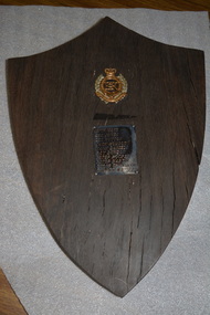 Wangaratta RSL Sub Branch
Memorabilia - Shield, Original punt was made in the mid 1800s. shield was made by Jim Sloan in early 1970s
Red gum shield was made from a piece of the Ovens River punt which served as a river crossing at the Sydney Hotel two centuries ago and which had lain on the river bed for approximately 100 years. The punt was raised by members of the Royal Australian Engineers whose names, unit and badge apear on the shield in the early 1970s.Red gum shield was made from a piece of the Ovens River punt which served as a river crossing at the Sydney Hotel two centuries ago and which had lain on the river bed for approximately 100 years. The punt was raised by members of the Royal Australian Engineers whose names, unit and badge appear on the shield in the early 1970s. In 2019, after nearly 70 years at Balcke House, the Wangaratta RSL Sub Branch will take up new residence at the Sydney Hotel.Red Gum timber in shape of shield with crest and plaque.Crown of Australian Engineers above a list of the soldiers who worked on the project. Attached is a card which states :- This red gum shield was made from a piece of the Ovens River punt which served as a river crossing at the Sydney Hotel two centuries ago and which had lain on the river bed for approximately 100 years. The punt was raised by members of the Royal Australian Engineers whose names, unit and badge appear on the shield in the early 1970s. It was made and presented to the Wangaratta RSL by Jim Sloan of Wangaratta.ovens river, sydney hotel wangaratta -
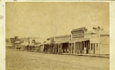 Charlton Golden Grains Museum Inc
Photograph
Early photograph of the west end, northern side of High St Charlton 1880's. Globe Hotel built 1874, Mounted, sepia toned photograph of High St Charlton looking north west. Buildings left to right: residence, Mechanics Institute, general store, shop, Stowe's fruit & veg shop, Globe Hotel, bank (?), T.H. Jackson butcher, O'Sullivan Paintermechanics institure, stowes, globe hotel, t.h.jackson butchers, o'sullivan painter, high street, charlton -
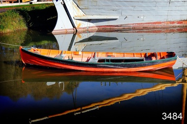 Flagstaff Hill Maritime Museum and Village
Vehicle - Vessel, Dinghy, Proudfoot's Boat, c. 1885
This boat or dinghy is one of a few remaining boats made for Proudfoot’s Boathouse, 2 Simpson Street Warrnambool, on the Hopkins River, in about 1885. It was one of many rowing, fishing, sailing and picnic boats that were available to hire. Proudfoot’s Boathouse, a beautiful Victorian Period building, was designed, built and established by Thomas Proudfoot. He applied to build a boat jetty in 1885. He died in 1900 and his wife Catherine took over, running it for many years. Later her son Bruce and after that her granddaughter Ena Hunt and her husband took over; it remained in the family until 1979. Proudfoot’s was a very popular tourist destination for visitors coming from Melbourne to fish and row and enjoy afternoon tea. The buildings, including the ‘U’ shaped jetty and tearooms, were restored and modified in the 1990s by the Warrnambool Sports Club, under the control of the Warrnambool City Council. The dinghy was brought to Flagstaff Hill in about 1992 and restored to its original condition and painted in traditional paint colours of orange with dark green gunnel and black and gold pinstripes. Since that time it has been painted by Flagstaff Hill's boatbuilder.This dinghy, Proudfoot’s Boat, is significant for its association with Proudfoot’s Boathouse, which is listed on the Victorian Heritage Register, VHR H0620. “Proudfoot's Boathouse on the Hopkins River near Warrnambool is an outstanding example of a late-19th century boathouse complex with associated residences and jetties. Thomas Proudfoot first applied for a jetty licence in 1885 with a view to establishing a boating business on the Hopkins River. The early single-storey sections are thought to date from this period. The two storey second stage probably dates from 1893 when additions were constructed. The entire complex was designed and built by Proudfoot himself. The business remained in the Proudfoot family until 1979. The buildings were modified in the 1990s in the process of creating a sporting club on the site. Proudfoot's Boathouse is of architectural, historical and social significance to the State of Victoria. Proudfoot's Boathouse is of architectural significance as perhaps the finest example of a 19th-century boathouse in Victoria. Although recent modifications have reduced the intactness of the buildings, many original features remain. The beautifully ornamented buildings still provide an attractive instance of 19th-century leisure facility architecture. Proudfoot's Boathouse is of historical significance as an example of late-Victorian recreational and tourist facilities. Boathouses were popular 19th-century tourist and recreational attractions, providing refined and healthy activity. This boathouse shows the early realisation of the tourism and leisure potential of seaside towns such as Warrnambool, a potential that has become increasingly important as port uses have ceased and other industries have been subjected to financial pressure. Proudfoot's Boathouse is of social significance because it illustrates the continuity of the attraction of this kind of leisure facility. Although the glory days of the boathouse were in the 19th century, those that survive continue to be well patronised. Proudfoot's Boathouse has been an important recreational facility and attraction for tourists flocking to the Hopkins River, one of the State's most popular boating and fishing resorts, since 1885.” (Statement of Significance is from the Victorian Heritage Register)Wooden vessel or boat, called a dinghy, known as Proudfoot’s Boat. Paint work is orange with dark green gunnel and black stripe. The rowboat is propelled by oars and has two pair of thole set into the gunnel (gunwale) to hold the oars in place and to serve as a fulcrum when rowing. The boat is dated around 1885. flagstaff hill, warrnambool, shipwrecked coast, flagstaff hill maritime museum, maritime museum, shipwreck coast, flagstaff hill maritime village, great ocean road, small marine vessel, dinghy, proudfoot's boat, proudfoot's boathouse, picnic boat, orange and black boat -
Bendigo Historical Society Inc.
Document - John Beebe's Observatory Bendigo, Peter Anderson's article 2020
John Beebe was born in Sandhurst (Bendigo) in 1866. In his earlier years, John and his brother William operated a stonemason's business in Bendigo, designing and making monuments. John graduated as an architect in 1900 . By 1910, John was in sole practice in Bendigo, when he was appointed as architect for the Anglican Diocese. His churches from this period St. Paul's bluestone church in Axedale and St. John's in North Bendigo. He moved to Brisbane in 1916, possibly for health reasons. He died on 15 December 1936 and is buried in the Lutwyche cemetery in Brisbane in an unmarked grave. Lutwyche Cemetery Kedron, Brisbane City, Queensland, Australia Plot MONUMENTAL-COE3-25A-21 https://www.findagrave.com/memorial/239489809/john-beebe Four page collection of research on the observatory built by John Beebe at his residence at 55 Condon Street, Kennington. Articles are: one page brief biography "John Beebe's Observatory in Condon Street'; includes mention of how he acquired the telescope that was built into the brick observatory at Condon Street. "the building is a very rare survivor and an important relic of late 19 century scientific endeavour in Bendigo and should be placed on the Victorian Heritage Register'. Second article: two pages 'John Beebe, Architect, owner of East Bendigo Observatory. His later life in Queensland 1916 - 1936, by Peter Anderson April 2020. Article includes family history; John Beebe earlier life' John's brother William and his son Wilfred John Beebe; John's career in Bendigo; Astronomy in Bendigo; Fellowship of the Royal Astronomical Society and the move to Brisbane, Queensland and speculation upon the reasons. Third article: 'Our heritage in danger - amazing observatory comes to light' by Mike Butcher. Article addresses the significance of Beebe's observatory building ' and is representative of the city's early endeavours into scientific research'. At end of article a colour photo of the observatory with the heading 'John Beebe's observatory in Condon Street under threat of demolition'. john beebe, william beebe, observatory, 55 condon street kennington, stonemason, architect, st. pauls axedale, st. john's north bendigo, heritage significance -
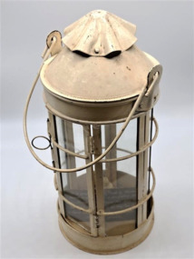 Glenelg Shire Council Cultural Collection
Domestic object - Lantern, Thomas Ward, 1884
This lantern was made by Thomas Ward in 1884 for his daughter Alice Fawthrop Ward to see her way to the little church Wellington Road, where she played the organ for the mid week service. An early example of lighting used in the late 1800s. Additionally this particular light was made by Thomas Ward who was a part of a prominent family in Portland at the time. Thomas was part of the crew that went out to the Admella Shipwreck. The above mentioned church was built in 1870, and is now part of a private residence. Metal lantern painted cream. Round base with 6 rectangle shaped glass panels with 2 curved reinforced metal braces rounding the circumference of the body. One of the panels is a functioning door to allow candle access, door is secured by a thin pin with a ring pull to slide pin up and down. Top is domed with a decorative waves cap. Thin metal carry handle attached by two side braces. Cylinder holder in the base for a candle, and contains a small new looking candle.Hand written label: This lantern was made by Thomas Ward in 1884 for his daughter Alice Fawthrop Ward to see her way to the little church Wellington Road, where she played the organ for the mid week service.thomas ward, city of portland, lantern, alice ward, church, admella shipwreck, portland lifeboat -
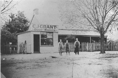 Bacchus Marsh & District Historical Society
Photograph, C.J. Grant, Bootmaker's Shop, corner of Grant Street and Waddell Street, Bacchus Marsh, circa 1907-1909
Charles Grant opened a boot makers business on the northern corner of Grant Street and Waddell Street in 1907. The business was advertised as being in Maddingley Road. By early 1910 the business had moved to 'Ryan's Corner' on the corner of Main Street and Gell Street, Bacchus Marsh. The brick house behind the boot maker's shop was built for Alexander Murdoch in 1869. It was used as a residence, a boarding house and as part of a business by a number of different owners over many years. It was known as the Murdoch house and also as 'Links Cottage' when it was used as a boarding house. For most of the twentieth century it was used as a residence. It was demolished in 1997 to make way for new residences.Black and white photograph print. A reproduction of an original photograph which is mounted on board. The image shows a boot maker's business and a brick house behind it. Standing in front of the shop on the footpath are three men wearing aprons.boot makers bacchus marsh victoria, shops bacchus marsh, houses bacchus marsh -
 Ringwood and District Historical Society
Photograph, C. Gribble, Oliver Pratt's residence and Butchers Shop, Main Road (Opposite Mt.Dandenong Road), Ringwood. Two photos c.1910 and c.1914 (Multiple Copies)
Multiple copies of two photos of Oliver Pratt's residence and butchers shop, Main Road (Opposite Mt.Dandenong Road). Earlier photo shows Mr. Oliver Pratt (Left) and Mr. James Kenneth McCaskill (Right) outside residence (c.1910). Later photo (c.1914) taken after Pratt's first butcher shop was added before subsequent shop established on the corner of Warrandyte Road. (Orignial photo IDs were MHE999, MHE7, F27)Written on back of sepia photograph, "Mr. J. K. McGaskill. Main Road on Pratt's Land?" Typed below another photograph, "Mr. O. J. Pratt's Butcher shop, Main St. east of Warrandyte Rd. - 1912. -
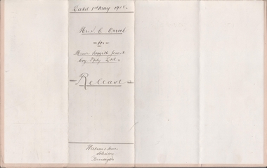 Bendigo Historical Society Inc.
Legal record - FOGGITT JONES & CO. Land sale notes, Watson, James & Rogers, Rogers Collection, 1.7.1913
In the early 1980s the firm of Watson, James & Rogers merged with the partnership of Every & Every and became the iconic “Rogers & Every” as known today. The firm is still located on Bull Street. https://rogersevery.com.au/about/Sale notes to sell land in (Residence Areas), Wade St. Golden Square to Foggitt Jones & Co. Sold all Rights to Titles and Interests. Typed on light brown paper. 1. Joseph Mitchell and Mary Ann Roberts (10317 and 10318) 2. Elizabeth Roberts (10319) 3. Alice Emily Ann Roberts (13126) 4. John Frances Roberts (10363) 5. William Davies Osborne (9805) Release by Mrs Irene Catherine Orrock for Foggitt Jones & Co. handwritten on cream coloured paper.Signatures.land sales, foggitt jones and co. -
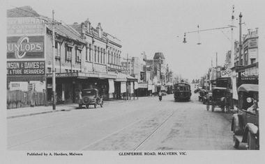 Melbourne Tram Museum
Photograph - M&MTB W class 255 in Glenferrie Rd, Malvern, Rose Stereograph Co, 1920s
The photograph shows Melbourne and Metropolitan Tramways Board W class tram 255 in Glenferrie Rd showing destination Victoria Bridge. The tramcar is in the mid ground and Glenferrie Rd is lined with retail shop verandahs on the ground floor and ornate second floor residences or workshops. Span poles hold the tramway overhead and several early motor cars are seen along the roadway.Yields information about Glenferries Rd and M&MTBBlack and white photograph with writing on the rear.Printed Post Card by Rose Stereograph, Armadale with ink stamp reading "K J Magor No." glenferrie rd, melbourne and metropolitan tramways board, w class, tram 255, victoria bridge, span poles, retail shop verandahs -
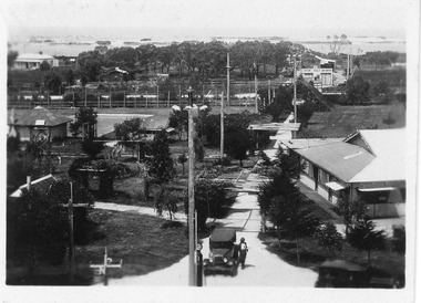 Lakes Entrance Historical Society
Photograph - Whiter's Camp Park, 1928c
Also postcard size black and white same scene but larger view with two vehicles, with inscription-General view Lakes camping park showing homestead.|Larger copy has the inscription Beautiful view of park from Whiters Lookout Tower.Black and white photograph of Whiters Park, showing residence and office, gardens, tennis court, early model car by the petrol bowser, electric lights on tall poles. Opposite park entry is Aults Motor Engineer, scattered cottages. In distance is Cunninghame Arm, sand hummocks and ocean. Lakes Entrance Victoriaresort, township, transport, recreation -
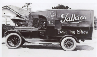 Lakes Entrance Historical Society
Photograph, Travelling Movie Truck, 1920 c
Belonging to John Reardon who took film shows from Lakes Entrance to Orbost from late 1910 to early 1920s. Advertising signs painted on vehicle believed to be parked outside residence in Lakes Entrance Victoria c1920Black and white digital photograph of the travelling movie show truck c 1920cinema, social history, vehicles, advertising