Showing 262 items
matching eucalyptus road
-
 Coal Creek Community Park & Museum
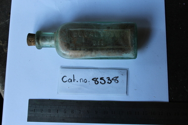
Glass Bottle
... Coal Creek Community Park & Museum 12 Silkstone Road ...small clear oval shaped glass bottle with untacked cork inserted. Eucalyptus Oil -
 Coal Creek Community Park & Museum
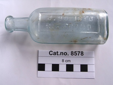
Bottle, glass
'M' monogram on the base of the glass bottle was used by the Melbourne Glass Bottle Company during 1900-1912.Clear aqua tinted, oval in section, glass bottle with text embossed on side and base.'J BOSISTOW RICHMOND' on side. 'M' on base.eucalyptus oil -
 Coal Creek Community Park & Museum
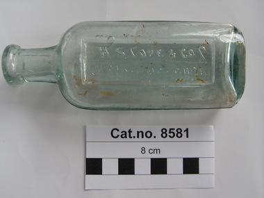
Bottle, glass, 1914-1916
TROVE : Maryborough and Dunolly Advertiser (Vic. : 1914 - 1918) Monday 5 January 1914 p 4 Advertising 'QUALITY EXCELS. H. S. COPE & CO., STATION BRAND. REFINED EUCALYPTUS OIL ONCE TRIED ALWAYS USED. H. S. COPE & CO, MARYBOROUGH.' TROVE : Ararat Chronicle and Willaura and Lake Bolac Districts Recorder (Vic. : 1914 - 1918) Tuesday 5 September 1916 p 2 Article 'H. S. Cope and Co., of Mori Mori, was badly injured by being kicked on the thigh by a young pony whilst he was endeavoring to catch his own for the purpose of driving to his home. He was unable to walk without assistance as a result of the kick, and it will be some time before he completely recovers from the effects.'Clear green tinted glass bottle , oval in section with text on side and monogram on base embossed onto the glass.'H S COPE & CO MARYBOROUGH' on side. A G M on base. -
 Tatura Irrigation & Wartime Camps Museum
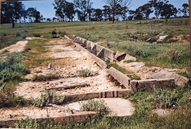
Photograph, Arthur Knee, Camp 13 latrine block remains, 1989
Camp 13, German compound. Latrine block, concrete remains, eucalyptus in background.Camp 13, Camp Road, Murchison, Victoria. Concrete remains, latrine block.camp 13, pow, german pow, internment camps, ruins, murchison victoria, latrine remains camp 13 -
 Tatura Irrigation & Wartime Camps Museum
Photograph, Arthur Knee, Memorial to Kormoran Komeraden, 1989
Camp 13, German compound. Memorial erected by German POW's to honour their comrades on the German Raider "Kormoran" which sank HMAS Sydney in the Indian ocean before going down, too.Camp 13, Camp Road, Murchison, Victoria. Memorial to fallen comrades, German compound. Concrete with local stone. German inscription on rectangular recessed area to "Kormoran" crew. Note. concrete machine gun emplacement (background), Eucalyptus bush distant background.camp 13, german pow's, kormoran, hmas sydney, memorial, german raider kormoran, german memorial, kormoran memorial, kormoran komeraden -
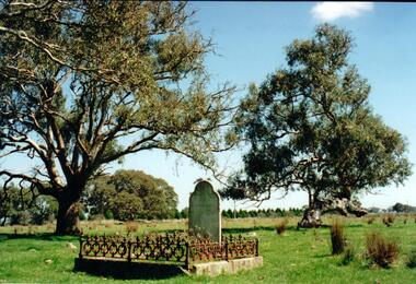 Hume City Civic Collection
Photograph
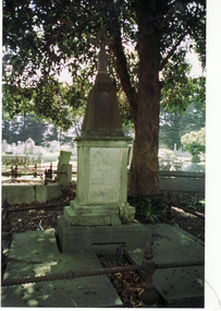
The grave is that of Martha Williams and her father John and is the only existing grave in the old Mickleham Cemetery which was associated with the Wesleyan Chapel and is a reminder of the strength of the Wesleyan faith in the Mickleham district in the 19th century.A coloured photograph of a grave site with a concrete edge and low iron fence around it and a simple tombstone with a curved top. There are clumps of tussocky grass scattered across the grass and two sprawling eucalyptus are growing behind the grave.former mickleham cemetery, mt. ridley road, williams, martha, john, george evans collection -
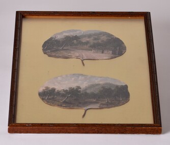 Chiltern Athenaeum Trust
Painting - Oil painting on gumleaf by Alfred William Eustace, circa 1851 to 1907
This gum leaf painting is one of a pair displayed on foil in the same frame. It is typical of many paintings by the self-taught Australian artist Alfred William Eustace (1820-1907). A.W. Eustace, a well-known Australian artist, was born in Berkshire, England, where he was an assistant gamekeeper to the Earl of Craven at Ashdown Park. He migrated to Australia with his wife and children in 1851 and camped on the Ullina and Eldorado Runs on the Black Dog Creek at Chiltern, which was in excess of 50,000 acres of grazing land. A.W. Eustace was employed as a shepherd by Jason Withers and while tending his flocks in the solitude of the bush, Eustace turned his attention to painting and music to while away the long and weary hours. He endeavoured to capture the spirit of the bush painting on board, canvas or tin plate, but as these materials were not always readily available he then started painting on large round eucalyptus leaves from the White and Red Box trees that grew around about him. About 1856 he painted a small picture of the famous Woolshed goldrush and during the next few years became well known in North-East Victoria. John Sadlier, a police officer stationed at Beechworth said that Eustace painted 'some really exquisite scenes. He was of an easy-going dreamy temperament, a student of nature only, despising the works of men. Unfortunately his drawings were on eucalyptus leaves, the largest and roundest he could find and not on canvas, and no doubt have all perished long ago.' In 1876 the Melbourne Age newspaper reported, 'Eustace’s celebrated paintings on gum leaves are again attracting attention,…Mr Eustace is an elegant artist…he seems without effort to catch the colour and spirit of Australian scenery…' In 1864 A.W. Eustace held an Art Union in Albury, and again in 1884 in Ballarat. He exhibited at the Victorian Academy of Arts in 1877 and also held an exhibition of gum leaf paintings at Stevens Gallery, Melbourne in 1893. By 1896 he was receiving orders from heads of states in Europe, with his works acknowledged by Queen Victoria, Emperor Frederick of Germany and the Czar of Russia, as well as the Governors of New South Wales and Victoria. His paintings reflected his ability to paint the sky in his realistic style which is still noted by art critics of the day. A.W. Eustace was also a skillful taxidermist. The collection of birds and animals that can be seen at the Beechworth Museum are examples of his taxidermy skill. When not doing his work, painting or taxidermy, he regularly contributed letters and verse to the Chiltern newspaper, The Federal Standard. A book of verse in his hand writing was presented to The Athenaeum Trust by the Boadle family. In the 1870’s he became interested in spiritualism often being involved in lively debate at lectures and séances. Alfred William Eustace died in 1907 and is buried in the Chiltern New Cemetery with his wife Sarah and one of his daughters, Elizabeth.An oil painting on gum leaf by the well-known Australian artist Alfred William Eustace. He was a self-taught artist during the 19th and early 20th century and a prominent resident of Chiltern. Oil painting on gum leaf by Alfred William Eustace. A scene of a log cabin on Black Dog Creek Road, Chiltern, with Skeleton Hill in the background. The canvas is a juvenile Red Box (Eucalyptus polyanthemos) leaf. It is one of a pair of Eustace gum leaf paintings mounted on gold foil, under glass in a brown frame. Inscription on back. Labels on back: Rehoused by The Centre for Cultural Materials/ Conservation, University of Melbourne "Oil on Gum Leaf"/ by Alfred William Eustace/ Donor:- Cam & Connie Boadle/ Wales U.K. Crescent/ MUSEUM/ GRADE/ 24 OCT 1998/ CONSERVATION BOARD ALBURY/ PICTURE FRAMERS/ Shop 15 & 16/ AMP Lane,/ Albury, 2640/ Ph: 02 6021 7088black dog creek, chiltern, alfred eustace, skeleton hill, gum leaf, painting, eustace -
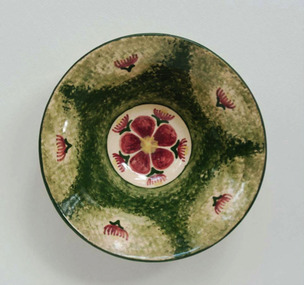 Duldig Studio museum + sculpture garden
Ceramic, Karl Duldig, Gumnut Bowl by Karl Duldig c.1948, c. 1948
Karl Duldig’s ceramic bowl is a particularly interesting example of Karl’s ability to creatively respond to a new environment with a fresh visual repertoire, in this case, the flowering Eucalyptus in a design reminiscent of traditional European folk art. The bowl is an excellent example of the utilitarian and decorative studio pottery produced by Karl and his wife Slawa Horowitz-Duldig between 1944 and 1960. Clay was an important medium for Karl. When he was forced to flee Austria for Switzerland, working with clay became a convenient medium; and he continued to expand his use of clay in Singapore. In Australia his work in clay extended from domestic hand-made pottery to public sculptures and architectural reliefs. In 1944 Duldig purchased a kiln, which was installed in the garage of the family’s St. Kilda flat, soon after a pottery wheel was acquired. It was the beginning of a cottage industry that supplemented the family income during the war years and beyond. Duldig initially sold his decorative ceramic wares through a local florist in St. Kilda, and subsequently through shops such as the Chez Nous French Art Shop (Howey Place) and Light and Shade (Royal Arcade), and the Primrose Pottery shop in Collins Street. The Primrose Pottery shop was an extremely important commercial outlet, and hub, for emerging artists, potters and designers from 1929 until 1974. Its proprietors Edith and Betty MacMillan worked closely with their suppliers, commissioning and taking items on consignment. In the post war period important Melbourne studio potters such as Allan Lowe, Arthur Boyd, John Perceval and Neil Douglas exhibited and sold domestic wares in the Primrose Pottery shop. The Duldigs studio pottery provides a counterpoint to the ceramics produced at Arthur Merric Boyd Pottery in Murrumbeena, which was established in 1944 by Arthur Boyd, John Perceval and Peter Herbst. The emphasis on painterly decoration was important and the AMB potters also produced simple household wares decorated with Australian flora and wildlife, for example Neil Douglas also made small bowls decorated with the fairy wrens, lyrebirds, gumnuts and eucalypts. Ann Carew 2016The Duldig Studio’s collection of ceramics has national aesthetic and historic significance. It contains a representative sample of works of art in ceramics created by Karl Duldig during his lifetime, including small sculptures, as well as functional and novelty items for the tourist market during the 1956 Melbourne Olympic Games. The artist’s working methods and the development of his practice are comprehensively demonstrated in the collection. This in-situ collection demonstrates the philosophy of the Vienna Secession and its inheritors that handcrafted, simple functional domestic wares might enrich both the lives of the maker and the user. This bowl is part of a collection of ceramics that has national historic significance in providing a rich illustration of an immigrant and artistic experience, and touching on the themes of settlement adaptation of artistic practice. The collection is also associated with places of cultural and historical significance in Melbourne such as the Primrose Pottery Shop, and the story of Australian studio ceramics in the post-war years. Ann Carew 2016Cream earthenware bowl with flowering gum motif and sponged green background.Duldig in script incised under. -
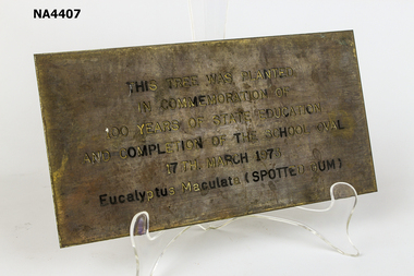 Whitehorse Historical Society Inc.
Plaque - Commemorative Plaque, 1970s
Brass commemorative plaque. This Tree was planted in commemoration of 100 years of State Education and completion of the school oval 17th March 1973. Eucalyptus Maculata (Spotted Gum)As aboveschool, equipment -
 Whitehorse Historical Society Inc.
Pamphlet, Schwerkolt Cottage, City of Nunawading, c1980
Schwerkolt Cottage and Historical Museum: Nunawading Parks and Recreation Information, includes advertisements for 'Colonial' Eucalyptus Oil and lanolin based souvenir soaps.schwerkolt cottage, city of nunawading. parks and recreation services -
 Whitehorse Historical Society Inc.
Photograph, Tombstone - Slater family
William Henry Slater emigrated from England and began growing medicinal herbs near Koonung Creek, Blackburn North in 1862. He also distilled eucalyptus oil for use at Melbourne Hospital and it was exported overseas under the 'O'Possum' brand. He later replanted his land with orchards but land taxes and rates forced the sale of the property. In 1979 the Nunawading Council purchased 7 acres of the land, now called , Slater ReserveColour photograph of the Slater family tombstone at Box Hill Cemetery. William Henry Slater died 23 May 1894 - 66 years of age Mary Ann Slater died 12 August 1912 - 83 years of ageslater, william henry, mary ann, herb farms, slater reserve -
 Bendigo Historical Society Inc.
Document - PETER ELLIS COLLECTION: A GUIDE FOR DRIVERS ON THE WHIPSTICK TOUR
A Guide for Drivers on the Whipstick Tour. First page gives assembly area, driving in convoy and negotiating water or boggy patches across the road. Amended written at the end of the page. Directions with mileage and items of interest for the tour on Sunday September 9th (no year). A Whipstick Map 1971 showing State Forest, Crown Lands, Uncleared Mallee - Private (shown in different colours) Water Reserve and Roads. Noted are Flora and Fauna - Plants, Birds & Mammals, and areas of State Forest and Southern State Forest with Mallee Scrub area noted. Also State Forest & Crown Lands Total Area and a map scale. The Bendigo Whipstick mentions area, suggestions of where the name Whipstick came from, shrubs and flowers with their flowering times, descriptions of some of them and some information on the Mallee Fowl. The Eucalyptus Oil Industry paragraph mentions the beginnings of the industry. Mentioned are the different uses of oils (perfumery, industrial and medicinal) and the different species of eucalypt used for each and various products. Also notes on the growing, harvesting and refining of eucalyptus. P Ellis at the end of the page. The next two and a half pages mentions reserves, and at the end acknowledgements. Includes a spare copy of 'The Bendigo Whipstick' by P Ellis.bendigo, history, early bendigo, peter ellis collection, a guide for drivers on the whipstick tour, the whipstick 1971 map, shire of marong, shire of east loddon, shire of huntly, borough of eaglehawk, city of bendigo, shire of strathfieldsaye, the bendigo whipstick, eucalyptus oil industry, eaglehawk town hall, lightning hill lookout, eaglehawk rifle range, new moon mines, blue jacket reservoir, maggetti's wine hall, camp hotel (ex), skylark dam, eucalyptus oil production, eucalyptus factory, whipstick eucalyptus farm, ruedin's eucalyptus factory, dutch bowls, governor philip, sir joseph banks, john white, baron von mueller, joseph bosisto, commonwealth government, perfumery oils, industrial oils, medicinal oils, p ellis, dr frith, csiro wildlife division, harley webster, forests commission, vincent serventy, victorian national parks association, bendigo field naturalists club -
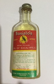
 Friends of Westgarthtown
Bottle
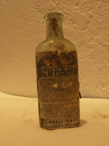
Clear glass bottle oval shaped. Embossed on back J. Bosisto Richmond. Paper label on front reads "Bossisto's Parrot Brand Oil of Eucalyptus".Paper label on front of bottle reads " A valuable external remedy for rheumatism lumbago, sciatica, sprains, chilblains, whooping cough, Croop, asthma, bronchitis, sore throat and all other painful afflictions whenever stimulating applications is required. The oil taken internally in five to six drop doses on loaf sugar and inhaled over hot water is recognised as many medical authorities as almost a specific in the treatment of common cold and influenza. A few drops sprinkled on a cloth and suspended in a sick room renders the air refreshing. Rubbed lightly on the face and hands it prevents attacks from mosquitoes. Full directions for use on full wrapper around bottle. Bosistos Eucalyptus Oil is the genbuine essence of the Tree distilled from E. Ihumosa and other speicies best known to contain the medicial purposes of the oil in the most perfect combination for general medical use. Embossed on back of bottle reads J. Bosisto Richmond.medicine, first aid, bosisto, richmond, eucalyptus, domestic, remedy, oil. -
 Surrey Hills Historical Society Collection
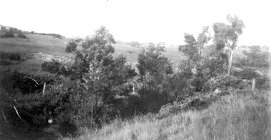
Photograph, View from Goodwood Street, Surrey Hills in 1930, 1930
The Breeden family came to Surrey Hills in 1905, first to Guildford Road, then Middlesex Road where Horrie Breeden lived as a boy. He sometimes used to help with milking at the adjoining Kenneally's dairy in Highfield Road. Sometimes he and his brother drove the cows from there to Schneider's property near Florence Road on the way to Surrey Hills Primary School. The cows would graze here until the boys took them back after school. At other times he would deliver milk from the Croydon Road dairy (Isherwood's or Bovill's) to St Joseph's Boys Home before school. Horrie became an apprentice in woodwork / carpentry at Vine's timber yard before serving in World War 1. Horrie's father died in 1919 and in the same year he bought 3 cows and established his own dairy on his mother's property on the corner of Goodwood Street and Boisdale Road. In the 1920s Horrie built the first house in Goodwood Street. He went on to build others in the street including his own at No 7 Goodwood Street. He did all the joinery and internal fittings for this. [REF: Oral testimony: Horrie Breeden to Jocelyn Hall in 1979.] In the 1990s the owner of 7 Goodwood Street discovered a branding iron under the house; this is presumed to relate to Horrie Breeden's dairy. It was donated to SHNC's collection. Horrace Bruce Breeden (7 July 1898-24 January 1988) was son of Charles Henry Breeden and Lavinia Maria Darby, both born Warwickshire; buried in Box Hill Cemetery. He was one of a large family. He married Olive Mary Romey.Black and white photo taken from the east end of Goodwood Street, Surrey Hills in 1930, looking towards Elgar and Riversdale Roads. It shows an area which is rural in appearance. It is not built upon. The foreground is grassy and there is a post-and-wire fence to the right. There is a bank of eucalyptus trees behind which is hilly grassland.goodwood street, dairies, horace breeden, horrie breeden -
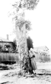 Surrey Hills Historical Society Collection
Photograph, Everton Grove, Surrey Hills c 1925, 1925
The date is approximate.Black and white photo of a large eucalyptus tree which appears to have had its canopy pruned. A woman in a cloche hat, identified as Mrs Mabel Carter, is leaning against it as if reading. In the background is a paling fence, beyond which is a weatherboard house and (?) a later brick house. The area between the foreground and the paling fence is roughly grassed without a footpath. About 10 feet up the trunk of the tree a wooden sign can just be distinguished. This is the street sign for Everton Grove. Norman and Mabel Carter lived at 21 Everton Grove. Norman took many photos of Surrey Hills and Mont Albert from the 1920s, in particular of events and activities of the Church of England.everton grove, trees, norman brodley carter, mrs mabel annie carter, miss mabel annie moore -
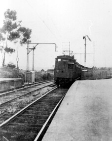 Surrey Hills Historical Society Collection
Photograph, Early electric train at Mont Albert Station, c1926, 1926
Date is approximate. Electric trains replaced steam locomotives in 1922. Mr William Holmes of 'Lugano', Mont Albert Road was in charge of the design and introduction of the electrification of the Melbourne rail system.Black and white photo of an early electric train approaching the platform at Mont Albert station. A couple of spindly eucalyptus trees can be seen beyond the picket fence marking the boundary of the platform.Black and white photo mounted on card; measures 16.3 cm x 23.4 cm.mont albert station, railways, trains, norman carter -
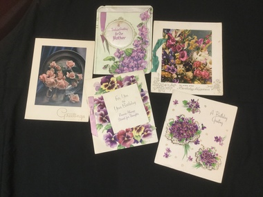 Mont De Lancey
Card - Greeting cards, Specialty Hallmark, 1950's
Five highly decorative floral birthday greeting cards from the 1950's. Three have ribbon decoration in pink, green and purple.Greetings written inside from 'Netta & Neville, Mary or Eva'. On the back of the pink roses card, handwritten in pink pencil '1 Camphor in Eucalyptus, 1/2 teas menthol, Olive Oil' greeting cards, birthday cards -
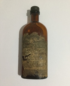 Mont De Lancey
Glass bottle, J. Bosisto & Co. Pty. Ltd
Small, brown Bosisto's oil bottle with metal screw on top. The label on the front of the bottle is in poor condition.On label: "Bosisto's Parrot Brand oil of eucalyptus" with the parrot logo. Instructions are: "Use externally as a liniment (either mixed with olive, peanut or persic oil or used "neat") for rheumatism, whooping cough, croup, bronchitis, sore throat, lumbago, strains etc. Originally, take three drops on a tissue or as an inhalation with one teaspoon in a jug of ?. A few drops may also be sprinkled on your pillow. Repels mosquitoes. Bosisto's Parrot Brand eucalyptus oil is wholly Australian and is the result of over ninety years of experience in the manufacture of this fine product". Two columns run down either side of the label. On base: "9611".bottles -
 Mont De Lancey
Glass bottle, J. Bosisto & Co. Pty. Ltd
Small glass bottle with red, white and green label and a metal screw on cap. Half full of oil.On label: "Bosisto's Parrot Brand double distilled Oil of eucalyptus. Around the base of the circular Parrot Brand logo: "Trade Mark Regd.". "Directions for use: As an inhalation for the relief of the coughs of colds, pour in a teaspoonful into a jug of boiling water. As an embrocation for the relief of sprains, strains and other muscular disorders, rub freely into the affected parts. Contents: 2 fl. oz. Reg. Vic. No. 7299. Guaranteed B.P.. D.H.A (Laboratories) Pty. Ltd. Australia. On Base: "ISM 948".bottles -
 Bendigo Historical Society Inc.
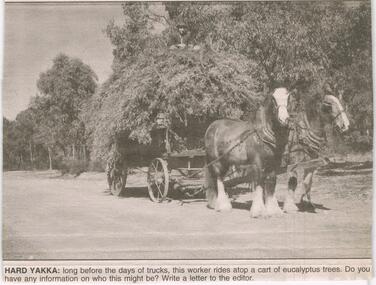
Newspaper - JENNY FOLEY COLLECTION: HARD YAKKA
Bendigo Advertiser ''The way we were'' from 2003. Hard yakka: long before the days of trucks, this worker rides atop a cart of eucalyptus trees. Bendigo Advertiser from 2003. The man on the cart identified: the man is John Notley and was working for his father Lou Notley. Lou and son lived on Neilborough Road, Whipstick. The photo was taken some time in the early 1950s. Letter written by Ernie Hartland, Bendigo.newspaper, bendigo advertiser, the way we were -
 Eltham District Historical Society Inc
Photograph - Digital Photograph, Marguerite Marshall, Hawthorn hedges, Eltham-Yarra Glen Road, Kangaroo Ground, 3 October 2006
Hawthorn hedges are important reminders of Kangaroo Ground's Scottish heritage. They are Registered on the Victorian Heritage Register. They are "historically significant because the planting of hawthorn hedges reflects the adoption of Eurorpean farming techniques by the Kangaroo Ground population in the period following settlement and because the grid pattern of paddocks that the Hawthorn hedges define is very different to today's farm landscapes." Covered under Heritage Overlay, Nillumbik Planning Scheme. Published: Nillumbik Now and Then / Marguerite Marshall 2008; photographs Alan King with Marguerite Marshall.; p21 Hawthorn hedges bordering Kangaroo Ground’s gently rolling farmlands are important reminders of its Scottish heritage and are rare so close to Melbourne.1 As early as the 1840s newly arrived farmers from Scotland planted hawthorn hedges around their properties, to protect crops from the numerous kangaroos and wallabies. Many of these hedges survive today. These farmers had the good fortune to settle some of the most fertile land available for cropping in the Colony of Victoria. At that time the black volcanic soil could sustain an amazing two crops a year. By the mid 1850s, 500 acres (202ha) of wheat were growing in Kangaroo Ground. But the crops were threatened by kangaroos, which were so plentiful, that Surveyor-General, Robert Hoddle, named the district Kangaroo Ground in 1838. As post-and-rail fences proved inadequate barriers for the bounding kangaroos, the Scots planted hawthorn hedgerows as they had done in Scotland. Some also used the hedges to net birds, presumably for the table. Interestingly the farmers in the bordering townships of Panton Hill and Christmas Hills, did not plant hawthorn hedges around their properties. Perhaps it was because by the time they settled in the 1860s and 1870s most of the wildlife had been gunned down by residents.2 The canny Scots planted the hedges on public land outside their own farms, as the hedgerows could spread to about five yards (five m) in width. With this impenetrable barrier Kangaroo Ground’s industrious farmers flourished to gain the economic power that saw the Shire of Eltham governed from Kangaroo Ground for 79 years (1858-1937). The Scots jealously guarded their land, so hard to get in Scotland. That is why they refused to release any of it ‘for local roads to follow easier grades as was the case in surrounding districts where roads generally followed ridgelines or streams’.3 Instead the roads were built in accordance with the magnetic bearings of their first survey in 1847 whether that suited the steep topography or not. This could force traffic to diverge when wet through Greensborough and Diamond Creek. Until 1921, the Eltham-Yarra Glen Road beside Wellers Restaurant, ‘dipped down into the upper reaches of Stony Creek’.4 Later some corners were compulsorily cut for the increasing motor traffic. As late as the 1960s, corners were cut to form sweeping curves above and alongside the Kangaroo Ground Cemetery and opposite the Emergency Operations Centre. In the latter case, the farmers – understanding their hedgerows as important heritage – insisted upon their reinstatement to conform to the altered road alignment. Kangaroo Ground’s ancient manna gums also point to the district’s history and to that of the hedgerows. The Aboriginal people had transformed the original forests into grasslands with the fires they lit to attract kangaroos, (which the Scots were to exclude by planting hedgerows). But the Wurundjeri hunters left the gums (Eucalyptus vimminalis cygnetensis), on the grasslands as ‘stalking trees’ to hunt kangaroos. The hawthorn hedges in Kangaroo Ground were neglected for around 60 years from about the middle of the 20th century. Bushfires had created gaps and the hedgerows were not trimmed. Then in late 2005, local historian Mick Woiwod, formed a group to lobby the Nillumbik Shire to restore the hedges, which could last for many centuries. Some hedges in parts of Britain date back to AD 800.5 Although the original Scottish farmers have gone, the hedges are a reminder of when they flourished in the district, which has changed little in 150 years.This collection of almost 130 photos about places and people within the Shire of Nillumbik, an urban and rural municipality in Melbourne's north, contributes to an understanding of the history of the Shire. Published in 2008 immediately prior to the Black Saturday bushfires of February 7, 2009, it documents sites that were impacted, and in some cases destroyed by the fires. It includes photographs taken especially for the publication, creating a unique time capsule representing the Shire in the early 21st century. It remains the most recent comprehenesive publication devoted to the Shire's history connecting local residents to the past. nillumbik now and then (marshall-king) collection, eltham-yarra glen road, hawthorn hedgerow, kangaroo ground -
 Eltham District Historical Society Inc
Photograph - Digital Photograph, Alan King, Alistair Knox Park, Eltham, 2008
Alistair Knox Park, an oasis of peace and beauty. Covered under National Trust of Australia (Victoria) Landscape Significance and Heritage Overlay, Nillumbik Planning Scheme. Published: Nillumbik Now and Then / Marguerite Marshall 2008; photographs Alan King with Marguerite Marshall.; p173 It is hard to imagine that the Alistair Knox Park, an oasis of peace and beauty beside busy Main Road, Eltham, was once the township’s rubbish dump. It was only in the 1970s that the tip was transformed into this beautiful six hectare space, which later earned it a National Trust Landscape classification. Before its life as a dump, the area was used for small farms. Thanks largely to the foresight and efforts of local environmental builder Alistair Knox, the park was designed sympathetically with the character of the wider Eltham landscape. Then, appropriately, the park was named after Knox, who was an Eltham Shire Councillor from 1971 to 1975 and Shire President in 1975. The park designers were four major forces in the urban bush landscape garden –Knox, landscape designer Gordon Ford, artist Peter Glass and landscaper Ivan Stranger.1 The National Trust citation for the park, originally called Eltham Town Park, includes the Eltham railway trestle bridge and the Shillinglaw Cottage. The citation states ‘the semi-natural setting of the parkland provides a landscape which is evocative of the history of the area’. Manna Gums (Eucalyptus viminalis) and Candlebarks (Eucalyptus rubida) are significant features. Most of the park’s construction was directed by Bob Grant, Superintendent of the Parks and Gardens Department for the Eltham Shire Council. First plantings occurred in Arbour Week in 1973, then the lake and botanic area were completed in 1975, with Federal Government funding, and the toilet block in 1978. Bounded by the Eltham railway line, Panther Place, Main Road, Bridge and Susan Streets, the park is in a valley about a kilometre wide overlooked by steep hills at the east and west. The Diamond Creek flows through it and the picturesque historic timber trestle railway bridge edges the north. Informal plantings of Australian indigenous and native species in open and undulating grassed settings blend with the natural landscape of the Diamond Creek to the west. The bush-style plants, particularly around the creek, balance with open lawns, paths and a cascade flowing from a small lake to another below. A footbridge over the creek leads to the park’s west. The park includes an adventure playground and barbecue areas. The park stands on part of the land bought from the Crown in 1851 by Josiah Holloway, who subdivided it into allotments and which he called Little Eltham. Most of the land was subdivided into residential lots, but the creek valley, on which the park stands, was subdivided into farm-size lots, used mainly for orchards and grazing. One of the earliest owners was John Hicks Petty, who in 1874 bought a plot from Holloway. Other families who owned properties in that area, included Rees, Clark, Waterfall, Graham, Hill and Morant.2 In 1901 the railway was built through the area. Jock Read, an Eltham resident since around 1920, remembers several farms in the 1920s and ’30s that occupied the site of today’s park. A poultry farm, which extended from present day Panther Place, was owned by the Gahan family. Next to that farm was another for grazing cattle owned by Jack Carrucan. Beside this was land owned by John Lyon. A doctor lived beside this, and at the north-west corner of Bridge Street and Main Road stood a memorial to the soldiers who died in World War One, which was later moved to the RSL site. Mr Read also remembers other farms and orchards west of the creek In the early 1960s the Eltham Council began buying these farms and in the late 1960s turned the areas east of the Diamond Creek into a garbage tip. When this was filled above the creek’s flood plain, the tip was moved to the west of the creek.This collection of almost 130 photos about places and people within the Shire of Nillumbik, an urban and rural municipality in Melbourne's north, contributes to an understanding of the history of the Shire. Published in 2008 immediately prior to the Black Saturday bushfires of February 7, 2009, it documents sites that were impacted, and in some cases destroyed by the fires. It includes photographs taken especially for the publication, creating a unique time capsule representing the Shire in the early 21st century. It remains the most recent comprehenesive publication devoted to the Shire's history connecting local residents to the past. nillumbik now and then (marshall-king) collection, alistair knox park, eltham