Showing 3378 items matching "glenferrie"
-
 Vision Australia
Document - Text, Victorian Blind Sports Association letterhead
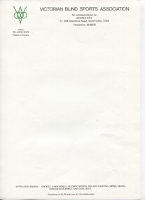
Blank letterhead for documents sent out by the Victorian Blind Sports Association, during 1980's and possibly early 1990's. Logo consists of a large V, with an upside smaller v between to turn the middle into a diamond shape. Three circles overlap across the middle of the diamond/V.Blank A4 paper with Vic Blind Sports logo, address and list of sports covered at basenon-fictionVictorian Blind Sports Association All correspondence to: SECRETARY C/- 454 Glenferrie Road, KOOYONG, 3144 Telephone: 20-8876 Patron: Mr John Cain Premier of Victoria (At base of page:) Affiliated bodies - Cricket, Lawn Bowls, Olympic Sports, Square Dancing, Swish, Skiing, Indoor Bias Bowls and Goal Ball Donations of $2.00 and over are Tax Deductible.elizabeth maxwell, neil maxwell, victorian blind sports association, office equipment and supplies -
 Vision Australia
Card - Text, Invitation to the Official Opening of the Vision Resource Centre
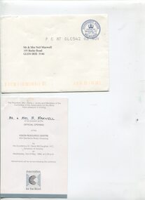
Invitation card to the opening of the Vision Resource Centre at Kooyong in 1989.1 invitation card, white with blue writing and AFB logo, and 1 envelope addressed to Mr and Mrs Neil Maxwellnon-fictionThe President, Mrs Diana J. Jones and Members of the Committee of the Association for the Blind have pleasure in inviting Mr & Mrs N Maxwell to be present at the Official Opening of the Vision Resource Centre 454 Glenferrie Road, Kooyong by His Excellency, Dr Davis McCaughey, A.C. Governor of Victoria, on Wednesday 3rd May 1989, at 2.30pm Refreshments will be served after the ceremony AFB logoassociation for the blind, elizabeth maxwell, neil maxwell -
 Surrey Hills Historical Society Collection
Photograph, 152 Union Road Surrey Hills
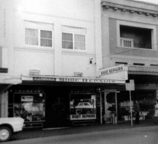
Eric Pringle's boot and shoe repair shop, with Ives fruit shop adjoining were both were both important local businesses. Those who remember Eric said nothing was too difficult or unimportant. He was so dexterous that he could carry on a conversation with tacks in his mouth. Eric James Pringle (c1904-1980) married Lillian May Gertrude Collins in 1928. He had boot making businesses in Glenferrie and Kew before coming to Surrey Hills. He enlisted in WW2 (No V363574). He is first listed at 152 Union Road in 1943. The business continued at this address but the family are listed at 283 Mont Albert Road in later electoral rolls.A black and white photograph of a shoe repair shop. A sign identifies it as E.J. Pringle's shop. There appears to be a residence above the shop.union road, surrey hills, boot makers, eric james pringle -
 Vision Australia
Image, Low Vision Clinic assistance, 1989
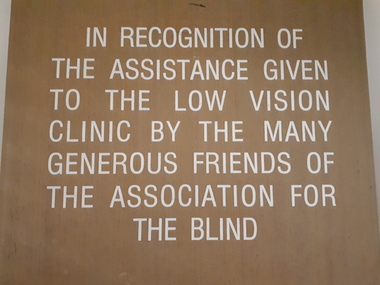
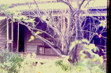
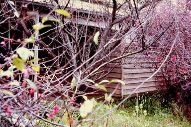
Plaques recognising the funds donated by AFB supporters as part of the Vision Victoria Appeal, that helped build the Vision Resource Centre at Kooyong 1987-1989. The need for services for people with low vision was recognised by the AFB, who undertook to provide a range of services including diagnosis of low vision, advisors on how people with low vision could best utilise their existing sight, and objects designed to assist in everyday living. Initially operating out of a flat facing Glenferrie Road, which the Association had purchased, the growing demand demonstrated that a larger dedicated area was required. Thus began the project to develop a Low Vision Clinic on the land previously occupied by flats eventually purchased by the Association. 2 digital images of wooden board with white etched writingIn recognition of the assistance given the to the Low Vision Clinic by the many generous friends of the Association for the Blind The Association for the Blind acknowledges with appreciation the contribution made to the Low Vision Clinic by the following major donors: The Victorian Government Springfield Auxiliary Kooyong Fair Committee Mr Claude Kingston O.B.E. Mr A.T. Marriott Mr W. P. Fleming Mr A.J. Jennings-Smith H. and L. Hecht Trust Collier Trust William Buckland Foundationassociation for the blind, h & l hecht trust, william buckland trust -
 Melbourne Tram Museum
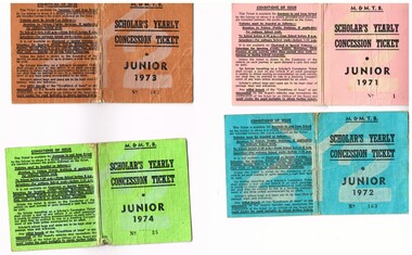
Ephemera - Ticket/s, Melbourne & Metropolitan Tramways Board (MMTB), "Scholar's Yearly Concession Ticket", 1971 to 1974
Set of four clothed backed paper ticket, printed as a MMTB "Scholar's Yearly Concession Ticket", for Juniors. Gives condition of use on the outside cover. Each issued to Roderick Atkins. Each lists the various terms for which they were available and available from Cotham and Glenferrie Road, to Callantinia Road, Scotch College. Two sections. .1 - Pink cloth, Junior 1971, cost $13.50 - No. 1 .2 - blue cloth, Junior 1972, cost $18.00 - No. 163 .3 - brown cloth, Junior 1973, cost $18.00 - No. 162 .4 - Green cloth, Junior 1974, cost $18.00 - No. 25trams, tramways, mmtb, tickets, schools, schools tickets, scholar's tickets -
 Melbourne Tram Museum
Document - Folder of Track crossections drawings, Melbourne & Metropolitan Tramways Board (MMTB), c1928
The document provides cross sections of track used from c1920 to 1928. The folder is marked "H Bell" most likely the son of the later Chairman, Mr Hector Bell who was a civil engineer with the MMTB. 1 - P3948 - Camberwell Road - 1926 2 - P2789 - Camberwell Road reconstruction - 1920 3 - P3753 - Chapel St - 1926 4 - P60 - Expansion joints Church St bridge - 1924 5 - P3686 - Commercial Road reconstruction - 1926 6 - P4024 - Cotham Road reconstruction - 1927 7 - P4699 - Droop St duplication - 1927 8 - P2384 - Flemington Road conversion - 1925 9 - P1187 - Flemington Road tramway - undated c1920 10 - P4131 - Flinders St conversion - 1927 11 - P4132 - Flinders St conversion - special track drains where subject to flooding - 1927 12 - P3603 - Glenferrie Road east track - 1926 13 - P2608 - Glenferrie Road reconstruction - 1925 14 - P3577 - Glen Huntly Road extension - 1926 15 - P3745 - Glen Huntly Rd duplication - 1926 16 - P4655 - Gilbert Rd duplication - 1928 17 - P2472 - Hannah St at Crossings 1925 18 - P2459 - Hannah St in plantations - 1925 19 - P2582 - High St Prahran reconstruction - 1926 20 - P1594 - High St Prahran reconstruction - 1925 21 - P3611 - High St Malvern reconstruction - 1926 22 - P3900 - Lygon St - 1926 23 - P3689 - Malvern Road reconstruction - 1926 24 - P3951 - West Coburg Route - sleeper spacing - 1926 25 - P4703 - Nicholson St Coburg - duplication - 1928 26 - P4470 - Norwood Road duplication - 1927 27 - P2473 - Park St tramway - 1925 28 - P3707 - Riversdale Road reconstruction - 1926 29 - P4630 - Riversdale Road extension - 1927 30 - P4497- Riversdale Road duplication - 1927 31 - P1387 - South Melbourne Road - special boxed in Construction for Albert Road (parking loop) - 1924 32 - P4691 - Swan St reconstruction - 1927 33 - P3640 - Victoria St part - 1926 (2 copies) 34 - P4522 - Wallen Road reconstruction - 1927 35 - P3939 - Wallen Road reconstruction in front of depot - 1927 36 - P4702 - Trial types of track - 1928 37 - P4254 - Wattletree Road reconstruction - 1927 38 - P4531 - Wattletree Road connection to Glenferrie Road - 1927 39 - P4708 - Wellington Rd siding - 1928Yields information about the various tramway track cross sections used by the MMTB including cable tram conversions.Folder - heavy card cloth covers fitted with two interscrews containing some 39 plus one duplicate folded blue prints. Covers made by Swinnerton Bros of Melbourne - see image 6 for their logo/trademark.Has "H Bell" in ink on rear cover.tramways, mmtb, tram tracks, rails, civil engineering, cable conversion, new tramways -
 Vision Australia
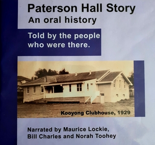
Audio - Sound recording, Paterson Hall Story: an oral history told by the people who were there, 2002
Paterson Hall Story is told through the reminiscences of 23 people who played an active part in the life of a popular recreational and entertainment hub from 1929 to 1999. They relate how a simple concrete structure in Glenferrie Road, Kooyong became a 'home away from home' for people who were blind or vision impaired, their families and friends. The hall was originally built as a clubhouse for blind cricketers in 1927, but by 1929 it had been extended to include a social hall and other facilities including a verandah where spectators could watch the cricket. Over the years the hall was used for activities as diverse as square dancing, singing, craft classes, ball games, art and craft shows, drama groups and annual meetings.60 MP3 sound files of oral history interviews and book excerptsNarrated by Maurice Lockie, Bill Charles and Norah Tooheypaterson hall, association for the advancement of the blind, victorian blind cricket association -
 Melbourne Tram Museum
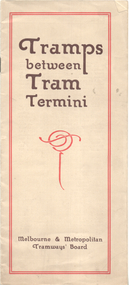
Booklet, Melbourne & Metropolitan Tramways Board (MMTB), "Tramps between tram termini", c1930
Booklet - promoting tram travel and walking trips or "tramps" between various tram terminus. Includes notes on the Board's services, its tourist tram with notes and fares on specific walks. Includes a map and some photos for each walk. 1 - Brighton Road to Hawthorn 2 - Burwood to Mont Albert 3 - Carnegie to Darling Road 4 - Whitehorse Road to East Kew 5 - Glen Iris to Darling Road 6 - Maribyrnong River to Mt Alexander Road 7 - Gardiner or Glen Iris to Burwood 8 - Wallen Road Bridge to Glenferrie Road 9 - Johnston St Bridge to Victoria Bridge At the time, some of these walks would have been through largely undeveloped land and parks.Demonstrates a promotion of the MMTB tram services and leisure activities.Booklet - 16 pages, two colours on light fawn paper, centre stapled.tramways, showgrounds, william st, mmtb -
 Melbourne Tram Museum
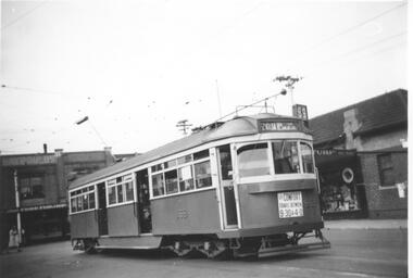
Photograph - Black & White Photograph/s, Lee A Ratten, mid 1940's
Black and white photograph of tramcar 869 in Glenferrie Road with Dash Canopy lighting. 1941 eleven SW6 class trams built by MMTB at Preston Workshops, numbers 866 to 876. Entered service 19 June 1941. Based at Malvern Depot c1948 to c1991. Advertisements in shop for Turf and Ardath. Sign on front of tram: "For comfort travel between 9:30 & 4:0" Tram has the destination of St Kilda Beach via Balaclava. Route number 69. Extensively damaged by fire in Church St at North Richmond terminus Tuesday, 14th November 2006. August 2014 transferred from Preston Workshops to Newport Workshops.trams, tramways, sw6 class, glenferrie rd, dash canopy lights, tram 869, route 69, kew -
 Melbourne Tram Museum
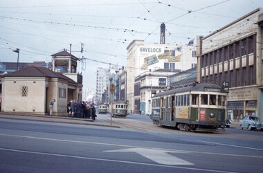
Slide - Set of 2, John Webster, 21/07/1959 12:00:00 AM
Set of two Colour slides, Kodak, white cardboard of trams of trams at the Victoria St / Swanston St shunt. 21-7-59. .1 - W2 340 showing East Malvern Darling road opposite the signal box followed by W2 showing route 4. Has a large number of men and school boys at the stop. In the view is a "No Entry" sign. In the background is the Ansett ANA building and a building advertising Havelock Tobacco. The tram has a Pimms No. 1 advert. .2 - W2's 550 (with a Castrol sign), 340 - as above and 358 (route 8, Toorak - Glenferrie Road) in the Victoria St shunting area. Has the Army hall behind the trams.Hand writing on rear in ink; "21-7-59 - KFB2 - TRACK - KEV - Swanston St near Victoria St Melbourne" "21-7-59 - KFB3 - TRACK - KEV - Trams in Victoria St Melbourne" Both slides have the speed and the f reading on the left hand side.trams, tramways, victoria st, swanston st, signal box, route 4, route 8, route 4d, east malvern, tram 550, tram 358, tram 340 -
 Ballarat Tramway Museum
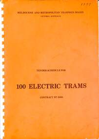
Document, Melbourne and Metropolitan Tramways Board (MMTB), "Tender Schedule for 100 Electric Trams Contract No. 3000", 1977
Compiled and published by the Melbourne and Metropolitan Tramways Board, closing Monday 10 May 1977. Details the conditions of tender, conditions of contract, notes, specifications, gives background information about Melbourne, dimensions, performance, drivers and conductors, trucks, wheels, brakes, electrical equipment, control panels and drawings. The drawings give a map of the system, typical city route, Glenferrie Road route (grade diagram), concrete track construction, min. radius curves, loading gauge, all-electric tram and mounting details for the trolley base, schedule of prices, tender form, form of contract, and schedule of information to be provided by the tenderer. Includes an Alphabetical Index. Includes a drawing for a single-ended version of the tramcar. Became the Z3 class following the addition of a rear or 3rd door. Yields information about the 1977 tender for 100 electric tramcars that became the Melbourne Z3 class tram.Comb bound (white plastic) specification or tender document, approx 180 pages, with glossy card orange covers, titled "Tender Schedule for Electric Trams" and "Contract 3000". "1977" on front cover in ink.tramways, tramcars, z3 class, specification, tenders, mmtb, melbourne, single ended tramcars -
 Kew Historical Society Inc
Slide - 'Reno', St John 's Parade, 1977
‘Reno’, stood on the east side of St John’s Parade. Its earliest recorded owner was the architect Samuel Cocking who lived there from c.1865 until his death in 1888. The original landholding was bordered by Cotham Road, Glenferrie Road, Wellington Street, and Charles Street. The southern portion of this land included a fine orchard, with many imported trees. The old summer house, at first in the orchard, was later removed to the house garden. The MMBW Detail Plan No.1576 (1904) shows the remaining portion of the original land holding, including a semi-circular pathway at the front, and garden features such as an aviary, a fountain and grotto, and a fernery. The garden including rare plants supplied by Baron Von Mueller, surrounds the cottage in a tangled frenzy. Despite a ‘local significance’ classification by the National Trust, the house was demolished in 1977.Rare photograph of an historically important weatherboard cottage in St John's Parade.Colour positive transparency (slide) of the verandah of 'Reno' in St John's Parade, Kew (demolished 1977). historic houses -- kew (vic.), reno -- st john's parade -- kew (vic.) -
 Kew Historical Society Inc
Slide - 'Reno', St John 's Parade, 1977
‘Reno’, stood on the east side of St John’s Parade. Its earliest recorded owner was the architect Samuel Cocking who lived there from c.1865 until his death in 1888. The original landholding was bordered by Cotham Road, Glenferrie Road, Wellington Street, and Charles Street. The southern portion of this land included a fine orchard, with many imported trees. The old summer house, at first in the orchard, was later removed to the house garden. The MMBW Detail Plan No.1576 (1904) shows the remaining portion of the original land holding, including a semi-circular pathway at the front, and garden features such as an aviary, a fountain and grotto, and a fernery. The garden including rare plants supplied by Baron Von Mueller, surrounds the cottage in a tangled frenzy. Despite a ‘local significance’ classification by the National Trust, the house was demolished in 1977.Rare photograph of an historically important weatherboard cottage in St John's Parade.Colour positive transparency (slide) of the a doorway of 'Reno' in St John's Parade, Kew (demolished 1977). historic houses -- kew (vic.), reno -- st john's parade -- kew (vic.) -
 Kew Historical Society Inc
Slide - 'Reno', St John 's Parade, 1977
‘Reno’, stood on the east side of St John’s Parade. Its earliest recorded owner was the architect Samuel Cocking who lived there from c.1865 until his death in 1888. The original landholding was bordered by Cotham Road, Glenferrie Road, Wellington Street, and Charles Street. The southern portion of this land included a fine orchard, with many imported trees. The old summer house, at first in the orchard, was later removed to the house garden. The MMBW Detail Plan No.1576 (1904) shows the remaining portion of the original land holding, including a semi-circular pathway at the front, and garden features such as an aviary, a fountain and grotto, and a fernery. The garden including rare plants supplied by Baron Von Mueller, surrounds the cottage in a tangled frenzy. Despite a ‘local significance’ classification by the National Trust, the house was demolished in 1977.Rare photograph of an historically important weatherboard cottage in St John's Parade.Colour positive transparency (slide) of the verandah of 'Reno' in St John's Parade, Kew (demolished 1977). historic houses -- kew (vic.), reno -- st john's parade -- kew (vic.) -
 Kew Historical Society Inc
Slide - Grotto of 'Reno', St John 's Parade, 1977
‘Reno’, stood on the east side of St John’s Parade. Its earliest recorded owner was the architect Samuel Cocking who lived there from c.1865 until his death in 1888. The original landholding was bordered by Cotham Road, Glenferrie Road, Wellington Street, and Charles Street. The southern portion of this land included a fine orchard, with many imported trees. The old summer house, at first in the orchard, was later removed to the house garden. The MMBW Detail Plan No.1576 (1904) shows the remaining portion of the original land holding, including a semi-circular pathway at the front, and garden features such as an aviary, a fountain and grotto, and a fernery. The garden including rare plants supplied by Baron Von Mueller, surrounds the cottage in a tangled frenzy. Despite a ‘local significance’ classification by the National Trust, the house was demolished in 1977.Rare photograph of an historically important weatherboard cottage in St John's Parade.Colour positive transparency (slide) of the grotto in the garden of 'Reno' in St John's Parade, Kew (demolished 1977). historic houses -- kew (vic.), reno -- st john's parade -- kew (vic.) -
 Kew Historical Society Inc
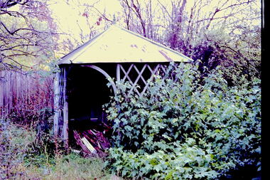
Slide - Former Summerhouse in the Garden of 'Reno', St John 's Parade, 1977
‘Reno’, stood on the east side of St John’s Parade. Its earliest recorded owner was the architect Samuel Cocking who lived there from c.1865 until his death in 1888. The original landholding was bordered by Cotham Road, Glenferrie Road, Wellington Street, and Charles Street. The southern portion of this land included a fine orchard, with many imported trees. The old summer house, at first in the orchard, was later removed to the house garden. The MMBW Detail Plan No.1576 (1904) shows the remaining portion of the original land holding, including a semi-circular pathway at the front, and garden features such as an aviary, a fountain and grotto, and a fernery. The garden including rare plants supplied by Baron Von Mueller, surrounds the cottage in a tangled frenzy. Despite a ‘local significance’ classification by the National Trust, the house was demolished in 1977.Rare photograph of an historically important weatherboard cottage in St John's Parade.Colour positive transparency (slide) of the former summerhouse in the garden of 'Reno' in St John's Parade, Kew (demolished 1977). historic houses -- kew (vic.), reno -- st john's parade -- kew (vic.) -
 Kew Historical Society Inc
Slide - 'Reno', St John 's Parade, 1977
‘Reno’, stood on the east side of St John’s Parade. Its earliest recorded owner was the architect Samuel Cocking who lived there from c.1865 until his death in 1888. The original landholding was bordered by Cotham Road, Glenferrie Road, Wellington Street, and Charles Street. The southern portion of this land included a fine orchard, with many imported trees. The old summer house, at first in the orchard, was later removed to the house garden. The MMBW Detail Plan No.1576 (1904) shows the remaining portion of the original land holding, including a semi-circular pathway at the front, and garden features such as an aviary, a fountain and grotto, and a fernery. The garden including rare plants supplied by Baron Von Mueller, surrounds the cottage in a tangled frenzy. Despite a ‘local significance’ classification by the National Trust, the house was demolished in 1977.Rare photograph of an historically important weatherboard cottage in St John's Parade.Colour positive transparency (slide) of the garden of 'Reno' in St John's Parade, Kew (demolished 1977). historic houses -- kew (vic.), reno -- st john's parade -- kew (vic.) -
 Kew Historical Society Inc
Slide - Former Summerhouse in the Garden of 'Reno', St John 's Parade, 1977
‘Reno’, stood on the east side of St John’s Parade. Its earliest recorded owner was the architect Samuel Cocking who lived there from c.1865 until his death in 1888. The original landholding was bordered by Cotham Road, Glenferrie Road, Wellington Street, and Charles Street. The southern portion of this land included a fine orchard, with many imported trees. The old summer house, at first in the orchard, was later removed to the house garden. The MMBW Detail Plan No.1576 (1904) shows the remaining portion of the original land holding, including a semi-circular pathway at the front, and garden features such as an aviary, a fountain and grotto, and a fernery. The garden including rare plants supplied by Baron Von Mueller, surrounds the cottage in a tangled frenzy. Despite a ‘local significance’ classification by the National Trust, the house was demolished in 1977.Rare photograph of an historically important weatherboard cottage in St John's Parade.Colour positive transparency (slide) of the former summerhouse in the garden of 'Reno' in St John's Parade, Kew (demolished 1977). historic houses -- kew (vic.), reno -- st john's parade -- kew (vic.) -
 Kew Historical Society Inc
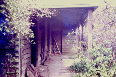
Photograph - 'Reno', 10 St John's Parade, John T Collins, 1977
‘Reno’, stood on the east side of St John’s Parade. Its earliest recorded owner was the architect Samuel Cocking who lived there from c.1865 until his death in 1888. The original landholding was bordered by Cotham Road, Glenferrie Road, Wellington Street, and Charles Street. The southern portion of this land included a fine orchard, with many imported trees. The old summer house, at first in the orchard, was later removed to the house garden. The MMBW Detail Plan No.1576 (1904) shows the remaining portion of the original land holding, including a semi-circular pathway at the front, and garden features such as an aviary, a fountain and grotto, and a fernery. The garden including rare plants supplied by Baron Von Mueller, surrounds the cottage in a tangled frenzy. Despite a ‘local significance’ classification by the National Trust, the house was demolished in 1977.Partial view, north side of the weatherboard cottage in St John's Parade, Kew, known as 'Reno' (demolished 1977). Architectural elements revealed in this photo by John T Collins include: two wing, hip roof construction; external buildings at angles to main wing; corrugated iron roofing [over shingles]; brick chimney external to building; unvarnished/unpainted external weatherboards. General dilapidated condition. "Kew 'Reno' 10 St Johns Pde / John Collins, 11 Anderson Road, Hawthorn East, 3123, Film 35B Exposure 27"reno - st john's parade -- kew (vic.), john t collins -
 Kew Historical Society Inc
Photograph - 'Reno', 10 St John's Parade, John T Collins, 1977
‘Reno’, stood on the east side of St John’s Parade. Its earliest recorded owner was the architect Samuel Cocking who lived there from c.1865 until his death in 1888. The original landholding was bordered by Cotham Road, Glenferrie Road, Wellington Street, and Charles Street. The southern portion of this land included a fine orchard, with many imported trees. The old summer house, at first in the orchard, was later removed to the house garden. The MMBW Detail Plan No.1576 (1904) shows the remaining portion of the original land holding, including a semi-circular pathway at the front, and garden features such as an aviary, a fountain and grotto, and a fernery. The garden including rare plants supplied by Baron Von Mueller, surrounds the cottage in a tangled frenzy. Despite a ‘local significance’ classification by the National Trust, the house was demolished in 1977.Partial view, side of the weatherboard cottage in St John's Parade, Kew, known as 'Reno' (demolished 1977). Architectural elements revealed in this photo by John T Collins include: hip roof construction; corrugated iron roofing [over shingles]; unvarnished/unpainted external weatherboards; Externally opening 1860s-style casement window. General dilapidated condition. "Kew 'Reno' 10 St Johns Pde / John Collins, 11 Anderson Road, Hawthorn East, 3123, Film 35B Exposure 26"reno - st john's parade -- kew (vic.), john t collins -
 Kew Historical Society Inc
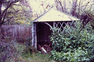
Photograph - 'Reno', 10 St John's Parade, John T Collins, 1977
‘Reno’, stood on the east side of St John’s Parade. Its earliest recorded owner was the architect Samuel Cocking who lived there from c.1865 until his death in 1888. The original landholding was bordered by Cotham Road, Glenferrie Road, Wellington Street, and Charles Street. The southern portion of this land included a fine orchard, with many imported trees. The old summer house, at first in the orchard, was later removed to the house garden. The MMBW Detail Plan No.1576 (1904) shows the remaining portion of the original land holding, including a semi-circular pathway at the front, and garden features such as an aviary, a fountain and grotto, and a fernery. The garden including rare plants supplied by Baron Von Mueller, surrounds the cottage in a tangled frenzy. Despite a ‘local significance’ classification by the National Trust, the house was demolished in 1977.Side of the original, relocated summer house of 'Reno' at 10 St John's Parade, Kew, (demolished 1977). Architectural elements revealed in this photo by John T Collins include: four-sided construction; trellis and weatherboard walls; corrugated iron roofing. Re-use as woodshed. General dilapidated condition. "Kew 'Reno' 10 St Johns Pde / John Collins, 11 Anderson Road, Hawthorn East, 3123, Film 35B Exposure 24"reno - st john's parade -- kew (vic.), john t collins -
 Kew Historical Society Inc
Plan, Melbourne & Metropolitan Board of Works : Borough of Kew : Detail Plan No.1574, 1905
The Melbourne and Metropolitan Board of Works (MMBW) plans were produced from the 1890s to the 1950s. They were crucial to the design and development of Melbourne's sewerage and drainage system. The plans, at a scale of 40 feet to 1 inch (1:480), provide a detailed historical record of Melbourne streetscapes and environmental features. Each plan covers one or two street blocks (roughly six streets), showing details of buildings, including garden layouts and ownership boundaries, and features such as laneways, drains, bridges, parks, municipal boundaries and other prominent landmarks as they existed at the time each plan was produced. (Source: State Library of Victoria)This plan forms part of a large group of MMBW plans and maps that was donated to the Society by the Mr Poulter, City Engineer of the City of Kew in 1989. Within this collection, thirty-five hand-coloured plans, backed with linen, are of statewide significance as they include annotations that provide details of construction materials used in buildings in the first decade of the 20th century as well as additional information about land ownership and usage. The copies in the Public Record Office Victoria and the State Library of Victoria are monochrome versions which do not denote building materials so that the maps in this collection are invaluable and unique tools for researchers and heritage consultants. A number of the plans are not held in the collection of the State Library of Victoria so they have the additional attribute of rarity.Original survey plan, issued by the MMBW to a contractor with responsibility for constructing sewers in the area identified on the plan within the Borough of Kew. The plan was at some stage hand-coloured, possibly by the contractor, but more likely by officers working in the Engineering Department of the Borough and later Town, then City of Kew. The hand-coloured sections of buildings on the plan were used to denote masonry or brick constructions (pink), weatherboard constructions (yellow), and public buildings (grey). This plan shows several very large houses, particularly along Glenferrie Road, and the area now occupied by Ruyton Girls’ School. ‘Tarring’ (incorrectly spelled here as ‘Karring’) was built for Henry Henty in 1872, on part of his original allotment of 20 acres, and ‘Mount View’, which retains its original building and the fountain in the front garden, is part of Ruyton’s Junior School. The most significant change to Tarring and its grounds since 1903, involve the removal of a number of the outbuildings, including a Burmese temple, bought by Henty from the Burmese Exhibit at the Great Exhibition of 1880. It is shown on the plan as a summerhouse. The two-storey mansion, on the corner of Glenferrie Road and Wellington Street, was built in 1891 by leading architect Alfred White as his own home. Having an initial N.A.V. of £160, the house was purchased by a warehouseman Henry Lister, by 1900, when the N.A.V. was recorded at £111. By the turn of the century the house was known as ‘Comaques’. By contrast, much smaller houses are shown in Scott and Byron Streets, including a tiny Mission Hall in Byron Street, which belonged to the Anglican Church from at least 1903 to 1917.melbourne and metropolitan board of works, detail plans, maps - borough of kew, mmbw 1574, cartography -
 Kew Historical Society Inc
Legal record - The Indenture, Crown Portion 86, otherwise known as 'The Morgan Deed', 1852 (and later)
This indenture once formed part of the City of Kew's Municipal Collection. Cr. W.D. Vaughan in his history 'Kew's Civic Century' (1960) records on page 194 that: "The original deed of conveyance of the land being all of Crown Portion 86, Kew, purchased by John Quick, James Venn Morgan, Samuel Derrick and William Derrick was presented by the Historical Society of Victoria on behalf of Mrs Fryer, a daughter of the later J.V. Morgan, to the [Kew] Council on August 5, 1941. Crown Portion 86, comprised all the land between Cotham Road and High Street to an alignment opposite the east boundary of Glenferrie Road. On it the first residential house was built by Mr. J.V. Morgan in 1852." Following the donation, the Indenture was surrounded by other original related text and explanatory notes and framed. The resulting framed documents are the largest framed objects in the collection.The Indenture and the accompanying contextual documents are some of the most historically significant manuscripts to have survived since the settlement of Kew in the 1850s. They provide a link to Kew's most famous pioneering families.Framed 1952 Indenture recording the sale of land in Kew to pioneering Kew families.james venn morgan, john quick, william derrick, samuel derrick, kew (vic) - history, kew (vic) - pioneers, samuel watts, kew (vic.) — municipal collection -
 Kew Historical Society Inc
Plan - Subdivision : Cotham and Glenferrie Roads, J R Mathers & McMillan
The Kew Historical Society's map collection includes a substantial number of real estate subdivision plans, mainly of Kew but also of surrounding suburbs in Melbourne. Most of the subdivision plans date from the 1920s and 1930s when the districts old homes and local farmland were being split up to accommodate residential growth in the postwar period. These early plans were assembled by a local firm, Jas R Mather & McMillan, which had an office in Cotham Road. Many of the plans, and sometimes photos, were annotated by the agents.Subdivision plans are historically important documents used as evidence for the growth of suburbs in Australia. They frequently provide information about when the land was sold as well as evidence relating to surveyors and real estate and financial agents. The numerous subdivision plans in the Kew Historical Society's collection represent working documents, ranging from the initial sketches made in planning a subdivision to printed plans on which auctioneers or agents listed the prices for which individual lots were sold. In a number of cases, the reverse of a subdivision plan in the collection includes a photograph of a house that was also for sale by the agent. These photographs provide significant heritage information relating house design and decoration, fencing and household gardens.The photograph may also be aesthetically significant depending on the importance of the photographic atelier.An undated and untitled hand-drawn and coloured subdivision plan detailing the boundaries of a number of irregular allotments bordering Cotham Road, Glenferrie Road and Stirling Avenue (now Stirling Street). The plan predates the actual subdivision that led to the creation of the eight commercial properties occupying 118-132 Cotham Road. The plan may represent an old subdivision that was further subdivided at a later date, or it may be a subdivision that never eventuated. On MMBW Detail Plan 1575 (1903), the area represented by the proposed subdivision was residential rather than commercial. The irregularity of lots is also apparent in the MMBW Plan. The largest of the unnumbered blocks on the hand-drawn subdivision plan may relate to the boundaries of the nineteenth century mansion identified as ‘Kelso’ on the MMBW Plan.subdivision plans - kew, cotham road - kew,, glenferrie road - kew , stirling avenue street - kew -
 Melbourne Tram Museum
Pamphlet, Yarra Trams, "New Year's Eve 2013", 2013 and 2016
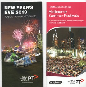
Pamphlets - set of 2 printed in full colour on paper folded to DL size. .1 - "New Year's Eve 2013" - 8 fold, 2 half foldout - with a map showing fire works sites, locations, tram alterations, and how public transport could be used in the city. .2 - "Tram service during Melbourne Summer Festivals" - 4 fold, - issued 1/2016, detailing timetable alternations and service changes for Feb. and March - includes events - St Kilda Festival, White Night, Glenferrie Road Festival, Sydney Road festival and Moomba Parade. Has a calendar and maps. Also lists other major events and network upgrade and tram improvement works. Issued by Yarra Trams and the PTV.trams, tramways, events, melbourne, moomba, glenferrie rd, sydney rd, st kilda -
 Melbourne Tram Museum
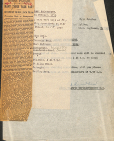
Document - Memorandum, Melbourne & Metropolitan Tramways Board (MMTB), "Back to Horse" Procession, 24/10/1934 12:00:00 AM
Memorandum - one typed sheets (8"x10.5") - titled "Back to Horse" Procession. - Saturday 27 October, 1934 from DJ Davidson, District Traffic Superintendent S.S. Note paper pinned to front with inscription: "Back to Horse" Procession. - Saturday 27 October, 1934" Typed details of tram shunting at City Rd and Flinders St. "Pencil alt 28/9/35 1935" written in black pencil. Several pencil crosses next to times. Camberwell and Glenferrie Rd crossed out and rewritten in black pencil. One newspaper clipping titled "Horse Parade - Many Types take Part - Interest in Bullock Team - Procession Ends at Showground". "Argus" & "29/10/34" written in red ink.Numerous notes written in black pencil across memostrams, tramways, instructions, events, showgrounds, city rd, flinders st -
 Ballarat Tramway Museum
Document - Specification, Melbourne and Metropolitan Tramways Board (MMTB), "Tender Schedule for All-Electric Trams", 1972
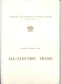
Comb bound (white plastic) specification document, approx. 70 pages, with glossy card covers, titled "Tender Schedule for All-Electric Trams", published by the Melbourne and Metropolitan Tramways Board, closing 2 Oct. 1972. Details the conditions of tender, conditions of contract, notes, specification, gives background information about Melbourne, dimensions, performance, drivers and conductors, trucks, wheels, brakes, electrical equipment, control panels and drawings. The drawings give a map of the system, typical city route, Glenferrie Road route (grade diagram), concrete track construction, min. radius curves, loading gauge, all-electric tram and mounting details for the trolley base, schedule of prices, tender form, form of contract, schedule of information to be provided by the tenderer.trams, tramways, specification, tenders, z class trams, mmtb, melbourne -
 Kew Historical Society Inc
Photograph - 'Mount Eri', 9 Highbury Grove, 1919
Subdivision plans are historically important documents used as evidence of the growth of suburbs in Australia. They frequently provide information about when the land was sold on which a built structure was subsequently constructed as well as evidence relating to surveyors and real estate and financial agents. The numerous subdivision plans in the Kew Historical Society's collection represent working documents, ranging from the initial sketches made in planning a subdivision to printed plans on which auctioneers or agents listed the prices for which individual lots were sold. In a number of cases, the reverse of a subdivision plan in the collection includes a photograph of a house that was also for sale by the agent. These photographs provide significant heritage information relating house design and decoration, fencing and household gardens.A photograph of Mount Eri, 9 Highbury Grove, an 11-room house for sale near the junction of Cotham and Glenferrie Roads. The substantial red brick, slate-roofed house and its location are not identified in the photograph, although the extent of the house is noted. It was described then as ‘well situated’ and close to 3 trams. Mathers, a financial agent in Cotham Road, placed advertisements about the sale of the property in The Argus in May and June 1919. The advertisement additionally refers to a billiard room and asserts that the house has every modern convenience. An annotation on the plan indicates that the house, with tennis court, was sold for £1960. Following extensive research, the house has now been conclusively identified, albeit extended and rendered. The house was originally built in the 19th century as a school and for much of the 20th century was used as a venue for receptions. -
 Melbourne Tram Museum
Newspaper, Head of River Boat races, May. 1934
Head of River Boat races Newspaper clipping and table card for tram scheduling for Head of River Boat Races, Thursday 17 May & Friday 18 May 1934: 1 - Newspaper clipping: outlining daily program of races. 490H x 60W, poor condition, torn and folded 2 - Set of 3 pages of handwritten table cards for Head of River Boat Races. Loading Checks on all routes taken at St Kilda and City Rds, Elsternwick, St Kilda Beach, Toorak, South Melbourne & St Kilda Beaches, east Malvern, Glen Iris, Camberwell, east Malvern @ St Kilda Junction. Loading Checks of Batman Avenue Cars, Glenferrie Rd, Swan & Church Sts, Prahran Cars Swan & Church Ststrams, tramways, instructions, events -
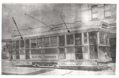 Melbourne Tram Museum
Photograph - Set of 2 Black & White Photograph/s, LWR, c1920
Set of two copy photographs. Photograph, Black and White of MMTB trams. Both photographs have arrows drawn on them pointing to the top of the cross bench seating windows where the unique drop bar latches appear. These were apparently unique to this class of tram. .1 - K class No. 100 - probably about 1920. Note the twin trolley poles on this single truck car when new. This car also apparently entered service with air brakes. .2 - K class No. 97 - probably about 1920. Photo taken in Glenferrie Road Malvern at High Street. Keith has noted on both prints the in-service dates, though the MMTB had taken over around that time, both painted with "Municipal Tramways" lettering.In ink on the rear: .1 -" Melbourne K97 - probably about 1920 - In service 3.3.1920, with "Municipal Tramways" lettering though M&MTB formed 1.11.1919. No magnetic track brakes." .2 - "as above except for K100 and in service date of 25.12.1919. Has KSK number LWR8 and LWR9 respectively into right hand corner.trams, tramways, k class, pmtt, livery, tram 97, tram 100, trolley poles, mmtb, malvern, glenferrie road