Showing 1363 items matching "heritage council"
-
 Eltham District Historical Society Inc
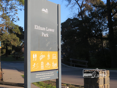
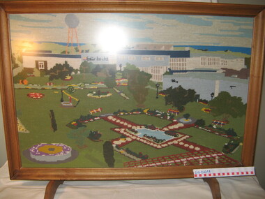
Photograph, Liz Pidgeon, Heritage Excursion; Eltham Lower Park Walk and Talk, 1 July 2017, 1 July 2017
Eltham Lower Park sign with Council logo at the entrance of the Park. Newsletter No., 234, June 2017 Heritage Excursion - Saturday 1st July - Eltham Lower Park - Walk and Talk Eltham Lower Park has played an important part in the history of our area since the early days of European settlement when it was used by local residents as an informal racecourse. Prior to that its location at the junction of the Diamond Creek and the Yarra River made it an important meeting place for the Wurundjeri people. The park combines formal elements and sporting facilities with remnant bushland that is of environmental significance. It is home to sporting and horse riding clubs, popular play spaces and the Diamond Valley Miniature Railway, which attracts large numbers of visitors. The park will be the venue for our July excursion which will comprise a walk of about 3.5 km around the park and adjacent areas. Along the way we will discuss the history and natural history of the area. The path along the creek and the river provides a pleasant and scenic walk. This walk on Saturday 1st July is about 3.5 km in length and will take 2 to 2.5 hours. It will start at 2pm at the Main Road car park at the front of the park. (Melway ref 21 H 10). Born Digitalelection day, heritage excursion, activities, eltham district historical society, eltham lower park, sign -
 Eltham District Historical Society Inc
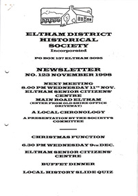
Newsletter, Newsletter, No. 123 November 1998
Contents: • Next meeting, A Local Chronology; A presentation by the Society’s Committee • November Meeting • Christmas Function • Banyule Council Matters • Nillumbik Council • President’s Report • Mud Brick Heritage Excursion – and the Future • Other Brief Matters The Shire of Eltham Historical Society was formed in October 1967. The first newsletter of the Society was issued May 1978 and has been published continuously ever since on a bi-monthly basis. With the cessation of the Shire of Eltham in late 1994, the Society's name was revised to Eltham District Historical Society and this name first appeared with issue No. 103, July 1995. The collection of the Society's newsletters provides a valuable resource on the history of the Society's activities, office bearers and committee members, guest speakers and subjects of historical interest pertinent to the former Shire of Eltham and the Eltham District.A4 photocopied newsletter distributed to membersnewsletter, eltham district historical society, shire of eltham historical society -
 Eltham District Historical Society Inc
Photograph, Shire of Nillumbik World War One Memorials tour, 10 August 2016, 10 August 2016
As part of a program to acknowledge the Anzac Centenary Nillumbik Shire Council partnered with Yarra Plenty Regional Library to provide a bus tour with commentary of local sites of significance. These included Eltham township, the Shire of Eltham War Memorial at Kangaroo Ground, Christmas Hills, Hurstbridge memorial recreation park and finshed at Eltham Library to view the Writing the War exhibtion at Eltham Library Community Gallery. Display - The Roads through Christmas Hills in the Christmas Hills Mechanics InstituteBorn Digitalchristmas hills mechanics institute, heritage display -
 Eltham District Historical Society Inc
Photograph, Shire of Nillumbik World War One Memorials tour, 10 August 2016, 10 August 2016
s part of a program to acknowledge the Anzac Centenary Nillumbik Shire Council partnered with Yarra Plenty Regional Library to provide a bus tour with commentary of local sites of significance. These included Eltham township, the Shire of Eltham War Memorial at Kangaroo Ground, Christmas Hills, Hurstbridge memorial recreation park and finshed at Eltham Library to view the Writing the War exhibtion at Eltham Library Community Gallery. Born Digitalchristmas hills mechanics institute, heritage display, visitors, display cabinet -
 Eltham District Historical Society Inc
Photograph, Kangaroo Ground War Memorial Park: Photo display, 10 August 2016
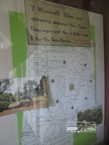
Display in glass cabinet at the base of the stairs at the tower at Kangaroo Ground. 7 windmill palms are growing around the tower. They represent 6 states and 1 for the Territories with map and photo. As part of a program to acknowledge the Anzac Centenary Nillumbik Shire Council partnered with Yarra Plenty Regional Library to provide a bus tour with commentary of local sites of significance. These included Eltham township, the Shire of Eltham War Memorial at Kangaroo Ground, Christmas Hills, Hurstbridge memorial recreation park and finished at Eltham Library to view the Writing the War exhibtion at Eltham Library Community Gallery. Born Digitalworld war 1, war memorials, shire of nillumbik, heritage display, shire of eltham war memorial, kangaroo ground -
 Eltham District Historical Society Inc
Photograph, Liz Pidgeon, Kangaroo Ground War Memorial Park: Photo display, 10 August 2016
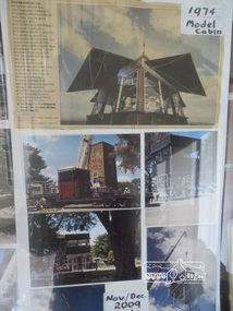
Glass cabinet at the base of the stairs at the tower showing colour photographs depicitng the installation of the CFA tower in November/ December 2009. As part of a program to acknowledge the Anzac Centenary Nillumbik Shire Council partnered with Yarra Plenty Regional Library to provide a bus tour with commentary of local sites of significance. These included Eltham township, the Shire of Eltham War Memorial at Kangaroo Ground, Christmas Hills, Hurstbridge memorial recreation park and finished at Eltham Library to view the Writing the War exhibtion at Eltham Library Community Gallery.Born Digitalworld war 1, war memorials, shire of nillumbik, kangaroo ground, heritage display, shire of eltham war memorial, cfa -
 Eltham District Historical Society Inc
Photograph, Liz Pidgeon, Kangaroo Ground War Memorial Park: Photo display, 10 August 2016
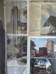
Glass cabinet at the base of the stairs at the tower showing colour photographs depicitng the installation of the CFA tower in November/ December 2009. As part of a program to acknowledge the Anzac Centenary Nillumbik Shire Council partnered with Yarra Plenty Regional Library to provide a bus tour with commentary of local sites of significance. These included Eltham township, the Shire of Eltham War Memorial at Kangaroo Ground, Christmas Hills, Hurstbridge memorial recreation park and finished at Eltham Library to view the Writing the War exhibtion at Eltham Library Community Gallery. Born Digitalworld war 1, war memorials, shire of nillumbik, kangaroo ground, heritage display, shire of eltham war memorial, cfa -
 Eltham District Historical Society Inc
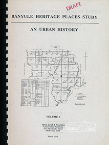
Book, Banyule City Council, Banyule Heritage Places Study - An Urban History, Volume 1 prepared by Allom Lovell & Associates, 1998 March
Describes the broad patterns of development across Banyule in the post-European contact period, 92 p, 30 cmbanyule history, greensborough history, montmorency history, heidelberg history, ivanhoe history -
 Eltham District Historical Society Inc
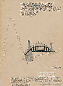
Book, Graem Butler, Heidelberg Conservation Study, Part 1 Heidelberg Historic Buildings and Areas Assessment by Graeme Butler, November 1985
Historic Buildings and Areas Assessment by Graeme Butler. Part 1 of award winning study carried out in 1982 in collaboration with a community advisory committee to Heidelberg City Council. Pioneering identification of a broad range of heritage assets varying from buildings, gravestones, farm structures, landscape areas, mileposts, divided street construction, in a time when buildings only were assessed in municipal studies.2 v. : ill., maps ; 29 cm.significant buildings heidelberg victoria, history development of heidelberg victoria, man-made landscape heidelberg victoria, significant precincts heidelberg victoria, conservation study, graeme butler -
 Eltham District Historical Society Inc
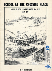
Book, School at the crossing place : Lower Plenty Primary School no. 1295, 1874-1974 / W.F. Henderson, 1974c
23 pages including information on inside covers. Text with black and white illustrations and photographs and map. Contents: Crossing Place Need for a school Residence for the teacher Closure A View of Lower Plenty 1918 Moving day at the Village The Golf Club Depression 1931 Vandals Electricity Grass Fires Cows at School Mothers' Club Women's liberation 1950's Lower Plenty after 1945 Swimming Pool - drowned dreams Long Grass - snakes - meadow hay - Fire Brigade The Royal Visit 1954 School Band Community Centre Our School Hall Trees and Gardens The Library Education 1874-1974 A Teacher's View The Second generation - children of ex-pupils (photo with names) The Third generation - Grandchildren of ex-pupils (photo with names) Head Teachers (list with dates) The Staff 1974 (photo with names) The sketch on the cover shows the Lower Plenty Bridge, toll house and the Plenty Bridge hotel, both no longer there. The bridge is listed in the Banyule Heritage Study and has recently been restored by Banyule Council as a pedestrian bridge - NL 137 March 2001 Paperback; [24] p. : ill. ; 25 cm.lower plenty, state school no. 1295, lower plenty primary school -
 Eltham District Historical Society Inc
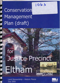
Book, Conservation Management Plan - Eltham Justice Precinct (January 2006) prepared for Nillumbik Shire
Guidance on the heritage issues in the management of the court house and former police buildings of the early justice precinct at Eltham.68 p, 30 cm. Also draft copy - Conservation Management Plan (draft) for Justice Precinct Eltham (July 2005) prepared for Nillumbik Shire 2006 This copy is the property of the Eltham District Historical Society Inc.eltham justice precinct, justice precinct eltham -
 Eltham District Historical Society Inc
Book, Ivar Nelsen, Conservation Management Plan (draft) for Justice Precinct Eltham (July 2005) prepared for Nillumbik Shire, 2006
Draft for report on guidance on the heritage issues in the management of the court house and former police buildings of the early justice precinct at Eltham.39 p, 30 cm.Harry Gilham E.D.H.S. Inc.eltham justice precinct, justice precinct eltham -
 Eltham District Historical Society Inc
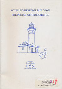
Book, Eric J. Martin, Access to heritage buildings for people with disabilities / prepared by Eric J. Martin, 1997c
Paperback; 64 p. : ill. ; 30 cm.ISBN 0646349783buildings -
 Warrnambool and District Historical Society Inc.
Textile - Fire screen, Tapestry, Post 1967
David Fletcher Jones (1895-1977) was a travelling hawker who opened a business in Liebig Street, Warrnambool in 1924. In 1931 he opened The Man's Shop at the corner of Liebig Street and Koroit Street. He sold suits and overcoats tailored in the work rooms upstairs. In 1948 his factory known as Pleasant Hill was opened in Flaxman Street in Warrnambool, the site of an old quarry. In 1951 the company Fletcher Jones and Staff was formed with the staff owning 51% of the shares, By the 1970s Fletcher Jones and Staff had become one of the largest clothing companies in Australia with 55 shops and 3000 employees. In 1992 the Warrnambool City Council bought the factory and gardens with the site now a tourist attraction. Although the name is retained today for trading purposes the original Fletcher Jones company has been dissolved. The screen is a representation of the Fletcher Jones factory post 1967. It a wool tapestry by Martin Prider who was a painter and caretaker what the Fletcher Jones factory. He lived in one of the Fletcher Jones cottages on site. (Robin Boyd Age Small Homes Scheme, today Heritage listed.)This is an interesting memento of the Fletcher Jones company and the factory. It was done by a local resident and features the famous Fletcher Jones gardensTapestry fire screen in a rectangular light timber frame depicting the Fletcher Jones Factory Gardens. The screen has two timber feet, non relective glass and appears to be a wool tapestry. The image of the gardens is after 1967 as the silver ball is included and that was erected in 1967. Nilfletcher jones company and warrnambool factory, pleasant hill warrnambool, martin prider, fletcher jones, tapestry of fletcher jones factory -
 Warrnambool and District Historical Society Inc.
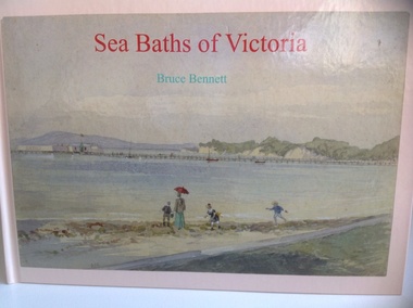
Book, Sea Baths of Victoria, 2013
History of sea baths in Victoria.Hardback, landscape book with watercolour painting of Sea baths at Sorrento looking east by AC Clarke on the front. Also the title in red and author Bruce Bennett in aqua. The spine has the title and author as above. On the back cover are six reproductions of sea baths and synopsis of the book. 152 pages of white, gloss paper, acknowledgements, contents, preface, 5pages of References and a 2 page Index. The end papers are of white paper. non-fictionHistory of sea baths in Victoria.sea water baths, victoria, bruce bennett, warrnambool, windmill, 1890, swimming, closed 1960s, bathing boxes, poster, warrnambool baths company, 1877 -
 Warrnambool and District Historical Society Inc.
Book, Warrnambool Botanic Garden Masterplan, February 1995
This Warrnambool Botanic Gardens Study and Report was funded by the National Estate Grants Program of the Australian Heritage Commission and the City of Warrnambool. It was monitored in progress by a Steering Committee consisting of representatives of the Botanic and Public Gardens Advisory Committee, the Warrnambool City Council, Friends of the Warrnambool Botanic Gardens and National Estate Grants Program representatives and community representatives. The Warrnambool Botanic Gardens were first sited close to the Hopkins River in 1859. In 1869 the gardens were relocated to the present day location in Botanic Road. This plan is of some importance as it gives an overview of the history and current condition in 1995 of the Warrnambool Botanic Gardens and draws up a plan for its future development. It is useful for research and for consideration by the City Council today of policy making and further development of the gardens. This is a publication containing a master plan for the Warrnambool Botanic Gardens. It has a section on acknowledgements, a summary, eight chapters, and 14 appendices. The pages are bound with plastic rings, the front cover is plasticized with an aerial photograph of the Botanic Gardens and surrounds and the back cover is lightweight cardboard. The pages contain printed material, fold out maps, sketches and diagrams and many photocopied photographs.Front Cover: City of Warrnambool, Warrnambool Botanic Gardens, Conservation and Development Plan, Jill Orr-Young, Patrick Mallon, SF Consultants Pty Ltd, February 1995. warrnambool botanic gardens, warrnambool -
 Eltham District Historical Society Inc
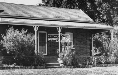
Negative - Photograph, Leader Publishing Co, Wingrove Cottage, c.1970
Wingrove Cottage is historically significant for its long association with Charles Wingrove, a prominent figure in Victorian local government, as secretary to the Eltham District Road Board and Shire Council from 1858 to 1904, and Shire Engineer and Secretary to the Heidelberg Road Board. The cottage was also used as the office of the Eltham District Road Board and Council for many years . One of the Shire's oldest dwellings, and one of the few surviving 19th century buildings associated with early Eltham and located in the original Eltham Village Reserve. Wingrove Cottage is considered historically significant to the Shire of Nillumbik and is registered on the Victorian Heritage Database. This photo forms part of a collection of photographs gathered by the Shire of Eltham for their centenary project book,"Pioneers and Painters: 100 years of the Shire of Eltham" by Alan Marshall (1971). The collection of over 500 images is held in partnership between Eltham District Historical Society and Yarra Plenty Regional Library (Eltham Library) and is now formally known as the 'The Shire of Eltham Pioneers Photograph Collection.' It is significant in being the first community sourced collection representing the places and people of the Shire's first one hundred years.Digital image 4 x 5 inch B&W Neg Print 20 x 25 cmsepp, shire of eltham pioneers photograph collection, eltham, wingrove cottage, charles wingrove, houses -
 Eltham District Historical Society Inc
Photograph, Tom Prior, Police Station and Residence, Maria Street, Eltham, c.1900
Situated near the top of what was known as 'Policeman's Hill' according to Miss Ivy Reynolds, neice of the photographer, Tom Prior. From the left, Eltham Court House, Police Residence and Police station on Main Road and corner of Brougham Street. These buildings formed part of Little Eltham and still stand (without the front fence) today though the Police Station was demolished in 1986 due to termite damage. A replica was built circa 1989. The institutions of law and order in Colonial Victoria included the police, courts and prisons. The 1852 report of the Snodgrass Select Committee appointed to "identify the policing needs of the colony” noted there existed seven independent police forces that did not co-operate or regularly communicate. Following the committee's report all these police entities were merged into the Victoria Police, founded on 8 January 1853, to implement law and order responsibilities throughout the Colony of Victoria. The Eltham Courthouse (1860) and adjacent Police Residence (1859) formed a justice precinct established in the immediate aftermath of the 1852 police inquiry and the effects of the gold rush. The physical presence of these buildings, in the centre of the early Eltham township, defined centralised control over law and order. In the early days the Police Constable in charge would conduct his duties travelling around the district by horse; a stable was located at the rear of the residence. At times the horse would be grazed on the paddocks across the road. Horseshoes were forged by the blacksmith beside the Courthouse on the high side of “Policeman’s Hill”. Along with the stable, there was a two-cell bluestone lockup where prisoners were held awaiting trial in the adjacent Courthouse. Their meals were usually provided by the policeman’s wife or from the hotel just up the road. With the arrival of the railway in 1902 the town centre gradually shifted towards the railway station. The Police Station and operations were moved into the town centre in 1961 to a renovated house in Pryor Street, which was later replaced by the current Police Station. From 1961-1981 the residence was occupied by the Vermin and Noxious Weeds Destruction Section of the Department of Crown Lands and Survey. Prior to August 1967 the former Police Station was dragged to the rear of Police Residence to make way for the construction of a driveway and access from Main Road. The building was placed on the site of a former Scullery and modified for Lands Department use. In 1981 the Shire of Eltham took over management of the former Police Residence in Eltham. It remained unoccupied for a period whilst its future was discussed in Council. It was then used for a community job creation scheme until 1985. In 1985 the Shire of Eltham Parks and Environment occupied the residence. Council improved the driveway but later added a second rear access from Brougham Street due to the dangerous nature of the Main Road entrance. Additionally, a rear toilet facility between the Police Residence and the relocated former Police Station, which was doubling up as a lunchroom. Council also commenced discussions to re-establish a replica Police Station. Around November 1986 the former Police Station was demolished; believed to have been suffering termite damage. About 1989, after some years of discussion, a replica Police Station was built, based on photographs, to act as a lunchroom and meeting room for the Parks and Environment staff and volunteers doing community service. In 1996 Eltham District Historical Society held discussions with Nillumbik Shire Council commissioners throughout the year regarding a home for the Society. A proposal was put forward by the Society in October to occupy the former Police Residence. In March 1997 Eltham District Historical Society gained access to former Police Residence and on July 12, 1998, moved into its Local History Centre. In July 2018, Eltham District Historical Society gained access to the replica Police Station (which had been used as a music library and storage for the Eltham Concert Band) for use as part of regular heritage tours for schools and community-based groups.This photo forms part of a collection of photographs gathered by the Shire of Eltham for their centenary project book,"Pioneers and Painters: 100 years of the Shire of Eltham" by Alan Marshall (1971). The collection of over 500 images is held in partnership between Eltham District Historical Society and Yarra Plenty Regional Library (Eltham Library) and is now formally known as 'The Shire of Eltham Pioneers Photograph Collection.' It is significant in being the first community sourced collection representing the places and people of the Shire's first one hundred years. The Reynolds family were early settlers in Research. The Reynolds/ Prior collection of photographs were taken by Tom Prior, the maternal uncle of Ivy Reynolds, around 1900 and the 60 photos in the album give a fine overview of many of the landmarks of Research and Eltham over 100 years ago. lvy lived in the family home for many years at 106 Thompson Cres Research. Ivy's father, Ernst Richard Reynolds and grandfather, Richard Reynolds, lived at the same address. Ivy's father Richard worked for Mr. Trail on his property in Research. Reynolds Road is named after the family. Mr Tom Prior (wife Eva) worked at the Melbourne zoo. He was very innovative and made his own camera, using the black cloth hood to exclude the light. The photographs are a reminder of the rural nature of Research and Eltham and its rich heritage.Digital imagechildren, court house, courthouse, eltham, eltham district historical society, eltham justice precinct, little eltham, local history centre, main road, police residence, police station, reynolds prior collection, sepp, shadow, shire of eltham pioneers photograph collection -
 Eltham District Historical Society Inc
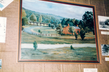
Photograph, Peter Bassett-Smith, Beautiful Eltham, Joh Ebeli, 1988
Former Shire of Eltham Art Collection now Nillumbik Shire Council Art Collection, 'Beautiful Eltham' by Joh Ebeli showing Shillinglaw Cottage and Railway Trestle Bridge. Bicentennial/Heritage Week Display, "The Eltham Tradition", Eltham Shire Office, 17-22 April 1988 Colour photographactivities, eltham shire office, heritage display, heritage week, beautiful eltham, joh ebeli, shillinglaw cottage, trestle bridge -
 Ringwood and District Historical Society
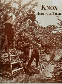
Book, Knox Heritage Trail Book. By Glen Turnbull, Knox Historical Society 2002, 2002
A Federation Fund Project 1901-2001 Commonwealth Government Initiative. Contents- brief history of the district, Knox Heritage Trust Sign Locations. Shire of Ferntree Gully Council 1901. History of Federal Electorates. History of the Knox Historical Society. Many photographs. 60 pagesBook 'Knox Heritage Trail' 60 pages. Front page shows three fruit pickers with ladders and two fruit boxes.Back page has photo of tree ferns. in sepia colour. +Additional Keywords: Turnbull, Glen -
 Ringwood and District Historical Society
Envelope, Packet: Ringwood Area Environment - Land Conservation Council, 150 years of Victoria's Rivers 1989. Heritage Inventory
Historic places, Land Conservation Council relating to past 150 years of Victoria's rivers, streams and water systems; Heritage inventory -
 Orbost & District Historical Society
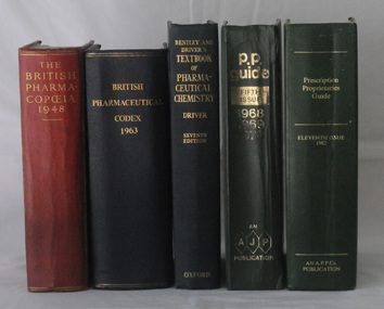
textbooks, 1948 - 1982
These reference books were used in the Orbost pharmacy by various chemists. . Chemists who worked in Orbost included Henry Cottman; James Alfred Dubois Williams; Harry Arthur Murray; Miss P.E .Mason (Phyllis Estelle?); Miss Sybil Monica Buzza; Thomas James Frayer; Australia Shaw; James David Torley; John William Zimmer; Dalkeith William Steele; William Thomas Hollingsworth; E.E. Cohen; R.S. Anderson; Frances John Perry Faith Everard Pardew and Charles Anthony Wurf. "n Britain, the Medical Act of 1858 charged the General Medical Council with the "production of a book containing the list of medicines and compounds, and the manner of preparing them together with the true weights and measures by which they are to be mixed and prepared". The British Pharmacopoeia thus became the official reference book and superseded other previous manuals" (from .South Australian Medical Heritage Society Inc" These reference books have an association with Orbost. Historical works in pharmacy show the evolution of therapeutics and the development of diverse treatment and are therefore a useful research tool. Five heavy reference books. They contain detailed information on drugs and other pharmaceutical materials with standards for substances. Details of each book are in the catalogue folder.pharmacies-orbost reference-books-pharmacy medicine drugs -
 Glen Eira Historical Society
Album - Album page, "Ripponlea", Hotham Street, Circa 1972
This photograph is part of the Caulfield Historical Album 1972. This album was created in approximately 1972 as part of a project by the Caulfield Historical Society to assist in identifying buildings worthy of preservation. The album is related to a Survey the Caulfield Historical Society developed in collaboration with the National Trust of Australia (Victoria) and Caulfield City Council to identify historic buildings within the City of Caulfield that warranted the protection of a National Trust Classification. Principal photographer thought to be Trevor Hart, member of Caulfield Historical Society. Most photographs were taken between 1966-1972 with a small number of photographs being older and from unknown sources. All photographs are black and white except where stated, with 386 photographs over 198 pages.From Victorian Heritage Database citation for Rippon Lea H0614 https://vhd.heritagecouncil.vic.gov.au/places/427(as at 23/10/2020) Rippon Lea was commenced in 1868 by Frederick Sargood, a most successful politician and merchant. He was born in England in 1834 and arrived in Melbourne in 1850. He soon joined his father's wholesale soft goods firm, spending some time as its manager on the goldfields. Sargood entered the Legislative Council in 1874. He was Victoria?s first Minister for Defence in 1883. Sir Frederick Sargood was created CMG. In 1885 and KCMG in 1890 as a reward for his contribution to public life. He died suddenly in 1903. Rippon Lea was designed by the leading firm of architects, Reed and Barnes. Joseph Reed had travelled in Europe in 1863, including northern Italy. When he returned he introduced the use of polychromy. While not the first examples, Rippon Lea and the Independent Church in Collins Street were the best and set a fashion which became a distinctly Melbourne style, particularly used for houses and churches. Its popularity was possible because of the new availability of different coloured bricks. Reed's fine Lombardic Romanesque details soon became debased by others. As Sargood's family grew and his fortunes prospered, Rippon Lea was extended to include 33 rooms - a complete mansion. The cast iron porte cochere and the northern conservatory were added in 1897. The architects were Taylor and Fitts. The ballroom was added in 1882 and remodelled in 1889. Many alterations have changed the interior and exterior during the ownerships of Benjamin Nathan and later his daughter Mrs Louisa Jones in the 1930s and are in their own right of significance. Sir Thomas Bent owned the property from 1903 until 1911 but never lived there. He subdivided much of the land. The original garden dates from about 1868, and it seems that William Guilfoyle of the Botanic Gardens was involved. It was redesigned in a more natural style in the 1880s by Sargood and his head gardener, Adam Anderson. The lake, waterfalls, fernery, hill and grotto are balanced by mighty deciduous trees and conifers. These are interspersed with, but never dominated by Australian species such as eucalyptus and other exotics. The sinuous drive with its carefully prepared approach to the house is notable. The original vegetable gardens, orchard and outer paddocks no longer survive. The shade house is important as the largest known in Australia and possibly the world. Its curved plan and form of construction are particularly notable. It was built about 1884.Page 94 of Photograph Album with four photographs (three landscape and one portrait) of Ripponlea - stables, lookout and neighbouring cottages.Handwritten: "Ripponlea" Hotham Street [top right] / Neg 256 Dec 1972 STABLES [under top left photo] / Neg 248 Dec 1972 LOOKOUT [under top right photo] / Neg 254 Dec 1972 / COTTAGES WILLOW STREET [under bottom left photo] / Neg 259 Dec 1972 STABLES [under bottom right photo] / 94 [bottom right]trevor hart, elsternwick, mansion, hotham street, frederick sargood, reed and barnes, 1860's, 1890's, 1880's, benjamin nathan, nathan, louisa jones, thomas bent, sir thomas bent, william guilfoyle, guilfoyle, adam anderson, ripponlea, victorian, sir frederick sargood, architects, bricks, polychrome bricks, taylor and fitts, stables, lookouts, cottages, outbuildings, rippon lea -
 Glen Eira Historical Society
Album - Album page, Hotham Street, Circa 1972
This photograph is part of the Caulfield Historical Album 1972. This album was created in approximately 1972 as part of a project by the Caulfield Historical Society to assist in identifying buildings worthy of preservation. The album is related to a Survey the Caulfield Historical Society developed in collaboration with the National Trust of Australia (Victoria) and Caulfield City Council to identify historic buildings within the City of Caulfield that warranted the protection of a National Trust Classification. Principal photographer thought to be Trevor Hart, member of Caulfield Historical Society. Most photographs were taken between 1966-1972 with a small number of photographs being older and from unknown sources. All photographs are black and white except where stated, with 386 photographs over 198 pages.Victorian Heritage Database - Hotham Street Road Overbridge HO116 Heritage Overlay - City of Glen Eira https://vhd.heritagecouncil.vic.gov.au/places/43557 (as of 04/07/2021) The Hotham Street road overbridge is located on the Sandringham railway line between Ripponlea and Elsternwick railway stations. It is presumed to have been built by contractors Sharp and Campbell who signed a contract on 25th . November, 1881 to construct a second line of railway between Windsor and Elsternwick. This contract was completed during 1882 and the bridge may have been designed in the year when Robert Watson took over from William Elsdon as engineer in chief for the Victorian railways. It is historically, aesthetically and technically significant. It is historically significant (Criterion A) to the extent that it demonstrates the standards of construction adopted by the Victorian Railways Department when it rebuilt the lines acquired from the private railway companies, (compare the Geelong and Melbourne Railway Co's line from Newport to Geelong, acquired in 1860). It is aesthetically significant (Criterion E) as an intact nineteenth century structure of its type, many similar girder bridges having been renewed with concrete girders in recent years. The bluestone abutments demonstrate high standards of stone masonry and are representative of Departmental work of the period. This bridge forms one of a group of historic structures on the railway to Brighton Beach and therefore contributes to the line's cultural importance as a whole. The survival of the riveted iron girders with their bellied angle iron struts is important since these elements are representative of the civil engineering practices of the Victorian Railways at the time and constitute the technical significance (Criterion F) of the structure.Page 96 of Photograph Album with three photographs (one portrait and two landscape) from Hotham Street - two external views of one house and a railway bridge.Handwritten: Hotham Street [top right] / 112 HOTHAM ST [under top left photo] / BRIDGE OVER SANDRINGHAM RAILWAY [under top right photo] / 112 HOTHAM ST CNR MELBY AVE [under bottom left photo] / 96 [bottom right]trevor hart, elsternwick, hotham street, caulfield, houses, brick, bay windows, verandahs, railway bridges, tunnels, gardens, bluestone, civil engineering, victorian railways, sharp and campbell, contractors -
 Glen Eira Historical Society
Album - Album page, Glenfern, Inkerman Street, Circa 1972
This photograph is part of the Caulfield Historical Album 1972. This album was created in approximately 1972 as part of a project by the Caulfield Historical Society to assist in identifying buildings worthy of preservation. The album is related to a Survey the Caulfield Historical Society developed in collaboration with the National Trust of Australia (Victoria) and Caulfield City Council to identify historic buildings within the City of Caulfield that warranted the protection of a National Trust Classification. Principal photographer thought to be Trevor Hart, member of Caulfield Historical Society. Most photographs were taken between 1966-1972 with a small number of photographs being older and from unknown sources. All photographs are black and white except where stated, with 386 photographs over 198 pages.From Victorian Heritage Database citation for Glernfern H0136 https://vhd.heritagecouncil.vic.gov.au/places/57 (as at 23/10/2020) Glenfern was built on spacious grounds at the corner of Inkerman and Hotham Streets, East St Kilda in two main stages in 1857 and 1876. From 1876 to 1984 Glenfern had only two owners, including the well known Melbourne family of artists, the Boyds. The property was bequeathed to the National Trust of Australia (Victoria) in 1984 and has remained in their ownership. The original Glenfern allotment was bought by John Bakewell in 1856 and sold the following year to Francis McDonnell, a prominent Melbourne investor. By 1858, the house, rated as the most valuable in Caulfield, had been built on the site. Due to financial difficulties, McDonnell offered a number of properties for sale in 1860, including Glenfern. It was not sold at this stage, but subsequently mortgaged in 1862. In 1866 Thomas Watson purchased the property and lived there until 1876 when it was sold to Captain John T. T. Boyd and his wife, Lucy, founders of the Boyd dynasty of artists, musicians, writers and architects. The Boyd family, including twelve children, lived there until 1907, with Lucy Boyd retaining ownership after her husband's death in 1891. In 1907 the property was subdivided and the greatly reduced Glenfern portion was purchased by the Ostberg family, who lived there from 1915. In the latter years of Boyd family ownership and the Ostberg ownership, Glenfern had several tenants and was run as a school on two occasions. The Ostberg family occupancy continued until the death of Miss Amy Ostberg in 1984. From 1929 the property was listed as Glenfern Flats, necessitating various internal alterations over a period of time. The original two storey house, attributed to architect Charles Laing, was extended for the Boyd family in 1876, by architect M. Hennessy. This comprised the addition of a two storey wing to the south of the existing building. Stables were built in 1884 by the architects Smith and Johnson and other outbuildings, since removed, were recorded on the site. The gardens were developed from the establishment of the estate and remnants of early plantings, exotic trees in particular, are evident. Various additions and alterations were made to the house in the twentieth century and a separate block of flats was built on the southern boundary in c1964. Glenfern is a two storey picturesque Gothic house of stuccoed brick with steep, gabled slate roofs, elaborate bargeboards and chimneys of conjoined stacks set diagonally. The original, asymmetrically planned L-shaped house, containing the principal rooms and a rear wing, was designed with two main facades facing north and west. The north facade contains an unusual recessed pointed arch bay formed between twin chimney flues. Internally cedar joinery includes an unusual set of double doors between the drawing room and parlour, the centre pair of which fold back and then slide into the walls. Detailing of the 1876 additions copied that of the original house, including the bargeboards, chimneys and western verandah. Ownership of Glenfern passed to the National Trust of Australia (Victoria) in 1984 and in 2002 transformation of the property into a Centre for the Arts and Culture commenced. This began with the establishment of an Artist-in-residence programme, followed by the Glenfern Writers Centre. Restoration and renovation of the building has been undertaken concurrently with the establishment of this centre. How is it significant? Glenfern, East St Kilda is of architectural and historical significance to the State of Victoria. Why is it significant? Glenfern is of architectural significance as an unusually intact and rare example of the picturesque domestic Gothic Revival house in Victoria. Of particular note are the clustered chimneys, bargeboards and twin arched chimney flues and the folding/sliding cedar doors between the principal rooms. It is significant as an important work of the prominent Melbourne architect, Charles Laing. Glenfern is of historical significance for its connection with the distinguished Victorian Boyd family. It has been recorded in a painting by Emma Boyd, wife of Arthur, in 1885 and in print by writer, Martin Boyd in 1952. Glenfern is of historical significance due to its ownership by only two families from 1876; firstly the Boyds until 1907 and the Ostbergs until 1984. Of note is the resistance to redevelopment in the latter half of the twentieth century and the subsequent survival of the 1907 Glenfern estate.Page 98 of Photograph Album with two photographs (one square and one landscape) of views of Glenfern.Handwritten: "Glenfern" 417 Inkerman Street [top right] / 98 [bottom right]trevor hart, east st kilda, garden, pitched roof, glenfern, hotham street, boyd family, 1850's, 1860's, 1870's, john bakewell, francis mcdonnell, thomas watson, lucy boyd, glenfern flats, charles laing, m. hennessy, smith and johnson, stables, gothic, stuccoed brick, gabled slate roofs, elaborate bargeboards, asymmetrical, cedar joinery, verandah, national trust of australia, centre for the arts and culture, artist-in-residence, glenfern writers centre, gothic revival, clustered chimneys, emma boyd, inkerman street, north caulfield, captain john boyd, artists, writers, st kilda east, national trust of australia (victoria), caulfield, amy ostberg, architects, m hennessy, doors, chimneys, martin boyd, arthur boyd, ostberg family -
 Glen Eira Historical Society
Album - Album page, Ercildoune (576), Inkerman Street, Circa 1972
This photograph is part of the Caulfield Historical Album 1972. This album was created in approximately 1972 as part of a project by the Caulfield Historical Society to assist in identifying buildings worthy of preservation. The album is related to a Survey the Caulfield Historical Society developed in collaboration with the National Trust of Australia (Victoria) and Caulfield City Council to identify historic buildings within the City of Caulfield that warranted the protection of a National Trust Classification. Principal photographer thought to be Trevor Hart, member of Caulfield Historical Society. Most photographs were taken between 1966-1972 with a small number of photographs being older and from unknown sources. All photographs are black and white except where stated, with 386 photographs over 198 pages. Vol 1 Caulfield's Building Heritage by Dr Geulah Solomon states that Ercildoune was the home of Sir Samuel Wilson and later, Arthur Knox. Knox is likely the person who subdivided the land, creating Ercildoune Street.Page 100 of Photograph Album with two photographs (landscape) of Ercildoune and two photographs (one landscape and one portrait) of two other houses on Inkerman Street.Handwritten: "Ercildoune" (576) [top left] / Inkerman Street [top right] / 138 INKERMAN ST [under bottom left photo] / LABASSA GROVE CORNER OF INKERMAN OPPOSITE ERCILDOUNE [under bottom right photo] / 100 [bottom right]trevor hart, east st kilda, ercildoune, mansions, towers, gardens, bloomsbury, inkerman road, labassa grove, attic houses, porches, inkerman street, caulfield north, st kilda east, sir samuel wilson, arthur knox, ercildoune street, house names -
 Glen Eira Historical Society
Album - Album page, Nithsdale now Five Way Hill, Kambrook Road, Circa 1972
This photograph is part of the Caulfield Historical Album 1972. This album was created in approximately 1972 as part of a project by the Caulfield Historical Society to assist in identifying buildings worthy of preservation. The album is related to a Survey the Caulfield Historical Society developed in collaboration with the National Trust of Australia (Victoria) and Caulfield City Council to identify historic buildings within the City of Caulfield that warranted the protection of a National Trust Classification. Principal photographer thought to be Trevor Hart, member of Caulfield Historical Society. Most photographs were taken between 1966-1972 with a small number of photographs being older and from unknown sources. All photographs are black and white except where stated, with 386 photographs over 198 pages. Glen Eira Heritage Management Plan (1996) by Andrew Ward and Associates - Vol 3 "Nithsdale", built for J.S. Crouchin 1858 and extended in 1885 with a tower and associated rooms, survives as testimony to the nineteenth century occupation of the vicinity of the Kambrook/Glen Eira Road intersection. Caulfield's Building Heritage by Dr Geulah Solomon, Vol 1 p49 records it as a small Victorian mansion home on bluestone foundations of Italianate style with a tower. Built for J S Chambers circa 1860, it was built in stages and then the land subdivided in the 1920s. Other owners include Adolph F Brockhoff (of Brockhoff Biscuits company). Names used besides Nithsdale have been Bundoora and Five Way Hill. Page 102 of Photograph Album with four photographs (three landscape and one portrait) of Nithsdale, now known as Five Way Hill. Three views of the tower and one of the house.Handwritten: "Nithsdale" now "Five Way Hill" Kambrook road [top right] / CNR KAMBROOK AND GLENEIRA ROADS [under bottom right photo] / 102 [bottom right]trevor hart, north caulfield, victorian, mid victorian, late victorian, tower, j.s. crouchin, 1850's, 1880's, italianate, rendered, five way hill, nithsdale, slate roof, plaster arches, ornamental columns, triangular pediment, ornamental parapet, cast iron balconies, kambrook road, glen eira road, t crouch, j s crouchin, mansions, j s chambers, bluestone foundations, land subdivision, adolph f brockhoff, bundoora, house names -
 Glen Eira Historical Society
Album - Album page, Rosemont, 112 Kooyong Road, Circa 1972
This photograph is part of the Caulfield Historical Album 1972. This album was created in approximately 1972 as part of a project by the Caulfield Historical Society to assist in identifying buildings worthy of preservation. The album is related to a Survey the Caulfield Historical Society developed in collaboration with the National Trust of Australia (Victoria) and Caulfield City Council to identify historic buildings within the City of Caulfield that warranted the protection of a National Trust Classification. Principal photographer thought to be Trevor Hart, member of Caulfield Historical Society. Most photographs were taken between 1966-1972 with a small number of photographs being older and from unknown sources. All photographs are black and white except where stated, with 386 photographs over 198 pages.From Victorian Heritage Database citation for Rosemont HO124 - 112 Kooyong Road Caulfield North https://vhd.heritagecouncil.vic.gov.au/places/35588 Rosemont'' is situated at no.112A Kooyong Road, Caulfield North and was built in 1869 for Godfrey Howitt, physician, president and honorary physician of the Melbourne Benevolent Society, Council member of the University of Melbourne and founding vice president of the Royal Society of Victoria. It is historically significant (Criterion A) as an early and substantial villa residence demonstrating Caulfield's early attraction as a residential retreat for Melbourne's elite. This significance is enhanced by the associations of the place with Godfrey Howitt and later James Grice, National Bank chairman and owner of "Stonnington" in Glenferrie Road, Malvern and Thomas King, councillor and successful negotiator for the extension of the electric tramway system to the Municipality.Page 110 of photograph album with 4 photos (portraits) of varying views of Rosemont's exterior and garden.Handwritten: "Rosemont" 112 Kooyong Road [top right] / Neg 97 1972 / [under top right photo] / 110 [bottom right]trevor hart, caulfield, john bakewell, francis mcdonnell, gabled slate roofs, rosemont, caulfield north, kooyong road, 1860's, godfrey howitt, james grice, thomas king, villa residence, decorative brickwork, curved windows, bay window, garden, victorian style, mansions, polychrome bricks, porches, arches, parapets, verandahs, slate roofs -
 Glen Eira Historical Society
Album - Album page, Rosemont, 112 Kooyong Road, Circa 1972
This photograph is part of the Caulfield Historical Album 1972. This album was created as part of a project from approximately 1966-1972 by the Caulfield Historical Society to assist in identifying buildings worthy of preservation. This album is related to a Survey the Caulfield Historical Society developed in collaboration with the National Trust of Australia Victoria and Caulfield City Council to identify historic buildings within the City of Caulfield that warranted the protection of a National Trust Classification. Photographers Jenny O’Donnell and Trevor Hart, members of Caulfield Historical Society. Some photographs are older and from unknown sources. All photographs are black and white except where stated.From Victorian Heritage Database citation for Rosemont - HO124 112 Kooyong Road Caulfield North https://vhd.heritagecouncil.vic.gov.au/places/35588 Rosemont'' is situated at no.112A Kooyong Road, Caulfield North and was built in 1869 for Godfrey Howitt, physician, president and honorary physician of the Melbourne Benevolent Society, Council member of the University of Melbourne and founding vice president of the Royal Society of Victoria. It is historically significant (Criterion A) as an early and substantial villa residence demonstrating Caulfield's early attraction as a residential retreat for Melbourne's elite. This significance is enhanced by the associations of the place with Godfrey Howitt and later James Grice, National Bank chairman and owner of "Stonnington" in Glenferrie Road, Malvern and Thomas King, councillor and successful negotiator for the extension of the electric tramway system to the Municipality.Page 111 of photograph album with 1 photograph (portrait) of Rosemont's roof line.Handwritten: 111 [bottom left]trevor hart, caulfield, john bakewell, francis mcdonnell, gabled slate roofs, rosemont, caulfield north, kooyong road, 1860's, godfrey howitt, james grice, thomas king, decorative brickwork, bay window, garden, mansion, chimneys, victorian architectural style, polychrome bricks, roofs -
 Glen Eira Historical Society
Album - Album page, Bureel (Kooyong Road), Circa 1972
This photograph is part of the Caulfield Historical Album 1972. This album was created in approximately 1972 as part of a project by the Caulfield Historical Society to assist in identifying buildings worthy of preservation. The album is related to a Survey the Caulfield Historical Society developed in collaboration with the National Trust of Australia (Victoria) and Caulfield City Council to identify historic buildings within the City of Caulfield that warranted the protection of a National Trust Classification. Principal photographer thought to be Trevor Hart, member of Caulfield Historical Society. Most photographs were taken between 1966-1972 with a small number of photographs being older and from unknown sources. All photographs are black and white except where stated, with 386 photographs over 198 pages. From: Glen Eira Heritage Management Plan 1996 by Andrew Ward In 1856, John Allee, a builder from Brighton, purchased C.A. 37 on the south-west corner of Glenhuntly and Kooyong Roads. The land comprised just over 45 acres. By 1863, Francis John Sidney Stephen, a lawyer and cousin of J. Wilberforce Stephen, owned most of lot 37. By 1866, Stephen had a built a "small mansion" named ''Burreel". It was a brick house and Stephen lived there until 1882. By 1884, Mrs Buxton of Hillside Terrace, East Melbourne, had purchased the property. Richard Buxton, a gentleman was listed as occupant and the house described as "brick, eight rooms". NAV was £300. Richard Buxton continued residency in 1887 however in 1888, George Allen, music seller, became occupant. At that time the house had thirteen rooms on twenty-three acres of land. Twelve people lived there and NAV was £920. In 1900, Daniel Luxton, stock and sharebroker and the Honourable John Taverner, M.H.A. leased the property. Fourteen people lived there. Mrs Buxton continued as owner. By 1910, ownership had passed to Mrs Mary Neate, who converted the house to a nursing home. The land had been subdivided by 1913 and sold by ''Buxtons Estate". Burreel Avenue, Baxter, Buxton and Hoddle Streets were created. "Burreel" was rated to Burreel Avenue and stood on lot 13 with frontages to Burreel Avenue and Kooyong Road of 198' and 214'. The house had ten rooms. NAV was £60. Mary Neate, a nurse, continued as owner/ operator of ''Burreel" nursing home in 1927. At that time there were sixteen rooms and fourteen residents. NAV was £100. Mrs Neat remained there until 1947. In 1948, the house was turned into apartments. In the 1980's, the Alexander family purchased it and restored it to a private residence.Burreel 331 Kooyong Road, ELSTERNWICK VIC 3185 - Property No B4950 National Trust https://vhd.heritagecouncil.vic.gov.au/places/65648 This is a large and substantially intact example of the grand villas of nineteenth century Melbourne. The bulk of the house most probably was built in 1866-1868 for Francis John Sidney Stephen, a prominent and highly regarded Melbourne solicitor and a member of an illustrious legal family. Stephen conducted a lucrative private practice and in 1845 was appointed first solicitor to the City of Melbourne; a position he held until his death in 1895. He took an active part in the development of Caulfield and was Shire President in 1874 and 1877. He was a resident at Burreel from 1868 to 1882. The house has evolved in stages, the rear wings possibly remaining from a house built during the 1850s. The existing ornate cast iron verandah was probably built between 1882 and 1888 during the residence of Richard Buckhurst Buxted, a notable boom period auctioneer and real estate agent. George Allan, the founder of Allan's music store, was another important occupier from 1888 to 1991. Bureel's essentially residential quality has been retained and the interior has been well preserved. The significance of this building does not rest in any single unusual outstanding architectural feature, or in its association with a particularly prominent member of society in the past, but rather in the consistent integrity of both the interior and exterior, which results in the survival of an outstanding example of this type of residential building and its associations with two notable citizens. Classified:11/08/1990Page 113 of photograph album with 1 photograph of Burreel in its garden.Handwritten: Bureel [top left] / 113 [bottom left]trevor hart, caulfield, caulfield north, kooyong road, thomas king, mansion, 1860's, bureel, burreel, francis john sidney stephen, city of melbourne, shire president, 1850's, verandah, nursing home, john allee, ornamented corner stones, new orleans manner, plaster rendered, mrs luxton, vincent willis, alexander family, victorian architectural style, ornate cast iron work, lawyers, brick houses, richard buxton, richard buckhurst buxton, george allen, george leavis allan, allans music, daniel luxton, john taverner, mary neate, buxtons estate, land subdivision, mary neat, gardens