Showing 6052 items
matching irrigator
-
 Glen Eira Historical Society
Article - Glen Eira Parks and Gardens
This file contains four items. 1/ An article in the Glen Eira News reporting on a new park with indigenous planting and an interpretive walk being developed to link Duncan McKinnon Reserve and Packer Park in Murrumbeena, dated September 2000. 2/ An article from the Glen Eira Leader on the converting of sports grounds from cool season to warm season grasses, as well as the installation of subsurface drip irrigation at Princes Park, Caulfield South, dated March 2012. 3/ An article from the Caulfield/Port Phillip leader reporting Caulfield RSL military historian Carl Johnson’s appeal to have a “lone pine” in Caulfield Park designated as a war memorial, dated 11/9/2012 4/ An article from the Glen Eira/Port Phillip Leader reporting on the Friends of Caulfield Park organising the first band stand concert in over twenty years with the City of Glen Eira Band, dated 6/11/2012glen eira council, hawthorn rd caulfield, glen eira rd caulfield, glen eira, caulfield, parks, reserves, leila rd caulfield, glen eira city council, landscaping, memorial park, kooyong rd caulfield north, caulfield recreation tennis club, murrumbeena rd caulfield, churchill green housing estate, north rd caulfield, boake street caulfield, exservices organisation, rsl clubs, sporting clubs, recreations, sportsgrounds, clubs, tennis clubs, associations, leisure, cultural events, cultural activities, sports establishments, recreations establishments, irrigation, water conservation, conservation of natural resources, water supply, ovals, playing fields, tennis courts, murrumbeena park, school concerts, musical activities, musical events, glen eira artists society, dimarco lisa, st. aloysius college, band rotundas, entertainment structures, musical ensembles, city of glen eira band, bands, the friends of caulfield park, gallipoli lone pine, princes park, packer park, duncan mckinnon reserve, king george reserve, caulfield park, glenhuntly park, glen huntly park, bentleigh reserve, victory park, schools, education establishments, recycling, water disposal, cultural structures, cultural establishments, caulfield rsl, johnson carl, war memorials, monuments, memorials, avenue of honour, “lone pine”, glen eira leader, glen eira news, caulfield/port phillip leader, glen eira leader -
 Bendigo Historical Society Inc.
Document - CONNELLY, TATCHELL, DUNLOP COLLECTION: LEGAL PAPERS, 1889 - 11895
Document. Connelly, Tatchell & Dunlop. Legal papers. 1 - 1892 - Wishart D, Macorna. Re costs. 2 - 1892 - McKoene, deceased. Notes concerning. 3 - 1892 - Echuca Shire. Re costs. 4 - 1891 - Pierce & Perry. Re costs. 5 - 1891 - Hopkinson, deceased. Re costs. 6 - Irrigable Estates to Prior. Re costs. 7 - 1889 - 1891 - Shire of East Loddon. Re costs. 8 - 1910 - McNamara John, Mosquito Creek. Costs re Foy. 9 - 1895 - Letter to The Officer in Charge of Police, Raywood - Albert C Dungey? (? Const. 4008). Mentions G H Lezard. 10 - 1890 - Letter dated 15 Jul 1890 signed S?T?M? (surname unreadable - (?ath). 11 - 1894 - Letter dated 20 April 1894 written by Fordyce? Joseph acting for liquidator.cottage, miners, connelly, tatchell & dunlop, wishart d, mckoene, echuca shire, pierce & perry, hopkinson, irrigable estates, prior, shire of east loddon, mcnamara john, foy, officer in charge of police raywood, dungey? a c, lezard g h, fordyce jos., prior m a mrs -
 Warrnambool and District Historical Society Inc.
Map - Maps, Soldiers Settlement WW2, Circa 1950
The soldiers' settlement scheme operated after the first and second world wars in an effort to more closely settle the land and also give opportunities to returned soldiers. Crown land and other larger estates were acquired for the purpose. Most of these maps relate to the area north of Warrnambool where many of the subdivisions were parts of larger estates.These maps pertaining to the Soldiers' Settlement program, relate to an interesting part of Australian and local history. As such they have historic and social interest and significance.A collection of 25 paper maps which relate to to the soldiers settlement post World War 2. Some have details of the people allocated the land and some smaller maps have the printed details of the applicants requirements.Text is black on white paper which in some cases is quite aged. The maps are as follows: .1 Narrapumelap Estate ( Ripon & Hampden) .2 Narrapumelap Estate Part 2 (Villers & Ripon) .3 Narrapumelap Estate Part 3 ( Villiers & Ripon) .4 Burrumbeet Estate ( Ripon) .5 ' Berrambool' Estate 9 Hampden & Villiers) .6 ' Hopkins Hill' Estate Villiers 4011 acres .7 Caramut North No 2 Estate ( Villiers ) .8 ' Morpor' Estate ( Villiers) 4172 acres .9 ' Morgiana' Estate ( Normandy) 3453 acres .10 ' Chatsworth House' ( Villiers) 9341 Acres .11 ' East Elwood' Estate Villiers 2407 acres .12 Grey's Estate ( Mornington) 1151acres .13 ' Rowes Estate' ( Buln Buln Gippsland 733 acres .14 'Tarrone' Estate No 2 Part map .15 'Chaldon Meade' Estate (Bourke) Bulla 517 acres .16 ' Terranallum South' Estate Hampden 3757 acres .17 ' Brung Brungle' Estate Dundas 695 .18 ' Armidale ' Estate ( Dundas)2108 acres .19 ' Moyne Falls' Estate ( Villiers) 627 acres .20' Yulong' Estate 9 Lowan 6321 acres .21 Murray Valley Irrigation District 9 Moira)113 acres .22 Murray Valley Irrigation District 103 acres .23 ' Mount Fyans' Estate ( Hampden) .24 ' Barwidgee ' Estate ( Villiers) 4277 acres .25 'Pine Hills' Estate 2nd portion ( Lowan) 6190 acres narrapumelap, berrambool, hopkins hill, caramut north, morpor, chatsworth house, east elwood, terrinallum, moyne falls, tarrone, caramut soldiers settlers, burrumbeet, morgiana, grey's estate mornington, chaldon meade, brung brungle -
 Bendigo Historical Society Inc.
Document - CONNELLY, TATCHELL, DUNLOP COLLECTION: LEGAL PAPERS, 1896
Documents. Connelly, Tatchell & Dunlop. 1 - 1896 - Letter from Roche Mary re debt. 2 - 1896 - Letter from Dean A F, 'Yambuna', Tongala Rly Stn, Victoria. 3 - 1896 - Letter from Bryan J W re Bartlett Bros. 4 - 1896 - Letter from Sims D re Dwyer. 5 - 1896 - Letter from McKinnoz? Arch M. Mentions names Fairclough & Brown. 6 - 1896 - Letter from Moylan T F. Mincha. Mentions Fairclough & Brown. 7 - 1896 - memo from Kerang Office to Bendigo Office re Grigg v Patterson. 8 - 1896 - Memo from Kerang Office to Bendigo Office re Moylan to Perry. 9 - 1896 - Letter from Bell J, Secretary, Trust Office, Mincha, Tragowel Plains Irrigation and Water Supply Trust. Dated Feb 29 1896.cottage, miners, connelly, tatchell & dunlop, roche mary, dean a f, bryan j w, bartlett bros, sims d, dwyer, mckinnoz? arch m, fairclough, brown, moylan t f, grigg, patterson, moylan, perry, bell j, tragowel plains irrigation & water supply trust -
 Puffing Billy Railway
Portable Compound Steam Engine, Marshall & Son's - Builders Number 48317, circa 1908 / 1909
Portable Compound Engine - Marshall & Son's. Builders Number 48317 Built by Marshall Sons & Co., Ltd., Gainsborough, England (Builder’s Number 48317 of approximately 1908/1909), to the order of Robison Brothers, Engineers, South Melbourne. It was used for operating a pump to supply irrigation water at Robinvale in Northern Victoria. Robison Bros & Co. P/L was founded by James McFarlane Robison and his brothers in 1854, initially as plumbers and coppersmiths, the firm expanded into general engineering, boiler-making and brass, iron and steel founders and became one of Melbourne's most important engineering firms. They constructed railway bridges, gold mining equipment, railway locomotives, pumping stations, brewing vessels, abattoir machinery, amongst much else and including the first turnstiles at the Melbourne Cricket Ground. A portable engine is either a steam engine or an internal combustion engine, that remains in one place while operating (providing power to machinery), and can be easily moved from one work site to another. Mounted on wheels or sometimes skids, it is required to be towed between work sites.Historic - Industrial Portable Compound Engine - steam engine - Marshall & Son's. Marshall & Son's Portable Compound Engine - Builders Number 48317 made of steel Marshall & Son's. Builders Number 48317puffing billy, state rivers and water supply commission of victoria, portable compound engine - marshall & son's., portable compound engine, marshall sons & co., ltd., robison bros & co. p/l -
![Map, Liquidator's sale, 1896. [Woolpack Estate, Bacchus Marsh]](/media/collectors/5e461d8021ea67224c82f2a1/items/6779ee97032b72846b5995f2/item-media/6779ef33032b72846b599b30/item-fit-380x285.jpg) Bacchus Marsh & District Historical Society
Bacchus Marsh & District Historical SocietyMap, Liquidator's sale, 1896. [Woolpack Estate, Bacchus Marsh]
The Woolpack Estate was an area of land owned by various landowners in the Bacchus Marsh area since the early Colonial period of the 1840s. The area was located on the eastern side of the Bacchus Marsh township about 7 kilometers from the town. The Lerderderg River ran through part of the land and so did the Melbourne to Ballarat Road. The historic Woolpack Inn associated with James Crook was also located on this land. By 1896 150 acres of this land was under the control of liquidators for the Federal Bank of Australasia who instructed that the land be sub-divided and sold in lots by public auction. A successful sale was held on 24 June 1896. Most of the blocks of land were sold for higher than expected prices and most of the buyers were people from the town and district of Bacchus Marsh. The map includes various details about the land which is described on the map as an "important sale of rich alluvial irrigable flat land in the Bacchus Marsh Valley, and other properties". The auction was conducted by the local agents W. Anderson and Bence in conjunction with Pearce Brothers also of Bacchus Marsh.A single page paper map showing a plan of 150 acres of land from the Woolpack Estate to be sold in various lots in June 1896. Also shown on the map are lots for sale at Robinson's Farm on Coimadai Creek and allotments near Bacchus Marsh railway station, including lots on Government Road (East Maddingley Road), View Street and Government Road (Parwan Road). No scale provided. The map is pasted into a bound volume containing 76 maps or plans in total. High resolution digital image stored on BMDHS computer network. land sales bacchus marsh, bacchus marsh victoria maps, woolpack estate bacchus marsh victoria -
 Wooragee Landcare Group
Photograph, 27th February, 2004
This photograph was taken at Wooragee Hall on the Friday 27th February, 2004 as part of an event called Foxy Night Out. This event was about sharing awareness about the impacts of foxes in rural areas and discussing methods to control their populations. There were two mains speakers at this event, the first; Camille Veselsky, a specialist in fox behaviour who worked for the Hume Rural lands Protection Board on pest animal control, and the second; Leanne Wheaton, a nature conservationist. Pictured in this photograph (left -right): Mary Prowse, Leanne Wheaton, Tony Prowse, Ray Henderson. Leanne Wheaton holds a portable electric fence, that is useful in preventing fox attacks on wildlife, including Bush Stone-Curlew nests Regional areas like Wooragee are susceptible to fox attacks due to the availability of food such as rubbish, scraps, native wildlife and livestock. Foxes can have a huge impact on native wildlife and domestic life as they are known to chew through irrigation systems, dig-up and defecate in gardens, raid rubbish bins and harass other domestic animals.This photo is a record of the events that Wooragee Landcare organises in order to raise awareness and educate about environmental conservation issues in the area. It shows practical solutions that have been considered in fox controlLandscape coloured photograph printed on gloss paperReverse: WAN NA 0A2A0N0 NNN+ 1 6329 / [PRINTED] (No.6A) / 497 wooragee, wooragee hall, wooragee landcare, wooragee landcare group, fox, foxy, foxy night out, leanne wheaton, mary prowse, tony prowse, ray henderson, wheaton, prowse, henderson, electric fence, portable electric fence, landcare workshop, fox control project -
 Wodonga & District Historical Society Inc
Domestic object - Propert's Whistling Egg Timer and egg whisk
John and Emma Propert emigrated from England in 1877 and settled in New South Wales . Several of their 11 children became talented inventors, designing items ranging from kitchen utensils to coaches and later pop-up caravans. One of the most successful was Charles, who designed and built kitchenware over many decades. His earliest invention was irrigation equipment including patenting the common backyard rose sprinkler. Propert became a household name when he began making a wide range of kitchen implements for decades including flour sifters and chip cutters. By the 1970s Propert was Australia’s leading brand of kitchen and bathroom scales. By far the most successful product was a ball-driven egg beater, trademarked as the Ezy Whisk or Swift Whisk. In the days before electric beaters, the Ezy Whisk and Swift Whisk were market leaders and were exported world-wide. Charles Propert and his son Bertram manufactured more than a quarter of a million egg beaters a year in the early 1950s which explains why so many are still in use today.These items are significant because they were widely used throughout Australia in the 1950s by a major Australian manufacturer.Two Propert's kitchen appliances - a stainless steel Whistling Egg Timer and a Swift Whisk BeaterOn Egg Beater : A PROPERT PRODUCT MADE IN AUSTRALIA PATENT BALL DRIVE SWIFT WHIP STAINLESS STEELkitchen utensils, propert kitchen appliances -
 Wooragee Landcare Group
Photograph, 27th February, 2004
This photograph was taken at Wooragee Hall on the Friday 27th February, 2004 as part of an event called Foxy Night Out. This event was about sharing awareness about the impacts of foxes in rural areas and discussing methods to control their populations. There were two mains speakers at this event, the first; Camille Veselsky, a specialist in fox behaviour who worked for the Hume Rural lands Protection Board on pest animal control, and the second; Leanne Wheaton, a nature conservationist. Pictured in this photograph, background (left -right): Graeme Missen, Bob Stelling, Quentin Mansfield, unknown, unknown; Colin Payne. Foreground (left -right): Tony Prowse; Mary Prowse, Digby Race. Also pictured are two taxidermy goannas on top of the tables which were brought in as an example of reptile species that are vulnerable to fox attacks. Regional areas like Wooragee are susceptible to fox attacks due to the availability of food such as rubbish, scraps, native wildlife and livestock. Foxes can have a huge impact on native wildlife and domestic life as they are known to chew through irrigation systems, dig-up and defecate in gardens, raid rubbish bins and harass other domestic animals. (One paragraph about the significance ie: The photograph is an example of the type of events hosted by Wooragee Landcare to inform the general public about potential risks to private and public property. .....)Landscape coloured photograph printed on gloss paperReverse: WAN NA 0A2A0N0 ANN+ 1 6329 / [PRINTED] (No.5a7) / 496wooragee, wooragee landcare, fox, foxy -
 Red Cliffs Military Museum
Document, Obituary, 12:MMMM, 1976 (exact); Walter Thomas West passed away 4th December 1976 and his funeral was held 7th of December
Attached to his R.S.L. Membership Card along with the funeral notice, is a subsequent newspaper article written at the time of Walter West's death, which reads: Death of Pioneer Settler/ A pioneer settler of/ the Red Cliffs irigation/ district and one of the/ last men to be evacuated/ from Gallipoli, died sud/denly on Saturday night/ aged 84./ In 1922 Mr. Watler Thomas/ West came to Red Cliffs/ where he established Block/ 86 in the irrigation district./ He lived there until his/ death on Saturday after playing bowls at the Red/ Cliffs rinks on Saturday/ afternoon./ Mr. West was born in Jeparit and served with the/ 24th Battalion in Egypt and/ Gallipoli./ He was awarded the Mili/tary Medal in France in/ 1917 and the Military Cross/ in 1918 when he captured/ single handed an enemy/ machine gun post./ He settled at Red Cliffs/ on his return when the/ area was placed under irri-/gation./ For 25 years he operated/ a unique partnership with/ the late Mr. Martin Nippe, his adjoining property/ owner. The pair pooled their/ horticultural equipment for/ joint use./ Mr. West joined Mildura/ Legacy in 1942 and was an/ active member until his/ death./ The funeral will be held at the United Church, Red/ Cliffs this morning at 10.30Type written obituary, presumably used when Walter West,MC,MM, died.Walter West MC,MM/ Red Cliffs residents were saddened to learn of the sudden passing on Saturday last/ of Walter Thomas West MC,MM., a Pioneer/settler and well respected citizen./ "Wal" as he was affectionately known, was/ born at Dandenong some 84years ago./ He served with distinction in World War 1/ with 24th Battalion. He was an original ANZAC, and also saw service in/ Egypt and France. He received two awards for gallantry in the field - The Military/ Medal in France 1917 and the Military Cross in France/ in 1918 when he was responsible for the/ single handed capture of an enemy gun and crew./ He was an original soldier settler and developed/ his fruit block in Red Cliffs which is still/ operated by his son Tom. In 1922 he/ became an original Trustie of the Methodist/Church and was the last surviving original/ Trustie. He served on the Board of/ directors of the Red Cliffs Co-Operative Co.Ltd/ from 1954 to 1967, and was Chairman of Directors/ in 1963 and 1964. He showed a keen interest/ in youth activities and some excellent cricketers/ were produced as a result of his coaching of/ the Methodist Junior Cricket Team. He was an/ active and keen member of Mildura Legacy/ for 34 years, serving as President in 1947 and 1948./ He was secretary of the Cemetary Trust for many years, served on the Hospital Committee/ was a member of Memorial Lodge, a member of Red Cliffs Senior Citizens Club and a /member of Red Cliffs Sub-Branch R.S.L. since / it's inception./ He was a keen member of the Red Cliffs/ Bowling Club and took part in a club event on/ the day of his passing./ It was the pioneer settler and men with ability/ and initiative of Walter West that brought/ out the Community Spirit which resulted in/ the Red Cliffs we know today.1918, 1917, ww1, walter, thomas, west, mm, mc, 24th, battalion, aif, gallipoli, bullecourt -
 Sunbury Family History and Heritage Society Inc.
Photograph, Horse Racing, c1900 - 1910
The people in the photograph were enjoying a day out at a Sunbury race meeting some time in the early 1900s. Races at Sunbury began in 1886 with the establishment of the Sunbury Racecourse that was located along Racecourse Road on a section of the Rupertswood Estate on land consisting of six furlongs and two straights. The site included a patron’s stand, saddling paddock, bookmakers’ enclosure, two bars, a committee room, judges box, stables, toilets, six entrance gates and ticket boxes. Special trains from Melbourne brought patrons and horses to the Sunbury race meetings. A report in the Melbourne Argus newspaper in 1922, stated that city taxi drivers came out to Sunbury to drive patrons to the racecourse, which was located about 3 kms from the Sunbury station. Some time however, between 1886 and 1901, there was a period when the racing club had been inactive. A meeting was called in 1901 to restore the club’s activities. With a substantial loan from Mr. Clarke the committee was able to organise the installation of a turnstile, perimeter fencing and irrigation of the course by a windmill that pumped water from a recently constructed dam that was on the estate. The club continued to function until 1942, during World War 2, and did not resume activities after the end of the war. The land was eventually sold for housing development. The Sunbury Race meetings were popular with the racing fraternity not only in the district but further afield and were deemed sufficiently important to run special trains from Melbourne to Sunbury on Race days.A non-digital sepia photograph with a strong cardboard backing of a crowd of people dressed smartly for a day out at the races. Most of the spectators are seated in a long marquee. Three men on the RHS are looking at a horse that is lying on the ground.On the back of the card there are scribbled notes and numbers which seem to indicate the photograph has been used for a publication at some time.sunbury race meetings, sunbury race course, racecourse road -
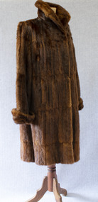 Brighton Historical Society
Clothing - Coat, Water rat fur coat, c.1930s
This coat belonged to Brighton resident Audrey Winifred Pickett (nee Heriot; 1915-2011). The coat is made from the pelts of rakali, also known as the Australian water rat, a native rodent species similar to an otter. Growing up to 35 centimetres in length, rakali typically live in burrows near water, feeding on fish, insects, yabbies and waterbirds. Throughout the early twentieth century, they were widely considered to be a nuisance and were hunted for their soft and waterproof fur. Demand for rakali pelts increased during the 1930s Depression years, when a ban was placed on the import of overseas furs; rakali fur became a popular substitute for the fur of the American muskrat. The species was placed under a protection order in 1938, although periodic culls were allowed until 1957 due to their perceived destruction of irrigation banks and fishing nets. Audrey recalled that the coat was made for her by furrier F. J. Ellemor after a large cull of rakali. The coat was displayed in the window of Ellemor's Block Place store. F. J. Ellemor Pty Ltd was established in 1908 by furrier Francis John Ellemor (1867-1944) and continued into the late twentieth century under the management of his son Wilfred (1801-1972). Francis and his wife Edith lived in Rothesay Avenue, Brighton from the late 1930s.Three-quarter length brown fur coat made of Australian water-rat (rakali) pelts. Wide raised collar and cuffs. Fastens centre front with two large hooks and eyes. Lined with chocolate brown silk satin.Label, woven brown on beige silk, centre back neck: created by / F. J. Ellemor / FURRIERS / MELBOURNEfur coat, rakali, australian water rat, melbourne fashion, audrey winifred heriot, audrey winifred pickett, audrey winifred north, francis john ellemor, f. j. ellemor, furrier -
Tatura Irrigation & Wartime Camps Museum
Photographs, Anderson collection of irrigation and farm photos, c.1920 (Loaned), c.1920
Collection of photos taken c.1920 by the Anderson family. Carlton and Bill Anderson left Murchison for a soldier settlement block at North West Mooroopna, 2 miles from the school. Bill had been a stretcher bearer in WW1. Photos taken by Anderson family of general farming activities, irrigation channel construction with horse teams, Goulburn Weir, Waranga Basin western outlet structure and channel, official opening ceremony. Photos loaned for copying.|1. Outlet structure, possibly the opening.|2.Western Channel.|3.Waranga Basin inlet.|4. Waranga Basin outlet.|5,6.Goulburn Weir.|7,8 Channel construction with horse teams.|9.Skid scoop.|10. Group at Bain.|11."Spot", Bill Anderson and the team.|12.Teams take time off.|13.Washing up.|14.Spring cart and "Smoko"|15.Bill Anderson holding horse.|16.Team of four.|17.A good crop.|18.Wonkey scoop with two horse team.|19,Horses at rest.|20.Head in nose bag.|21.Bill Anderson & Marty Clooney, tents, wagons and gig.|22.Wally Wybrow grooming horse.|23 Bill Anderson, Marty Clooney and furphy tank.|24. Four horse teams.|25.Carlton Anderson? cutting hair.|26,27.|28.Three wheel trolley made from old harvester.|29. Harvester.|30.Wally.|31.Marty Clooney and horse.|32|33.Seven horse team.|34-43.Various farm photos -
Tatura Irrigation & Wartime Camps Museum
Photographs Loaned, Charlie Hogan Estate photos
Photos loaned for copying. Collection of photos loaned from Estate of Charlie Hogan.|Photo 1.Mick Hogan; Mrs. Hogan & Charlie Hogan.|Photo 2. Nora Keane whose mother was a Hogan.|Photo 3. Mick Hogan & Thomas Flanagan snr,, Hilston, early 1900s.|Photo 4. Ray Glover; Norm Doncon, Charlie Hogan &Tom Cornish.|Photo 5. Ray Glover; Bill Mitchell &Tom Hunter.|Photo 6. James & Annie Brady. James son ofJames & Julia. Annie, dau. of Thomas & Annie Hogan.|Photo 7. Jack O'Toole & Charlie Hogan.|Photo 8. Georgie Hing, thought to have been the Chinese market gardener at the Whim Inn corner, and who was killed while riding his bike.|Photo 9. Hogan Street building of Stan Tudor & Kilpatrick & McLellan, stock and station agent. Building now owned by Dawes & Vary, Solicitors.|Photo 10 & 11. Tatura Coursing Club 1926. St. Ledger Plumpton Coursing won by Ryan Bros.|Photo 12 & 13. In two halves. Rodney Irrigation Trust Commissioners and staff, possibly in front of original Tatura Mechanics Institute building. (Mick Cussen third from left seated; Thomas Hogan white beard seated with legs crossed. Billie Wilson snr. standing at rear left side.)|Photo 14. Group in front of Catholic church, c. 1925, boy on left thought to be Charlie Hogan. -
 Wooragee Landcare Group
Photograph, 3rd April 2004
This photograph depicts people attending the 'Spotlight on Fox' event watching a demonstration. The event was conducted as part of an awareness campaign highlighting damage done to farm and domestic animals and native wildlife in April 2004. This date is suggested by the photograph's position in the 2004-2005 Wooragee Landcare Group Coordinator's Report folder. A note accompanying the item suggests an alternative date of February 2004, however. This event raised awareness about the impacts of foxes in rural areas and provided practical training in techniques to control their populations. Flyers contained in the parent folder suggest that baiting may have been agreed as a method of fox control as the event depicted was followed by a two week baiting campaign a fortnight later. Pictured in this photograph, left to right: unknown; Sue Berwick ; Jerry Alexander; rest unidentified. A note accompanying the items suggests the photograph may have been taken by Karen Bowley or Maree Missen. Regional areas like Wooragee are susceptible to fox attacks due to the availability of food such as rubbish, scraps, native wildlife and livestock. Foxes can have a huge impact on native wildlife and domestic life as they are known to chew through irrigation systems, dig-up and defecate in gardens, raid rubbish bins and harass other domestic animals. Ground-dwelling native species are particularly susceptible to predation by foxes, which when combined with loss of habitat can endanger these species. Affected species include Speckled Warblers, Plovers, Diamond Firetails, Spotted Quail-Thrushes, Turquoise Parrots, Dunnarts, Bandicoots, Phascogales, skinks, geckos and legless lizards. This photograph is significant as an example of awareness raising and threat control programs undertaken by Wooragee Landcare Group in the 2000s in Indigo Shire.Landscape coloured photograph printed on gloss paperReverse: WAN NA 0ANA2N0 NNN 0 8743 / [PRINTED] (No. 13) / 259wooragee, wooragee landcare, indigo shire, north-east victoria, foxes, fox, pest control, vermin, conservation, baiting, trapping, events, 2004, wildlife, speckled warbler, plovers, diamond firetails, spotted quail-thrush, turquoise parrots, dunnarts, bandicoots, phascogales, skinks, geckos, legless lizards, farming, chickens, ducks, guinea-pigs -
 University of Melbourne, Burnley Campus Archives
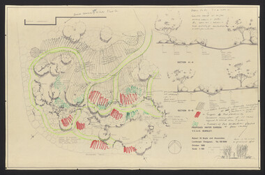
Plan, Water Garden, 1987-1995
(1) Water Garden V.C.A.H Burnley Irrigation Plan, drawn by M.D. 12.11.87. (2) Tracing paper copy, Proposed Pool Development Native Garden V.C.A.H. Burnley -Survey of approximate dimensions showing fall and depth of pools. Drawn by J.H.K. 9.9.88. (3) Rough coloured plan, Water Garden Planting Plan. (4) Proposed Water Garden V.C.A.H. Burnley by Robert W. Boyle and Associates October 1988, with handwritten annotations by James Hitchmough. (5) Coloured final version. (6) Tracing paper copy, Planting Scheme Native Garden VCAH Burnley. Design by James Hitchmough. Drawing J.K. 13.8.90. (7) Section Native Grassland Burnley Campus - Larger Tree Cover by Marika Kocsis & Martin Hopkins. Drawn by Leigh Stone 25.9.95. Survey Plan, no key to numbers. (8) Section Native Grassland by Marika Kocsis & Martin Hopkins. Drawn by Leigh Stone 20.9.95. No key to numbers. (9) Tracing paper copy Native Garden by Paul Eaves 6.9.90. Scale 1:100. Also 2 plant lists (11.0478/1 and /2). Also see 11.0478 List of plants. (11) Letter to P. Tulk from Robert Boyle dated 07.10.1988 "Re: Cost Estimates for Construction of Proposed Water Garden."water garden, vcah, robert w. boyle, james hitchmough, jill kellow, marika kocsis, martin hopkins, leigh stone, paul eaves -
 Flagstaff Hill Maritime Museum and Village
Functional object - Water Pump, Goulds Manufacturing Co, 1915-1925
Gould manufacturing company was founded in 1848 at Seneca Falls, New York when Seabury S. Gould purchased an interest in Downs, Mynderse & Co. and the firm became Downs & Co. Wooden pumps were produced at the time in an old cotton factory building. In 1869, the name of the company was changed from Downs & Company to Goulds Manufacturing Company. Seabury S. Gould was regarded as a man of unusual vision, and as the founder of Goulds Manufacturing Company he was keen to start producing cast iron pumps. An iron pump, he believed, would overcome all the disadvantages of a wooden pump. It would be strong and efficient and provide fresh flowing water for the pioneers. He ran the company until after the American Civil War and because Goulds Manufacturing had a foundry, they also produced all kinds of cast iron products such as corn shellers, bells, sad irons, sinks, tools, and a line of fire engines. From 1848 to 1964 a Gould family member had always been President of the company. However, the company ownership in 1964 was transferred from family-owned stock to public offerings and employee ownership of stock. The subject item called the "N e w Deluge" was an improved bilge pump for vessels having not more than 25 feet depth of hold. It was also used by contractors for pumping out excavations and was well adapted for irrigation use. This hand pump was designed to be used where a hand pump of large capacity was desired. Goulds made many different types of pumps to suit differing pumping situations such as. Well Pumps, Hydraulic Rams, Diaphragm Pumps, Tank Pumps, Sprayers and Small Capacity Power rumps. Goulds Triplex, Centrifugal, Rotary and Deep Well Power Pumps The subject item was first introduced to the market in the Goulds catalogue of 1915 and became a very popular pump used in Australia and the USA. It is manufactured by a company still trading today with offices in Australia and many other countries.Hand Pump cast iron with long reversable pumping lever and cylindrical casing there are 4 metal holes for fastening to floor surface. Painted black. Embossed "NEW DELUGE" "- - -" and "No 16" or "No 18".warrnambool, flagstaff-hill, flagstaff-hill-maritime-museum, maritime-museum, shipwreck-coast, flagstaff-hill-maritime-village, pump, hand pump, goulds manufacturing -
 Wooragee Landcare Group
Photograph, 3rd April 2004
This photograph depicts fox behaviour specialist Camille Veselsky demonstrating the use of a fox bait trap at an event conducted as part of an awareness campaign highlighting damage done to farm and domestic animals and native wildlife in April 2004. Camille Veselsky is a specialist in fox behaviour who worked for the Hume Rural lands Protection Board on pest animal control for 27 years. This date is suggested by the photograph's position in the 2004-2005 Wooragee Landcare Group Coordinator's Report folder. A note accompanying the item suggests an alternative date of February 2004, however. This event raised awareness about the impacts of foxes in rural areas and provided practical training in techniques to control their populations. Flyers contained in the parent folder suggest that baiting may have been agreed as a method of fox control as the event depicted was followed by a two week baiting campaign a fortnight later. Pictured in the photograph are Helmut Wiemann, Ursula Wiemann, Camille Veselsky and two other people (unknown). A note accompanying the items suggests the photograph may have been entered by Karen Bowley or Maree Missen. In the folder, an printed label accompanying the photograph states: 'A marker to identify the bait station will not deter the fox.' Regional areas like Wooragee are susceptible to fox attacks due to the availability of food such as rubbish, scraps, native wildlife and livestock. Foxes can have a huge impact on native wildlife and domestic life as they are known to chew through irrigation systems, dig-up and defecate in gardens, raid rubbish bins and harass other domestic animals. Ground-dwelling native species are particularly susceptible to predation by foxes, which when combined with loss of habitat can endanger these species. Affected species include Speckled Warblers, Plovers, Diamond Firetails, Spotted Quail-Thrushes, Turquoise Parrots, Dunnarts, Bandicoots, Phascogales, skinks, geckos and legless lizards. This photograph is significant as an example of awareness raising and threat control programs undertaken by Wooragee Landcare Group in the 2000s in Indigo Shire.Landscape coloured photograph printed on gloss paper. Reverse: 26 / [HANDWRITTEN] WAN NA 0ANA2N0 0 8743 / [PRINTED] (No. 14) / 260 / wooragee, wooragee landcare, indigo shire, north-east victoria, conservation, pest control, fox, foxes, vermin, baiting, trapping, camille veselsky, hume rural lands protection board, 2004, speckled warbler, plovers, diamond firetails, turquoise parrots, dunnarts, bandicoots, phascogales, skinks, geckos, legless lizards, chickens, ducks, guinea-pigs -
 Wooragee Landcare Group
Photograph, 3rd April 2004
This photograph depicts fox behaviour specialist Camille Veselsky demonstrating the use of a fox bait trap at an event conducted as part of an awareness campaign highlighting damage done to farm and domestic animals and native wildlife in April 2004. Camille Veselsky is a specialist in fox behaviour who worked for the Hume Rural lands Protection Board on pest animal control for 27 years. This date is suggested by the photograph's position in the 2004-2005 Wooragee Landcare Group Coordinator's Report folder. A note accompanying the item suggests an alternative date of 24th June 2004, however. This event raised awareness about the impacts of foxes in rural areas and provided practical training in techniques to control their populations. Flyers contained in the parent folder suggest that baiting may have been agreed as a method of fox control as the event depicted was followed by a two week baiting campaign a fortnight later. Pictured in this photograph, left to right: unknown, unknown, Quentin Mansfield, Graeme Missen, unknown, Helmut Wiemann, presenter Camille Veselsky, Ursula Wiemann, unknowns. A note accompanying the items suggests the photograph may have been taken by Karen Bowley or Maree Missen. In the folder, the photograph is accompanied by a printed label stating: 'Sensible precautions must be taken when handling FOXOFF.' Regional areas like Wooragee are susceptible to fox attacks due to the availability of food such as rubbish, scraps, native wildlife and livestock. Foxes can have a huge impact on native wildlife and domestic life as they are known to chew through irrigation systems, dig-up and defecate in gardens, raid rubbish bins and harass other domestic animals. Ground-dwelling native species are particularly susceptible to predation by foxes, which when combined with loss of habitat can endanger these species. Affected species include Speckled Warblers, Plovers, Diamond Firetails, Spotted Quail-Thrushes, Turquoise Parrots, Dunnarts, Bandicoots, Phascogales, skinks, geckos and legless lizards. This photograph is significant as an example of awareness raising and threat control programs undertaken by Wooragee Landcare Group in the 2000s in Indigo Shire. Landscape coloured photograph printed on gloss paper. Reverse: WAN NA 0ANA2N0 NNN+ 3 8743 / [PRINTED] 24 / [HANDWRITTEN] (No. 1 1) / 257 [PRINTED}wooragee landcare, wooragee, north-east victoria, indigo shire, landcare movement, 2004, fox control, pest control, native animal protection, farming, farm life, foxes, vermin, baiting, traps, speckled warbler, plovers, diamond firetails, spotted quail-thrush, turquoise parrot, dunnarts, bandicoots, phascogales, skinks, geckos, legless lizard, chickens, ducks, guinea-pigs, camille veselsky, quentin mansfield, graeme missen, helmut wiemann, ursula wiemann, karen bowley, maree missen -
 Wooragee Landcare Group
Photograph, 3rd April 2004
This photograph depicts fox behaviour specialist Camille Veselsky demonstrating the use of a fox bait trap at an event conducted as part of an awareness campaign highlighting damage done to farm and domestic animals and native wildlife in April 2004. Camille Veselsky is a specialist in fox behaviour who worked for the Hume Rural lands Protection Board on pest animal control for 27 years. This date is suggested by the photograph's position in the 2004-2005 Wooragee Landcare Group Coordinator's Report folder. A note accompanying the item suggests an alternative date of February 2004, however. This event raised awareness about the impacts of foxes in rural areas and provided practical training in techniques to control their populations. Flyers contained in the parent folder suggest that baiting may have been agreed as a method of fox control as the event depicted was followed by a two week baiting campaign a fortnight later. Pictured in the photograph, left to right: unknown, Quentin Mansfield; four unknown people; Mary Prowse; two unknown people; Helmut Wiemann; unknown person. In the folder, the photograph is accompanied by a printed label stating: 'Train foxes to take free feeds before using the 1080. Small traces of fish oil can help attract foxes to the bait station.' Regional areas like Wooragee are susceptible to fox attacks due to the availability of food such as rubbish, scraps, native wildlife and livestock. Foxes can have a huge impact on native wildlife and domestic life as they are known to chew through irrigation systems, dig-up and defecate in gardens, raid rubbish bins and harass other domestic animals. Ground-dwelling native species are particularly susceptible to predation by foxes, which when combined with loss of habitat can endanger these species. Affected species include Speckled Warblers, Plovers, Diamond Firetails, Spotted Quail-Thrushes, Turquoise Parrots, Dunnarts, Bandicoots, Phascogales, skinks, geckos and legless lizards. This photograph is significant as an example of awareness raising and threat control programs undertaken by Wooragee Landcare Group in the 2000s in Indigo Shire.Landscape coloured photograph printed on gloss paper. Reverse: 25 / 2 [HANDWRITTEN] WAN NA 0ANA2N0 NNN+ 1 8743 / [PRINTED] (No.12) / 258wooragee, wooragee landcare group, indigo shire, north-east victoria, fox, foxes, pest control, vermin, conservation, baiting, trapping, farming, wildlife, speckled warblers, plovers, diamond firetails, spotted quail-thrush, turquoise parrot, dunnarts, bandicoots, phascogales, skinks, geckos, legless lizards, camille veselsky -
 Bendigo Historical Society Inc.
Photograph - HANRO COLLECTION: PROMOTIONAL PHOTOGRAPHS, 1940's
Sir George Victor Lansell (1883-1959), businessman, politician and philanthropist, was born on 3 October 1883 in London, elder son of George Lansell, the Bendigo 'Quartz King', and his second wife Harriet Edith, née Bassford. George was educated at St Andrew's College, Bendigo, and Melbourne Church of England Grammar School. On 20 January 1910 at All Saints Pro-Cathedral, Bendigo, he married a skiing champion, Edith Florence Gwendoline Frew; they had three daughters. As a young man Lansell excelled in revolver shooting, boxing and swimming but his militia interests endured longest. First commissioned in the 8th Australian Infantry Regiment in 1904, he was a captain in 1909. In May 1916 he was commissioned captain in Bendigo's 38th Battalion, Australian Imperial Force. Entering the front line in France on 1 December he was wounded two days later and invalided back to Australia next March for discharge in August. After the war he rose in 1923 to major commanding the 38th Battalion, Australian Military Forces. Lieutenant-Colonel in 1927, he retired as honorary colonel in 1942 after having organized the north-west Victorian group of the Volunteer Defence Corps early in World War II. Lansell's major contribution was his service to returned soldiers. He was president of the Bendigo sub-branch of the Returned Sailors' and Soldiers' Imperial League of Australia for nearly thirty years. His work extended beyond grand gesture and he is remembered affectionately for his personal generosity to ex-servicemen and their dependants. Lansell was director of the powerful Sandhurst Trustees' Co., the Bendigo Mutual Permanent Land & Building Society and many other local companies. In 1926 he brought to Bendigo the overseas-based Hanro Knitting Mills (Hanro comes from the Swiss firm Handschin and Ronus which made high quality underwear and knitwear at Liestal, Switzerland) and the Australian Swiss Watch Co. Early in his business career he acquired the Bendigo Independent and amalgamated it with the Bendigo Advertiser in 1918. He had interests in the Riverine Herald, the Rochester Irrigator, the Stock and Station Journal and Central Victorian Broadcasters Ltd, and was a delegate to Empire press conferences in Canada (1920), England (1923) and Australia (1925).Lever arch folder containing Hanro black and white promotional photographs. 53 studio photographs of women's knitwear and lingerie 20.5cm x 25.2cm. 1 studio photograph of men's knitwear 19cm x 23.5cm. 2 x photo's 19cm x 23.3cm Photographer Reg Brock. 27 black and white photo's 15cm x 21cm of men's knitwear, womenswear and lingerie, were donated by Ann Peters.Reg Brock Studios Bendigo. Labels or stamps on back of photographs.business, retail, hanro promotional photographs, george victor lansell, bendigo hanro, ralph birrell collections -
 Wodonga & District Historical Society Inc
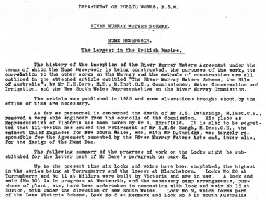
Album - Hume Reservoir Australia Album - Introduction - Part 1, Department of Public Works, N.S.W, 1927
This set of photos is from a leather bound album bearing the inscription "HUME RESERVOIR AUSTRALIA" plus 'The Rt. Hon. L. C. M. S. Amery, P. C., M .P.' all inscribed in gold. It was presented to The Rt. Hon. L. C. M. S. Amery, P. C., M. P, Secretary of State for Dominion Affairs on the occasion of his visit to the Hume Reservoir on 2nd November 1927. This album is of local and national significance as it documents the planning and development of the Hume Reservoir up to 1927. It was the largest water reservoir in the British Empire. The album records the pioneering engineering work that went into its construction.RIVER MURRAY WATERS SCHEME, HUME RESERVOIR THE LARGEST IN THE BRITISH EMPIRE. ' The history of the inception of the River Murray Waters Agreement under the terms of which the Hume Reservoir is being constructed, the purposes of the work, its correlation to the other works on the Murray and the methods of construction are all outlined in the attached article entitled “The River Murray Waters Scheme, the Nile of Australia”, by Mr H.H. Dare, M.E., M.Inst.C.E., Commissioner, Water Conservation and Irrigation, and the New South Wales Representative on the River Murray Commission. The article was published in 1925 and some alterations brought about by the efflux of time are necessary. As far as personnel is concerned, the death of Mr J.S. Dethridge, M.Inst.C.E., removed a very able engineer from the councils of the Commission. His place as Representative of Victoria has been taken by Mr R. Horsfield. It is also to be regretted that ill-health has caused the retirement of Mr E.M. de Burgh, M.Inst.C.E., the eminent Chief Engineer for New South Wales, who, with Mr Dethridge, was largely responsible for the Agreement cemented by the River Murray Waters Acts and, inter alia, for the design of the Hume Dam. The following summary of the progress of work on the Locks might be substituted for the latter part of Mr Dare’s paragraph. Up to the present time six locks and weirs have been completed, the highest in the series being at Torrumberry and the lowest at Blanchetown. Locks No.26 at Torrumberry and No.11 at Mildura were built by Victoria and are in use. A lock and weir (No.10) is in progress at Wentworth, and the necessary camp arrangements, purchase of plant, etc., have been undertaken in connection with lock and weir No.15 at Euston, both under the direction of New South Wales. Lock No.9, which forms part of the Lake Victoria Scheme, Lock No.5 at Renmark and Lock No.3 in South Australia hume reservoir australia, river murray waters scheme -
The Beechworth Burke Museum
Audio - Oral History, Jennifer Williams, Max Suter, 29 June 2000
Mr Max Sutor was born in South Australia. He first began his work as a marine engineer at the Mildura Irrigation Trusts, moving later to the Melbourne Harbour Trusts. After a number of years as an engineer, he moved into farming at Gippsland and joined the prison service several years after during the late 1960s. He was first stationed at Morwell River Prison in South Gippsland, transferring to McLeod Prison in 1972 and finally to Beechworth in 1974 as senior prison and stores officer. He would assist in the organisation, obtaining and distribution of food and medication to prisoners. The prison, at the time, was of medium security and held high security prisoners, with an estimated amount of 108 prisoners to 23 staff. Mr Suter showed a great push in showing humility towards prisoners, wanting to avoid animosity against them by never looking at their records to treat them equally. His choice of kind behaviour towards prisoners had clearly influenced their own, especially during manual labor. The prison had worked cooperatively with a local farm, having their prisoners assist in the farm work. Attitudes inevitably changed positively for several prisoners. Whilst he held no control over their actions at the farm, he still became well trusted and liked amongst the prisoners, as they would continue to go to him for assistance and questions. Mr Suter had also worked as an instigator of finding drugs within each prison he has worked within. This led him to study the variations, and being a member of the Parents and Citizens Association at the high school his children attended, as well as Community Service Director of a Rotary club, he wanted to educate parents in guidance for those unsure on how to conduct actions against such behaviours. From his first seminar, a police surgeon told him that three drug users were found by their parents. This oral history recording was part of a project conducted by Jennifer Williams in the year 2000 to capture the everyday life and struggles in Beechworth during the twentieth century. This project involved recording seventy oral histories on cassette tapes of local Beechworth residents which were then published in a book titled: Listen to what they say: voices of twentieth century Beechworth. These cassette tapes were digitised in July 2021 with funds made available by the Friends of the Burke.Mr Max Suter's account on his time and experience as a senior prison officer at Beechworth Prison is historically and socially significant for the cultural heritage of the region. His recounts of his time working within the prison and out in local parent and community associations held a positive effect on the awareness and behaviours of the Beechworth area, and provides detailed information on the duties and complications working in a 20th century rural prison, as well as the lack of local awareness from adults with young influential children. This oral history account is socially and historically significant as it is a part of a broader collection of interviews conducted by Jennifer Williams which were published in the book 'Listen to what they say: voices of twentieth-century Beechworth.' While the township of Beechworth is known for its history as a gold rush town, these accounts provide a unique insight into the day-to-day life of the town's residents during the 20th century, many of which will have now been lost if they had not been preserved.This is a digital copy of a recording that was originally captured on a cassette tape. The cassette tape is black with a horizontal white strip and is currently stored in a clear flat plastic rectangular container. It holds up 40 minutes of recordings on each side.Max Suterlisten to what they say, beechworth, oral history, burke museum, max suter, beechworth prison, farming, drug awareness -
 Kew Historical Society Inc
Photograph, Marnie McLeod, Floods of the River Yarra at Kew, 1916
The donation was accompanied by the following letter from the donor: "Hi. I found these in with family photos. Taken by family as Mamie McLeod was living in Fellows Street, Kew, so would be near there. Retain (or discard) as you see fit." [Donor's name and address withheld from public view]. To gain an insight into the flood levels at Kew, it is worth reading newspaper accounts of the event. The Age published an article - Valuable Gardens Destroyed at Kew - on 25 September 1916: "VALUABLE GARDENS DESTROYED AT KEW. From the heights of Studley Park, Kew, a splendid view of the flood waters can be obtained, and yesterday afternoon, despite continuous rain, crowds of citizens assembled there to witness the spectacle. There is a vast stretch of water some 300 or 400 yards broad, above the foot bridge connecting Gipps-street, Collingwood, and Studley Park. The river is only about 3 feet from the top of the embankment connecting with the ramp of the bridge on the Studiey Park side. When the upper llood waters come down it is almost a certainty that tne embankment will be submerged and the bridge rendered impassible. Below the bridge the waters again stretch out, and have submerged all the low-lying land on the Collingwood side and invaded the back premises ot the Kodak Co., Phoenix Biscuit Factory, a tannery adjoining thereto, the Shamrock Brewery, and Chinese gardens in the vicinity. At Walmer-street-bridge, at the end of Studley Park, the low-lying land on the Kew side is covered with water to the depth of many feet. Tlie land in question is owned in a great part by Mr Frank Lavers who haa gone in for intense culture on a pretty liberal scale on both the slopes of the hill and on the river flat. On the latter he is cultivating many acres of asparagus, and has at a considerable cost spent three years in preparing the ground and installing an irrigation system, reticulated from the Yan Yean water supply. This year the asparagus was put down, and the plants were in a promising condition. Tlie flood waters are now flowing fast over the land. The crop is ruined, and three years' work and expenditure destroyed. Mr. Laver's private residence fortunately is high above flood level, but two houses he owns off Young-street have been flooded out. Having been warned in time, the tenants removed their furniture hefore the water came down to Mr. Laver's residence, where they themselves have been given accommodation in the meantime. All the river flats in East Kew are under water. One or two low-lying houses have been flooded. Chipperfield's boat shed at Willsmere is nearly covered, and some Chinese gardens in the vicinity are several feet under water."This, and the other three photographs donated of floods in Kew are believed to be the earliest in the collection. Together with our original MMBW River Yarra map showing flood levels, these items, when compared allow researchers to gain a visual perspective of the extent of the flood in 1916. Black and white photograph of flooded trees in Kew with rising dry ground in distance.Inscription on reverse in pencil: "Flood River Yarra Kew Vic"river yarra, kew, floods 1916 -
 Kew Historical Society Inc
Photograph, Marnie McLeod, Floods on the River Yarra at Kew, 1916
The donation was accompanied by the following letter from the donor: "Hi. I found these in with family photos. Taken by family as Mamie McLeod was living in Fellows Street, Kew, so would be near there. Retain (or discard) as you see fit." [Donor's name and address withheld from public view]. To gain an insight into the flood levels at Kew, it is worth reading newspaper accounts of the event. The Age published an article - Valuable Gardens Destroyed at Kew - on 25 September 1916: "VALUABLE GARDENS DESTROYED AT KEW. From the heights of Studley Park, Kew, a splendid view of the flood waters can be obtained, and yesterday afternoon, despite continuous rain, crowds of citizens assembled there to witness the spectacle. There is a vast stretch of water some 300 or 400 yards broad, above the foot bridge connecting Gipps-street, Collingwood, and Studley Park. The river is only about 3 feet from the top of the embankment connecting with the ramp of the bridge on the Studiey Park side. When the upper llood waters come down it is almost a certainty that tne embankment will be submerged and the bridge rendered impassible. Below the bridge the waters again stretch out, and have submerged all the low-lying land on the Collingwood side and invaded the back premises ot the Kodak Co., Phoenix Biscuit Factory, a tannery adjoining thereto, the Shamrock Brewery, and Chinese gardens in the vicinity. At Walmer-street-bridge, at the end of Studley Park, the low-lying land on the Kew side is covered with water to the depth of many feet. Tlie land in question is owned in a great part by Mr Frank Lavers who haa gone in for intense culture on a pretty liberal scale on both the slopes of the hill and on the river flat. On the latter he is cultivating many acres of asparagus, and has at a considerable cost spent three years in preparing the ground and installing an irrigation system, reticulated from the Yan Yean water supply. This year the asparagus was put down, and the plants were in a promising condition. Tlie flood waters are now flowing fast over the land. The crop is ruined, and three years' work and expenditure destroyed. Mr. Laver's private residence fortunately is high above flood level, but two houses he owns off Young-street have been flooded out. Having been warned in time, the tenants removed their furniture hefore the water came down to Mr. Laver's residence, where they themselves have been given accommodation in the meantime. All the river flats in East Kew are under water. One or two low-lying houses have been flooded. Chipperfield's boat shed at Willsmere is nearly covered, and some Chinese gardens in the vicinity are several feet under water."This, and the other three photographs donated of floods in Kew are believed to be the earliest in the collection. Together with our original MMBW River Yarra map showing flood levels, these items, when compared allow researchers to gain a visual perspective of the extent of the flood in 1916. Panoramic view, believed to be looking north towards Fairfield from the Zig-Zag Bridge on the River Yarra. The inscription on the reverese identifies it as taken before 1920.Inscription on reverse in ink "(pre 1920) Flood from Zig-zag bridge Yarra River, Kew Vic."river yarra, kew, floods 1916, zig-zag bridge -
 Kew Historical Society Inc
Photograph, Marnie McLeod, Flood, River Yarra, Kew, 1916
The donation was accompanied by the following letter from the donor: "Hi. I found these in with family photos. Taken by family as Mamie McLeod was living in Fellows Street, Kew, so would be near there. Retain (or discard) as you see fit." [Donor's name and address withheld from public view]. To gain an insight into the flood levels at Kew, it is worth reading newspaper accounts of the event. The Age published an article - Valuable Gardens Destroyed at Kew - on 25 September 1916: "VALUABLE GARDENS DESTROYED AT KEW. From the heights of Studley Park, Kew, a splendid view of the flood waters can be obtained, and yesterday afternoon, despite continuous rain, crowds of citizens assembled there to witness the spectacle. There is a vast stretch of water some 300 or 400 yards broad, above the foot bridge connecting Gipps-street, Collingwood, and Studley Park. The river is only about 3 feet from the top of the embankment connecting with the ramp of the bridge on the Studiey Park side. When the upper llood waters come down it is almost a certainty that tne embankment will be submerged and the bridge rendered impassible. Below the bridge the waters again stretch out, and have submerged all the low-lying land on the Collingwood side and invaded the back premises ot the Kodak Co., Phoenix Biscuit Factory, a tannery adjoining thereto, the Shamrock Brewery, and Chinese gardens in the vicinity. At Walmer-street-bridge, at the end of Studley Park, the low-lying land on the Kew side is covered with water to the depth of many feet. Tlie land in question is owned in a great part by Mr Frank Lavers who haa gone in for intense culture on a pretty liberal scale on both the slopes of the hill and on the river flat. On the latter he is cultivating many acres of asparagus, and has at a considerable cost spent three years in preparing the ground and installing an irrigation system, reticulated from the Yan Yean water supply. This year the asparagus was put down, and the plants were in a promising condition. Tlie flood waters are now flowing fast over the land. The crop is ruined, and three years' work and expenditure destroyed. Mr. Laver's private residence fortunately is high above flood level, but two houses he owns off Young-street have been flooded out. Having been warned in time, the tenants removed their furniture hefore the water came down to Mr. Laver's residence, where they themselves have been given accommodation in the meantime. All the river flats in East Kew are under water. One or two low-lying houses have been flooded. Chipperfield's boat shed at Willsmere is nearly covered, and some Chinese gardens in the vicinity are several feet under water."This, and the other three photographs donated of floods in Kew are believed to be the earliest in the collection. Together with our original MMBW River Yarra map showing flood levels, these items, when compared allow researchers to gain a visual perspective of the extent of the flood in 1916. Small black and white photograph of flooded trees in Kew.Inscription on reverse in ink "Flood R. Yarra Kew Vicriver yarra, kew, floods 1916 -
 Surrey Hills Historical Society Collection
Photograph, Subdivision sale of Black's Mont Albert farm in 1924, 1924
Photo was taken in 1924 when the land was subdivided. Black's dairy farm occupied the area just east of Hamilton Street to near Elgar Road. It was subdivided into 88 house allotments along Churchill Street, Bruce Street, Black Street, Proudfoot Street and View Street. The solicitors were Proudfoot & Horton, 360 Collins Street; estate agents were Duncan & Weller, 29 Queen Street. The real estate subdivision notice on the SLV website states that Neil Black had been the owner for 50 years. To date no trace of a Neil Black has been found. Box Hill rate books simply give BLACK as the owner in 1877 (no first name); the entry for 1878-1884 states Robert Black. The 1909 electoral roll has entries for Mont Albert Road for Robert Black (farmer), Thomas Black (carter) & Elizabeth Black (HD). The 1912 electoral roll has entries for Mont Albert Road for Robert Black (farmer), Thomas Black (labourer), John Arthur Black (carter) & Elizabeth Black (HD). Robert Black died in 1920 (b. 1836) and is buried in Box Hill Cemetery (CE-*-0057). His parents were John and Margaret Black. He married Lizzie Foley in 1878. She was the daughter of Margaret & John Foley, born in 1859. She died in 1902 aged 43 years and is buried in the same grave, although the cemetery records record her age as 0 years (presumably as no age or date of birth were given at the time of burial). Children: 1. James Hughbert (1880-1954) 2. John Arthur (1881-1959) 3. Alice (1882-1883) - died aged 6 months 4. Laura Elizabeth (1883-1951) 5. Thomas (1885-1965) 6. Isabella (1887-1963) 7. Eleanor (1889-1963) 8. Ada Maud (1890-1968) 9. Robert (1892-1930). BDM Victoria states places of birth as Box Hill, Surrey Hills or Mont Albert. Many of the family are buried in Box Hill Cemetery. None of the girls appear to have married. Communication from a descendant of John Arthur Black gives the following: "John Arthur Black, son of Robert & Lizzie Foley, married Gladys Anne Layton had 4 children, Robert, Elenore, Marion (Follett) & Annie; they had farm on Stud Road, Dandenong where they milked 30 cows that he retired to after being a earth-moving contractor with draft horses and dug irrigation ditches around Shepparton." This is important as documentation of the area's transformation from farming land to residential land use.Black and white photo of a large 3-poled tent in an area of flat land with eucalypts in the background. There is a large crowd of people, mainly men but also women and children. There are also 3 cars to the RHS.black's dairy farm, dairying, farms, churchill street, black street, proudfoot street, bruce street, view street, neil black, proudfoot & horton, duncan & weller, robert black, lizzie black, lizzie foley, james hubert black, john arthur black, alice black, laura elizabeth black, thomas black, isabella black, eleanor black, ada maud black, robert black jnr, box hill cemetery, land sales -
 Surrey Hills Historical Society Collection
Photograph, Norman Carter, Part of Black's dairy farm in Mont Albert in the 1920s, 1920s
Photo is likely to have been taken pre-1924 when the land was subdivided. Donor information is that this was taken from a home in Churchill Street, Mont Albert; it would be looking south towards Mont Albert Road. Black's dairy farm occupied the area just east of Hamilton Street to near Elgar Road. It was subdivided into 88 house allotments along Churchill Street, Bruce Street, Black Street, Proudfoot Street and View Street. The solicitors were Proudfoot & Horton, 360 Collins Street; estate agents were Duncan & Weller, 29 Queen Street. The real estate subdivision notice on the SLV website states that Neil Black had been the owner for 50 years. To date no trace of a Neil Black has been found. Box Hill rate books simply give BLACK as the owner in 1877 (no first name); the entry for 1878-1884 states Robert Black. The 1909 electoral roll has entries for Mont Albert Road for Robert Black (farmer), Thomas Black (carter) & Elizabeth Black (HD). The 1912 electoral roll has entries for Mont Albert Road for Robert Black (farmer), Thomas Black (labourer), John Arthur Black (carter) & Elizabeth Black (HD). Robert Black died in 1920 (b. 1836) and is buried in Box Hill Cemetery (CE-*-0057). His parents were John and Margaret Black. He married Lizzie Foley in 1878. She was the daughter of Margaret & John Foley, born in 1859. She died in 1902 aged 43 years and is probably buried in the same grave, although the cemetery records record her age as 0 years. Children: 1. James Hughbert (1880-1954) 2. John Arthur (1881-1959) 3. Alice (1882-1883) - died aged 6 months 4. Laura Elizabeth (1883-1951) 5. Thomas (1885-1965) 6. Isabella (1887-1963) 7. Eleanor (1889-1963) 8. Ada Maud (1890-1968) 9. Robert (1892-1930). BDM Victoria states places of birth as Box Hill, Surrey Hills or Mont Albert. Many of the family are buried in Box Hill Cemetery. None of the girls appear to have married. Communication from a descendant of John Arthur Black gives the following: "John Arthur Black, son of Robert & Lizzie Foley, married Gladys Anne Layton had 4 children, Robert, Elenore, Marion (Follett) & Annie; they had farm on Stud Road, Dandenong where they milked 30 cows that he retired to after being a earth-moving contractor with draft horses and dug irrigation ditches around Shepparton." This is important as documentation of the area's early farming land use.Black and white photo of a paddock with cows and sheep grazing. On the horizon is a simple cottage with a small veranda and 2 chimneys and scattered trees.black's dairy farm, dairying, farms, churchill street, black street, proudfoot street, bruce street, view street, neil black, proudfoot & horton, duncan & weller, robert black, lizzie black, lizzie foley, james hubert black, john arthur black, alice black, laura elizabeth black, thomas black, isabella black, eleanor black, ada maud black, robert black jnr, box hill cemetery -
 Bendigo Military Museum
Photograph - PHOTOGRAPHS WW1, Originals: 1915
The photos in the collection relate to Thomas Robert JONES No 1982 AIF. Refer Reg No 1377 for his service details..1) - .22) Photos, black / white, showing men, training, the desert, Dardanelles, Turkish prisoners, leaving Egypt. .23) - .44) Enlargement copies of photos .1) - .22), sepia.Hand written on the rear in pen: .1) Housing parade on the desert Egypt, bugler band 6th Battalion. .2) Australian Field Artillery exercising horses near the pyramids. .3) Some of the buglers of the 6th Battalion with their identification disks as eyeglasses. .4) Serving out rations. .5) 6th Battalion having a short halt during a route march on the desert. .6) 18 Pounder Field Gun Australian Artillery. .7) 'Come to the Cook House Door' 6th Battalion AIF. .8) Lieut WATSON - Machine Gun being vaccinated by Lieut BALFE A Coy. Both these Officers are amongst the fallen. .9) 6th Battalion AIF preparing to leave Mena Camp for the Dardanelles. .10) A Turk captured on the morning of 25th April 1915 on board the troop ship Galeka. .11) Wounded alongside of hospital ship Galeka. .12) HMS Vengeance at the Dardanelles. .13) Hospital ship Sudan off Gaba Tepe. .14) Observation balloon off Cape Helles. .15) British Destroyer off Cape Helles. .16) Cape Helles, Dandanelles. .17) Turkish prisoners captured at the Suez _ _ _ Barracks, Cairo. .18) Turkish prisoners. .19) <> Guides near pyramids Mena. .20) Method of irrigation on the Nile, Egypt. .21) Going on leave into Cairo. .22) View of Cairo mosques in foreground taken from the Citadel. .23) - .44) On rear in stamp form: Dennis Major, 7 Bancroft St Bendigo Vic 3550. Tel & fax 03 544 2445 photography, military, ww1 -
 The Beechworth Burke Museum
Photograph, c1885
This carte de visite was taken of Hiram Crawford in fire brigade uniform taken by Stewart & CO., Melbourne. Hiram Crawford was Captain of the Beechworth Volunteer Fire Brigade for twenty-five years. Hiram arrived in Australia at the age of 21 in August 1853. He mined for short time at Back Creek Bendigo, then went to the Ovens where he sought gold in Spring Creek, Buckland and 3 Mile. After moving to Albury for 18 months he married Anna, moved to Woolshed and was there for two years mining gold. After discovering his fortune he formed Crawford and Co. Coaching Lines in Beechworth in late 1856. It was this company which became the longest surviving coaching business in the State of Victoria. Hiram and Anna had two daughters. Anna died in March 1862 and in May Hiram left from Melbourne to return to the United States on a visit. Hiram married Martha Foster during this visit and returned to Australia in March 1863. With his coach line established, and leaving it under management, he moved around the north east of Victoria establishing and building shops and the Star Hotel and Theatre in Chiltern in 1866. In 1869 he moved to Melbourne for a few years in which time he built the Eastern Arcade in Bourke Street. In 1876 the family returned to Beechworth for a few years eventually moving to Everton where Hiram grew hops, tobacco, fruit trees and established the largest lemon orchard at that time in Australia. Hiram spent a considerable amount of his time helping to develop the North East of the State not only in his private endeavours but as a public figure. Among his many achievements a few are listed - Councillor, Mayor of Chiltern and Beechworth, President of the Shire on two occasions, Director of many mining companies, Inaugural Chairman and Director of the Beechworth Gas Company roles he held for over 20 years, Foundation member of Beechworth Pottery, Committee member of the Beechworth Hospital, Captain/Superintendent of the Vol. Fire Brigade for over 20 years, Foundation, Life member of and on the State Fire Brigade Board for many years, President of the North Eastern Railway League in Chiltern On a personal level Hiram was involved in lodges including St. Johns #14, Beechworth. and had several grazing properties in the Ovens area. He had the Forest Park Hotel at Carboor, the Creamery at Carboor, and grazing land on which the Milawa Creamery was built during his ownership. He was a committee member for 3 committees duirng the 1888 International Exhibition in Melbourne. Hiram had many voyages around the world studying irrigation, hop growing, tobacco growing and drying. During his retirement in Melbourne Hiram purchased many properties in the Elsternwick area and acted as an Estate Agent. After the death of his second wife Martha, Hiram married for the third time in 1912 to Sophia Maude Heatley. Crawford and Co continued until 1921. [Taken from HighCountryHeritage.com.au]Black and white reproduction of a studio portrait of Hiram Crawford in fire brigade uniform, printed on gloss photographic paper and bordered with a white frame.Badge on uniform sleeve reads: CAPTAIN / BVFB Obverse: AB/ Stewart & CO./ Melbourne Reverse: Hiram Collection/ BMM2435burke museum, emergency services, beechworth, carte de visite, black and white, fire brigade, hiram crawford, stewart & co., melbourne.