Showing 1133 items matching "kew east"
-
![High Street, East Kew [looking west], 1977](/media/collectors/550653872162f11fb04854aa/items/586f8bbfd0ce0e07f06d22ed/item-media/586f8c3ad0ce0e07f06d44cc/item-fit-380x285.jpg) Kew Historical Society Inc
Kew Historical Society IncPhotograph, High Street, East Kew, 1977
... High Street, East Kew... people, places and objects within the suburbs of Kew and Kew East...View from junction of High and Strathalbyn Sts., Kew East... people, places and objects within the suburbs of Kew and Kew East ...The Kew Historical Society's Pictures Collection is comprised of photographs and original works of art. The photographs include original (mainly) images dating from the 1870s to the present. A number of these photographs derive from the former City of Kew's Civic Collection while others are the work of amateur and professional photographers. Most of the images in the collection depict people, places and objects within the suburbs of Kew and Kew East. Other photographs depict other locations in Melbourne and Victoria. A number of the photographs are of statewide and/or national significance.View from junction of High and Strathalbyn Sts., Kew East, looking approximately west toward Cemetery, October 1977. Inscription reverse: "KH-72. View from junction of High St. & Strathalbyn Sts, Kew E. Looking approx. west, towards Cemetery. October 1977."high street -- kew (vic.), streetscapes -- kew (vic.) -
![East Kew Women’s Club: Twenty Years: 20/7/1945 [to] 30/7/1965](/media/collectors/550653872162f11fb04854aa/items/582d1076d0cdd12558de8ee9/item-media/58356ff7d0cdd10cccdd1152/item-fit-380x285.jpg) Kew Historical Society Inc
Kew Historical Society IncBooklet, East Kew Women’s Club: Twenty Years
... East Kew Women’s Club: Twenty Years...east kew women's club...The East Kew Women’s Club was formed on 20 July 1945...Stapled self-published history of the East Kew Women’s Club... The East Kew Women’s Club was formed on 20 July 1945 ...The East Kew Women’s Club was formed on 20 July 1945 as an experiment amongst local women, who felt that there was a need for some organised group to give full scope to their various interests and hobbies. In the beginning, they met at the house of their founder, Mrs Eric Thake, 48 Harp Road, East Kew, but the growth and interest was so rapid that it was soon necessary to find a larger meeting place, so the group moved to the Harrier’s Pavilion in Victoria Park, Kew. At the fifth meeting of the group, a committee was formed, and a constitution adopted on 4 December 1945.The Club was aimed to be non-political, non-sectarian and open to women from any locality. The Club’s motto was “To Help others, Improve Ourselves, and Foster the Community Spirit”. The first twenty years of the Club was recorded in a small, nine-page publication “East Kew Women’s Club : Twenty Years 20-7-1945 - 30-7-1965”.Following the closure of the Club in 1973, after twenty-eight years, its records were deposited with the Kew Historical Society and are thus available for research into the history of women’s groups in the post war period in Australia. The Society holds the Club’s Minute Books of Meetings (1953-73), Attendance Registers (1959-73), Visitors Book, and sundry items of print ephemera published by the Club.Stapled self-published history of the East Kew Women’s Club, entitled - "Twenty Years 20/7/1945 - 30/7/1965". 9pp & covers.east kew women's club, community clubs -- kew (vic.) -- histories -
 Kew Historical Society Inc
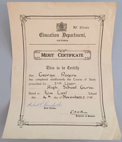
Certificate - School Certificate, Education Department (Victoria), Merit Certificate, George Rogers, Kew East School, 1941, 1941
... Merit Certificate, George Rogers, Kew East School, 1941... prescribed for 2nd Year High School Course, date dat Kew East School... prescribed for 2nd Year High School Course, date dat Kew East School ...George Rogers of Park Crescent, Kew, was the brother of John Rogers, the donor, and the son of Dorothy Rogers.This work forms part of the collection assembled by the historian Dorothy Rogers, that was donated to the Kew Historical Society by her son John Rogers in 2015. The manuscripts, photographs, maps, and documents were sourced by her from both family and local collections or produced as references for her print publications. Many were directly used by Rogers in writing ‘Lovely Old Homes of Kew’ (1961) and 'A History of Kew' (1973), or the numerous articles on local history that she produced for suburban newspapers. Most of the photographs in the collection include detailed annotations in her hand. The Rogers Collection provides a comprehensive insight into the working habits of a historian in the 1960s and 1970s. Together it forms the largest privately-donated collection within the archives of the Kew Historical Society.Education Department of Victoria Merit CertificateEducation Department of Victoria - This is to Certify that George Rogers has completed satisfactorily the course of study prescribed for 2nd Year High School Course, date dat Kew East School this 14th of November A.D. 1941merit certificate, george rogers, education, certificate -
 Kew Historical Society Inc
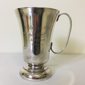
Award - Silver Plate Trophy Cup, East Kew B.S.C, 1958-9
... east kew baseball club...East Kew S.B.C. / Many thanks / A Miers / 1958-9...East Kew B.S.C..... arthur henry miers trophies east kew baseball club baseball ...Arthur Henry Miers played for cricket, football and baseball teams in Kew for a number of decades in the first half of the twentieth century. He was born on 22 November 1901, the son of Rodolph Theophilus Miers (1874-1951) and Margaret Frances (Margaretta) Fry (1875-1958). He had two brothers, Rodolph Cecil Miers (1904-80) and Charles Wilfred Miers (1906-88), and a sister Marjorie Elizabeth Miers (1911-84). Arthur Miers died in Kew on 25 January 1966, and after his body was cremated, his body was interred in the Mausoleum of Boroondara General (Kew) Cemetery.Inscribed trophy cup from 1958-9East Kew S.B.C. / Many thanks / A Miers / 1958-9arthur henry miers, trophies, east kew baseball club, baseball trophies -
 Ballarat Heritage Services
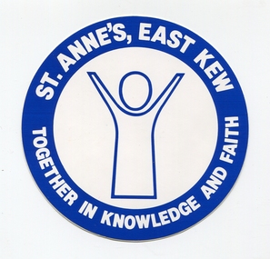
Photograph, St Anne's East Kew Sticker, c1980, c1980
... St Anne's East Kew Sticker, c1980...St Anne's East Kew...Blue and white sticker of St Anne's Primary School in East...Sticker St Anne's East Kew education Blue and white sticker ...Blue and white sticker of St Anne's Primary School in East Kew. sticker, st anne's east kew, education -
 Kew Historical Society Inc
Plan - Subdivision Plan, Erin Heights Estate, East kew, 1917
... Erin Heights Estate, East kew...subdivision plans - east kew... the route of the Outer Circle Railway. This Railway reached Kew East... of the City of Melbourne. Most of these are of Kew, Kew East ...Pru Sanderson, in her groundbreaking ‘City of Kew Urban Conservation Study : Volume 2 - Development History’ (1988), summarised the periods of urban development and subdivisions of land in Kew. The periods that she identified included 1845-1880, 1880-1893, 1893-1921, 1921-1933, 1933-1943, and Post-War Development. These periods were selected as they represented periods of rapid growth or decline in urban development. An obvious starting point for Sanderson’s groupings involved population growth and the associated economic cycles. These cycles also highlighted urban expansion onto land that was predominantly rural, although in other cases it represented the decline and breakup of large estates. A number of the plans in the Kew Historical Society’s collection can also be found in other collections, such as those of the State Library of Victoria and the Boroondara Library Service. A number are however unique to the collection.The Kew Historical Society collection includes almost 100 subdivision plans pertaining to suburbs of the City of Melbourne. Most of these are of Kew, Kew East or Studley Park, although a smaller number are plans of Camberwell, Deepdene, Balwyn and Hawthorn. It is believed that the majority of the plans were gifted to the Society by persons connected with the real estate firm - J. R. Mathers and McMillan, 136 Cotham Road, Kew. The Plans in the collection are rarely in pristine form, being working plans on which the agent would write notes and record lots sold and the prices of these. The subdivision plans are historically significant examples of the growth of urban Melbourne from the beginning of the 20th Century up until the 1980s. A number of the plans are double-sided and often include a photograph on the reverse. A number of the latter are by noted photographers such as J.E. Barnes.The Erin Heights Estate in Kew included just seven lots in in Valerie Street. These were all that remained of this wartime subdivision, the other 11 allotments on Balfour and Belford Roads having already been sold. Balfour Road was to be only a temporary name as the street is currently called Windella Avenue. Now, the parkland opposite the subdivision is the reserve created from the route of the Outer Circle Railway. This Railway reached Kew East in 1925, but had been planned as far back as 1873. The development focuses on the benefits of living in Kew: being at the highest of Kew’s ‘suburbs’; being a good residential area; its rapid growth; and the proximity of the Kew East tram in High Street. In 1917, the electric tramline only extended to a terminus at the Harp of Erin hotel. The terminus is clearly represented on the plan.subdivision plans - east kew, erin heights estate -
 Kew Historical Society Inc
Plan - Subdivision Plan, Winton Estate, East Kew : Sale of 10 Building Blocks, 1920
... Winton Estate, East Kew : Sale of 10 Building Blocks...subdivision plans - east kew...Subdivision plan for the so-called Winton Estate in East... subdivision plans - east kew subdivision plans - kew Subdivision plan ...The Kew Historical Society's map collection includes a substantial number of real estate subdivision plans, mainly of Kew but also of surrounding suburbs in Melbourne. Most of the subdivision plans date from the 1920s and 1930s when the districts old homes and local farmland were being split up to accommodate residential growth in the postwar period. These early plans were assembled by a local firm, Jas R Mather & McMillan, which had an office in Cotham Road. Many of the plans, and sometimes photos, were annotated by the agents.Subdivision plans are historically important documents used as evidence for the growth of suburbs in Australia. They frequently provide information about when the land was sold as well as evidence relating to surveyors and real estate and financial agents. The numerous subdivision plans in the Kew Historical Society's collection represent working documents, ranging from the initial sketches made in planning a subdivision to printed plans on which auctioneers or agents listed the prices for which individual lots were sold. In a number of cases, the reverse of a subdivision plan in the collection includes a photograph of a house that was also for sale by the agent. These photographs provide significant heritage information relating house design and decoration, fencing and household gardens.The photograph may also be aesthetically significant depending on the importance of the photographic atelier.Subdivision plan for the so-called Winton Estate in East Kew. The Estate comprised 10 lots facing Simpson Street and Campbell Street. The estate was auctioned by Jas. R. Mathers, Son and McMillan. campbell street, simpson street, hunter street, normanby road - kew, subdivision plans - east kew, subdivision plans - kew -
 Kew Historical Society Inc
Plan - Subdivision Plan, Shop Sites, East Kew, c.1927
... Shop Sites, East Kew...subdivision plans - east kew... and Station Street. The plan shows this stretch of High Street, East... and household gardens. subdivision plans - east kew high street - east ...Subdivision plans are historically important documents used as evidence of the growth of suburbs in Australia. They frequently provide information about when the land was sold on which a built structure was subsequently constructed as well as evidence relating to surveyors and real estate and financial agents. The numerous subdivision plans in the Kew Historical Society's collection represent working documents, ranging from the initial sketches made in planning a subdivision to printed plans on which auctioneers or agents listed the prices for which individual lots were sold. In a number of cases, the reverse of a subdivision plan in the collection includes a photograph of a house that was also for sale by the agent. These photographs provide significant heritage information relating house design and decoration, fencing and household gardens.This is one of a small number of subdivision plans for commercial property in the collection. The subdivision proposed to create six shop sites in High Street between the Harp of Erin and Station Street. The plan shows this stretch of High Street, East Kew already lined with shops that include the hotel on the corner, the new State Savings Bank, a dentist’s surgery and Lambert’s Store. The High Street Tram was to reach Burke Road in 1925, so the proposed subdivision must postdate that event, and the opening of the Bank in 1926.subdivision plans - east kew, high street - east kew -
 Kew Historical Society Inc
Photograph, Kew looking East to Deepdene, c.1905
... Kew looking East to Deepdene...Kew looking east towards Deepdene. Before 1909. ... looking east towards Deepdene. Before 1909. Kew looking East ...Kew looking east towards Deepdene. Before 1909. The reverse of the photograph includes an analysis of the photo and the places that can be seen within it (eg Deepdene Station, first Deepdene School, Burke Road etc)deepdene, farming (kew) -
 Kew Historical Society Inc
Photograph - William John Lamb : Station Master, East Kew Railway Station
... William John Lamb : Station Master, East Kew Railway...East Kew railway station... worked as station master at East Kew connected the Oakleigh... worked as station master at East Kew connected the Oakleigh ...William John Lamb (1878-1958) was born in Ballarat, the second oldest of eight children. His father was born in Scotland and had later migrated to Australia. William Lamb lived in Bright Street, Kew, with his daughter. This was possibly his family home. He died in 1958 aged 80. The Outer Circle Railway on which he worked as station master at East Kew connected the Oakleigh and Fairfield Park Stations. The East Kew Station was on the northern end of Harp Road, Kew, near the junction of High Street and Harp Road.outer circle railway, east kew railway station, station masters - outer circle railway -
 Kew Historical Society Inc
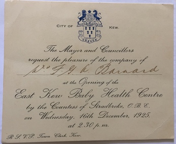
Document (item) - Invitation, City of Kew, Opening of the East Kew Baby Health Centre, 1925
... Opening of the East Kew Baby Health Centre...east kew baby health centre... the Opening of the East Kew Baby Health Centre in 1925.... invitations -- kew (vic) mrs fga barnard east kew baby health centre ...The Municipality of Kew (1860-1863), the Borough of Kew (1863-1910), the Town of Kew (1910-1921) and the City of Kew (1921-1994) were local government instrumentalities in the State of Victoria. In 1994, the City of Kew was amalgamated, together with the former Cities of Camberwell and Hawthorn, into the new City of Boroondara (1994- ). Like other local government entities of the period, Kew was administered by town clerks. The two notable town clerks in Kew's history were H. H. (Henry Hirst) Harrison (1868-1955) and W. D. (William Dickie) Birrell (1899-1974). Harrison was appointed to the position in 1901 and retired in 1938 after 37 years. Birrell, appointed Acting Town Clerk in 1921, became Town Clerk in 1938, following Harrison's retirement. He continued in this role until his retirement in 1966.This card is part of an historically significant civic collection, containing hundreds of separate invitations, documents, greeting cards, programmes and tickets issued and/or collected by successive town clerks. Items in the collection illuminate the political, social and cultural history of the district. As a continuous record, ranging across most decades of the Twentieth Century, they reveal changing tastes in design, values and relationships in the history of local government in Victoria.CITY OF KEW / THE MAYOR AND COUNCILLORS / REQUEST THE PLEASURE OF THE COMPANY OF / Mrs FGA Barnard / AT TH EOPENING OF THE / EASK KEW BABY HEALTH CENTRE / civic invitations -- kew (vic), mrs fga barnard, east kew baby health centre, countess of stradbroke, social services -- kew (vic.) -
 Kew Historical Society Inc
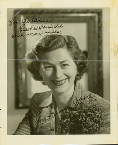
Photograph - Geraldine Ward, 1960
... east kew women's club...The East Kew Women’s Club was formed on 20 July 1945... and addressed to the Ladies of the East Kew Women's Club....Obverse: [Signed in ink] For the ladies of the East Kew... The East Kew Women’s Club was formed on 20 July 1945 ...The East Kew Women’s Club was formed on 20 July 1945 as an experiment amongst local women, who felt that there was a need for some organised group to give full scope to their various interests and hobbies. In the beginning, they met at the house of their founder, Mrs Eric Thake, 48 Harp Road, East Kew, but the growth and interest was so rapid that it was soon necessary to find a larger meeting place, so the group moved to the Harrier’s Pavilion in Victoria Park, Kew. At the fifth meeting of the group, a committee was formed, and a constitution adopted on 4 December 1945.The Club was aimed to be non-political, non-sectarian and open to women from any locality. The Club’s motto was “To Help others, Improve Ourselves, and Foster the Community Spirit”. The first twenty years of the Club was recorded in a small, nine-page publication “East Kew Women’s Club : Twenty Years 20-7-1945 - 30-7-1965”.Portrait photograph of Geraldine Ward, signed, dated and addressed to the Ladies of the East Kew Women's Club.Obverse: [Signed in ink] For the ladies of the East Kew Women's Club with warm wishes, Geraldine Ward 1960." [Reverse annotated] Presented to Society with Minute Books from East Kew Women's Club. / Signed Geraldine Ward across photo / KH-217 / {Stamped] Hand Hasenpflug Illustrative Photography, 62 Swanston Street, Melbourne, Phone CENT 2187.clubs -- kew east (vic.), east kew women's club, glenda ward -
 Kew Historical Society Inc
Archive (Sub-series) - Subject File, East Kew Community Bank, 1958
... East Kew Community Bank...east kew community bank... sources. kew (vic) - history bedigo bank - kew east (vic) east kew ...Various partiesReference, Research, InformationSecondary Values (KHS Imposed Order)Small subject file containing two bank produced promotional pamphlets.kew (vic) - history, bedigo bank - kew east (vic), east kew community bank, kew (vic) - commerce and financekew (vic) - history, bedigo bank - kew east (vic), east kew community bank, kew (vic) - commerce and finance -
 Bendigo Military Museum
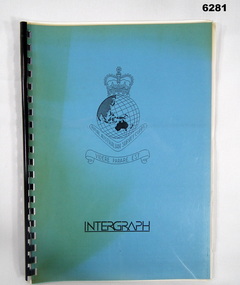
Administrative record - Intergraph Maintenance Programme for Project "Newhart", Intergraph, Suite 6, 1401 Burke Rd, Kew East 3102, 28 August 1992
... Intergraph, Suite 6, 1401 Burke Rd, Kew East 3102... "Newhart" Intergraph, Suite 6, 1401 Burke Rd, Kew East 3102 ...Intergraph Maintenance by Replacement Proposal (MBR) is the Terms and conditions for the implementation of "Project Newhart" ad the ongoing maintenance of the Automap 2 System. The Document was prepared by Intergraph's Account Manager, Norman John McMurtrie and addressed to LtCol R McHenry, CO Army Survey Regiment.A4 Booklet, Plastic cover, Blue front cover and white rear, Plastic ring binder, RASvy Badge and Text "Intergraph". Pages inserted loose and not secured, includes diagrams and text.royal australian survey corps, rasvy, fortuna, army survey regiment, army svy regt, asr -
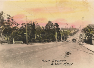 Kew Historical Society Inc
Postcard - High Street, East Kew, c.1927
... High Street, East Kew... of the photo is now Kew East. High Street progresses through a number...Small, colorised real photo postcard of High Street, East... is now Kew East. High Street progresses through a number ...High Street, Kew is the main Road in Kew. It was once also known as Bulleen Road, or Main Street. This section of the road is in Kew, although the narrow section on the right hand side of the photo is now Kew East. High Street progresses through a number of significant road junctions: beginning at Barkers Road; progressing through the intersection of Studley Park Road, Denmark Street and Princess Street at Kew Junction; branching left at the junction with Cotham Road; before reaching the junction with Valerie Street and Harp Road. It reaches its end at the junction of Burke Road, Kilby Road, Bulleen Road and High Street itself. An early photograph of this iconic Memorial that locates it in its context. Small, colorised real photo postcard of High Street, East Kew. Electric light poles line the road. Victoria Park is on the left and further on the horizon is the Boroondara General Cemetery.high street -- kew (vic.), victoria park, tram lines -- kew (vic.) -
 Kew Historical Society Inc
Photograph - View from the Verandah of 52 Frater Street, Kew
... 52 Frater Street -- Kew East(Vic.)...View from 52 Frater Street, Kew East ... the second half of the 1940s. 52 Frater Street -- Kew East(Vic ...52 Frater Street was the home of the Coade family from the second half of the 1940s. View from 52 Frater Street, Kew East 52 frater street -- kew east(vic.), coade family -
 Kew Historical Society Inc
Plan - Subdivision Plan, Jas R Mathers Son & McMillan, East Kew Tramway Estate, 1915
... East Kew Tramway Estate...east kew tramway estate...The East Kew Tramway Estate was a subdivision of two... of the City of Melbourne. Most of these are of Kew, Kew East ...Pru Sanderson, in her groundbreaking ‘City of Kew Urban Conservation Study : Volume 2 - Development History’ (1988), summarised the periods of urban development and subdivisions of land in Kew. The periods that she identified included 1845-1880, 1880-1893, 1893-1921, 1921-1933, 1933-1943, and Post-War Development. These periods were selected as they represented periods of rapid growth or decline in urban development. An obvious starting point for Sanderson’s groupings involved population growth and the associated economic cycles. These cycles also highlighted urban expansion onto land that was predominantly rural, although in other cases it represented the decline and breakup of large estates. A number of the plans in the Kew Historical Society’s collection can also be found in other collections, such as those of the State Library of Victoria and the Boroondara Library Service. A number are however unique to the collection.The Kew Historical Society collection includes almost 100 subdivision plans pertaining to suburbs of the City of Melbourne. Most of these are of Kew, Kew East or Studley Park, although a smaller number are plans of Camberwell, Deepdene, Balwyn and Hawthorn. It is believed that the majority of the plans were gifted to the Society by persons connected with the real estate firm - J. R. Mathers and McMillan, 136 Cotham Road, Kew. The Plans in the collection are rarely in pristine form, being working plans on which the agent would write notes and record lots sold and the prices of these. The subdivision plans are historically significant examples of the growth of urban Melbourne from the beginning of the 20th Century up until the 1980s. A number of the plans are double-sided and often include a photograph on the reverse. A number of the latter are by noted photographers such as J.E. Barnes.The East Kew Tramway Estate was a subdivision of two separate parcels of land between Adeney Avenue and Normanby Road. The larger section included 54 lots facing Adeney Avenue, Argyle Road, and Campbell, Hunter and Wishart Streets. [Hunter and Wishart Streets were created as part of the subdivision.] A further 17 allotments faced Normanby Road, Hubert and Campbell Streets. [The name of Hubert Street was later to be changed to Cecil Street.] The promotion of the sale referred to the advantages of living between two tram routes, in High Street and Cotham Road. On the plan, quaintly drawn trams mark these routes. Also on the plan is the route of part of the Outer Circle [Railway] Line.east kew tramway estate, subdivision plans - east kew -
 Melbourne Tram Museum
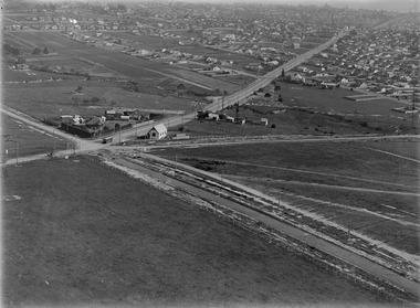
Photograph - Digital Image, Kevin O'Reilly, "Kew Burke Rd' looking at the East Kew Tram terminus, c1925
... "Kew Burke Rd' looking at the East Kew Tram terminus... East Kew... at the East Kew Tram terminus with the city skyline in the background... Trams tramways Kew Burke Rd East Kew Doncaster Rd Image from CD ...Image from CD (Compact Diskette for use in computers) - see Reg Item 135. Image titled "Kew Burke Rd' on CD, of looking at the East Kew Tram terminus with the city skyline in the background, c1925. Photo published in the Bellcord No. 16, Oct. 2012. From the article with the photograph; The terminus was located at the intersection of High St, Burke, Kilby and Doncaster Roads. We are at the outer edges of Melbourne’s suburbia at the time, unlike the current tram terminus of today. Burke Road, north of Doncaster Road is clearly under construction in preparation for the new river crossing. The vacant block of land in the foreground will remain so for another ten years or so. In 1960 the new Dickens Supermarket was built on this site and the intersection became known locally as Dickens Corner. The narrow track on the left hand side of the photo is Doncaster Road. The tram at the terminus is a straight-sill single trucker of one of the G, K, Q or R classes. It is finished in the late MMTB chocolate and cream livery. A cable grip car body has been placed as a tram shelter at the terminus. The church was subsequently relocated to Francis Street Yarraville where it still stands today as a private residence. Behind the large hedge on the south side of High Street is Smith’s Dairy. Part of this land would be sold to the MMTB for a planned new tram depot Behind the large hedge on the south side of High Street is Smith’s Dairy. Part of this land would be sold to the MMTB for a planned new tram depot but by the early 1960s it was transferred to the Education Department for construction of the Kew High School. The last portion of the dairy closed in the 1970s.trams, tramways, kew, burke rd, east kew, doncaster rd -
 Kew Historical Society Inc
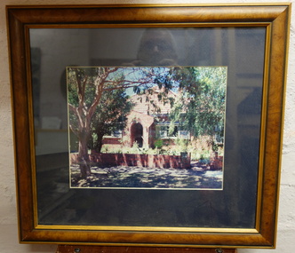
Photograph - Framed Photograph, Red Brick House
... houses - kew - kew east... in Kew or Kew East... houses - kew - kew east Nil Framed and glazed small photograph ...Unidentified house. KHS welcomes viewers to identify the locationFramed and glazed small photograph of a red brick house in Kew or Kew EastNilhouses - kew - kew east -
Kew Historical Society Inc
Book, Brief History 1925-1975, East Kew Presbyterian Church, 1970
... Brief History 1925-1975, East Kew Presbyterian Church...east kew presbyterian church... (vic.) presbyterian church -- kew (vic.) east kew presbyterian ...non-fictionchurches -- kew (vic.), presbyterian church -- kew (vic.), east kew presbyterian church -
 Kew Historical Society Inc
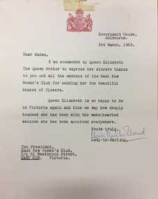
Document, Letter to the President of the East Kew Women's Club from the Lady in Waiting to Queen Elizabeth The Queen Mother, 1958
... Letter to the President of the East Kew Women's Club from...east kew women's club...Letter sent to the President of the East Kew Women's Club... of the Club had sent. east kew women's club quuen elizabeth the queen ...The Queen Mother was undertaking a Royal Tour to Australia in 1958. The letter was in response to a basket of flowers that the members of the Club had sent. Letter sent to the President of the East Kew Women's Club from Olivia Mulholland, Lady-in-Waiting to Queen Elizabeth the Queen Mother, thanking the members for a basket of flowers that they had sent to the Queen Mother. The letter is accompanied by a photograph of the flowers (1974.0017b). The letter, on Government House letterhead is dated 3rd March 1958. The item includes the letter and the envelope. [The photograph of the flowers can be viewed as item 1973.0017b].east kew women's club, quuen elizabeth the queen mother, 1958 royal tour (victoria) -
 Kew Historical Society Inc
Plan - Subdivision Plan, Oswinia Estate, East Kew, c.1925
... Oswinia Estate, East Kew...subdivision plans - east kew...The ‘Oswinia Estate’ subdivision in East Kew was planned... plans - east kew oswinia estate high street, glass street, namur ...Prue Sanderson, in her groundbreaking ‘City of Kew Urban Conservation Study : Volume 2 - Development History’ (1988), summarised the periods of urban development and subdivisions of land in Kew. The periods that she identified included 1845-1880, 1880-1893, 1893-1921, 1921-1933, 1933-1943, and Post-War Development. These periods were selected as they represented periods of rapid growth or decline in urban development. An obvious starting point for Sanderson’s groupings involved population growth and the associated economic cycles. These cycles also highlighted urban expansion onto land that was predominantly rural, although in other cases it represented the decline and breakup of large estates. A number of the plans in the Kew Historical Society’s collection can also be found in other collections, such as those of the State Library of Victoria and the Boroondara Library Service. A number are however unique to the collection.Subdivision plans are historically important documents used as evidence of the growth of suburbs in Australia. They frequently provide information about when the land was sold on which a built structure was subsequently constructed as well as evidence relating to surveyors and real estate and financial agents. The numerous subdivision plans in the Kew Historical Society's collection represent working documents, ranging from the initial sketches made in planning a subdivision to printed plans on which auctioneers or agents listed the prices for which individual lots were sold. In a number of cases, the reverse of a subdivision plan in the collection includes a photograph of a house that was also for sale by the agent. These photographs provide significant heritage information relating house design and decoration, fencing and household gardens.The ‘Oswinia Estate’ subdivision in East Kew was planned and auctioned in the first half of the 1920s. 169 allotments were created in the triangular section of land bordered by High Street, Burke Road and the Government Boulevard (later Kilby Road). The only piece of land excluded was that where the previous Kew Pound had been located at the east tip of the triangle. Allotments were created fronting Glass, High, Namur, Oswin Streets, Irymple Avenue, and the Government Boulevard. The name for the Estate was derived from Oswin’s farm, which had been one of the largest landholdings in East Kew. The selling agents annotated the plan in our collection with crosses indicating those lots that had been sold. The inset locality plan is particularly interesting as it shows the route and stations of the Outer Circle Railway. When the subdivision plan was created, it included the proposed bridge over the Yarra at Burke Road. The bridge was to be officially opened in 1926.subdivision plans - east kew, oswinia estate, high street, glass street, namur street, government boulevard - kilby road, irymple street, oswin street -
 Kew Historical Society Inc
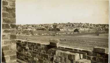
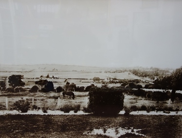
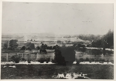
Photograph - East Kew, Looking Towards Balwyn, 1910-1930
... East Kew, Looking Towards Balwyn... of East Kew. ... areas of East Kew. Photograph East Kew, Looking Towards Balwyn ...Until post war subdivisions much of Balwyn and the eastern sections of Kew were rural farmlandVery large framed photographic enlargement of rural areas of East Kew. farmland (kew), kew farmland, farms, kew -
 Kew Historical Society Inc
Plan - Subdivision Plan, Jas R Mathers Son & McMillan, Macartney Estate, East Kew, c. 1925
... Macartney Estate, East Kew...subdivision plans - east kew...) and Evans Road in what was then designated as East Kew. Most... plans - east kew macartney estate Macartney Street Mount Street ...Pru Sanderson, in her groundbreaking ‘City of Kew Urban Conservation Study : Volume 2 - Development History’ (1988), summarised the periods of urban development and subdivisions of land in Kew. The periods that she identified included 1845-1880, 1880-1893, 1893-1921, 1921-1933, 1933-1943, and Post-War Development. These periods were selected as they represented periods of rapid growth or decline in urban development. An obvious starting point for Sanderson’s groupings involved population growth and the associated economic cycles. These cycles also highlighted urban expansion onto land that was predominantly rural, although in other cases it represented the decline and breakup of large estates. A number of the plans in the Kew Historical Society’s collection can also be found in other collections, such as those of the State Library of Victoria and the Boroondara Library Service. A number are however unique to the collection.Subdivision plans are historically important documents used as evidence of the growth of suburbs in Australia. They frequently provide information about when the land was sold on which a built structure was subsequently constructed as well as evidence relating to surveyors and real estate and financial agents. The numerous subdivision plans in the Kew Historical Society's collection represent working documents, ranging from the initial sketches made in planning a subdivision to printed plans on which auctioneers or agents listed the prices for which individual lots were sold. In a number of cases, the reverse of a subdivision plan in the collection includes a photograph of a house that was also for sale by the agent. These photographs provide significant heritage information relating house design and decoration, fencing and household gardens.The Macartney Estate subdivision advertised 21 lots for sale on either side of Macartney Street (now Macartney Avenue) and Evans Road in what was then designated as East Kew. Most of the houses shown on the south side of Macartney Street then, as now, have rear entrances on Mount Street, however a number of these blocks have since been further subdivided to allow for the building of new houses on the rear of a block. Brougham Place is marked on the plan but is now called Daniell Place."C"subdivision plans - east kew, macartney estate, macartney street, mount street, evans road, brougham place -
Kew Historical Society Inc
Archive (Series) - Presbyterian Church [East Kew]
... Presbyterian Church [East Kew]...East Kew Presbyterian Church – Kew (Vic.)...Kew Historical Society Inc 1 Civic Drive Kew melbourne East ...Various PartiesReference, Research, InformationArranged by Secondary Values (value of records to users)The Presbyterian Church in East Kew was formed in 1925, with a permanent building constructed by 1939 on Normandy Road. The church, established by Rev. Finlay McQueen was founded to aid those who lived far from the established church in Kew. It underwent extensions that opened in 1960. The file includes: Four copies of a history of the church on its 50th anniversary, and an order of service created to commemorate the opening of the extensions.east kew presbyterian church – kew (vic.), uniting church – kew (vic.), presbyterianism – kew (vic.), finlay mcqueen – kew (vic.)east kew presbyterian church – kew (vic.), uniting church – kew (vic.), presbyterianism – kew (vic.), finlay mcqueen – kew (vic.) -
 Kew Historical Society Inc
Photograph, Kew looking East to Deepdene, c.1905
... Kew looking East to Deepdene...Kew looking east towards Deepdene. Before 1909. The reverse... farming (kew) deepdene Kew looking east towards Deepdene. Before ...Kew looking east towards Deepdene. Before 1909. The reverse of the photograph includes an analysis of the photo and the places that can be seen within it (eg Deepdene Station, first Deepdene School, Burke Road etc)farming (kew), deepdene -
 Kew Historical Society Inc
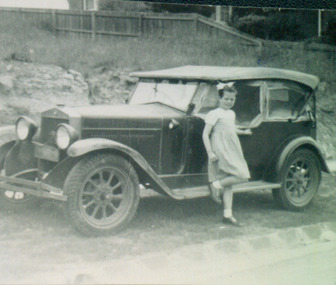
Photograph - Jane Coade and the Family Car, 1953
... 52 Frater Street -- Kew East(Vic.)..., outside 52 Frater Street, Kew East. The photographer was Mrs Doris... the house built for them. 52 Frater Street -- Kew East(Vic.) Coade ...52 Frater Street was the home of the Coade family who had the house built for them. Photograph of Jane Coade and 'Gert', the family car, outside 52 Frater Street, Kew East. The photographer was Mrs Doris Coade. Verso: "Jane & Gert / Nov. 1953"52 frater street -- kew east(vic.), coade family, jane coade -
Kew Historical Society Inc
Archive (Sub-series) - Subject File, Belford Farm (Kew East), 1958
... Belford Farm (Kew East)... into the Wade family. Belford Farm (Kew East) Archive Subject File ...Various partiesReference, Research, InformationKHS OrderSubject file containing genealogical research material on the Wades of Belford Farm, all photocopied. One item was prepared for a reunion of the descendants of Peter Robert & Mary Ann Mansergh (Blair) and James & Maria Mullins (Dartnell) who arrived in the Colony on the Sailing Ship ‘China’ on 1 May 1840. The item includes lists of passenger names and the names of their descendants. The other item is an inquiry from Elvania Balcombe, which includes her own research into the Wade family.wade family - kew (vic.), farming -- kew (vic)wade family - kew (vic.), farming -- kew (vic) -
 Kew Historical Society Inc
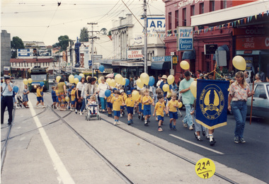
Photograph, Kew East Primary School, Kew Festival, 1992
... Kew East Primary School, Kew Festival... an album depicting participants in the 1992 Kew Festival Kew East ...The Kew Festival began in 1974. A feature of many festivals were the festival parades in which community groups participated. None of the photographs in the album are named so KHS welcomes viewers to identify participants and or locations.Photograph from an album depicting participants in the 1992 Kew Festivalkew festival - 1992 -
 Kew Historical Society Inc
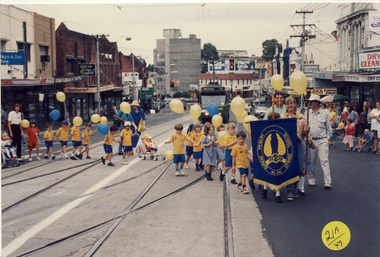
Photograph, Kew East Primary School, Kew Festival, 1992
... Kew East Primary School, Kew Festival... an album depicting participants in the 1992 Kew Festival Kew East ...The Kew Festival began in 1974. A feature of many festivals were the festival parades in which community groups participated. None of the photographs in the album are named so KHS welcomes viewers to identify participants and or locations.Photograph from an album depicting participants in the 1992 Kew Festivalkew festival - 1992