Showing 1252 items matching "land sale"
-
 Bendigo Historical Society Inc.
Administrative record - Land sales applications
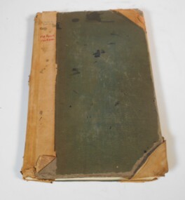
... the applications for allotments of land for sale. The headings in the book... Inc. History House 11 Mackenzie Street Bendigo goldfields Land ...Green cover book with brown leather spine. The book lists the applications for allotments of land for sale. The headings in the book are: number of application, date of registry, date of application, surname, Christian name and address, parish, allotment, section, area, local land board, Licence dated, licence issued, references and remarks. The book covers the years 1908-1960.On the cover in black ink "Castlemaine" and in red ink "138 front, 130 Rear" On the first page in pen: 138-129 front 130-121 back.land sales, castlemaine -
 Ringwood and District Historical Society
Flyer, Auction sale brochure advertising home sites with frontages to New Street, Ringwood, Victoria - 1961
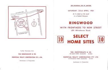
... Location map showing land for sale on New Street, Ringwood... Road Ringwood North melbourne Location map showing land ...Advertisement for Sub-divisional sale by auction on Saturday, 22nd April, 1961, with terms of sale of 10 home sites with frontages to New Street, Ringwood, Victoria.Location map showing land for sale on New Street, Ringwood, north of Palmerston Road. Auctioneers in conjunction - Yeo, Crosthwaite & Co., 108 Queen Street Melbourne (Telephone) MU 8605, and Perpetual Realty Corporation Pty. Ltd., 62 Swanston Street, Melbourne (Telephone) MF 3721. -
 Tatura Irrigation & Wartime Camps Museum
Book, Warwick Finlay, The Doctor, The Captain, The Poet and Others, 2004
... of the survey, naming of the town and sale of land at Murchison.... Anniversary of the survey, naming of the town and sale of land ...This book was printed to commemorate the 150th Anniversary of the survey, naming of the town and sale of land at Murchison.Black and white cover featuring the Goulburn River and portraits of Doctor McMillan, Captain John Murchison and Orion Horne over and early plan of Murchison Townshipmurchison -
 Ringwood and District Historical Society
Plan, Ringwood Station Estate, Subdivision, Ringwood, Victoria - circa 1925
... allotments for sale, with two typed pages attached showing land title... for sale, with two typed pages attached showing land title ...ID 5224 note: Further information relating to squares marked H, F, G, J, and K included in ID 5225 - Ringwood Shop and Dwelling Estate.Hand drawn plan of Ringwood Station Estate showing allotments for sale, with two typed pages attached showing land title information and sale prices.Drawn by Edyth Greenwood, phone 988 Central. Subdivision includes Station Street, Pitt Street, Bedford Road, Wantirna Road, James Street, William Street (later Kendall Street), Greenwood Avenue, Ellison Street, and Haig Street. Circles denote blocks for sale. Squares denote house properties for sale. Other features marked include location of businesses along Main Street (Maroondah Highway), cool store, railway station, shop and police station on Bedford Road, church on Station Street, site of schoolmaster's residence and State School, and location of proposed public baths. Ryner & Langford, Solicitors -
 Bendigo Historical Society Inc.
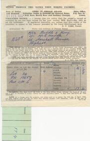
Document - H. A. & S. R. WILKINSON COLLECTION: CONTRACT OF SALE
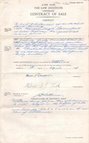
... Contract of sale of land (Cash) dated 1st April, 1955... ORGANIZATION Business h.a. & s.r wilkinson real estate Contract of sale ...Contract of sale of land (Cash) dated 1st April, 1955 between Mr. H. N. Davenport (vendor) and Mr. H. A. J. Smith (purchaser)organization, business, h.a. & s.r wilkinson real estate -
Port Melbourne Historical & Preservation Society
Document - Notice, Land auction, Williamstown Road to Plummer Street, Port Melbourne, R Holden Stone, Borough Surveyor Brighton and Port Melbourne, Mar 1887
... Large auction notice advertising sale of land Williamstown... advertising sale of land Williamstown Road to Plummer Street 19.3.1887 ...Large auction notice advertising sale of land Williamstown Road to Plummer Street 19.3.1887, with general (distorted) plan of Port Melborne and a larger plan of the allotmentstown planning, fishermans bend, land sales -
 Whitehorse Historical Society Inc.
Document, Best Estate, n.d
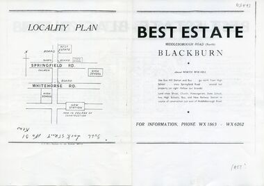
... Advertisement for sale of land at Best Estate, Blackburn... sale of land at Best Estate, Blackburn North. Part ...sale of land at Best Estate, Blackburn North. Part of the original land holdings of R. de Stoop and R. Best of British Fur Co.Advertisement for sale of land at Best Estate, Blackburn North. Part of the original land holdings of R. de Stoop and R. Best of British Fur Co.sale of land at Best Estate, Blackburn North. Part of the original land holdings of R. de Stoop and R. Best of British Fur Co.land subdivision, best estate, blackburn north, chapman street, middleborough road, joseph street, nestor grove, vivian street, de stoop, roger, best, richard, british fur company -
 City of Moorabbin Historical Society (Operating the Box Cottage Museum)
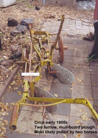
Tool - Farm Machinery, Horse-drawn Furrow Plough, Early 20th Century
... Special Survey' of 1841 and the Crown Land Sale in 1852. Land... and the Crown Land Sale in 1852. Land allotments were bought by pioneer ...Late 1800s-early 1900s A horse-drawn furrow plough is an example of the type of farm implement widely used by pioneer market gardeners in the Moorabbin Shire following 'Dendy's Special Survey' of 1841 and the Crown Land Sale in 1852. Land allotments were bought by pioneer settlers who established or rented allotments for market gardens in the area. They supplied produce to the markets in St Kilda and Melbourne. During the gold-rush of the 1850s the rapidly increasing population of Melbourne saw a huge demand and a rise in prices for all foodstuffs, including the vegetables and fruit grown in the Shire of Moorabbin. This heralded a time of prosperity for market gardeners, and an equally rapid expansion of the numbers of vegetable and produce growers in the area. The 'knock-on effect" resulted in an increased interest and development of the community in the Shire of Moorabbin.Following 'Dendy's Special Survey' of 1841 and the Crown Land Sale in 1852, land allotments were bought by pioneer settlers who established or rented allotments for market gardens in the area and they supplied produce to the markets in St Kilda and Melbourne. During the gold-rush of the 1850s the rapidly increasing population of Melbourne saw a huge demand and a rise in prices for all foodstuffs, including the vegetables and fruit grown in the Shire of Moorabbin. Circa late 1800's to early 1900s. A horse-drawn furrow plough was the most common type of agricultural implement used by the pioneers of the 1800s and continued on into the 1940s when motorised tractors came into use. This plough is an example of a two furrow, mullboard plough which would most likely have been pulled by two horses. The long handle was used to lower the silver plates, (mullboards), to the chosen depth of soil. Painted yellow. Although this Box Cottage museum plough is unbranded, the most widely used plough in the Shire of Moorabbin was made by Oliver. This plough appears to be identical to that brand. brighton, moorabbin, pioneers, fruit, bentleigh, vineyards, vegetables, plough, market gardens, plow -
 City of Kingston
Pamphlet - Colour, Ozone Hill Estate, Cheltenham, 1923
... : assumed land sale price is recorded on subdivisions 5-9, 9-10, 12.... This land sale pamphlet illustrates the subdivision of land within ...Sales plan for land in the suburb of Cheltenham, along both sides of Victori Avenue, off Weatherall Road.The developing urban area of Cheltenham within the City of Kingston. This land sale pamphlet illustrates the subdivision of land within the municipality and the changing demographic of the district as new houses are constructed.Colour pamphlet advertising for sale the Ozone Hill Estate, Cheltenham. Incorporates a map of the estate on either side of Victor Avenue, off Weatherall Road. Handwritten in blue ink on the subdivision map: 'Sold' is written on subdivisions 1-4, 8, 11, 13, 16-26, 28, 29, 33, 39-41 Handwritten in blue ink on the subdivision map: 'House being erected' is written on subdivisions 22 and 33. Handwrittten in grey pencil adjacent to subdivisions 21 and 22: Tennis / Courts / being / constructed / here Handwritten in grey pencil at bottom of page: Revised to 30/1/24 Handwritten in grey pencil on subdivision map: assumed land sale price is recorded on subdivisions 5-9, 9-10, 12, 14-15, 27, 30-32, 34-38. land sales, cheltenham, estate -
 City of Kingston
Pamphlet - Colour, Roy Dunn Pty. Ltd, Central Corner Estate Moorabbin and Highett, c. 1923
... Colour pamphlet advertising for private sale land... and Moorabbin within the City of Kingston. This land sale pamphlet ...Sales plan for land in the suburbs of Highett and Moorabbin, bordered by Point Nepean Road and Wickham Road East incorporating William StreetThe developing urban area of Highett and Moorabbin within the City of Kingston. This land sale pamphlet illustrates the subdivision of land within the municipality and the changing demographic of the district as new houses are constructed close to infrastructure.Colour pamphlet advertising for private sale land in the Central Corner Estate in Moorabbin and Highett. Incorporates a map of the estate bordered by Point Nepean Road and Wickham Road East, with subdivisions also available on both sides of William Street. Handwritten in blue pencil on subdivision plan: a tick is drawn on subdivisions 2-18 Handwritten in blue pencil on subdivision 6: a box with an x inside Handwritten in blue pencil on subdivisions 10 and 12: S Handwritten in black ink on front page: [indecipherable] / McKittricks Handwritten in grey pencil on rear page: McKilhick / Nepean Rd Handwritten in grey pencil on rear page upside down: 160000 / 15 8300 [crossed out] land sales, estate, highett, moorabbin -
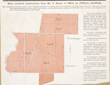 Bacchus Marsh & District Historical Society
Map, Bullengarook Estate Property Sale. 1911
... A single page paper map showing land allotments for sale... showing land allotments for sale from the Bullengarook Estate ...Bullengarook is a locality located 19 kilometers north of Bacchus Marsh. Pastoral leases for European colonists were granted to people for this area from around the 1840s.The Bullengarook Estate was part of these early pastoral holdings. By the 1900s the property had been owned by the Skene family for a number of years. In early 1911 the property then consisting of 300 acres and the homestead upon it was offered for sale in one lot. It appears however that the sale of the property did not go through in 1911. It was later leased by Thomas Skene to a Mr Coutts in 1915 and ultimately and at a later stage the property was sold by the Skene family.A single page paper map showing land allotments for sale from the Bullengarook Estate. The map is pasted into a bound volume containing 76 maps or plans in total. High resolution digital image stored on BMDHS computer network. land sales bacchus marsh, bullengarook land sales, bullengarook estate, bullengarook vic history -
 Whitehorse Historical Society Inc.
Document - Extract of Land Conveyance, Patrick Riley, 9/5/1870
... /5/1870 for sale of land in the Parish of Nunawading. Sold... Mitcham melbourne land sales; riley patrick james coyne Photocopy ...Photocopy of extract of Memorial Book of conveyance dated 9/5/1870 for sale of land in the Parish of Nunawading. Sold by James Coyne Riley to Patrick Riley. 3 pages.land sales;, riley, patrick, james coyne -
Ringwood and District Historical Society
Book - Eureka Plan, Farmer, Mr, Eureka Plan, c. 1930
... Created to assist in promotion and sale of land near... and sale of land near Ringwood Railway station, following ...Created to assist in promotion and sale of land near Ringwood Railway station, following completion of the electric rail to Ringwood..Book containing details of seven delightful and valuable Ringwood properties - Bestpart, Paradur, Hill Top, Greenwood, Creek, Station and School estates. The book has 16 photos and 20 plans and 20 pages. There are multiple copies of pages 20x2; 19x2; 18x4; 17x4 and 20x2. +Additional Keywords: Farmer, Mr -
 City of Moorabbin Historical Society (Operating the Box Cottage Museum)
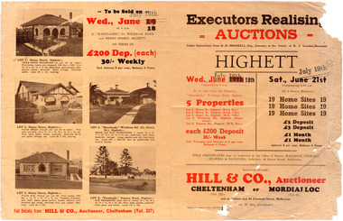
Flyer - Executors Realising Auction for land in Highett, 1941
... The Great Depression of Australia halted the sale of land...Sale of land in Highett - Hill & Co (A. W. Hill, Auctioneer... Depression of Australia halted the sale of land in most circumstances ...The Great Depression of Australia halted the sale of land in most circumstances - this sale was just after the end of the depression years of 1930 to 1939.Example of the progress of the Municipality of MoorabbinAdvertising flyer for auction of real estate sales - plan of building blocks for saleSale of land in Highett - Hill & Co (A. W. Hill, Auctioneer) - brochure has pictures of the houses on the properties being offered for saleviola crescent, wickham road, henry street, real estate, highett, moorabbin, auctions, benjamin lowden -
 Phillip Island and District Historical Society Inc.
Documents, c1970
... Documents relating to the sale of land Lot 34, P/s 13650... to the sale of land Lot 34, P/s 13650. Part C/A 6 in Ventnor. Includes ...Documentation donated by Rob & Kathy Huddle, Glen Isla Motel, Church Street, Cowes Phillip IslandDocuments relating to the sale of land Lot 34, P/s 13650. Part C/A 6 in Ventnor. Includes Transfer of Land, Receipts for purchase, Rate Notice and Notice to Destroy Noxious Weeds.rose emma huddle, hilda joy king, rob & kathy huddle, ventnor land, glen isla, council rates, ventnor estate, noxious weeds -
Port Melbourne Historical & Preservation Society
Document - Vendors Statement for the sale of Lot 35 Beacon Cove, Port Melbourne, 1996
... pursuant to Section 32 of the Sale of Land Act 1962 for Lot 35... to the Purchaser of Real Estate pursuant to Section 32 of the Sale of Land ...Lot 35 is now titled 18 Park Square, Beacon Cove, Port MelbourneFolder with pale green cover and black spiral binding. Folder contains Vendors Statement to the Purchaser of Real Estate pursuant to Section 32 of the Sale of Land Act 1962 for Lot 35 Beacon Cove.built environment - domestic, department of planning and development, park square, beacon cove, mirvac -
 Melbourne Tram Museum
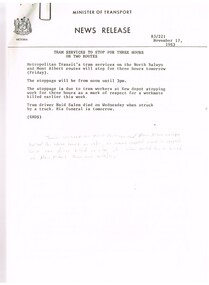
Document - Press Release, Minister of Transport, "Press Statement", Nov. 1987
... - issued 11/11/1983 - A class trams. 6. "New Rail land sale... - issued 11/11/1983 - A class trams. 6. "New Rail land sale ...Set of 11 New Releases or Press Releases with Minister of Transport letterhead. Photocopied onto A4 paper. 1. Tram services to stop for three hours on North Balwyn and Mont Albert - 18/11/1983 as a mark of respect to Naid Salem when struck by a truck at the Mont Albert terminus on 16/11. (hand written not on the sheet). 2."The Met" fare system starts today - Steve Crabb - 13/11/1983. 3. "New tram a design to meet the needs of the year 2000" - Minister visits Comeng Plant - A class trams 4. "Bonus travelcard on sale" - 10/11/1983 5. "A tram for the year 2000" - follow up - issued 11/11/1983 - A class trams. 6. "New Rail land sale on tomorrow - sale of surplus land in Doncaster - Templestowe Area" - following a decision to consider light rail rather than heavy rail. 7 "Homes now getter Transport Information Booklet" - explaining the Neighbourhood system. 8. "One Million booklets to be home delivered to explain The Met transport system" - 6/11/1983. 9. "Public Transport more cost efficient than the car" - 7/11/1983 - looks at The Met tickets pricing. 10. "Boards name for the New Transport Authorities" - 28/6/1983 - lists the names for the various authorities.Item 4 has a handwritten note in ink "NB now half a "Grand Union" at Sydney Road & Moreland Rd"trams, tramways, news broadcasts, minister for transport, mont albert, tickets, a class, doncaster, neighbourhood tickets -
![Advertising Leaflet, John McEwen and Co, Heidelberg Park Estate [Lower Plenty], 1913c](/media/collectors/4f729f5697f83e03086015b8/items/5dcfb52321ea671434e9ca4c/item-media/5dcfb56321ea671434ea0352/item-fit-380x285.jpg) Greensborough Historical Society
Greensborough Historical SocietyAdvertising Leaflet, John McEwen and Co, Heidelberg Park Estate [Lower Plenty], 1913c
... Copy of auction leaflet for the sale of land fronting... for the sale of land fronting the Plenty River. Known as Heidelberg ...Copy of auction leaflet for the sale of land fronting the Plenty River. Known as Heidelberg Park, this land is in what is now Lower Plenty. Sale circa 1913Digital copy of auction leaflet, 1 page.heidelberg park, lower plenty, land sales -
Glen Eira Historical Society
Document - LAND SUBDIVISIONS 1880-1938
... and cards. 1/Advertising announcement for auction sale of land (15... sale of land (15 lots) at Glenhuntly Tram Terminus, to be held ...This file contains various subdivisions’ advertising flyers and cards. 1/Advertising announcement for auction sale of land (15 lots) at Glenhuntly Tram Terminus, to be held on 29/03/1924. Verso is map of the area (21.5cm x 29cm) 2/Advertising announcement for Trustees’ Auction sale of corner shop sites at Caulfield South near Glenhuntly Road and Hawthorn Roads, 15/11/1927 (21cm x 31cm) 3/Advertising pamphlet (A3) for auction of Cantala Estate, East St. Kilda (32 allotments), between Dandenong, Waiora, and Alma Roads, 21/05/1938 (15.5cm x 28.5cm) 4/Seven advertising postcards relating to auctions of land in Caulfield and Elsternwick. Only one (10 December 1881) with a year on it. (Each 13.5cm x 9cm) 5/Four more advertising postcards relating to auctions of land in Caulfield. One is dated 31/11/1880(?); another 09/02/1905. A third has no date. A fourth postcard is a map of allotments between Orrong, Kooyong, Seymour and Alison Roads, Caulfield, no date (each 13.5cm x 9cm) 6/Large advertising poster (41cm x 52.5cm) for ‘Carnegie Land Sale’ auction of the Egan Estate (near Carnegie Railway Station) on 12 April, no year given, but appears to be circa1900 7/‘Riddell Estate – Plan of Subdivision – Parish of Prahran’ mounted map, no date, probably c. 1900 (16cm x 21cm)auctions, house auctions, land subdivision, land development, subdivisions, caulfield, land subdivisions, east st. kilda, glenhuntly, carnegie, map, ‘new glenhuntly tram terminus estate’, ‘cantala estate’, ‘strathnaver estate’, ‘range estate’, ‘egan estate’, ‘riddell estate’ -
 Kilmore Historical Society
Photograph, Oriental Bank Corporation, 1866
... . A sign on post at back of building reads: Land for Sale Apply.... A sign on post at back of building reads: Land for Sale Apply ...This photograph was most likely taken for the 1866 Intercolonial Exhibition in Melbourne.25cm x 20cm black and white reproduction of a photograph of the Oriental Bank Corporation, 7 Sydney Street Kilmore, from the State Library of Victoria. Double storey building with decorative parapet along roofline, wrought iron balconets at upper storey windows, decorative hood molds above windows, name of bank in stone under ground floor cornice, a man standing on path in front of bank. Woman standing at back of building in shadow. A sign on post at back of building reads: Land for Sale Apply to W. Grace Solicitor Kilmore.Printed on back: REPRODUCTION RIGHTS RESERVED Copied by State Library of Victoria Tenders called for erection of this building in March 1864.banks, 19th century -
 Eltham District Historical Society Inc
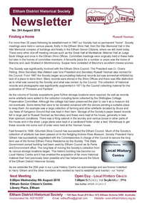
Newsletter, Eltham District Historical Society, Newsletter, No. 241 August 2018
... – Childhood Reminiscences – Part 5 by Ann Constable • Land for Sale... – Childhood Reminiscences – Part 5 by Ann Constable • Land for Sale ...Contents: • Finding a Home by Russell Yeoman • Our Next Meeting – Wednesday 8th August 2018 • Open Day at our Local History Centre – Saturday 1st September 2018 • Eltham 1950s – Childhood Reminiscences – Part 5 by Ann Constable • Land for Sale at Little Eltham by Russell Yeoman • The County of Evelyn by Russell Yeoman • An ‘enlightening’ tale by Jim Connor • The Andrew Ross Museum by Mick Woiwod • Kangaroo Ground – Centre of the Shire by Mick Woiwod • On the Thirsty Road to the Diggings by Mick Woiwod • Contacts for the Eltham District Historical Society The Shire of Eltham Historical Society was formed in October 1967. The first newsletter of the Society was issued May 1978 and has been published continuously ever since on a bi-monthly basis. With the cessation of the Shire of Eltham in late 1994, the Society's name was revised to Eltham District Historical Society and this name first appeared with issue No. 103, July 1995. The collection of the Society's newsletters provides a valuable resource on the history of the Society's activities, office bearers and committee members, guest speakers and subjects of historical interest pertinent to the former Shire of Eltham and the Eltham District.A4 newsletter distributed to membersnewsletter, eltham district historical society -
 Warrnambool and District Historical Society Inc.
Documents, Swintons Paper att 18/53 Merri St. Contract. Map. Notes, 1959
... These documents relate to the sale of land in Merri Street...The items here relate to the sale of land by Swintons Pty... These documents relate to the sale of land in Merri Street Warrnambool ...These documents relate to the sale of land in Merri Street Warrnambool in 1959 by Swintons Pty Ltd of Warrnambool. The buyer of the land was George O’Grady, a Warrnambool baker. The land sold for £4000 and there was a shed on the land (called the ‘Office’) which George O’Grady indicated he wished to be included in the sale. William and Ann Swinton migrated to Australia in 1854 and for a decade William Swinton worked as a builder and carpenter in the Warrnambool area, erecting many buildings, including the Wangoom Presbyterian Church. In 1865 he opened a store in Timor Street Warrnambool, selling groceries, hardware, china and glassware. By 1888 the business was known as William Swinton and Sons. Branch stores were opened in Wangoom, Cudgee, Nullawarre, South Warrnambool and West Warrnambool. After William Swinton died his son Robert became the first managing director of Swintons Pty Ltd. In 1934 the business split with George Swinton and Sons selling clothing, furnishings and glassware and Swintons Pty Ltd selling seeds, produce and hardware. Today the Swinton family still operates a furniture and bedding shop in Timor St Warrnambool.These items are of some interest as being connected to the Warrnambool business of Swintons Pty Ltd. They will be of interest to researchers. The current Swinton business in Timor Street is the oldest family business in Warrnambool and, with the name Swinton associated with businesses in Timor Street Warrnambool for 152 years it is amongst the oldest family businesses in Australia.The items here relate to the sale of land by Swintons Pty Ltd., Warrnambool. .1 These are three pages of white paper with typed material, a lawyer’s signature in blue ink, one green stamp and a sketch of the land location. .2 This is a sheet of thick paper containing a plan of the land sold. The paper has printed material and a sketch of the land with part of it coloured in pink. .3 This is a small piece of paper torn at the bottom right edge. It has handwritten material (a letter) in blue ink..2 ‘Plan of Survey of Part of Crown Allotment 18 Section 3 Township of .2 ‘Plan of Survey of Part of Crown Allotment 18 Section 3 Township of Warrnambool Parish of Wangoom County of Villiers’ .3 ‘Tuesday Dear Mr Swinton I am writing to say that I would like to have the ‘Office’ Thanking You George O’Grady’swinton family,, warrnambool -
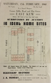 Kew Historical Society Inc
Plan - Subdivision Plan, Subdivision by Auction: 16 Ideal Home Sites, East Kew, 1940, 1940
... An advertisement for the sale of a subdivision by Auction... Sites, East Kew, 1940. This significant sale of land between ...An advertisement for the sale of a subdivision by Auction: of 16 Ideal Home Sites, East Kew, 1940. This significant sale of land between the Kew Golf Course and Willsmere Park led to the streets having a high degree of architectural uniformity.The subdivision in the second year of the war indicates that land sales for homes and speculation continued from the 1930s into the period of the Second World War. There is no indication on the plan that a war is occurring.Single page subdivision plan advertising the sale by Auction of 16 Ideal Home Sites, in East Kew, on 17 February 1940. Streets named in the plan include: Kilby Road, Belford Road, Elm Grove, Willow Grove. Willsmere Park is indicated but not named. The auction was conducted by Beauchamp Brothers. A number of lots are coloured pink on the plan indicating those lots for sale and/or those already sold.subdivision plans - kew east (vic) -
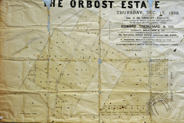 Orbost & District Historical Society
poster, 1898
... was owned by his son, Rupert who offered the land for sale at 4... was owned by his son, Rupert who offered the land for sale at 4 ...This poster was made for the sale of the 1,440 acres of Orbost Station after the death of Sir William Clarke. It was sold by Edward Trenchard & Co. which was the oldest Stock and Station agent in Victoria assisted by Desailly, Macarthur & Co were livestock experts. Sir William Clarke had taken over the Orbost run from the McLeods in 1870. When Sir William died the property was owned by his son, Rupert who offered the land for sale at 4 pounds per acre. No sale resulted and the property was leased for a few years until in 1898 it was subdivided and sold to many of Orbost's first families. (info. from In Times Gone By- Deborah Hall)This is an important reminder of the very early history of the settlement of Orbost.A rectangular paper poster for the sale of the Orbost Estate on Forest Road, Orbost. It is dated "Thursday Dec 1898" and was made for the sale of the 1,440 acres of Orbost Station after the death of Sir William Clarke. The poster gives written details of the sale and a plan of the property.orbost-station clarke-sir-william orbost-estate -
![Advertising Leaflet, Grace Park Electric Station Estate, Watsonia [3], 21/06/1924](/media/collectors/4f729f5697f83e03086015b8/items/5dcfb9c821ea671434edd447/item-media/5dcfb9e821ea671434ededfc/item-fit-380x285.jpg) Greensborough Historical Society
Greensborough Historical SocietyAdvertising Leaflet, Grace Park Electric Station Estate, Watsonia [3], 21/06/1924
... Digital copy of auction leaflet for sale of land known... for sale of land known as Grace Park Electric Station Estate ...Digital copy of auction leaflet for sale of land known as Grace Park Electric Station Estate, Saturday 21/06/1924. Auctioneer Knight & Harwood in conjunction with C. Jessop. This leaflet shows a photograph of the 'Grace Park Railway Station' nearing completion.Digital copy of auction leaflet 1 page. Black and red text on white paper.watsonia, grace park -
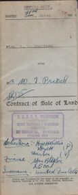 Bendigo Historical Society Inc.
Document - H.A. & S.R. WILKINSON COLLECTION: CONDITION OF SALE
... Contract of sale of land dated 24th March, 1954 between... ORGANIZATION Business h.a. & s.r wilkinson real estate Contract of sale ...Contract of sale of land dated 24th March, 1954 between miss A.M. Houlihan (seller) and Mr. W.T. Priest (buyer) for land situate 12 Reserve Street Eaglehawk described in Right to Occupy Residence Area No. 5362, together with weatherboard dwelling and all sundry. Price 1,000 pounds.organization, business, h.a. & s.r wilkinson real estate -
Federation University Historical Collection
Poster - Signs, Window signs by Keith Rash
... Feb. 1853 at the Government Land Sale, Mr C.N. Thorne... at the Government Land Sale, Mr C.N. Thorne purchased this area. In 1893, R ...It is thought the signs were used for Ballarat's Gold Centenary in 1851.Seven window signs by Keith Rash painted onto wallpaper. The signs were designed to sit in shop windows to tell the history of the shop of company. .1) In 1862 Eurgene Bourdet conducted the "Imperial Dining Rooms" here. Board 20/- Board & Lodging 25/- week .2) On 16th Feb. 1853 at the Government Land Sale, Mr C.N. Thorne purchased this area. In 1893, R. Ludbrook used this property as Auction Rooms. .3) McArtney & aldred first occupied these premises in 1856. There were coachbuilders. .4) From the Single Storeyed wooden building once her J.P. Clarke operated as a carrier until 1865. Welsh & Surplice took over as Estate Agents until 1870. .5) Dr James Stewart built this property H.G. Harrison, 1957. J.C. Proctor 1862, John Stokes 1865, were chemists here. In 1856 The Savings Bank commenced here. W.H. Pooley, actuary .6) Wm Moss, tinsmith, occupied this site in 1865. Thos. Freeman,a uctioneer in 1882. .7) Doig & Cant. Gasfitters & Plumbers came here from Main Road in 1866. After 38 years A. Cant removed 2 doors further north .8) In 1871, This part was the shop of Wm Moss, tinsmith & plumberballarat, doig, cant, plumber, william moss, tinsmith, thomas freeman, james stewart, h.g. harrison, j.c. proctor, john stokes, savings bank, w.h. pooley, j.p. clarke, welsh, surplice, mcartney, aldred, coachbuilders, c.n. thorne, r. ludbrook, eugene bourdet -
![Advertising Leaflet, Grace Park Electric Station Estate, Watsonia [1], 21/06/1924](/media/collectors/4f729f5697f83e03086015b8/items/5dcfb6fc21ea671434eb6c09/item-media/5dcfb72a21ea671434eb91fa/item-fit-380x285.jpg) Greensborough Historical Society
Greensborough Historical SocietyAdvertising Leaflet, Grace Park Electric Station Estate, Watsonia [1], 21/06/1924
... Digital copy of auction leaflet for sale of land known... for sale of land known as Grace Park Electric Station Estate ...Digital copy of auction leaflet for sale of land known as Grace Park Electric Station Estate, Saturday 21/06/1924. Auctioneer Knight & Harwood in conjunction with C. Jessop. This leaflet shows a home on the estate and a photograph of the proposed site of the 'Grace Park Railway Station'.Digital copy of auction leaflet 1 page. Black and red text on white paper.watsonia, grace park -
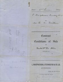 Bendigo Historical Society Inc.
Document - CONNELLY, TATCHELL, DUNLOP COLLECTION: CONTRACT
... Printed Contract and Conditions of Sale of Land, & c... Young Printed Contract and Conditions of Sale of Land, & c ...Printed Contract and Conditions of Sale of Land, & c., dated 2 June 1898. Contract is for the sale of a property sold to Mr. Bartholomew A Walllace of Macorna. Contract sets out the payment schedule. Agents were L. Macpherson, Sternberg & Co. Ltd. Orange Victoria One Penny Duty Stamp attached.business, legal, connelly & tatchell, connelly & tatchell collection - contract, l macpherson sternberg & co ltd, bartholomew a wallace, j b young -
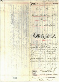 Bendigo Historical Society Inc.
Document - CONVEYANCE DOCUMENTS FOR R. H. S. ABBOTT
... Conveyance document for sale of land from Dr. James Boyd... Conveyance document for sale of land from Dr. James Boyd to Richard ...Conveyance document for sale of land from Dr. James Boyd to Richard Hartley Smith Abbott. Dated 21.6.1900. Sale of three blocks of land for the sum of six hundred and fifty pounds. a. Allotment 6 of Section 8C b. Allotment 14 of Section 8C c. Allotment 13 of Section 8C