Showing 44518 items
matching land-conservation-east-gippsland
-
 Orbost & District Historical Society
black and white photograph, late 19th century - early 20th century
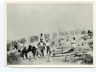
This photograph shows land clearing at Bendoc. From 1845 the Bendoc area was part of pastoral leases. In the 1850s alluvial gold was discovered in the Bendoc River. This was quickly exhausted, and a number of mines began successful reef operations. At the head of the river, the settlement of Clarkville clustered round several other mines. Many miners, including numbers of Chinese, sluiced the rivers. The population of the area was as high as 500 during this period. The township was surveyed in 1869 and the hotel built in 1870. This building was burnt down in the early 1900s and rebuilt. A school was also begun at this time. In the 1870s there was a decline in gold mining. Some miners selected land, which in many cases is still held by descendants. Dairying was common in the early days, supplying a butter factory at the New South Wales border, and a milk factory at Orbost in more recent times. Wheat was grown for the settlers' own use and ground at Bombala. Now beef cattle grazing is the main occupation. (info. from Victorian Places)This is a pictorial history associated with the early settlement of Bendoc in East Gippsland.A badly distorted black / white photograph of a horse drawn wagon, three men and two women clearing land.on back - "Clearing land at Bendoc"bendoc-land-clearing bendoc-early-settlement -
 Orbost & District Historical Society
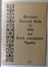
book, E-Gee Printers, Gippsland Electoral Rolls for 1856 and Stock Assessment Payable, 1985
The Electoral Act 1856 was passed through Parliament o March 13, 1856. Victoria was the first Australian colony, and the first legislature anywhere in the world, to adopt the practice of the secret ballot. Victoria's constitution prescribed that the Parliament was to be bicameral, consisting of an upper house, the Legislative Council and a lower house, Legislative Assembly. Men were entitled to vote according to the qualifications described in this book - the right to vote in each house was dependent on status - educational qualifications, income and for either literacy. Two names are registered for the Orbost district: James Dickson and J.C. McLeod.This item is a useful research tool.A 16 pp paper back book which has a clear plastic cover. The covers are beige coloured with the title "Gippsland Electoral Rolls for 1856 and Stock Assessment Payable" in blak print. On the left hand side is a vertical pattern in black print. The book contains an alphabetical list of persons claiming or supposed to be entitled to Vote in the Election of a Member for the District. It lists the needed qualifications of electors followed by the Voters Roll for Legislative Assembly, 1856 and the Voters Roll for Legislative Council, 1856 . It then lists the Stock Assessments, 1856.voting-registers-victoria -
 University of Melbourne, Burnley Campus Archives
Administrative record, Andrew Smith et al, University of Melbourne Institute of Land and Food Resources Burnley Campus Gardens Staffing 2003-04, 2003-2005
mainrenance, garden maintenance, property & buildings, staff descriptions, transition -
Koorie Heritage Trust
Book, Beauglehole, A. C, The distribution and conservation of vascular plants in the Gippsland Lakes hinterland area, Victoria, 1985
Col. map on 1 folded sheet in pocket. Bibliography: p. 9-10.botany -- victoria -- gippsland. -
Koorie Heritage Trust
Book, Beauglehole, A. C, The Distribtion and Conservation of Vascular Plants in the South Gippsland area, Victoria, 1984
i-iii; 90 P.; fold-out map on end-cover; tables; maps; ill.; appendices.21 cm.south gippsland, vic.-fauna and flora. -
University of Melbourne, Burnley Campus Archives
Magazine - Journal articles, Melbourne School of Land and Environment et al, Land & Environment, 2013
green roofs, sugar table -
Lakes Entrance Regional Historical Society (operating as Lakes Entrance History Centre & Museum)
Photograph, Judy Davies, 1990 c
Also a colour photograph of waterway adjacent to Cossticks Weir East Gip[psland 04650.1 15 x 10 cmColour photograph of water spilling over the rock wall at Cossticks Weir East Gippsland Victoriabridges, waterways -
 Kew Historical Society Inc
Administrative record, East Kew Women's Club, Attendance Register, 1971-1973
The East Kew Women’s Club was formed on 20 July 1945 as an experiment amongst local women, who felt that there was a need for some organised group to give full scope to their various interests and hobbies. In the beginning, they met at the house of their founder, Mrs Eric Thake, 48 Harp Road, East Kew, but the growth and interest was so rapid that it was soon necessary to find a larger meeting place, so the group moved to the Harrier’s Pavilion in Victoria Park, Kew. At the fifth meeting of the group, a committee was formed, and a constitution adopted on 4 December 1945.The Club was aimed to be non-political, non-sectarian and open to women from any locality. The Club’s motto was “To Help others, Improve Ourselves, and Foster the Community Spirit”. The first twenty years of the Club was recorded in a small, nine-page publication “East Kew Women’s Club : Twenty Years 20-7-1945 - 30-7-1965”. Following the closure of the Club in 1973, after twenty-eight years, its records were deposited with the Kew Historical Society and are thus available for research into the history of women’s groups in the post war period in Australia. The Society holds the Club’s Minute Books of Meetings (1953-73), Attendance Registers (1959-73), Visitors Book, and sundry items of print ephemera published by the Club.Document: Attendance Register, East Kew Women’s Club, 1971-73east kew women's club, community groups -- kew (vic.) -
 Orbost & District Historical Society
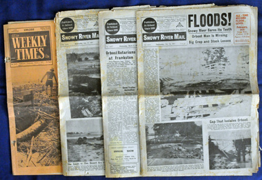
newspapers, February, March 1971
The 1971 flood was the the worst flood on record. At Jarrahmond it was at least 11 metres and up to one and a half kilometres wide on the flats causing enormous damage to the flood plain. Records say that "The brown floodwater stain in Bass Strait could be seen from passing airliners." Considerable damage was done to railway infrastructure, roads and farms. More information from the APRIL, 2008 newsletter by John Phillips. (see orbosthistory.com.au) These newspapers are contemporary records of a significant local event.Four newspapers relating to the floods in 1971. They contain news articles and photographs of the floods in Orbost in early 1971. 2556.1 is the Weekly Times dated 3.3.1971 and has an orange cover. 2556.2 is a Snowy River Mail dated 17.2.1971. 2556.3 is a Snowy River Mail dated 10.2.1971. 2556.4 is a Snowy River Mail dated 3.3.1971.floods-orbost-1971 snowy-river-mail weekly-times newspapers -
Lakes Entrance Regional Historical Society (operating as Lakes Entrance History Centre & Museum)
Book, East Gippsland Historical Society, Some Historic Buildings in Bairnsdale, 1979
A short history of Bairnsdale Victoria with descriptions of some of the more notable older buildings.township -
Lakes Entrance Regional Historical Society (operating as Lakes Entrance History Centre & Museum)
Book, East Gippsland Regional Planning Committee, Holding on to our History, 1980
Details of historical sites with comments about the money raising activities. History of construction..historic sites, charities, architecture -
Lakes Entrance Regional Historical Society (operating as Lakes Entrance History Centre & Museum)
Photograph, East Gippsland Newspaper, 10 x 15 cm
Mr Robinsion started for the LE Fisherman's Ciop in 1962 took over the next year for eleven years. He passed it to John Duffy who served the fleet for thirteen years.Colour photograph of LERHS member Marion Holding with Shipwright Leigh Robinson holding twelve years shipwright records for Lakes Entrance from 1962 to 1974 taken at Maritime Museum Paynesville Victoriacelebrations, historical society -
Lakes Entrance Regional Historical Society (operating as Lakes Entrance History Centre & Museum)
Photograph, East Gippsland Newspaper, 1/10/2014 12:00:00 AM
Colour photograph of LERHS members Robyn Purdy and Marie Fish at Garden Club exhibition at Mechanics Hall Lakes Entrancehistorical society, historic sites -
Lakes Entrance Regional Historical Society (operating as Lakes Entrance History Centre & Museum)
Photograph, East Gippsland Newspaper, 1/11/1990 12:00:00 AM
Also a second black and white photograph of vessel 04821.1 7 x 11 cmBlack and white photograph showing the Esso work boat Lady Penelope towing disabled yacht Moga in Bass Straitboats and boating, oil and gas industry -
Lakes Entrance Regional Historical Society (operating as Lakes Entrance History Centre & Museum)
Photograph, East Gippsland Newspaper, 1/10/2014 12:00:00 AM
Colour photograph taken of Rev Barb Logan, Ian Buchnall, Phillip Carr designer and Alan Bolding builder, crowd in background at dedication of new bell tower at St Nicholas Anglican Church Lakes Entrance Victoriaclubs, religion -
Lakes Entrance Regional Historical Society (operating as Lakes Entrance History Centre & Museum)
Photograph, East Gippsland Newspaper, 1/10/2005 12:00:00 AM
Colour photograph of Bridge players Kay Bignell Vic Burton and John Matthews at a Charity Bridge game Lakes Entrance Victoriacelebrations, clubs -
Lakes Entrance Regional Historical Society (operating as Lakes Entrance History Centre & Museum)
Photograph, East Gippsland Newspaper, 1/10/2005 12:00:00 AM
Colour photograph of Bridge players Mary Duncan Sally Bales Mary Brown and Dick Bales at Charity Bridge game Lakes Entrance Victoriaclubs -
 Lakes Entrance Regional Historical Society (operating as Lakes Entrance History Centre & Museum)
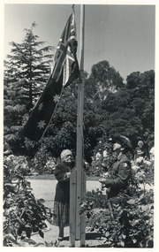
Photograph, East Gippsland Newspapers, 1989c
Black and white photograph of Mrs Vi Symmons nee Coate raising the flag during the Australia Day ceremony with a member of the 13th Light Horse at the flagpole in the rose garden at Nyerimilang Park Kalimna West Victoriagenealogy -
 Lakes Entrance Regional Historical Society (operating as Lakes Entrance History Centre & Museum)
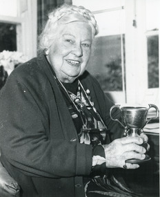
Photograph, East Gippsland Newspaper, 1989
Black and white photograph of Mrs Vi Symmons nee Coate taken during an interview with local newspaper reporter prior to her 88th birthday, Lakes Entrance Victoriacelebrations, genealogy -
 Federation University Historical Collection
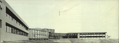
Photograph, Gippsland Institute of Advanced Education Ampitheatre, c1976
The Gippsland Institute of Advanced Education was established by an Order-in-Council in September 1968. The Council of the Institute included members of the Gippsland community who are prominent in local government, industry, commerce, education and the professions, the Director of the Institute, and representatives of the academic staff, students, and graduates. On its establishment, the institute assumed responsibility for the diploma courses previously offered by the Yallourn Technical College which had commenced diploma teaching in 1929. Initially, all the Institute's teaching was conducted in the diploma building of the Yallourn Technical College. In 1972 the Institute transferred part of its operations to the first of its permanent buildings on a large campus in rural surrounds near the township of Churchill, ten kilometres south of MOrwell and one hundred and sixty kilometres east of Melbourne. The Gippsland Institute of Advanced Education was opened on 20 November 1976 by the Honourable Lindsay Thompson, Deputy Premier of Victoria and Minister of Education; and Senator J.L. Carrick, Minister for Education in the Commonwealth Government. The Gippsland Institute of Advanced Education ampitheatregippsland institute of advanced education, gippsland campus collection, churchill, ampitheatre, buildings -
Phillip Island and District Historical Society Inc.
Book, GRAYDEN, Christine, island worth conserving : a history of the Phillip Island Conservation Society 1968-2008, 2008
Signed by the author.phillip island conservation society, history, environmentalists, victoria, phillip island, societies, environmental protection -
Federation University Historical Collection
Booklet - Report, Sturt Street Gardens, Ballarat, Victoria, Conservation and Landscape Management Plan, July 2007, 07/2007
The Sturt Street Gardens had its origins in the 1851 survey of Ballarat West by W.S. Urquhart. A generous reserve was allocated for the main streets of Ballarat, of which Sturt Street was the first. In the 1860s Sturt Street was planted with blue gums, with dual carriageway and central median Strip. Bandstands were soon erected.70 page report on the Ballarat Sturt Street gardens. The report includes an historical overview, Physical Analysis, Statement of Cultural Significance, and Consideration and Landscape Policies.queen alexandra bandstand, titanic memorial bandstand, sturt street, sturt street gardens, blue gum, statues, eight hour day memorial, boer war memorial, peter lalor statue, bluestone, bluestone guttering, william dunstan vc, time capsule, conservation management plan, landscape management plan -
 Federation University Historical Collection
Book, Ballarat Conservation Guidelines, 1981, 1981
The Guidelines were commissioned by the City of Ballarat , Historical Buildings Preservation Council and the Australian Heritage Commission.Cream soft coloured book of 60 pages. Contents include - Contributary Commercial Buildings, New COmmercial Buildings, Contributary residential Buildings, New Residential Development, Public and In stitutiona Buildings, Railways, Cemeteries, Botanic Gardens, Lake Wendouree, Public Open Spaces, Street Works, Fences and Landscaping, Advertising Guidelines, Lydiard/Camp Street Precinct Case Studyballarat, conservation guidelines, lydiard/camp street precinct case study, railway, botanic gardens, guttes, footpaths, signs, signage, fences, robin nuttall, gerald jenzen, ray tonkin, conservation study, architectural styles, verandahs, shopfronts, cast iron, wndy jacobs, miles lewis, gary vines, heritage planning, heritage guidelines -
Koorie Heritage Trust
Book, Brown, Rik, The upper Yarra River corridor : sites of conservation significance, 1993
179 p.; maps; appendices; 30 cm.environmental protection -- victoria -- yarra river region. floodplain management -- victoria -- yarra river region. ecology -- victoria -- yarra river region. biodiversity conservation -- victoria -- yarra river region. yarra river region (vic.) -
Ballarat Heritage Services
Document - Report, McDougall and Vines Conservation and Heritage Consultants, Sturt Street Gardens, Ballarat, Victoria Conservation and Landscape Management Plan, 2007, 07/2007
Ballarat's Sturt Street has its origins in W.S. Urquhart's survey of 1851. A generous reserve was allocated for the main streets of Ballarat, of which Sturt Street was the first. In the 1860s Sturt Street was planted with blue gums, with a dual carriageway and central median strip installed. Bandstands ere soone erected, including the Queen Alexandra Bandstand (1908) and the Titanic Memoria Bandsatnd (1915).PDF of a report on the Sturt Street Gardens, Ballarat.sturt street ballarat, conservation management plan, sturt street gardens, landscape management plan, statue, gardens, bandstands, infrastructure, city of ballarat report -
 Whitehorse Historical Society Inc.
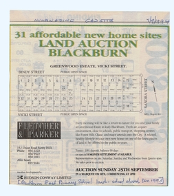
Article, Land Auction, Blackburn, 7/09/1994 12:00:00 AM
old Blackburn Advertisement in the Nunawading Gazette 7 September 1994Advertisement in the Nunawading Gazette 7 September 1994 for auction of the old Blackburn East Primary School (closed December 1993) land. Auction 25 September 1994. Greenwood Estate, Nicoli Street.old Blackburn Advertisement in the Nunawading Gazette 7 September 1994 land subdivision, bindy street, blackburn south, vicki street, sandra street, blackburn east primary school, no. 4800 -
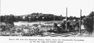 Ringwood and District Historical Society
Photograph, Image used for land sale promotion of East Ringwood Railway Estate - 1925. Davey's Hill shown in the photograph later became the site of Maroondah Hospital adjoining Davey Drive, Ringwood East
Catalogue card reads, "Railway Estate 1925. Daveys Hill East Ringwood. Daveys Hill is now Maroondah Hospital ground." -
National Vietnam Veterans Museum (NVVM)
Journal, VVAA West Gippsland Sub-Branch
veterans – australia – periodicals -
National Vietnam Veterans Museum (NVVM)
Photograph, West Gippsland Vietnam Veterans ACCO Truck Restoration Project
Photo album of photos. Also contains 2 USB sticks of the photos in the album.west gippsland vietnam veterans, acco truck restoration project -
Lakes Entrance Regional Historical Society (operating as Lakes Entrance History Centre & Museum)
Album - Photograph, LERHS members, 2010 c
Small album of colour photographs taken in areas of East Gippsland and of trips to Bruthen and Sale, East Gippsland Victoriaworld war 1914-1918, world war 1939 - 1945, military history