Showing 1297 items
matching lands
-
 Port Melbourne Historical & Preservation Society
Document - Notice, Attendance at deputation to Public Work re Williamstown Road grant, Edward Clark, Town Clerk, 27 Jan 1880
Pinned with item 600.02Small (4pg) notice inviting attendance at deputation to Minister of Lands, 28 January 1880 re sale of lands along Williamstown Short Road'(Copy)'town planning, edward clark, town clerks, george f smith, land sales -
 Tatura Irrigation & Wartime Camps Museum
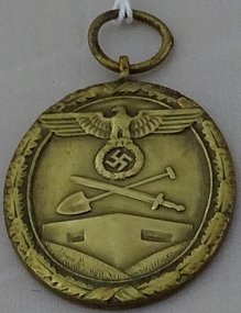
Medal - German
German medal for war effort for the Fatherland. Brass medal depicting an eagle over a swastika, sword and spade. Edged with a leaf design. Small ring attached at the topFur arbeit zum Schutze Deutsch Lands (For work for the protection of German Lands)numismatics, medals, military, german medals, german military medals -
 Bendigo Historical Society Inc.
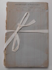
Document - LANDS OFFICE: APPLICATIONS FOR LEASES RECEIVED AT BENDIGO DISTRICT LAND OFFICE, 2/3/1967 - 29/11/1982
Document: hard cover journal with green cover and buff spine and corners. Contains listing of applications received for leases ( type not specified ) in Bendigo area. LH page: number of application, date of receipt, name, postal address, parish. Rh page: allotment, section, area, recommendation and disposal. On spine in red rectangle ' Land Act applications received' Written on front cover in black ink: application register.Lands Office Bendigocottage, miners -
 Bendigo Historical Society Inc.
Document - LANDS OFFICE: INDEX OF CORRESPONDENCE - BENDIGO, 1972 - 1975
Document: hard cover journal, green cover with buff spine and corners. 251 pages. Contains index in front cover and the pages are indexed throughout A - Z. On inside cover is stapled 5 pages titled' Land Office Bendigo' With W nos., LD nos., name in columns. Pages in bound document list: W nos., and folio nos. in first index. Local office no. ( low ) and details of correspondence in second index. Number '12' in top LH corner of cover, and '00' on white label on spine.Lands Office Bendigolands office, bendigo, correspondence. -
Bendigo Historical Society Inc.
Map - PARISH OF SANDHURST 1961, 1961
BHS CollectionAt Bendigo Parish of Sandhurst. Sheet F.Dept of Lands and Surveybendigo, land sales, parish map -
Bendigo Historical Society Inc.
Map - PARISH OF SANDHURST 1961, 1961
BHS CollectionAt Bendigo Parish of Sandhurst. Sheet 13Dept of Lands and Surveybendigo, land sales, parish map -
 Bendigo Historical Society Inc.
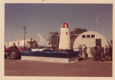
Photograph - SANDHURST BOYS CENTRE COLLECTION: LANDS END FLOAT 1962
Coloured photograph of 1962 float "Lands End".bendigo, institutions, sandhurst boys centre -
 Bendigo Historical Society Inc.
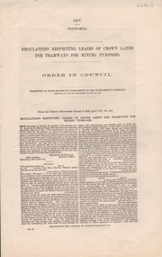
Document - LEASES OF CROWN LANDS FOR TRAMWAYS FOR MINING PURPOSES, 1877
LEASES OF CROWN LANDS FOR TRAMWAYS FOR MINING PURPOSESgovernment, state, mines act, gold mining, tramways, crown land -
 Flagstaff Hill Maritime Museum and Village
Photograph - Historical, Flagstaff Hill, Harbourmaster’s Quarters, 1970s
The photograph shows a cottage, Harbourmaster’s quarters that still stands on the east of the Lady Bay Lighthouse and Historic Precinct at Flagstaff Hill in Warrnambool. The name was changed to the Lighthouse Lodge, and today guests can stay at the property. This photograph, a print, is one of a set of five that show the site of Flagstaff Hill. It is presumed to have been taken by John Lindsay, Founding Director of Flagstaff Hill Maritime Museum and Village. One of the photographs in the set has the pencil inscription "Photo J Lindsay". It was taken in the early 1970s during the initial stages of the development of Flagstaff Hill as a Museum and Maritime Village. The photographs belonged to the donor's grandparents, who lived in the Warrnambool district of Allansford/Naringal. The photograph is a record of the site and surrounds of Flagstaff Hill Maritime Museum and Village before its development and opening in 1975. It shows the cottage on the east of the Lighthouse Complex,. The building is now known as Lighthouse Lodge. The photograph is significant for recording the location and condition of the residence on the Hill.Coloured photograph, glassy print, one of a set of five. Photograph shows the cream timber cottage, Harbourmaster’s quarters to the east of the lighthouse complex at Flagstaff Hill, Warrnambool. On the left of the red roofed residence are iron buildings used, at the time, by the Lands Department. The photograph's paper has the printer's watermark on the back. The early 1970s photograph is presumed to have been by John Lindsay, Warrnambool.Label on the back: "WOODEN RESIDENCE TO THE EAST OF THE PROPERTY / The gun emplacements are immediately behind, and the iron huts to the left rear of the residence are used by the Lands Department who plan to vacate, for other premises."flagstaff hill, flagstaff hill maritime museum and village, warrnambool, maritime museum, maritime village, great ocean road, shipwreck coast, 1970s, photograph, flagstaff hill site, john lindsay, cannon emplacement, residence, wooden residence, timber residence, iron huts, lands department -
 Bacchus Marsh & District Historical Society
Map, Coimadai Parish Map, County of Bourke. Circa 1890s-1900s
The cadastral Parish of Coimadai, a subdivision of the County of Bourke, lies directly north of the township of Bacchus Marsh. The date of this map is uncertain. T.F. McGauran the person who made a photo-lithographic copy of the map was in charge of photo-lithography at the Victorian Department of Lands and Survey in the late 19th century until about 1910.A single page paper map showing the map for the Parish of Coimadai in the County of Bourke. A cadastral map showing parish boundaries and land ownership. A rectangle shaped area is missing from the centre of the map due to a tear or deliberate excision. The map is pasted into a bound volume containing 76 maps or plans in total. High resolution digital image stored on BMDHS computer network. Photo-lithographed at the Department of Lands and Survey, Melbourne by T.F. McGauran 26.8.[??] NOTE. Photo litho from L.P showing temporary surveys and occupation of land prepared for departmental use onlybacchus marsh region parish plans, coimadai parish maps, coimadai parish plan -
Port Melbourne Historical & Preservation Society
Photograph - Sketch, Track to Melbourne, 1839
Photograph - Sketch - Track to Melbourne 1839. (Lands Department)Stamped on back by the National Library of Australianatural environment -
 Bendigo Historical Society Inc.
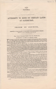
Document - AUTHORITY TO MINE ON CERTAIN LANDS AT SANDHURST - ORDER IN COUNCIL, 1876
AUTHORITY TO MINE ON CERTAIN LANDS AT SANDHURST - ORDER IN COUNCILVictorian Governmentgovernment, state, mines act, bendigo, sandhurst, gold, gold mining -
Port Melbourne Historical & Preservation Society
Document - Notice, Date of deputation to Minister of Lands re sale of lands along Williamstown Short Road, 23 Jan 1880
Pinned with item 600.01Small (4pg) letter from Town Clerk Williamstown to E.C. Clark, notifying date of deputation to Minister of Lands, re sale of lands along Williamstown Short RoadE.C. Clark address is in black (rest of letter in mauve ink)town planning, edward clark, town clerks, george f smith, land sales -
 Department of Energy, Environment and Climate Action
Pye Portable radio and charger
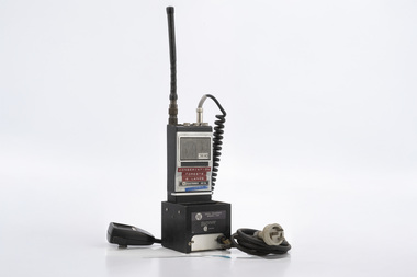
After the 1939 bushfires, the Forests Commission Victoria invested heavily in a radically new communications network. After suffering some inevitable delays due to the war, radio VL3AA switched into full operation in October 1945 proudly beaming out 200 watts across the State. But by today’s standards, the technology was primitive and the reception poor unless the user was on a high point somewhere. The radio signal was "line-of-sight" and bounced between fire towers and relay transmitters across the mountains back to the District offices. The advent of solid-state electronics in the 1960s replaced the more delicate valve sets which enabled greater use of vehicle mounted radios. The Commission continued to research, develop and build new radios at its many workshops around Victoria. The network was supported by a large team of skilled radio technicians. The more secure and versatile State Mobile Radio (SMR) digital trunk system came into operation in about 1995. Upgraded Tait Radios were purchased in 2014 after recommendations of the 2009 Bushfires Royal Commission. But it was the convergence of separate technologies such as 5G mobile phones, high-capacity and light-weight lithium batteries, Wi-Fi, the ever-expanding internet, cloud data storage, digital cameras, GPS, personal organisers and hundreds of supporting Apps into powerful smartphones and tablets which revolutionised bushfire communications from the mid-2000s. Portable radio with handset and chargerConservation Forests and Lands Wangarattabushfire, radios, forests commission victoria (fcv) -
 Bendigo Historical Society Inc.
Book - CROWN LAND SALES: RECORDS OF SALE 1860 - 1865
Land sale journal, blue lined pages, no cover. On top of LH page: Crown Land surveyed in the District of Sandhurst. On top of RH page: Crown Lands sold in the District of Sandhurst' Entries contain details of town lands, suburban lands, country lands, total lands surveyed and date of survey. Date of sale, by auction, by selection and total amount paid. Names of purchasers listed. Entries date from 1860 - 1865. Written across all pages in blue pencil 'Cancelled' and a date for each cancellation: Wm. Rundell 8.9.80.bendigo, land sales, sandhurst -
Whitehorse Historical Society Inc.
Map, Nunawading, Ringwood and Scoresby, 16/02/1858 (original)
Plan of country lands in the Parishes of Nunawading, Ringwood and Scoresby in the Counties of Bourke and Mornington. Lithographed at the Public Lands Office, Melbourne, 16 February 1858. Inset: Pound Reserve, Nunawading.nunawading, ringwood, scoresby, maps -
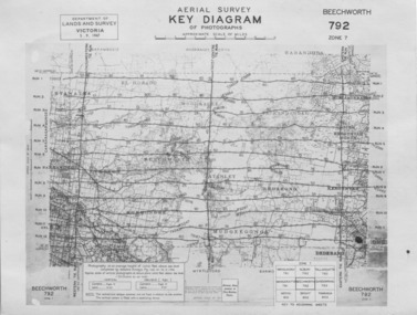 The Beechworth Burke Museum
Photograph - Aerial Survey, 5/9/1947
This image is an Aerial Survey, Key Diagram of Beechworth and surrounding area. Issued by Department of Lands and Survey, Victoria in 1947. Photographed at an average height of 12300 feet above sea level, areas depicted are; Beechworth, Stanley, Bruarong, Baranduda, Muagegonga, Myrtleford, Everton, Wooragee North Tarrawinge, Dederang, Kergunyah North, Kergunyah, Yackandandah, El-Dorado, Barambogie, Murmungee, Barwidgee, Oxley, CarraragarmungeeBlack and white rectangular photograph. Image is printed on matt photographic paper and has a white un-printed border. Obverse: AERIAL SURVEY, KEY DIAGRAM OF PHOTOGRAPHS, APPROXIMATE SCALE OF MILES / DEPARTMENT OF LANDS AND SURVEY VICTORIA 5.9.1947. BEECHWORTH 792 ZONE 7. Reverse: BMM7010.1 (written in pencil) aerial survey, beechworth, burke museum, department of lands and survey, victoria, 1947 -
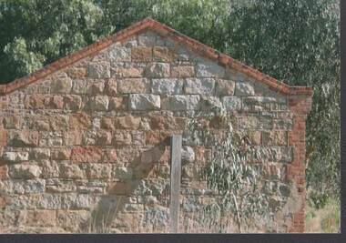
 Bendigo Historical Society Inc.
Photograph - RAVENSWOOD CROWN LANDS
colour Photograph, Ravenswood Crown Lands, Another stone building .photograph, building, ravenswood estate -
Whitehorse Historical Society Inc.
Document, Historical maps and plans, 1855 1889
Copy of catalogue of historical maps and plans - Crown Lands DepartmentCopy of catalogue of historical maps and plans - Crown Lands DepartmentCopy of catalogue of historical maps and plans - Crown Lands Departmentmaps, historical maps -
 Kiewa Valley Historical Society
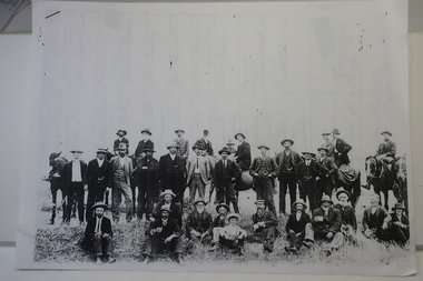
Papers photocopied - photo, list of names, Kiewa Valley Pioneers and Early Activities on the Bogong High Plains
All Early History of the Kiewa Valley. 1. Photo clear but no date. Men named and are residents selecting a site for a bridge at Keegans Crossing 2. Department of Crown Lands letter - 1841 Tawonga pastoral run - Mr James Roberts and Mullindollingong pastoral run 1846 - Mr Patrick Reynolds 3. An account of the Bogong High Plains by W. F. Waters from the late 1890s to 1930s. Published article in the Schuss magazine. August 1958 History of Keegan's Crossing, Kiewa Valley and surrounding residents with names and photos. Early pastoral runs in the Kiewa Valley and Early activities on the Bogong High Plalns..1.The photo includes a listing of residents selecting a site for a bridge at Keegans Crossing. 2. A letter from the Department of Victorian Lands and Survey re early settlers 3. History written in Schuss magaine, Aug. 1958. "In 1896 ... erection of snow poles from Rocky Valley to Tawonga Hut. keegan's crossing, w.f. waters, tawonga and mullindollongong pastoral runs -
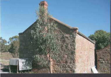
 Bendigo Historical Society Inc.
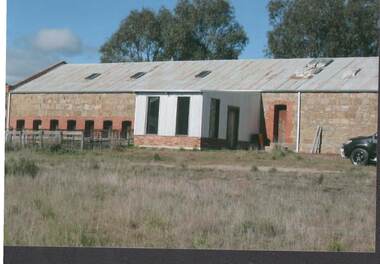
Photograph - RAVENSWOOD CROWN LANDS
Colour Photograph, Ravenswood Crown Lands, Shearing shed with yards at left.photograph, building, ravenswood estate -
 Bendigo Historical Society Inc.
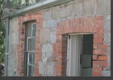
Photograph - RAVENSWOOD CROWN LANDS
Colour Photograph, Ravenswood Crown Lands, window and doorway at the entrance of a building.photograph, building, ravenswood estate -
 Bendigo Historical Society Inc.
Photograph - RAVENSWOOD CROWN LANDS
Colour Photograph, Ravenswood Crown Lands, Part of the Shearing shed on the Estate.photograph, building, ravenswood estate -
 Bendigo Historical Society Inc.
Photograph - RAVENSWOOD CROWN LANDS
Colour Photograph, Ravenswood Crown Lands, Cottage with different style brickwork.photograph, building, ravenswood estate -
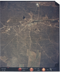 Tarnagulla History Archive
Photograph: Aerial view of Tarnagulla and district, 11th November 1983
Donald Clark Collection. An aerial colour photograph of Tarnagulla and surround lands. Labelled Run 1.tarnagulla -
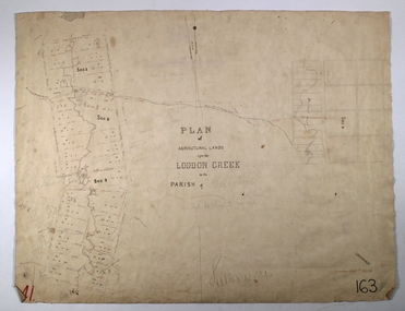 Bendigo Historical Society Inc.
Map - LODDON CREEK, Circa 1860
Map: Plan of agricultural lands upon the Loddon Creek in the parish of Shelbournemap, bendigo, agricultural lands, agricultural lands, loddon creek, shelbourne -
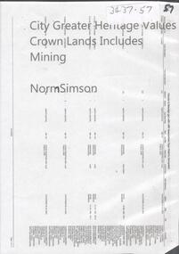 Bendigo Historical Society Inc.
Document - CITY GREATER HERITAGE VALUES CROWN LANDS INCLUDES MINING
DVD. City Greater Heritage Values Crown Lands Includes Mining -
Clunes Museum
Document - LEASE
LICENCE ISSUED TO MR. PATRICK KEIRCE [INCORRECT SPELLING KIERCE] ON 29TH AUGUST 1870PHOTOCOPY OF LEASE OF LANDASSISTANT COMMISSIONER OF LANDS AND SURVEY. BALLARAT.local history, document, lease, kierce, michael mr. -
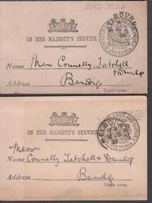 Bendigo Historical Society Inc.
Document - CONNELLY, TATCHELL, DUNLOP COLLECTION: LETTER ACKNOWLEDGEMENT CARDS
2 Buff coloured cards to Connelly , Tatchell & Dunlop acknowledging receipt of letters from Thos. F. Morkham, Secretary for Lands, dated 1898 and 1899. Official stamps on the front -with - Minister of Lands and survey Victoriabusiness, legal, connelly & tatchell -
 Bendigo Historical Society Inc.
Document - DVD OF 1856 PETITION AND INDEX, 1856
DVD/CD. Transcription of names from 1856 Petition from persons at Sandhurst occupying Lands under Business Licenses praying that if the intention of Govt is carried into effect, their lands may be surveyed for sale and the improvements valued.bendigo, law, land improvements