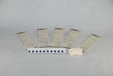
Showing 11171 items
matching maps
-
 Kiewa Valley Historical Society
Map - Topographical, Ski Club of Victoria Bogong High Plains and Adjacent Peaks, Early 1930's
This map has been in the Ryder family for approx. 70 years. Probably used when bush walking and skiing in the early days on the Bogong High Plains. The Ryder family are farmers in the Kiewa Valley and were involved in taking their cattle up to the Bogong High Plains where they had a lease. The State Electricity Commission of Victoria constructed the Kiewa Hydro Electric Scheme opening up the area during the 1940's and 1950's. This type of map is an early one, used by people in the Kiewa Valley and possibly by surveyors prior to construction.The map is an early topographic map used by farmers living in the Kiewa Valley. It is historically significant as these people were involved in taking cattle up to the High Plains during summer and may have been used for bush walking and skiing.This is a sepia coloured paper map which was originally printed copyright registered. It was revised in 20/6.33/4.4.37/8.4.40/24.8.43/19/6/54. It shows roads / tracks / snow poles / snow pole numbers (27) / Snow pole spacing (3 chains. 66 yards) approximately 27 poles to the mile / height above sea level in feet - 5280. Water courses not definitely located etc.Rocky Valley Dam (Kiewa Hydro Electric Scheme) has been drawn on the map by hand with a biro. There is a wooden rod at the top of the map.topographic map; kiewa valley; ryder family; high plains of victoria -
 Greensborough Historical Society
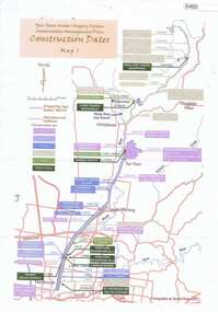
Maps, Yan Yean Water Supply System Conservation Management Plan: Construction dates Map 1, 2007_
... Maps ...Plan of Yan Yean Water Supply System, showing natural and constructed features from 1850s to 1930s from Silver Creek Weirs to Eastern Freeway.Printed in colour one side. 3 copieswater supply, yan yean reservoir, plenty river -
 Greensborough Historical Society
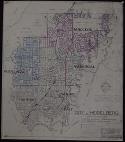
Maps, City of Heidelberg 1974, 1974c
... Maps ...City of Heidelberg showing Municipal and Ward boundaries, prepared by City Engineers Department. Made for Council use; copies available for sale to the public.Blueprint, 2 copies, one with some roads hand coloured, showing municipal and ward boundaries. Scale: 20 chains to 1 inchG. M. Hutchins. Authorised charge 50c.city of heidelberg, heidelberg -
 Greensborough Historical Society
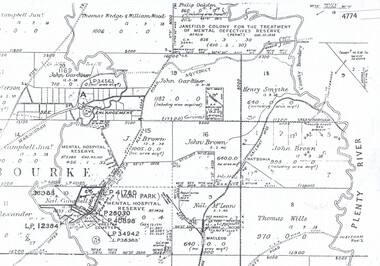
Maps, Greensborough. Parish Plan 1860, 1860c
... Maps ...This plan show Green's subdivision of Greensborough, north of Grimshaw Street.Enlargements of Parish plan circa 1860?One copy possibly from 1860, containing lot numbers for a government road, now Main Street, and surrounding streets.greensborough, grimshaw street greensborough, edward bernard green -
 Greensborough Historical Society
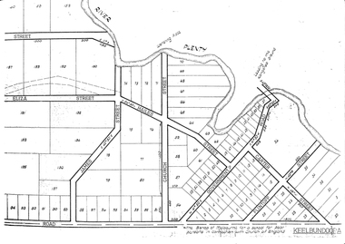
Maps, Greensborough west of Plenty River, 1840o
... Maps ...Areas of Greensborough, west of the Plenty River, showing land holdings in the 1840s. Comprises Sections 8, 9, 10, 14, 15, 16, 17, 18, 19, 20 Parish of KeelbundoraOne A4 photocopy, one A3 enlargementgreensborough, watsonia, lower plenty, janefield -
 Gippsland Vehicle Collection
Maps
... Maps ... -
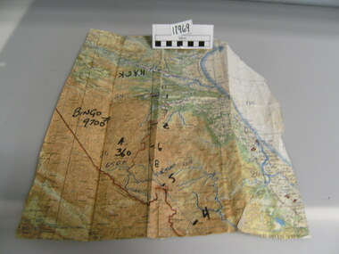 National Vietnam Veterans Museum (NVVM)
Map
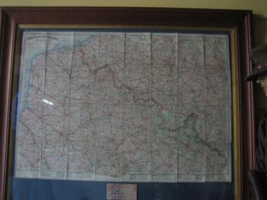
A very damaged well used map which has been jointed together. It appears to be Northern Section of vietnam with numbers written in black texta (Hack, Bingo 9700) on front.On back of map hand written "Mission into the North. Planned both directions".Topagraphical Mapmap, alan reed -
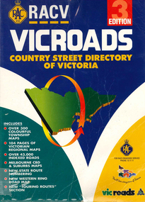 Victorian Aboriginal Corporation for Languages
Book, Royal Automobile Club of Victoria, Vicroads country street directory of Victoria, 1997
Country street directory which contains maps, lists, and tourist information.Maps, colour photographsroad maps -
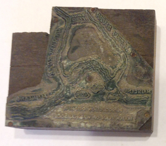 Warrnambool and District Historical Society Inc.
Functional object - Printing block: Warrnambool Historical Society logo, 1980s
This printers block was made for the Warrnambool and District Historical Society and used to print letterheads, envelopes and cards. The impression on the block is of the sketch map drawn by Thomas Price of Port Fairy of the Warrnambool Harbour site when he wrote to Superintendent Charles LaTrobe in 1844 regarding the suitability of the site for a new town. The letter is regarded as an important impetus for La Trobe to consider establishing the town of Warrnambool and so the sketch was used by the Historical Society as its logo on letterheads etc for many years. It was also used as the heading for the Society newsletters from the late 1980s to late 2007.This block of the Thomas Price sketch was used by the Historical Society for many years for its printed material and the sketch was used as its logo for about 20 years so it is an important part of the Society’s history and the block is kept as a reminder of this.This is a printing block with an impression made of metal and attached to a wooden block. The wood is in layers of dark and light coloured wood and has a piece cut out at the top left hand corner. The impression is a representation of the sketch map of Warrnambool Harbour made by Thomas Price in 1844.Sketch map of Warrnambool Harbour 1844warrnambool & district historical society, thomas price sketch -
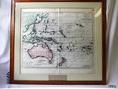 Flagstaff Hill Maritime Museum and Village
Map, Australien (Sudland) auch Polynesien oder Inselwelt, insgemein der funfte Welltheil, c.1990
This map is a reprint of Johann (Johannes) Walch’s “Australien (Sudland) auch Polynesien oder Inselwelt, insgemein der funfte Welltheil”, published in 1802. It shows Australia, New Zealand, South East Asia and the Pacific Islands shows a large number of places names, many of which have changed since the map was drawn. The map includes the routes and dates of the voyages of Tasman, Cook, Bougainville, Carteret, Byron, and others up to 1802. The shapes of the lands on this early map show that some of the areas had not yet been charted. The map was donated to Flagstaff Hill Maritime Village in April 1990 by the Group Study Exchange Team from Rotary District 233, Sweden. It was framed and presented by Rotary District 978 and presented by Barry Lange, the Governor of District 978 in 1989-90. (District 978, Geelong East, is now District 9780.) Johann (Johannes) Walch Johann Walch, painter and engraver, was born in 1757. He was well known for creating miniature portraits. He gained his training in Geneva, Venice and Rome. His publications include atlases and sheet maps, many of which were reprinted after his death in 1816. This reprint of an 1802 is significant for its historical and geographical contant, showing the voyages of many early explorers to the southern regions of the world including Australia. It also shows the early names used for countries and towns and is a valuable reference to historical interpretation. The map itself is a fine example of hand drawn and hand coloured maps of the early 19th century, the method of production, detail included, layout, symbols and so forth.Map, reprint of Johann (Johannes) Walch’s “Australien (Sudland) auch Polynesien oder Inselwelt, insgemein der funfte Welltheil “, first published by in Ausburg in 1802. The image on this Map No 5B, shows Australia and the south Pacific. The timber framed, glass covered, printed and coloured map was created in two sections and joined. Brass plaque at base of map states that the map was presented to Flagstaff Hill by Rotary International in April 1990. Feint lines used for aligning lettering can be seen on the map and there are large erased letters such as a “D” and “S” that are almost obscured.Plague “ROTARY INTERNATIONAL / THE MAP WAS DONATED BY THE GROUP STUDY EXCHANGE TEAM / FROM ROTARY DISTRICT 233 SWEDEN IN APRIL 1990 / AND WAS FRAMED AND PRESENTED BY ROTARY DISTRICT 978 / BARRY LANGE – GOVERNOR DISTRICT 978 1989/90” Stamped on back “ELLIMINOOK FRAMES / MRS. JILL FALKINER / ELLIMINOOK / BIRREGURRA, VIC. 3242 / PHONE: (052) 36 2080” flagstaff hill, warrnambool, shipwrecked coast, flagstaff hill maritime museum, maritime museum, shipwreck coast, flagstaff hill maritime village, great ocean road, australien (sudland) auch polynesien oder inselwelt, insgemein der funfte welltheil, johann (johannes) walch, cartographer johann (johannes) walch, ausburg publisher johann (johannes) walch, johann (johannes) walch map number 5b, 1802 map of australia and south pacific, rotary international group study exchange team, rotary district 233 sweden, elliminook frames, voyages of tasman, voyages of cook, voyages of bougainville, voyages of carteret, voyages of byron, barry lange, painter of miniature portraits johann (johannes) walch -
 Phillip Island and District Historical Society Inc.
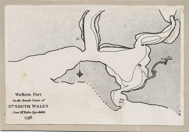
Photograph, Bryant West, 1798
... maps ...One of a collection of over 400 photographs in an album commenced in 1960 and presented to the Phillip Island & Westernport Historical Society by the Shire of Phillip IslandPhotograph of the First Map of Phillip Island ever drawn. An eye sketch by Bass.As written on front of map - "Western Port on the South Coast of Nw. South Wales from GE Bass's Eye-sketch 1798"local history, photography, photographs, exploration, maritime, documents, maps, george bass, phillip island, bryant west, john jenner -
 Wodonga & District Historical Society Inc
Map - Tulloch & Brown's Map of the Colony of Victoria, Tulloch & Brown, 1856
The map was created by Tulloch and Brown. David Tulloch was one of the earliest engravers and lithographers in the state of Victoria. He arrived in Melbourne from Greenock, Scotland, on 3 January 1849. Following the discovery of gold Tulloch went to the Victorian goldfields in 1851, commissioned to make sketches of the diggers and the diggings for Ham’s Illustrated Australian Magazine. In November 1852 Tulloch set up in business as engraver, draughtsman, copperplate printer and lithographer. Tulloch took a map engraver, James Davie Brown, into partnership in March 1853; the several maps and specimens of commercial engraving they showed at the 1854 Melbourne Exhibition were awarded a bronze medal. That year Tulloch and Brown also received a silver medal at the Victorian Industrial Exhibition. The partnership was dissolved towards the end of 1856.This is a very early map of the Colony of Victoria including Belvoir (now know as Wodonga).A foldable map mounted on linen and with a board cover. It records the Colony of Victoria according to Surveyor's Records revised in 1857. Areas of the map are shaded to highlight different counties.At bottom right hand section of map: Tulloch & Brown's map of the Colony of Victoria : comprising part of New South Wales, the boundaries, counties, also seaport & inland townships, the gold fields with the latest discoveries, roads, tracks, &c. &c. / compiled from drawings in the Survey Office and correctly revised till 1857. Respectfully dedicated by Permission, to the Honorable Captain Andrew Clarke R.E. Surveyor General of Victoria by His Obediant Servants Tulloch & Brown, Engravers & Publishers, Melbourne". At bottom right below border : Published as the Act directs by the Proprietors, Melbourne, 1st Feb. 1856. tulloch and brown maps, rare maps victoria, victorian cartography -
 Yarra Glen & District Historical Society
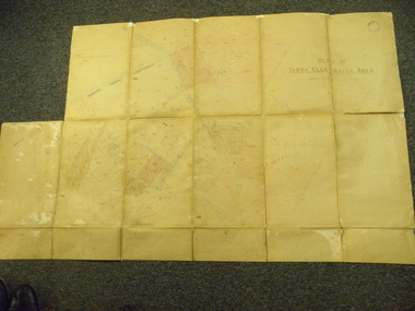
Map, Plan of Yarra Glen Water Area
The map has been used by water supply officers to map the supply of water to properties in the township area of Yarra Glen.The item is significant because it records changes to the supply of water to Yarra Glen over a period of approximately 100 years. It also records property owners and subdivisions.Flat map which folds into 12 pages with a dark red cloth cover. One page in top left corner is missing. Scale of the map is 300 feet to an inch. Cream coloured packing tape has been placed along the back of the folds and is now peeling off.Round stamp in top right corner "Shire of Eltham". Pencil note on top left existing page "Note - includes record of 8 LP's subdivisions. HC". Information has been added to the map over an extended period of time in red ink, black pencil, blue pencil and blue biro.yarra glen/water supply/ -
 Victorian Aboriginal Corporation for Languages
Map, Country Fire Authority, Regions 23 and 24 north east rural directory, 1998
... maps ...mapswodonga, albury, wangaratta, benalla, maps, victoria, fire protection -
 Running Rabbits Military Museum operated by the Upwey Belgrave RSL Sub Branch
Map
... Maps ...Map of the Western Front WW1maps -
 Victorian Aboriginal Corporation for Languages
Book, New South Wales Aboriginal place names and euphonious words, with their meanings, 1959
Includes map of NSW tribes, and numerical cross-referencing to those tribes if the language of the place name is known.Maps, word lists -
 Bendigo Historical Society Inc.
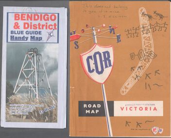
Map - Road maps
BHS CollectionTwo road maps. On, Bendigo & District blue guide handy map the other a road map of Victoria. On the back of the Bendigo map the date October 2000. On the Victoria map the words in pen "This doesn't belong to you, it is mine". L.J. Ellison and a blue stamp of Axedale service station. Aileen and John Ellison Collection.road map, victoria, bendigo -
 Bendigo Military Museum
Literary work - 38th BN ON THE SOMME, 1).2) 1918, .3) system generated
... Maps ...The story covers mostly men of C Coy 38th Bn as well as others to give a broader pictutre. Edgar Stanbury MM as a C Coy Scout retrieved the maps from Capt G.A Dutton who was KIA. Stanbury then proceeded to keep reconnoitering towards Clery until they reached trenches near Clery Copse. The photos relate to the following, Jack Grinton, Bert Grinton, Edgar Stanbury, C.E. Newton, D.T.Hull, A.E.Pegler, Albert Gilhooley, C.E.A.Dunn, Hugh Pippin, G.A.Dutton, C.J.Holmes, Capt Selleck, Major Maudsley, last photo is labelled “Past Clery Copse”. Jack Grinton No 1043 C Coy, refer Cat No 1280. Bert Grinton No 5024 C Coy, awarded DCM 31.8.1918, refer Cat No 1320P. Edgar Stanbury No 997 C Coy, awarded MM 1917, WIA 2nd occasion 31.8.1918, refer Cat No 5032.3P. Charles Newton No 951 C Coy, awarded MM 26/31.8.1918. David Hull No 904 C Coy, Gassed 24.8.1918. Albert Gilhooley No 890 C Coy, KIA 31.8.1918, refer Cat No 5047. Augustus Pegler No 967 C Coy, awarded MM 31.8.1918. Cyril Dunn No 3058 7th Reo’s C Coy, KIA 31.8.1918. Hugh Pippin No 1895 2nd Reo’s C Coy, WIA 2nd occasion 11.8.1918, refer Cat No 1502. George Dutton Lieut No 532 C Coy, KIA 29.8.1918. (Photo of his name on Map & note to Jack Grinton) Charles Holmes No 910 C Coy, KIA 24.8.1918. (Photo of original grave) Horace Selleck Capt C Coy, KIA 19.7.1918, refer Cat No 1515. (Photo of address book) Arthur Fyfe No 1841 2nd Reo’s C Coy, KIA 30.8.1918. (Photo of original grave) Arthur Maudsley Major D Coy, KIA 31.8.1918. (Photo of original grave) Fyfe, Maudsley and Duttons graves are in the one photo. Last photo labelled “Past Clery Copse” This is the area where Bert Grinton is awarded the DCM on 31.8.1918, photo was taken by his brother Jack. .1) Map of France, trenches corrected to 15.4.1918, 1/20,000, Sheet 62D N.E, covers an area from Ribemont to Bray. .2) Map of France, trenches corrected to 6.3.1918, 1/20,000, sheet 62C N.W, covers area from Suzanne to Mt St Quentin. Both maps follow the Somme River. .3) Photo - story covers the events relating to the two maps from July 17th. - Sept 1st 1918 on the Somme . There are 14 photos with the story, 3 sections make up the story, Map 1, Map 2 and then details on the advance, the men, casualties and other.maps, 38th bn, c coy, the somme -
 Victorian Aboriginal Corporation for Languages
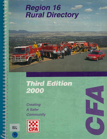
Map, Country Fire Authority, Region 16 rural directory, 2000
... maps ...maps, colour photographsararat, fire protection, emergency services, maps, victorian regional maps -
 Victorian Aboriginal Corporation for Languages
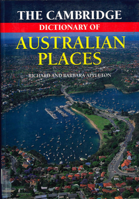
Book, The Cambridge dictionary of Australian Places, 1992
... maps ...Lists thousands of place names across Australia, giving a detailed account of the name and location, shire etc.maps, pronunciation guidesgazetteer, nomenclature, maps, geography, pronunciation -
 Victorian Aboriginal Corporation for Languages
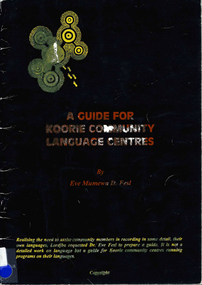
Book, Eve Mumewa D Fesl, A guide for Koorie community Language centres
Looking at maps and word lists that record the use of languages and dialects in the areas. Gives tips for recording languages and language lists.Maps, word listskulin, ganai, wadi wadi, wemba wemba, wergaia, yorta yorta, dadi dadi -
Victorian Aboriginal Corporation for Languages
Book, Leon Costermans, Trees of Victoria and adjoining areas, 1994
Format features leaf identification, map of location, seeds and bark etc., in black and white drawings.Colour photographs, illustrations, mapstrees, east gippsland, south coast nsw, mallee -
 Melbourne Tram Museum
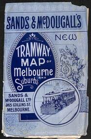
Map, Sands McDougall, "Tramway Map of Melbourne and Suburbs", c1906
... maps ...Shows railways, cable and electric tram lines c1906. One of a number of maps produced by Sands McDougall of Collins St. Includes the MTOCo horse tram lines and the Caulfield horse tram lines. See items 2885 and 6573 for other editions. Yields information about Melbourne c1906 and its public transport lines. Map - folded sheet of paper 5 sections wide x 4 sections or folds deep contained within a light grey paper cover titled "Tramway Map of Melbourne and Suburbs"maps, melbourne, cable trams, tramways, railways, horse trams, nmetl, vr trams, sands mcdougall -
 Bendigo Military Museum
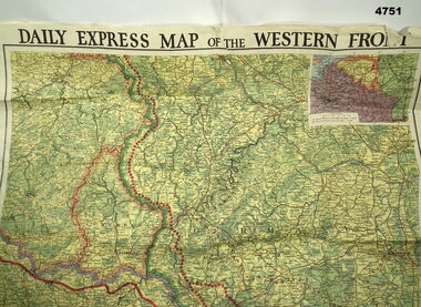
Map - MAP of the WESTERN FRONT, Post 1918
... Maps ...Map, “Daily Express map of the Western Front, colours greens, yellows & orange, the Western front is shown as red dots, inset in corner of areas, section of the map is missingmaps, western front -
Clunes Museum
Map, Oct-74
... MAPS ...MAP OF CLUNES STREETS/TOWNSHIP - SCALE IN CHAINSlocal history, document, maps, maps -
Whitehorse Historical Society Inc.
Map, Box Hill in 1883, c1933
... Maps ...Map of Box Hill in 1883 showing churches, hotels, etc, linked to ND 4231 '1933 map'Map of Box Hill in 1883 showing churches, hotels, etc, linked to ND4231 '1933 map'Map of Box Hill in 1883 showing churches, hotels, etc, linked to ND 4231 '1933 map'maps, box hill -
 Bendigo Military Museum
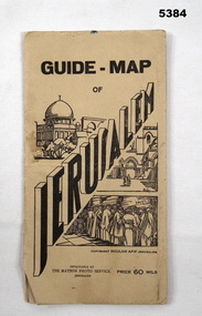
Booklet - GUIDE MAP OF JERUSALEM, The Matson Photo Service,Jerusalem
This item was souvenired by Pte VX 59037 L. E. Anderson, 3rd Aust Ord W. Shops Comp A15, Beirut, SyriaCream cardboard covers with black printing and sketch of buildings and people praying at the wall. Back cover has a map of Syria on the inside. Folded map coloured red and yellow on cream paper. Back of map has black printing explaining different places and Jerusalem and a photo of the Australian Soldiers Club Jerusalem."Guide Map of Jerusalem." Price 60 mils.jerusalem, map, ww2 -
Creswick Campus Historical Collection - University of Melbourne
Map, 1937-1942
Linen backed topographical Maps - Victoria. 26 folding mapsMapsSchool of Botany, Univerity of Melbourne -
Creswick Campus Historical Collection - University of Melbourne
Map, 1937-1942
Linen backed topographical Maps - Victoria. 21 folding mapsMapsSchool of Botany, Univerity of Melbourne -
 Seaworks Maritime Museum
Selangor Pewtor map, Possibly Malaysia
Commemoration of the maiden voyage of the M.V Bunga Kenari.Selangor Pewter Map of East Indies. Original map was created in 1700s and this reproduced pewter map was based upon originals in the Collection of Muzium Negara, Malaysia. The map is framed in a dark wood frame with pewter flowers decorating each corner.On the verso: PMA0299 Text located on map: ‘A NEW MAP OF THE EAST INDIES…’ ‘Reproduced from the collection of Muzium Negara, Malaysia. Selangar Pewter.’ On plaque: ‘IN COMMEMORATION OF THE MAIDEN VOYAGE OF/M.V BUNGA KENARI/MELBOURNE’gifts