Showing 8399 items matching "mckillops-bridge"
-
 Clunes Museum
Photograph
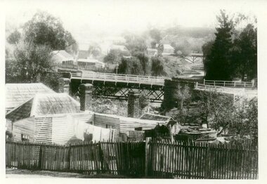
PHOTOGRAPH TAKEN LOOKING DOWNSTREAM TULLAROOP CREEK, ABOUT 1900. GOVERNMENT BRIDGE IN FOREGROUND, JULILEE BRIDGE IN MIDDLE DISTANCE, PORT PHILLIP MINE POPPET HED IN DISTANCE..1 ORIGINAL PHOTOGRAPH OF GOVERNMENT BRIDGE AND JUBILEE BRIDGE. TAKEN FROM CREEK PARADE. THE GOVERNMENT BRIDGE WAS BUILT CIRCA 1900. .2 ENLARGED PHOTOCOPY IN HANDWRITING : LOOKING DOWN-STREAM TULLAROOP CREEKABOUT 1900 GOVERMENT BRIDGE IN FOREGROUND JUBILEE BRIDGE IN THE MIDDLEbridges, jubilee bridge, goverment bridge -
 Greensborough Historical Society
Slide - Photographic Slide, Swing bridge Greensborough, 1974
View of swing bridge Greensborough following 1974 Plenty River flood. Includes Diamond Valley Council clean-up crew of Lindsay Millington and M. SmeadKodachrome colour photographic slideHandwritten on mount: "Swing bridge Greensboroiugh; 1974 flood; L Millington; M Smead"plenty river flood, swing bridge greensborough, lindsay millington -
 Eltham District Historical Society Inc
Photograph, Oxley Bridge construction, Henley Road, Kangaroo Ground, 1962, 1962
This is copy of a photograph taken 1962, during the construction of Oxley Bridge at Kangaroo GroundBlack and white photograph of Oxley Bridge construction over Watsons Creek, Henley Road, Kangaroo Ground, circa Aug-Sep 1962kangaroo ground, oxley bridge, watsons creek, henley road, bridges -
 Phillip Island and District Historical Society Inc.
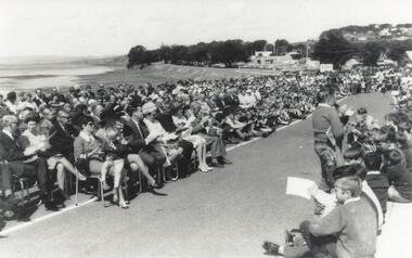
Photograph, Phillip Island Bridge Opening, 1969
Official Opening of 2nd San Remo - Newhaven Bridge, 1969 by Hon. Porter, Minister of Public Works. From the Jack Jenner Collection.Large crowd, some seated, on road approach to New Bridge San Remo side, on day of Opening 1969.local history, photographs, civil engineering, bridges, phillip island bridge, black & white photograph, jack jenner collection, phillip island bridges, public construction -
 Ballarat Heritage Services
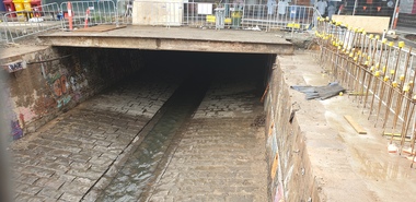
Photograph, Clare Gervasoni, Uncovered Bridge in Bridge Street, Ballarat, 2024, 01/12/2024
Photographs of the uncovered bridge that runs through Bridge Street, and through two covered shopping precincts.bridge street, bridge, ballarat -
 Sunbury Family History and Heritage Society Inc.
Photograph, Bulla Bridge, 12 July 1944
The photograph was taken looking across the Deep Creek valley with the three-arched stone bridge spanning the river.A black and white photograph with a white border of a deep river valley with a three-arched bridge spanning a river. A gum tree is in the foreground. -
 Tarnagulla History Archive
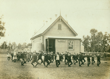
Photograph of students exercising at Arnold's Bridge School, Students exercising at Arnold's Bridge School, c. 1911-1920
Murray Comrie Collection. The school was established as Arnold State School, changed to Arnold's Bridge School in 1892 then back to Arnold in 1920. A monochrome photograph depicting children exercising outside Arnold's Bridge School. Mounted onto heavy dark brown card. Handwritten on reverse: information about changes to school. No names.schools, children, arnold, arnold's bridge -
 Port Fairy Historical Society Museum and Archives
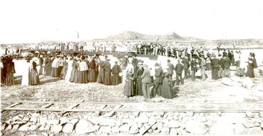
Photograph, Opening of bridge over South West Passage 1887, 1887
The opening of the bridge over the South West Passage would now allow the lighthouse keeper to walk between the island and the mainland carrying his produce and herding his cattle rather than loading a boat to transport everything. This would also allow the public access to the island for fishing. Black and White Photograph of Opening of bridge over South West Passage 1887events, civil, ceremony, griffith island, rail, bridge -
 Ballarat Heritage Services
Photograph - Photograph - Colour, Sunnyside Mill Bridge over the Yarrowee, Hill Street, Ballarat, 2016, 17/09/2016
"A joint meeting of city and town ratepayers, convened by Messrs Francis Jago and Henry Johns, interested in the formation of a cart bridge in Hill street, over the Yarrowee Creek, was held on Saturday evening, in the Societies Hall, corner of Skipton and South streets, with the view of taking united action in the matter. Mr Morris was voted to the chair, : and about 60 persons were present. The chairman stated that the object of the meeting was that united influence should be brought to bear upon the City and Town Councils, so that a cartbridge should be erected. He said that Mount Pleasant would no doubt be thickly populated in a few years, and the bridge would prove a great boon to the inhabitants of the locality. By means of a cart bridge drays, would be enabled to save on their journeys to and fro between the mount and the batteries, at least a mile and a half each time. He hoped that the councillors for the south ward would assist them in this matter. Mr Jago, as one of the conveners of the meeting, said that united action on the part of both eastern and western ratepayers was requisite, so as to exert a strong pressure upon the City and Town Councils, in order that the work should be carried but. Mr Grainger moved the first resolution as follows;—“ That the construction of a cart bridge over the Yarrowee Creek at Sunnyside, to facilitate communication between the residents of the city and town, is urgently necessary, and that in the interests of both municipalities the two councils be asked to at once jointly carry out the work. In doing so he said that the necessity of a cart-bridge for the residents of Mount Pleasant would be apparent when the number of batteries, tanneries, and also the Woollen Mill, in the district were considered. The place was of growing import ance, and ready communication should at once be established. Another reason was that an immense saving in time would be effected. It was quite a common occurrence to see one, two, or three drays stuck in the bed of the creek which had gone that way to make a short cut. Now, what with the horses floundering about and breaking their harness, it seemed a wonder to him that life had not been destroyed before now, just through the want of a cartbridge. Mr Johns seconded the resolution. Mr Robert Calvert supported the resolution, and said that it was disgraceful action on the part of the representatives of the south ward that the work had not been executed long ago. They should come together like men and demand that the work should be done, and if not done they should not pay rates until it was. (A voice—“But they’ll make us.” Laughter.) The wooden footbridge across the creek was “only a wooden fabric, not fit for a Christian to walk across, and steps should be taken to remedy this also. Mr Blight, a resident of Mount Pleasant, said that, in common with others, he had been opposed to the erection of the bridge two years ago, but his views had since been altered. Cr. Morrison, who was present, said that the fault of the cartbridge not being erected over the Yarrowee at Hill street lay not with the City Council, but with their neighbors, who had always been opposed to its erection there. In 1874 a motion was carried at a meeting of ‘the City Council" by which the sum of £5OO had been voted to carry but the work. As the bridges over the Yarrowee were joint undertakings of the city and town, they had, by the provisions of an act of Parliament, called upon the Town Council to assist them in the erection of the bridge. In consequence, a conference of the two corporate bodies had taken place, when a motion was moved by Cr Howard, the representative of the south ward, and seconded by Cr Turpie, of Ballarat East—“ That the bridge should be erected at Hill street.” The motion was rejected, principally through the eastern representatives, who wanted the bridge lower down. Since then the two councils had often met to consider, the question of bridges over the Yarrowee Creek, but nothing had been done at the meetings, as the Eastern Council wanted the bridge in one place and the City Council in another. He had himself, when first elected to the council, given notice of motion affirming the desirability of a bridge, at the place now fixed upon. The Woollen Company was growing in importance, and a direct, road to its works would greatly advance its interests. For the working, expenses of each ward £400 was annually, appropriated; and this amount would not be sufficient carry out the work. They would have to obtain a special grant of about £900, as Hill street would require a culvert to be erected therein, as now it was virtually an open drain which carried the drainage of the western plateau to the Yarrowee. He advised that strong pressure should be exerted, specially upon the Eastern Council, and then the work might be carried out. He thought that if the foot bridge was repaired, and large stones thrown into the creek, it would do until the bridge could be erected. The chairman then put the resolution, and it was unanimously carried. Mr Hamilton moved the second resolution— “That Messrs Fern, Greenwood, Peirce, and Jago be deputed by the meeting to wait upon the City and Town Councils and present the first resolution; also that petitions in its favor be signed by all ratepayers interested.” Mr Haigh seconded the resolution, which was carried. Votes of thanks to Cr Morrison for his attendance, and to the chairman for presiding, were passed, and the proceedings terminated." (Ballarat Star, 9 August 1881, page 3) "WOOLLEN MILL BRIDGE YARROWEE IMPROVEMENTS Though brief the official ceremony of opening the bridge across the Yarrowee Creek, near the Sunnyside Woollen Mills, was of an interesting character. It took place at noon yesterday in the presence of the Mayors and councillors of the City and Town. Hon. F. Hagel thorn (Minister of Agriculture).Hon Brawn. M.L.C., Lt-Col Morton (Acting City Clerk). Mr J. Gent (Town Clerk of Ballarat East), Mr A. Farrer (City Engineer), Lt. L. Finch (who is about to leave for the Front, and who assisted Messrs A. Farrer and G. Maughan in carrying out the project, Mr W. Hurdsfield (Clerk of Works) and others. An apology was received from Mr J. McClelland, contractor for the work. Mayor Hill expressed pleasure in Introducing Mr Hagelthorn, who had at great personal sacrifice and inconvenience come from Melbourne to perform the opening ceremony of that beautiful bridge, which was of great improvements that had been effected.When Mr Hagelthorn was Minister of Pubic works he visited Ballarat specially to see the condition of the creek, which at that time was in a disgusting state from a sanitary standpoint. After viewing the position, and realising the justice of the claim. Mr Hagelthorn made strong representations to the Government of which the was a member with the result that it voted £17,000 for the work. That action had been the means of turning a plague spot into a thing of beauty. They therefore owed a deep debt of gratitude to Mr Hagelthorn and the Government of which he was a member, and they were particular grateful to Mr Hagelthorn for coming to Ballarat to perform the open ceremony. Mayor Levy said he could bear testimony to the good work Mr Hagelthorn had always done for Ballarat. In him Ballarat and district always had a good friend. He thought Mr Hagelthorn would feel amply gratified at seeing the good work that had been done. It would serve as some reward for the expenditure, on behalf of the residents of Bal larat, of the amount of money made available through Mr Hagelthorn's instrumentality for the two municipalities. Otherwise the City and Town councils would not have been able to carry out so necessary and so beneficial a work. There was a great amount of work yet to be done, and when the financial market became low stringent Mr Hagelthorn would no doubt be pleased to take the necessary steps to have money provided for further works which could not be undertaken at the present time. The adjacent woollen mill was a standing monument to what was being done in Ballarat, and what ever the City and Town Councils or the Government could do to encourage such manufacturing enterprise should be done, and he was glad to be able to say that was being done as far as finances would permit. He concluded by presenting Mr Hagelthorn with a gold mounted pocket-knife with which to cut the ribbon stretched across the centre of the structure as a bar to traffic. The Hon. F. Hagelthorn, who was greeted with applause said before him was a good work well done in the interests of the public. Real prosperity could only be achieved by a movement carried out by the people to increase natural productiveness. Most of them had been made aware, on account of the war par tiularly, that the people who were best equipped, the industries that were best organised, and the Governments that were most intelligently controlled would get the most of this world's goods and some of its luxuries that Would be denied other people less efficient. Any thing the Government could do to promote industry and to increase the reward of those engaged in it, both employer and employee, would be done. Most Governments would do but little in that regard. ... " (Ballarat Courier, 13 September 1916, page 4)Bluestone and iron bridge over the Yarrowee River at Hill Street, Ballarat.sunnyside mill, sunnyside woollen mill, ballarat woollen mill, bridge, yarrowee creek, francis jago, mount pleasant, yarrowee river, robert calvert -
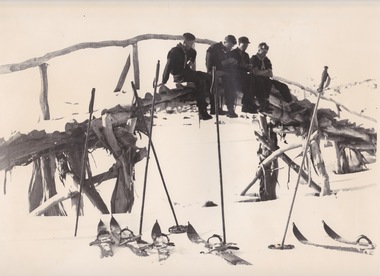 Falls Creek Historical Society
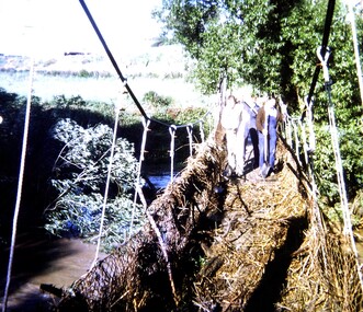
Photograph - Harbour Bridge over Watchbed Creek
The late W.F. “Bill” Waters, Rover Commissioner of Victoria, was introduced to skiing in November 1930 at the International Scout Chalet at Kandersteg in Switzerland. He believed it would be a good activity for Victorian Rovers to be involved in to learn more about the Victorian Alps The first Rover ski trip to the Bogong High Plains was in the August of 1932 when a group of four crossed the High Plains from Omeo to Harrietville via Tawonga Huts, Cobungra Gap, Mt Loch and Mt Feathertop. In 1933 the Bogong Rover Crew was formed and in 1938 funds were collected and life memberships offered to raise funds to build a Rover Chalet for the purposes of skiing. During February and March1940, the Chalet was built at a cost of £700 using volunteer labour. It was the first ski lodge in the area and was built long before there was a road over Watchbed Creek. After the road to Rocky Valley was finished it was easier for the scouts to walk in from there instead of from Shannonvale. During the spring thaw the creek became almost impassable. Joe Holsten who was an SEC employee who worked with Martin Romuld out of Wilkinson’s Hut built a bridge across the creek made entirely from snow gums which he had to haul about 300 metres from the nearby hills. It became known as the Harbour Bridge as it arched over the water just like the Sydney Harbour Bridge.These images are significant because they depict an early bridge structure to enable easier travelling across the Bogong High Plains.Three black and white photos taken at the Harbour Bridge, Watchbed Creek.harbour bridge bogong high plains, watchbed creek, joe holsten -
 Whitehorse Historical Society Inc.
Article, Bridge Plan under fire, 2016
Whitehorse Council has demanded a meeting with Planning Minister Richard Wynne.Whitehorse Council has demanded a meeting with Planning Minister Richard Wynne after he controversially approved Deakin University's plan for a bridge in a Burwood Park.Whitehorse Council has demanded a meeting with Planning Minister Richard Wynne. city of whitehorse, deakin university burwood campus, burke, anna, wynne, richard -
 Stawell Historical Society Inc
Photograph, Tobacco Farming at Dadswells Bridge c1932
Five Adults, two of them men holding Tobacco Leaves at Dadswells Bridge circa 1932. Charlie Pickering with the tobacco leaves & L I Anderson. From Dave Rudolph's old photographs.Back Of photo Dadswells Bridge c1932 Charlie Pickering L I Anderson Tobaccofarming -
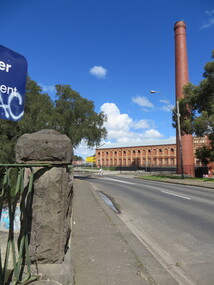
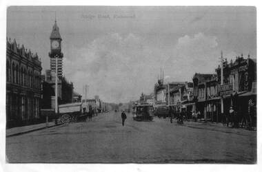 Melbourne Tram Museum
Photograph - Enlargement of a postcard, Bridge Road Richmond, c1900
The first image shows the shops on either side of Bridge Road with horse drawn carts and one cable tram. The second image from the Town Hall tower, shows two cable tram sets, the narrowing of the road. Has in the view Guddon & Selleck Auction House and Property Exchange also advertising Commercial Union Assurance Co. and George Stirling and Sons store.Yields information about Bridge Road, c1900Set of two A3 enlargements of postcards 1 - Looking east along Bridge Road from near Church St 2 - Bridge Road Richmond - from Town Hall looking westcable trams, tramways, richmond, bridge road, -
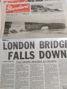 Peterborough History Group
Newspaper, London Bridge Falls Down, 16th January 1990
The collapse of one arch of the London Bridge rock formation on January 15th 1990 was a significant event for Peterborough residents.London Bridge is a major local tourist attraction. Prior to the collapse tourists could walk across the arches onto the rock platform and it was a regular fishing spot. The collapse of the arch was a significant event for the town. The site is still an important tourist stop. The rockfall occurred after two recent events - a helicopter hit the arch and crashed, no one injured; and the earthquake in Newcastle NSW.Two full page articles about the rock formation London Bridge falling down, and the people who were stranded on the rock platformlondon bridge, london bridge rock formation, rock collapse, great ocean road, peterborough -
 Ballarat Heritage Services
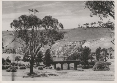
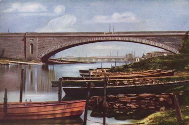
Photograph - Image, The First Prince's Bridge, Melbourne - Later Queen's Bridge, c1951
A colour image of the first Prince's Bridge built across the Yarra River in Melbourne. It was later known as Queen's Bridge.princes bridge, queen's bridge, yarra river, rowboats -
 Ballarat Tramway Museum
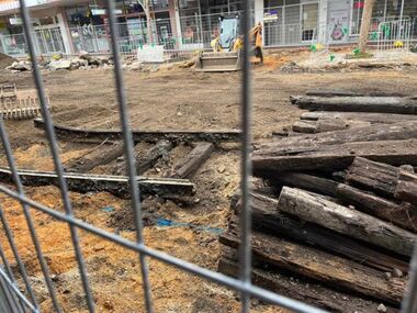
Photograph - Digital image, Paul McConville, Removal of Bridge St track, July 2023
Set of five digital images of the removal of track in Bridge St Ballarat as part of the redevelopment of the area and its reopening to motor car traffic July 2023. See also August 2023 issue of Fares Please! page 15 for other photos and page 4 for a short item. Photos by Paul McConville and Richard Gilbert.Yields information about the redevelopment of Bridge St Ballarat from a Mall back to an open road.Set of five digital images showing the removal of the track in Bridge St Ballarat.tramways, ballarat, bridge st, track removal -
 Phillip Island and District Historical Society Inc.
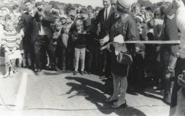
Photograph, Phillip Island Bridge Opening, 1969
Official Opening 1969 of 2nd Bridge connecting San Remo & Newhaven. Cutting the ribbon. From the Jack Jenner Collection.Cutting ribbon for Bridge Opening 1969 by Hon. Porter, Minister for Public Works & Mrs Porter. Taken from side. (2nd photo)local history, photographs, civil engineering, bridges, opening of phillip island bridge, black & white photograph, jack jenner collection, phillip island bridges, public construction -
 Kew Historical Society Inc
Work on paper, John Shirlow, View Across Princes Bridge, 1931
Original and framed etching of Princess Bridge Melbourne, created by John Shirlow in 1931.Framed black and white etching by John Shirlow of the view across Princes Bridge [Melbourne] looking north. The work is signed in pencil below the signed and dated etching.Artist's signature lower rightaustralian art, etchings, john shirlow, princes bridge - melbourne (vic) -
 Marysville & District Historical Society
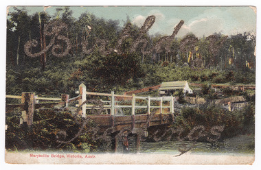
Postcard (item) - Colour tinted postcard, Nicholas John Caire, Marysville Bridge, Victoria, Austr, 1878-1904
One of a series of postcards of photographs taken by socialite photographer Nicholas John Caire.One of a series of postcards of photographs taken by socialite photographer Nicholas John Caire. N.J. Caire had a great love for the area in and surrounding Marysville and in the late 1800's took many photographs of Marysville and its surrounds. N.J. Caire was born in 1837 in Guernsey. He arrived in Adelaide about 1860 along with his parents who encouraged his early interest in photography. He opened a studio in Adelaide in 1867 after traveling extensively throughout the Gippsland taking photographs. After marrying in 1870 he moved to Talbot in Victoria until 1876 when he opened a studio in the Royal Arcade in Melbourne. After 1885 N.J. Caire gave up his city work and made his home in South Yarra and devoted the rest of his life to outdoor photography, specializing in the bush, the gullies and the mountains of south-eastern Victoria.Birthday/ Greetings POST CARD This Space may be Used/ for Correspondence The Address Only to be/ Written Here. 88421 Dear Ivy/ Wishing you/ many happy/ returns of/ the day/ from Reggie Miss Ivy Bastian/ Helston/ Fenwick Street/ Nth Carlton c1918 2nd Bridge The postage stamp has been removed. Helen Boach?marysville, victoria, nicholas john caire, bridge scene, 88421, postcard, souvenir -
 Greensborough Historical Society
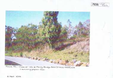
Photograph - Photograph (Copy), Anne Paul, Plenty Bridge Hotel site, 2003_03
21st century photograph of heritage site: former Plenty bridge Hotel and Tollhouse, situated on the eastern side of Old Lower Plenty Road, near the Old Lower Plenty Road Bridge on the east bank of the Plenty River. Although the Hotel burnt down, poplar trees still exist on the site.3 pages, 1 x colour photograph printed on paper, 1 x Heritage Inventory (text) and 1 historic black and white photo.On colour photograph: Close-up site of Plenty Bridge Hotel (H7922-0265) and surviving poplar tree. A. Paul 3/03plenty bridge hotel, lower plenty, plenty river -
 Phillip Island and District Historical Society Inc.
Photographs, Country Roads Board, Phillip Island 2nd Bridge Construction, 1966 - 1969
5 of a collection of 70 photographs taken during the construction and opening of the Phillip Island second bridge - by Country Roads Board and Shire of Bass. Contractor was John Holland & Co Pty Ltd.Five Black & White photographs taken in 1966-1969 of the construction of the Phillip Island second bridge between San Remo and Newhaven. 351-65, 351-66 & 351-69 show the bridge construction. 351-67 & 351-68 show the cutting of the ribbon at the opening and the crowd of people at the opening.351-65: CRG NEG No. 67-3821.phillip island 2nd bridge construction, phillip island bridge opening 1969, country roads board, john holland & co pty ltd, shire of bass, sasha stark -
 Ballarat Heritage Services
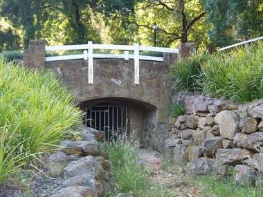
Photograph - Photograph - Colour, The Edna Walling Bridge at Locarno Spring in the Hepburn Springs Reserve, 2020, 12/12/2020
The Hepburn Springs Progress Association invited Edna Walling the the Hepburn Springs Reserve, and sandstone paths and bridges resulted. In 1934 there was a proposal to spend 2,000 to 3,000 poinds at the Hepburn Springs Reserve, with a govenrment loan suggested. Colour photograph of the stone bridge at Locarno Spring in the Hepburn Springs Reserve, with the new 'placed' rocks in the surrounds c2000hepburn springs, locarno, mineral water, hepburn springs reserve, locarno spring, edna walling -
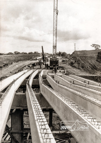
 Port of Echuca
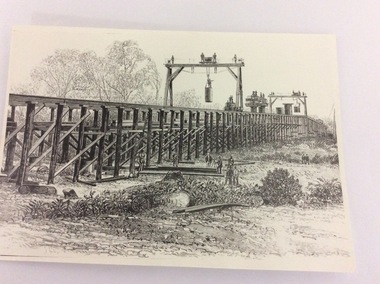
Photograph - Black and white photograph of a drawing, A black and white photograph of a drawing of the construction of the bridge crossing the Murray River at Echuca in 1887, 1981
The drawing shows all the activity and building roles involved in building a bridge in 1877. The crossing of the Murray River was very important to citizens living in both Echua, but especially those living in Moama and in further NSW regions as it provided them with access to Victorian market regions. The bridge was built privately for Deniliquin farmers, but eventually opened up to the general public.This is significant because it represents the roles of different tradesmen in the construction industry in the late 19th Century. It also shows construction stages . Bridge pylons are being inserted into the fiver banks. It is also a very well produced drawing, the artist is anonymous, but very skilled.A photograph of a drawing of the construction of the bridge crossing the Murray River in 1877. The picture shows surveyors, construction workers, crane operators, hoists and a crane and much activity.Written on the back in pen are the numbers 6530. In pencil are the numbers 61/8"? and 10"?. Stamped on the back is a small rectangle with the words 'COPYRIGHT. This photograph may not be reproduced without permission in writing from the Editot of "The Age" 250 Spencer Street Melbourne, and 39/41 York St., Sydney.' written inside it.bridge works, murray river crossing, moama, echuca, orm cook collection, 'the age' newspaper., deniliquin farmers, engineering, bridge building, pylons, 1877 -
 Melbourne Tram Museum
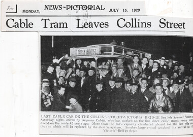
Newspaper, The Sun, The Herald, "Last cable car on the Collins Street - Victoria Bridge", 15/7/1929
Newspaper clipping from the Melbourne The Sun News Pictorial, 15/7/1929 about the closure of the Victoria Bridge line in Victoria St from Brunswick St. Has a photo of the event at the Collins St, Driven by Gripman Cubitt. Second copy is photo printed on heavy paperYields information about the last Victoria St cable tram.Newspaper Clipping - on newsprint or heavy paper. The timeline gives the date of closure of the Brunswick St to Victoria Bridge line as Saturday 13 July 1929. Titled "Last cable car on the Collins Street - Victoria Bridge" Checked for The Argus in Trove - not shown on line.trams, tramways, conversion, victoria bridge, closure, collins st, cable trams, victoria st -
 Charlton Golden Grains Museum Inc
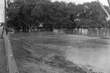
Photograph, Cameron, Ian, 1973 flooded Avoca River, Feb 19873
1973 flooded Avoca River. Viewed from west side of Paterson Bridge behind the shire office.B/W photograph of 1973 flooded Avoca River. View West side of Paterson Bridge behind Shire Officeflood, avoca river, charlton -
Ringwood and District Historical Society
Letter, Personal correspondence - 1985 - including reference to purchase of Burnt Bridge Store by parents of Clarice de Pelsenaire in 1923 and brief history and death of Ringwood East resident, Arthur Meyland (1911-1985)
Incomplete letter from Clarice dePelsenaide, whose parents purchased the Burnt Bridge Store from Mr Williams. Her husband Arthur was the first pupil enrolled at the Ringwood East Primary School.2 pages hand written letter about early East Ringwood and Burnt Bridge Store. +Additional Keywords: dePelsenaide, Clarice -
 Lakes Entrance Historical Society
Photograph, North Arm bridge Lakes Entrance Victoria c1900, 1900c
Jemmies Point BridgeBlack and white photograph of the wooden bridge across the North Arm, showing the original width of the North Arm, the start of the road up to Kalimna bordered by a post and rail fence, the heights of Kalimna concealed by dense vegetation. Lakes Entrance Victoriabridges, vegetation, fences -
 Emerald Museum & Nobelius Heritage Park
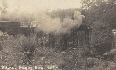
Photograph, Postcard, Belgrave Train on Trestle Bridge, 13/01/1914
Early postcard of Puffing Billy on trestle bridge Faded sepia photograph/postcard depicting Puffing Billy on Trestle BridgeFront: text, Belgrave Train on 'Tressel' Bridge Back: Handwritten text: 13/01/1914? Emerald - Dear Mother we are at Emerald, on our way to L. Pa? Everything is going well. Crarj/ys? are going Dande (Dandenong?) Father slept all night. Will write in a couple of days. Jesse's in good form stocking up provisions. No need to worry, Loving son Blair ?puffing billy, belgrave, whiteside -
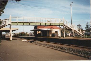 Sunbury Family History and Heritage Society Inc.
Photograph, Elwyn Davis, Pedestrian Bridge, C1990s
The wooden pedestrian bridge spanned the rail tracks at Sunbury Railway Station and were replaced with a more modern bridge and ramp when upgrades were done at the station and along the Bendigo line in the late 1990s and early 2000s. The water tank beyond the station building was used to refill the engines with water when steam engines were used. Diesel driven V Line trains now convey commuters from the regional towns along the Bendigo region to Melbourne.The Bendigo Line was the first government rail line to open and it reached Sunbury in 1859. It was extended to Bendigo and opened in 1861.A non-digital coloured photograph of a wooden pedestrian bridge spanning rail tracks with a wooden station building and former water tower on the station platform. rail bridges, bendigo rail line, sunbury station, water towers, railways -
 Eltham District Historical Society Inc
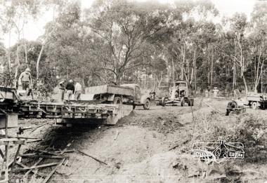
Photograph, Construction of Lower Plenty Bridge, Main Road, c.August 1966, 1966
This black and white photograph records construction activity of the then new Main Road bridge over the Plenty River at Lower Plenty in 1969.Local significanceBlack and white photograph taken during construction of the Main Road bridge over the Plenty River. Includes structural members, construction personnel, vehicles and a Clarke mobile crane.mobile cranes, bridge construction, main road, plenty river, lower plenty, bridges