Showing 536 items matching "minerals"
-
 Eltham District Historical Society Inc
Document - Folder, Ray, Grant
Ray Grant, living in Eltham, won world mineral water drinking championships. Contents Newspaper article: "Water's nectar to Grant", Diamond Valley News, 1 March 2006. Justin Purser's works to be displayed at the Melbourne International Flower and Garden Show.Newspaper clippings, A4 photocopies, etcray grant, world championship mineral water drinking -
 City of Moorabbin Historical Society (Operating the Box Cottage Museum)
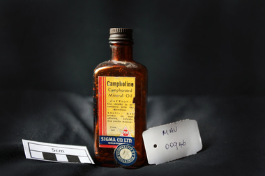
Manufactured Glass, brown bottle 'Campholine', c1950
Sigma was founded by two Melbourne pharmacists in 1912, it has grown to become one of the key players in Australia’s pharmacy industry .Edwin Thomas Church (1864 – 1947) and Ernest Holloway Leete a prominent chemist and a member of the College of Pharmacy who had established his own pharmacy in 1897. The entrepreneurial Leete had been part of a move in 1904 among a group of commercially-minded chemists to put up proprietary preparations. 1913 - 1927 Initially, the fortunes of the Sigma enterprise relied on E. H. Leete ‘working from home’, and even as late as 1915 company address was in Claremont Avenue Malvern. Following the establishment of the business in 1912, the Sigma Company Limited was located at Flinders Lane, Melbourne. Sigma – Tromax, 1928 E.H. Leete after sixteen years, said he would not stand again as a director of the company because interests were also turning elsewhere. He was assisting another company as its agent in the motor trade. 1938 to1953 was characterised by steady growth for Sigma, accelerated by manufacturing opportunities during World War Two. Between 1975 and 1996 the company was transformed as it entered a period of both consolidation and rapid growth. The appointment, in 1996, of new Managing Director, George Savvides, marked a break from the past. Today Sigma is a leading full line wholesale and distribution business to pharmacy. Sigma is also the owner of some of Australia’s best known pharmacy brands in Amcal, Guardian and Amcal MaxA triangular shaped, brown glass, bottle with a metal screw top containing ‘Campholine’Front label : Campholine / Camphorated / Mineral Oil / CAUTION ! / Use strictly in accordance / with the directions / Adults : Rub briskly on parts affected . Infants ; Use gentle massage . / 20z. / TROMAX / SIGMA CO. Ltd. / MELBOURNE / Label Sticker : ROBERTSON OF ELSTERNWICK 1/ 8 pharmacy, medicines, campholine, glassware, bottles, moorabbin, bentleigh, cheltenham, melbourne, tromax-sigma co ltd, leete ernest, church edwin, sigma company pty ltd -
 Federation University Historical Collection
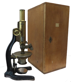
Instrument - Scientific Instrument, Boxed Petrographic Microscope, c1912
Used at the Ballarat School of Mines Petrology classes. Probably a second generation petrological microscope used at SMB. Earlier reference ; to " Petrological Microscope" is made in SMB 1908 - 9 calendar page 35. Reference to "Mineral Microscopy" found in calendar for 1896, page 47. Petrographic Microscope with two-lens objective turret in a timber case. The microscope black enameled frame with brass components. Housed in a polished wood case. Three additional polarizing filters in accessory drawer. "E. Leitz Wetzlar No. 139041 Made for Kilpatrick & Co Melbourne" A removable label inside storage case door, dated "I.II.1912" and stating the obtainable magnification ratios.ballarat school of mines, geology, petrography, microscope, scientific objects, scientific instruments -
 Federation University Historical Collection
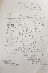
Letter, Henry Harvey of Hokitika New Zealand to Ballarat School of Mines, 1884, 1884
... minerals ...Letter regarding analysis of material.henry harvey, hokitika, new zealand, ballarat school of mines, minerals, analysis, mining -
Bendigo Historical Society Inc.
Letter - KANGAROO FLAT GOLD MINE COLLECTION: ARVI PARBO, WESTERN MINING CORPORATION
Letter addressed to Sir Arvi Parbo, Western Mining Corporation, Melbourne, from J.M. Lalor, Exploration Manager, Minerals WMC, regarding support sought by the Bendigo Trust to develop an underground tourist mine at Bendigo. J.H Lalor seeks the support of Western Mining,'either by contgributing money or equipment' to develop the Central Deborah Gold mine as a tourist destination.bendigo, gold mining, central deborah gold mine, bendigo, gold mining, tourism, central deborah gold mine, de-watering, western mining corporation., sir arvi parbo, j.m. lalor, daryl mcclure, bendigo trust -
 Bendigo Historical Society Inc.
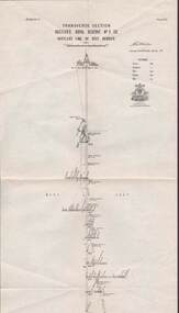
Map - STRUGNELL COLLECTION: HUSTLER'S LINE OF REEF, BENDIGO, September 1913
Map, Hustler's Line of Reef, Hustler's Royal Reserve No. 2 Co, Bendigo,Transverse Section, Plate No.V11 (7). Bulletin No 33 Signed H.A.Whitelaw Underground survey Office Bendigo September 1913 Drawing shows mine shaft to over 1640 feet deep and appears to show samples of connecting horizontal shafts with their respective mineral contentsUnderground Survey Office, Bendigo.map, bendigo, hustler's royal reserve no. 2 mine* -
 Orbost & District Historical Society
fossil
Found at Point Hicks. Probably part of the root of the tree. This is a type of petrified wood that has had all of the wood cells replaced with calcite mineral. After exposure to the ultraviolet light of the sun for a few years, the petrified wood has turned dark. Inspected by George Rawlings 6.2.2013.One piece of fossil of a calcified tea tree.fossil tea-tree petrified-wood calcification -
 Federation University Historical Collection
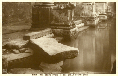
Postcard - Sepia, The Diving Stone in the Great Roman Bath, Bath, Somerset
The Great Bath is a massive pool, lined with 45 sheets of lead, and filled with hot spa water. It once stood in an enormous barrel-vaulted hall that rose to a height of 40 metres. For many Roman visitors this may have been the largest building they had ever entered in their life. The bath is 1.6 metres deep, which was ideal for bathing, and it has steps leading down on all sides. Niches around the baths would have held benches for bathers and possibly small tables for drinks or snacks. A large flat slab of stone is set across the point where hot water flows into the bath. It is known today as the diving stone. The Roman Baths complex is a site of historical interest in the English city of Bath. The house is a well-preserved Roman site for public bathing. The Roman Baths themselves are below the modern street level. There are four main features: the Sacred Spring, the Roman Temple, the Roman Bath House and the Museum, holding finds from Roman Bath. The buildings above street level date from the 19th century. Sepia postcard of a section of the Great Roman Bath at Bath, Somerset featuring the Diving Stone.printed verso: The Diving Stone in the great roman bath. The Diving stone, at the north-west corner of the great Roman Bath, still shows where the feet of bygone bathers wore away its surface. The hot mineral waters flowed into the bath through a channel under this stone. chatham-holmes family collection, bath, great roman bath, swimming pool -
 Kiewa Valley Historical Society
Report - Alpine Study Area Volume 2 Maps, Land Conservation Council, 1970s
The Victorian Environmental Assessment Council and the former Environment Conservation Council (ECC) and Land Conservation Council (LCC) have completed 36 land use investigations over more than 35 years, including 27 regional reviews. They provide a framework for use of Public Land in Victoria. The Land Conservation Council was established by the Land Conservation Act 1970.These maps provide an assessment of the Alpine area at the time the maps were created. Some of the topics eg. Rainfall and water resources may change over the years thus providing a comparative analysis. Others may provide information for future development such as mineral exploration, building of a dam / tunnel etc.Blue box shaped folder containing 9 of 10 Maps of the Alpine Study Area produced by the Land Conservation Council. Maps include 1. Public land and descriptive blocks. 2. Physiography. 3. Topography. 4. Geology (missing). 5. Rainfall and water resources. 6. Vegetation 7. Land systems. 8. Recreation. 9. Primary production. 10. Minerals Ex library item. Stamped in red "Discarded From Stock / Swan Hill Regional Libraryalpine area, maps of alpine area, land conservation council -
 Bendigo Historical Society Inc.
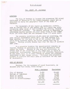
Document - BENDIGO - THE HEART OF VICTORIA
Typed article titled Bendigo, The Heart of Victoria. Items mentioned are Location, Area of Bendigo, The People, Work Force, Industrial Base, natural Resources, Agriculture and Livestock, Minerals, Forests, Rail and Road, Sea and Air, Power and Water, Electricity, Natural Gas, Water, Sewerage, Industrial Land, Services, Community Services and Facilities, Educational Facilities, Hospitals, Culture and Tourism and Media.document, bendigo - the heart of victoria, city of bendigo, borough of eaglehawk, shire of huntly, shire of marong, shire of strathfieldsaye, bendigo development committee, department of agriculture, department of state development decentralization and tourism, state electricity commission, gas & fuel corporation of victoria, state rivers & water supply commission, bendigo sewerage authority, the bendigo college of advanced education, home and hospital for the aged, home for the blind, northern school of nursing, art gallery, historical society, dudley house, sun loong, central deborah gold mine, the vintage talking trams and transport museum, bcv8, the bendigo advertiser, golden city gazette, 3bo, 3cv, mr a j kelly -
 Kew Historical Society Inc
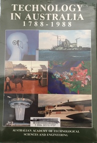
Book - Brown Gouge clothes brush, Australian Academy of Technological Sciences and Engineering, Technology in Australia, 1788-1988 : A condensed history of Australian technological innovation and adaptation during the first two hundred years, 1988
This book provides a history of technology in Australia from 1788 to 1988. There are twelve chapters by different authors. These chapters are: Innovation, science and the farmer (D.E. Tribe and L.J. Peel) Food technology (K.T.H. Farrer) Water and irrigation (K.D. Green) Forestry and forest products (W.H. Algar) Australian innovation in textile technology (D.S. Taylor) Engineering construction and building (J. Holland) Transport (B. Inglis) Communications and computers (J.H. Curtis and T. Pearcey) The chemical industry and Australian contributions to chemical technology (J.E. Kolm) The mineral industries (G.B. O'Malley) Energy (R.N. Morse) Manufacturing industry (P.N. Richards) Defence science and technology (J.L. Farrands and J.C. Wisdom) Index, photographs.Melbourne : Australian Academy of Technological Sciences and Engineering, c1988 xxix, 1017 p. : ill., maps, ports., plans, facsims. ; 26 cm. non-fictionThis book provides a history of technology in Australia from 1788 to 1988. There are twelve chapters by different authors. These chapters are: Innovation, science and the farmer (D.E. Tribe and L.J. Peel) Food technology (K.T.H. Farrer) Water and irrigation (K.D. Green) Forestry and forest products (W.H. Algar) Australian innovation in textile technology (D.S. Taylor) Engineering construction and building (J. Holland) Transport (B. Inglis) Communications and computers (J.H. Curtis and T. Pearcey) The chemical industry and Australian contributions to chemical technology (J.E. Kolm) The mineral industries (G.B. O'Malley) Energy (R.N. Morse) Manufacturing industry (P.N. Richards) Defence science and technology (J.L. Farrands and J.C. Wisdom) Index, photographs.technology -- australia -- history., technological innovations -- australia -- history. -
 The Beechworth Burke Museum
Geological specimen - Yellow Sandstone
This specimen is from Barefoot Hills, Victoria. Sandstones are economically important as major reservoirs for both petroleum and water, as building materials, and as valuable sources of metallic ores. Most significantly, they are the single most useful sedimentary rock type for deciphering Earth history. This specimen is part of a larger collection of geological and mineral specimens collected from around Australia (and some parts of the world) and donated to the Burke Museum between 1868-1880. A large percentage of these specimens were collected in Victoria as part of the Geological Survey of Victoria that begun in 1852 (in response to the Gold Rush) to study and map the geology of Victoria. Collecting geological specimens was an important part of mapping and understanding the scientific makeup of the earth. Many of these specimens were sent to research and collecting organisations across Australia, including the Burke Museum, to educate and encourage further study.A sedimentary rock composed mostly of quartz sand. Sandstone is the second most common sedimentary rock after shale. Sandstones consist of sand-sized grains principally quartz, feldspar and rock fragments. The two major classes of sandstone are arenite and wacke. the colour of sandstone varies from grey, yellow, red and white reflecting the variation in mineral content and cement and is gritty to touch (like sandpaper).Geological survey / R.... S 61 / Loc Bareboot Hills / Sheet / 24SE / 94 /burke museum, beechworth, indigo shire, beechworth museum, geological, geological specimen, mineralogy, sandstone, yellow sandstone, victoria, barefoot hills -
 Bendigo Historical Society Inc.
Photograph - WALLIS & WALLACE - AUCTIONEER. BENDIGO
Photograph - black and white. ALF. E. WALLIS & WALLACE. Land Salesman. Grain Merchants. Commission Agents. Auctioneer. 'In Bull Street between Pall Mall and Hargreaves Street, near where Bendigo Building Society was'. Photo is of a beautiful building with 5 men standing out the front. In the middle of the two doors a sign 'Hepburn Mineral Springs - COY - (Daylesford). H.Ross, Manager. Telephone 3121.place, building, wallis & wallace, wallis & wallace, auctioneer. bull street, bendigo. -
 Bendigo Historical Society Inc.
Newspaper - LYDIA CHANCELLOR COLLECTION: REDVERS EDDY OBITUARY
Newspaper clipping (Bendigo Advertiser, 5th August 1968) on backing cardboard, telling story of Redvers James Eddy, an expert of wildlife and minerals. Redvers lived near the Spring Gully Reservoir and taught chemistry at the School of Mines, Bendigo. One of his 'better known works is a record of bird sounds, calls and songs'. Also attached alongside the article are his death and funeral notice.person, bendigo, redvers james eddy -
 City of Moorabbin Historical Society (Operating the Box Cottage Museum)
Tools, Spanner Auto x4 'Vana Dium', 20thC
4x steel Automobile Spanners ' Vana Dium' used by a resident of the City of Moorabbin c1950 Vanadium is a hard, silver-grey metallic element. It is a ductile transition metal with a natural resistance to corrosion and stability against alkalis, acids and salt water. Vanadium is found in over 60 different minerals including vanadinite, carnotite, roscoelite and patronite.This Vana Dium Spanner set is typical of the type used by car mechanics in the City of Moorabbin c1950Set of 4 graduated automobile steel spanners made by Vana Dium Ltd USA c 1950 Front Forged VANA DIUM Steel 3/4 Pat.Pend. Back AUTO-KIT No.100 Made in USAspanners, automobiles, car mechanics, vana dium ltd usa, vanadium, uranium, early settlers, market gardeners, blacksmiths, tools, building equipment, hammers, moorabbin shire, bentleigh, mckinnon, highett, cheltenham,mcewan james pty ltd, melbourne, bunnings pty ltd, -
 Bendigo Historical Society Inc.
Tool - Small gold puddling Cradle
A wooden miner's cradle with metal sieve used to separate gold or other heavy minerals from soil and water. Washdirt and water were tipped into the sieve at the top while the cradle was rocked. The oscillating motion washed away sand and fine particles, leaving the gold trapped behind ridges across the bottom. Large rocks and gravel caught by the sieve were discarded by hand. The metal sieve is slightly damaged.gold minning, gold washing cradle -
 The Beechworth Burke Museum
Geological specimen - Hyalite in Basalt
According to the 1912 Department of Mines Bulletin of the Geological Survey of Victoria, basalt covers a considerable portion of the Macedon area including Mount Macedon. Basalt is the most common form of rock underlying the earth's surface and is found in three kinds of rock forming environments: ocean divergent boundaries, oceanic hotspots, and mantle plumes and hotspots beneath continents.This specimen is part of a larger collection of geological and mineral specimens collected from around Australia (and some parts of the world) and donated to the Burke Museum between 1868-1880. A large percentage of these specimens were collected in Victoria as part of the Geological Survey of Victoria that begun in 1852 (in response to the Gold Rush) to study and map the geology of Victoria. Collecting geological specimens was an important part of mapping and understanding the scientific makeup of the earth. Many of these specimens were sent to research and collecting organisations across Australia, including the Burke Museum, to educate and encourage further study.A solid mass, geological specimen in shades of grey and white. Hyalite is a colourless variety of opal. It occurs as globular and botryoidal masses and irregular crusts in volcanic and pegmatite environments where the silica deposits from the gas phase. Basalt is dark in colour, fine-grained igneous rock composed of plagioclase and pyroxene minerals. It is commonly formed as an extrusive rock, such as lava flow. It is one of the most common forms of rock underlying the earth's surface.burke museum, geological specimen, department of mines, geological survey of victoria, basalt, mount macedon, beechworth -
 Bendigo Historical Society Inc.
Document - MINING REPORTS - ANNUAL REPORT, INCLUDING GOLD & MINERAL STATISTICS 1936
Handwritten notes from the Annual Report, including Gold & Mineral Statistics, 1936. Mentioned are the London price of gold and the equivalent local price, No of batteries, Abandoned Mining Shafts, Cost of making the shafts safe, Inspection of boilers and the no condemned, No of First and Second Class e 'driver Certificates issued for 1935 and 1936, Alluvial and quartz gold yields for the Bendigo District, men employed in mining, Accidents and development at the Central Nell Gwynne.document, gold, mining reports, annual report including gold & mineral statistics 1936, state batteries, central nell gwynne -
 Stawell Historical Society Inc
Photograph, Beginning of Decline made by Stawell Joint Venture Mining Stawell 1981
Beginning of Decline made by Stawell Joint Venture Mining Stawell 1981. Stawell Joint Venture. The Magdala gold mine was officially opened by -Hon David White M.L.C. Minister for Minerals and Energy on Friday 5th Oct. 1984. Gold production 1984. Gold by July 1991 approximately 142,500 ounces. Length of decline 4 Km's. Approx. length of development 18 Km's.Black and white photograph of a long trench with fence either side of the trench. Buildings in the background behind bush setting.stawell -
 The Beechworth Burke Museum
Geological specimen - Dolomite
Dolomite is a mineral, calcium magnesium carbonate, with the chemical formula CaMg(CO3)2. It is a principle component of various rock types sometimes also referred to as dolomite, including dolostone, dolomitic marble and dolomitic limestone (according to the composition of each type). Dolomite rock is found in sedimentary basins throughout the world, comprising approximately 2% of the Earth's crust. It is formed when lime mud or limestone encounters groundwater containing magnesium. Dolomite can contain elements such as lead, zinc and copper. Dolomite and limestone are used in various construction, landscaping and agricultural processes. This specimen was donated to the Burke Museum in 1868 by Alfred Selwyn as part of the Geological Survey of Victoria. It was donated to the Museum in 1868. Victoria and other regions of Australia were surveyed for sites of potential mineral wealth throughout the 19th Century. The identification of sites containing valuable commodities such as gold, iron ore and gemstones in a locality had the potential to shape the development and history of communities and industries in the area. The discovery of gold in Victoria, for instance, had a significant influence on the development of the area now known as 'the goldfields', including Beechworth; the city of Melbourne and Victoria as a whole. Dolomite and limestone are mined at several locations in Victoria, including sites in the North-East of the state in Bindi and Limestone Creek. There are notable dolomite deposits in most Australian states. The dolomitised form of the mineral tends to come from older limestone deposits, formed during the palaeozoic era in marine settings, so this specimen may have come from a deposit located along a coastline in Victoria or another state. The specimen is significant as an example of surveying activity undertaken to assess and direct the development of the mineral resource industries in Victoria and Australia, as well as the movement to expand human knowledge of earth sciences such as mineralogy and geology in the nineteenth century. This specimen is part of a larger collection of geological and mineral specimens collected from around Australia (and some parts of the world) and donated to the Burke Museum between 1868-1880. A large percentage of these specimens were collected in Victoria as part of the Geological Survey of Victoria that begun in 1852 (in response to the Gold Rush) to study and map the geology of Victoria. Collecting geological specimens was an important part of mapping and understanding the scientific makeup of the earth. Many of these specimens were sent to research and collecting organisations across Australia, including the Burke Museum, to educate and encourage further study.Hand-sized piece of pale pink dolomite (calcium magnesium carbonate) with dark grey rim and hollowed centre. geological specimen, geology, geology collection, burke museum, beechworth, dolomite, mineralogy, geological survey, alfred selwyn, limestone, calcium magnesium carbonate -
![View of the Township of Ballan / [by] Nicholas Caire, circa 1876](/media/collectors/550653872162f11fb04854aa/items/578258d3d0cdd1176ce23812/item-media/57825939d0cdd1176ce27694/item-fit-380x285.jpg) Kew Historical Society Inc
Kew Historical Society IncPhotograph, Anglo-Australasian Photographic Company, View of the Township of Ballan, c. 1876
Nicholas Caire was born on Guernsey in the Channel Islands in 1837. He arrived in Adelaide with his parents in about 1860. In 1867, following photographic journeys in Gippsland, he opened a studio in Adelaide. From 1870 to 1876 he lived and worked in Talbot in Central Victoria. In 1876 he purchased T. F. Chuck's studios in the Royal Arcade Melbourne. In 1885, following the introduction of dry plate photography, he began a series of landscape series, which were commercially successful. As a photographer, he travelled extensively through Victoria, photographing places few of his contemporaries had previously seen. He died in 1918. Reference: Jack Cato, 'Caire, Nicholas John (1837–1918)', Australian Dictionary of Biography.An original, rare photograph from the series 'Views of Victoria: General Series' by the photographer, Nicholas Caire (1837-1918). The series of 60 photographs that comprise the series was issued c. 1876 and reinforced a neo-Romantic view of the Australian landscape to which a growing nationalist movement would respond. Nicholas Caire was active as a photographer in Australia from 1858 until his death in 1918. His vision of the Australian bush and pioneer life had a counterpart in the works of Henry Lawson and other nationalist poets, authors and painters.‘View of the Township of Ballan’.; Views of Victoria (General Series) No.35; Albumen silver photograph | Photo on card with Title and Description on reverse | Mounted 24 x 30 cm; Photo 12 x 17 cm.On Reverse: ‘The Township of Ballan is situated near the Bullarook Forest, and is distant about twenty miles from Ballarat. It is chiefly a small agricultural town, but it has become notable of late owing to its Mineral Springs, of which there are several in the neighbourhood. The most important one is owned by Messrs. Joske & Co., who supply the public with this delightful beverage.’ nicholas caire (1837-1918), ballan, bullarook forest, mineral water, ballan mineral springs, post and rail fence -
 Bendigo Historical Society Inc.
Map - STRUGNELL COLLECTION: UNDERGROUND SURVEY OF MINES, BENDIGO DISTRICT, 7-1-99
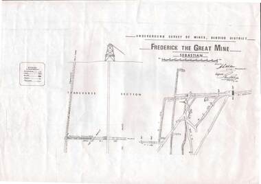
Map, Underground Survey of Mines Bendigo District.Frederick the Great Mine, Sebastian. A collection of nine (9) maps of the mine, Signed H.S.Whitelaw Field Geologist 4.1.99 with some notes relating to same, including a: * Typed overview of the operation of the mine in 1912. * Clipping from Victoria its Mines and Minerals detailing the operation of the mine from its beginning in 1863 where it was first worked for alluvial. Charlton & Co., and Mr. Glass mentioned in article.A.S.Whitelawmap, bendigo, frederick the great mine -
 Kiewa Valley Historical Society
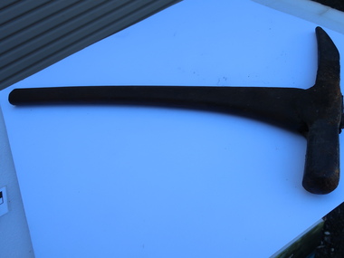
Miners Pick - short
Formerly KV 071. It was used to break up rock and ore, making it easier to extract valuable minerals. The pointed end of the pick axe was used to chip away rock, while the flat end was used to strike the rock for breaking it apart. This one has a short handle. Miners picks were commonly used in the the 19th and early 20th centuries for extracting gold from underground mine tunnels.Used in the Kiewa Valley where prospecting for gold occurred.Formerly KV 071. Cast iron symmetrical pick tool on cast iron with a wooden handle. It has a pointed end and a flat end. It is 12 inches long.gold mining, miners' pick axe, hand tool -
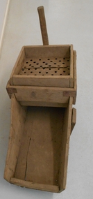
Clunes Museum
Tool - GOLD CRADLE & PANNING DISH, JAMES ESMOND, CIRCA 1850
USED TO OBTAIN ALLUVIAL GOLD THE DESIGN OF THIS EQUIPMENT IS MOSTLY BASED ON THE PRINCIPLE OF THE WAY HEAVY MINERALS ARE CONCENTRATED IN ALLUVIAL DEPOSITS. THE PROSPECTING DISH IS USED WHEN WORKING WITH SMALL AMOUNTS OF STONES & CLAY WHILE BIGGER JOBS THE CRADLE OR BANJO IS MORE EFFICIENT. THE GAUZE OF MESH IN THE SIEVE IS VARIABLE. THE CRADLE OR BANJO IS USUALLY SET UP AT RIGHT ANGLES TO A SHALLOW CREEK OR WATERHOLE WITH THE OPEN ENDS TOWARDS THE WATER.1 WOODEN CONSTRUCTION MADE BY HAND WITH GAUZE FILTER IN UPPER SECTION TO SEPARATE QUARTZ ROCKS, SAND AND SOIL. A HANDLE ON BOX LIKE CONSTRUCTION IS USED TO ROCK THE CRADLE WHICH IS MOUNTED WITH ITS ROCKERS RESTING ON WOODEN BEARERS. .2 PANlocal history, mining equipment, mining -
 Bendigo Historical Society Inc.
Document - VICTORIA HILL - THE BENDIGO DIGGINGS, PRELIMINARY DRAFT FOR BROCHURE
BHS CollectionNine typed pages of notes on a preliminary draft for a brochure on the Bendigo Diggings. First part is the objective which is to preserve the mining history and to have exhibits in the places they were used, e.g. quartz mining machinery exhibited in a quartz mining area, not on an alluvial field. Part B is historical notes on the area. Part C is the Site - Victoria Hill area. Part D is Stage One which consists of carpark area, technological museum, restaurant, mineral haulage line, picnic ground, earthworks and planting over the area. Part E is Stage Two which will consist of the open-air exhibits, in the area surrounded by the mineral haulage line, and the Central Nell Gwynne mine on the west side of the site. Part F is Stage Three which will consist of the winery, the steam tram track, the lake, the wildlife sanctuary and various buildings associated with gold mining. Part G is Costing with the prices to be filled in. Parts H and I are the Appeal and the Committee. Details to be filled in. Notes prepared by Albert Richardson.mining, marketing, victoria hill, victoria hill, the bendigo diggings - preliminary draft for brochure, aust national travel association, tullamarine jetport, emu bottom homestead, kyneton historical museum, chinese joss house, eaglehawk museum, whipstick scrub, cairn curran reservoir, castelmaine historical museum and market hall, national trust, ballarat hiatorical park, echuca's hopwood gardens, swan hill folk museum, gibson's mount alexander no 2 squatting run, captain brown, chief commissioner wright, hustler's reef, thomas hustler, mining board, drainage of reefs act 1862, first world war, bendigo amalgamated goldfields, second world war, sandhurst, w c vahland, battery trams, horse trams, steam trams, electric trams, central nell gwynne mine, theodore ballerstadt, george lansell, new chum hill, ballerstadt's open cut, 180 mine, new chum syncline battery, william rae, victoria quartz, wittscheibe's 'jeweller's shop', luffsman and sterry, gold mines hotel, adventure, bendigo and district tourist association, bendigo city council, bendigo branch of the royal historical society of victoria, professor brian lewis, school of architecture and building at the university of melbourne, taylor horsfield, lord robert cecil, south australian gold commissioner -
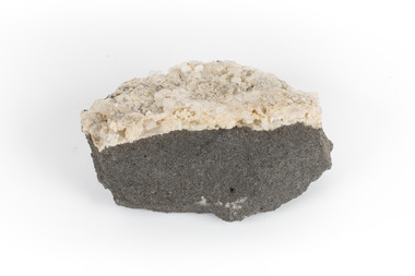
 The Beechworth Burke Museum
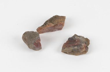
Geological specimen - Unknown, possible Carnelian Agate or Chalcedony
Although it is not known where these specimens were collected, Victoria and other regions of Australia were surveyed for sites of potential mineral wealth throughout the 19th Century. The identification of sites containing valuable commodities such as gold, iron ore and gemstones in a locality had the potential to shape the development and history of communities and industries in the area. The discovery of gold in Victoria, for instance, had a significant influence on the development of the area now known as 'the goldfields', including Beechworth; the city of Melbourne and Victoria as a whole. Agate occurs when amygdales (gas pockets) form in the upper levels of basaltic lava flows. If these pockets or bubbles are iniltrated by water bearing silica in solution, the fluid dries and hardens in layers, forming round or egg shaped nodules or geodes within the rocky matrix. Agate is formed of a silica mineral chalcedony similar to quartz. The term carnelian primarily refers to the reddish shading of the stone; whether the stone is termed an agate or chalcedony type is often influenced by the degree of colour banding the specimen shows. The specimens are significant as examples of surveying activity undertaken to assess and direct the development of the mineral resource industries in Victoria and Australia, as well as the movement to expand human knowledge of earth sciences such as mineralogy and geology in the nineteenth century.Three small geological specimens that appear visually consistent with images of rough or unpolished Carnelian Agate or Chalcedony. geological specimen, geology, geology collection, burke museum, beechworth, indigo shire, north-east victoria, gemstones, agate, carnelian -
Federation University Historical Collection
Letter, Australian Natives' Association Correspondence to Ballarat School of Mines, 04/02/1958 and 05/02/1958
The Australian Natives Association was founded in 1871, and key members included Alfred Deakin. The Ballarat branch was at 22 Camp Street. The Ballarat School of Mines was formed in 1870, and gradually developed to become an education facility. This correspondence dates from the 4th and 5th February 1958, and concerns a Branch Address on the 10th of February about the "Functions of the Mines Department and Mineral Resources in Victoria", to which School of Mines teachers and students were invited.Two typewritten letters between the Australian Natives' Association (A.N.A) and Ballarat School of Mines. Includes notes from secretary and A.N.A Letterhead.Letterhead - "This Flag represents Your Country: Support it." letterhead, australian natives association, school of mines, ana, deakin, alfred deakin, camp street, ballarat, ballarat school of mines principal, r. w. richards, s. a. c. williams, secretary, lydiard street south, w. g. foley, invitation, speech, address, dick richards, richard w. richards, australian natives' assoication, ana branch 4 ballarat -
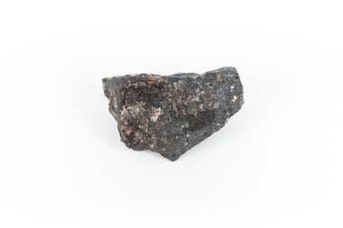 The Beechworth Burke Museum
Geological specimen - Ilvaite
Ilvaite has acquired its name from Ilva (Latin for Elba) Island, Greece, where Ilvaite is most commonly found. The geological setting in which Ilvaite occurs is through contact with magnetite, zinc and copper ore deposits, along with contact metamorphic deposits and zeolite zones. llvaite crystallizes in the form of black prismatic crystals and columns . This specimen was retrieved from Broken hill, known as the world's richest and largest zinc-lead ore deposit. Because of Ilvaite's often unaesthetic crystal formations compared to other minerals, Ilvaite is uncommon in most rock collections, particularly specimens that are not well formed, such as this one. Ilvaite is also a member of the Sorosilicate subclass of the silicate minerals, which have an unusual basic unit of Si2O7, making Ilvaite a unique mineral. Given that Ilvaite is not commonly found in Australia, it marks a unique contribution to an Australian collection of minerals. This specimen is part of a larger collection of geological and mineral specimens collected from around Australia (and some parts of the world) and donated to the Burke Museum between 1868-1880. A large percentage of these specimens were collected in Victoria as part of the Geological Survey of Victoria that begun in 1852 (in response to the Gold Rush) to study and map the geology of Victoria. Collecting geological specimens was an important part of mapping and understanding the scientific makeup of the earth. Many of these specimens were sent to research and collecting organisations across Australia, including the Burke Museum, to educate and encourage further study.A solid hand-sized ferrous iron analogue mineral with of black with shades of beige Ilvaite is a brittle, opaque rock formation that has acquired its name from Ilva (Latin for Elba) Island, Greece, where Ilvaite is most commonly found. The geological setting in which Ilvaite occurs is through contact with magnetite, zinc and copper ore deposits, along with contact metamorphic deposits and zeolite zones. llvaite crystallizes in the form of black prismatic crystals and columns rock, mineral, ilvaite, ilvaite specimen -
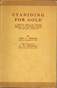 Federation University Historical Collection
Book, Cyaniding for Gold, 1939, 1939
500 of these books were printed, and many were used in the field, making good copies very rare. A simple but detailed account of the process written especially for the working miner and the small syndicate, the Quintessential Australian gold Mining book.Orange, hard, cloth covered b270 page book with brown dust jacket. Chapters include sampling sand and slime dumps; treating sand; aeration; treatment of slime; smelting; solution testing; cyanide solution; air- slaked lime; cyanding in Queensland; copper troubles; treatment of concentrates; amalgamations; assaying; floatation; chemistry; testing for minerals. Includes photographic reproductions of a cyanide plant for sand; aeration tower; mixer tank; Eleanora cyaniding plant; mining, gold, cyanide, cyaniding, leaching, smelting, slimes -
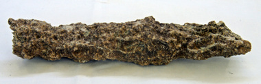
 The Beechworth Burke Museum
Geological specimen - Basalt (igneous-volcanic) containing Olivine, unknown
This particular geological specimen was found in Mount Franklin or Lalgambook in Djadjawurrung, located between Daylesford and Newstead, approximately ninety minutes drive from Melbourne. The mountain is an example of a breached scoria cone (a steep conical hill of loose pyroclastic fragments) which was created by a volcanic eruption about 470,000 years ago, a date which may indicate the age of this geological specimen. The volcanic eruptions of Mount Franklin were most likely witnessed by members of the Dja Dja Wurrung Aboriginal tribe, who referred to this country as the 'smoking grounds'. Mount Franklin and the surrounding area appears to have been a place of considerable religious significance to Aboriginal people, there is evidence which indicates that frequent large ceremonial gatherings took place in the area. Basalt is the most common rock on Earth’s surface, more than 90% of all volcanic rock on Earth is basalt. Basalt is an aphanitic extrusive igneous rock formed from the rapid cooling of low-viscosity lava exposed at or very near the surface of a rocky planet or moon. Specimens are black in colour and weather to dark green or brown. Basalt is rich in iron and magnesium and is mainly composed of olivine, pyroxene, and plagioclase. Olivine is the name of a group of rock-forming silicate minerals with compositions ranging between Mg2SiO4 and Fe2SiO4. Unlike other minerals, Olivine has a very high crystallisation temperature which makes it the first of the minerals to crystallise from magma. As magma cools, the crystals begin to form and settle on the bottom of the lava and form basalts that are abnormally enriched in olivine in the lower part of lava flows. According to H. M. King (on geology.com) "Olivine is thought to be an important mineral in Earth's mantle. Its presence as a mantle mineral has been inferred by a change in the behaviour of seismic waves as they cross the boundary between Earth's crust and mantle". Lava from Mount Franklin and other volcanoes in the area filled valleys and buried the gold bearing streams that became the renowned ‘deep leads’ of the gold mining era. In 1852, as part of the Victorian gold rush, gold was discovered in the immediate area, this gold was created by lava flows during the Newer Volcanic period, which were mined intensively during the nineteenth century. Around 1865 the presence of a deep lead in Mount Franklin was established. Deep lead mining was initially unsuccessful, and it was not until the late 1870s that the Franklinford Gold Mining Company mined at Mount Franklin on a significant scale. A few years later the Mount Franklin Estate Gold Mining Company also struck gold, followed by the Shakespeare and Great Western companies in the mid-1880s. By the late 1880s, however, deep lead mining had ceased in the area. Soon after gold was discovered in 1851, Victoria’s Governor La Trobe wrote to the Colonial Office in London, urging ‘the propriety of selecting and appointing as Mineral Surveyor for this Colony a gentleman possessed of the requisite qualifications and acquaintance with geological science and phenomena’. Alfred Selwyn was appointed geological surveyor in Australia in 1852 which began the Geological Survey of Victoria. In 1853-69 the Geological Survey issued under Selwyn's direction sixty-one geological maps and numerous reports; they were of such high standard that a writer in the Quarterly Journal of the Geological Society of London bracketed the survey with that of the United States of America as the best in the world. During his years spent in Australia, Selwyn collected numerous significant geological specimens, examples of which are held in collections such as the Burke Museum.This geological specimen is an example of basalt and olivine which shows the volcanic lava activity and geographical specific nature of Mt Franklin as a significant volcanic site. According to Agriculture Victoria 'The crater is one of the deepest in the Central Highlands area. It is a major megacryst site with some of the largest known Victorian examples of megacrysts of augite and an orthoclase. The small parasitic mound of Lady Franklin on the western flanks adds to the geological interest of the site'. This specimen also highlights the locality as a significant place for both indigenous activity and Victorian gold rush era mining practices. This specimen is part of a larger collection of geological and mineral specimens collected from around Australia (and some parts of the world) and donated to the Burke Museum between 1868-1880. A large percentage of these specimens were collected in Victoria as part of the Geological Survey of Victoria that begun in 1852 (in response to the Gold Rush) to study and map the geology of Victoria. Collecting geological specimens was an important part of mapping and understanding the scientific makeup of the earth. Many of these specimens were sent to research and collecting organisations across Australia, including the Burke Museum, to educate and encourage further study.An angular, solid hand-sized piece of grey volcanic Basalt with green/brown Olivine phenocrysts along one flat edge.Olivine in basalt / - label is probably / correct. / C. Willman / 15/4/21burke museum, beechworth, indigo shire, beechworth museum, geological, geological specimen, mineralogy, basalt, igneous rock, igneous-volcanic, volcanic geology, volcanic, olivine, olivine specimen, basaltoid