Showing 261 items
matching mitcham railway station
-
 Whitehorse Historical Society Inc.
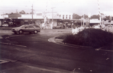
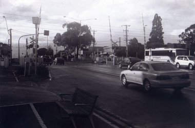
Photograph, Railway crossing on Springvale Road, 1/06/2009
One of a collection of photographs taken of the Nunawading Railway Station prior to the lowering of the railway line and building of the new railway station on the western side of Springvale Road so that the Springvale Road Rail Crossing can be eliminated.Black & white photograph of the precinct surrounding the Nunawading Station and the Springvale Road Railway crossing. This photograph is the railway crossing with Springvale Road, Nunawading, taken from the north west corner looking over crossing to some of the Nunawading shops. See NP 3545 to NP3567 for the complete set of photographsnunawading railway station, springvale road nunawading, redevelopment of railway line/springvale road., nunawading recreation centre -
 Whitehorse Historical Society Inc.
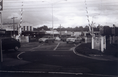
Photograph, Railway Crossing from the north, 1/06/2009
One of a collection of photographs taken of the Nunawading Railway Station prior to the lowering of the railway line and building of the new railway station on the western side of Springvale Road so that the Springvale Road Rail Crossing can be eliminated.Black & white photograph of the precinct surrounding the Nunawading Station and the Springvale Road Railway crossing. This photograph is of the railway crossing of Springvale Road, Nunawading, looking to the south of the shops. See NP 3545 to NP3567 for the complete set of photographsnunawading railway station, springvale road nunawading, redevelopment of railway line/springvale road. -
 Whitehorse Historical Society Inc.
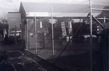
Photograph, Site Office for the Construction of new crossing and station, 1/06/2009
One of a collection of photographs taken of the Nunawading Railway Station prior to the lowering of the railway line and building of the new railway station on the western side of Springvale Road so that the Springvale Road Rail Crossing can be eliminated. Black & white photograph of the precinct surrounding the Nunawading Station and the Springvale Road Railway crossing. This photograph is of the Site Office for the work associated with lowering of railway line and construction of new railway station. See NP 3545 to NP3567for the complete set of photographsnunawading railway station, redevelopment of railway line/springvale road., springvale road nunawading -
 Whitehorse Historical Society Inc.
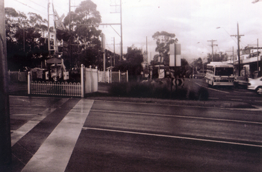
Photograph, Pedestrian Crossing & Nunawading Railway Station, 1/06/2009
One of a collection of photographs taken of the Nunawading Railway Station prior to the lowering of the railway line and building of the new railway station on the western side of Springvale Road so that the Springvale Road Rail Crossing can be eliminated.Black & white photograph of the precinct surrounding the Nunawading Station and the Springvale Road Railway crossing. This photograph is looking over the south side of the intersection in Springvale, to the pedestrian crossing and the Railway Station. The shopping centre is on the right hand side. See NP 3545 to NP3567 for the complete set of photographsnunawading railway station, springvale road nunawading, redevelopment of railway line/springvale road. -
 Whitehorse Historical Society Inc.
Photograph, Railway Crossing from the south, 1/06/2009
One of a collection of photographs taken of the Nunawading Railway Station prior to the lowering of the railway line and building of the new railway station on the western side of Springvale Road so that the Springvale Road Rail Crossing can be eliminated.Black & white photograph of the precinct surrounding the Nunawading Station and the Springvale Road Railway crossing. This photograph is south side of the crossing looking north. See NP 3545 to NP3567 for the complete set of photographsnunawading railway station, springvale road nunawading, redevelopment of railway line/springvale road. -
 Whitehorse Historical Society Inc.
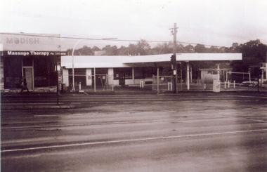
Photograph, Site of new Nunawading ALDI Store, 1/06/2009
Black & white photograph of the site of the proposed new Nunawading ALDI store. The site was the former Caltex Service Station in Springvale Road, Nunawading on the east side and south of the railway line.springvale road nunawading, aldi, caltex service station -
 Whitehorse Historical Society Inc.
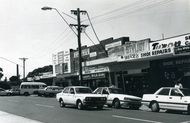
Photograph, Nunawading Shopping Centre
A black and white photograph of the Nunawading shopping Centre taken from the south of the railway stationnunawading shopping centre, shopping centres, nunawading -
 Whitehorse Historical Society Inc.
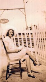
Print - Photograph, Windsor Family, c1940
By1880 most railway crossings were identified by a sign, although at very busy crossings a watchman was posted. Eventually most stations were manned and gates were installed. The watchman was generally housed in a small wooden or brick building with a clear view of the single line. The next stage was mechanical closing of the gates, using a lever situated in a shed behind the gatehouse. By 1956 automatic barriers had been installed. A working model of the gate style crossing can be seen at New Street Brighton.A collection of 12 black and white photographs of the Windsor family who lived in the gatehouse next to the Tunstall station. The stationmaster Ernest Windsor was also responsible for track maintenance between Ringwood and Middleborough Road Box Hill. His wife Betty Jean Windsor was gatekeeper for 2 years. On the back of each photograph are the names of the family members in the photo.Catherine Ann Windsor (born 1897), John Ernest (Ern) WIndsor, Catherine (Kitty) Windsor (born 1919), Patricia Janette WIndsor (born 1935) Tunstall Railway Gatesstationmasters, tunstall station, windsor ernest, windsor catherine, windsor patricia, windsor betty, windsor catherine (kitty) -
 Whitehorse Historical Society Inc.
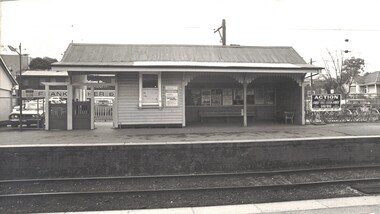
Photograph - Black & white photo, Blackburn Railway Station, 1978
Used by the donor in 'Blackburn - a picturesque history'Black & white photo of south side Blackburn Railway Station 1978blackburn railway station, railways -
 Whitehorse Historical Society Inc.
Document, The Widow and the Con Man
The account of how Dora May Weaver was duped out of money by George Ravennon-fictionThe account of how Dora May Weaver was duped out of money by George Ravenweaver dora may, raven george, tunstall railway station -
 Whitehorse Historical Society Inc.
Document, Heatherdale Spur, 18/11/2022
The history of Heatherdale Spur and the construction of the railway stationnon-fictionThe history of Heatherdale Spur and the construction of the railway stationheatherdale railway station, heatherdale community action group inc. -
 Ballarat Tramway Museum
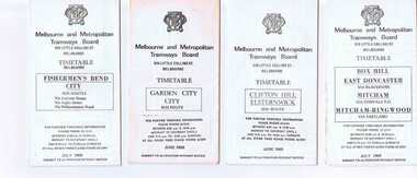
Ephemera - Timetable/s, Melbourne and Metropolitan Tramways Board (MMTB), Set of 14 MMTB Melbourne bus timetables, 1969
Set of 14 MMTB timetables for various bus routes, dated July 1969. Generally includes Sat and Suns, Good Friday and Christmas day as well as weekdays, unless noted otherwise. Also includes a map of the route, detailed time points, sections, connecting services, fares, and organisation address - 616 Little Collins St. Melbourne. Have been folded into eight or ten portions. All on white paper unless noted otherwise. Items shown with an # - have a sticker modifying timetable information details on the front page. Items shown with a % are larger size sheets of paper, folded into 10. 1155.1 - Clifton Hill - Elsternwick # .2 - Garden City - City # .3 - Fishermen's Bend - City .4 - Box Hill - East Doncaster via Blackburn, Mitcham via Donvale PO and Mitcham - Ringwood via Eastland .5 - Warrandyte via Templestowe, via East Doncaster, Donvale PO - City % .6 - Warrandyte, Park Orchards Ringwood .7 - Williamstown Rd., Footscray Railway Station, Ballarat Rd # .8 - Latrobe University, Northland, West Heidelberg - City # % .9 - Deer Park, Sunshine Park, Sunshine, Footscray - City # .10 - as above, but for Saturdays and Sundays on pink paper # .11 - Box Hill, Heidelberg, Templestowe .12 - Box Hill, North Blackburn .13 - East Kew, Box Hill, Doncaster .14 - Bullen, North Kew - City # % Images of a sample of documents added 16-11-2013. mmtb, timetables, melbourne -
 Kew Historical Society Inc
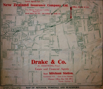
Map - Street Map, R L Jarrett, Map of Mitcham, Tunstall and Blackburn, 1929
Tunstall was originally the name of Nunawading Railway Station. Tunstall opened on 4 June 1888 and was renamed on 1 November 1945. An historically significant advertising map that can be used to ascertain the extent of urban development in 1929 in the areas of Nunawading, Blackburn and Mitcham.A map of Mitcham, Tunstall and Blackburn found on the reverse of a real estate subdivision plan published by R. L. Jarrett of Elizabeth Street. This promotional street map is overprinted with the business address of the sponsors and advertising. Map overlaid in red print: "Drake & Co. / (N. Armstrong, Prop.) / Estate and Financial Agents / next Mitcham Station / Established 1914. Open all day Saturday. / Phones: Office, Box Hill 289 J. / Private, Vermont 10."real estate agents, mitcham, tunstall, blackburn, road maps, drake & co, new zealand insurance co ltd -
 Ringwood and District Historical Society
Book, Elizabeth Dole Porteus, Let's Go Exploring: The Life Of Stanley D. Porteus - Hawaii's Pioneer Psychologist, 1991
White hard covered book. Biography by daughter-in-law of Stanley Porteus, pioneer of modern psychology and one-time resident of Ringwood, Victoria. SUMMARY NOTES. Stanley David Porteus was born in Box Hill, Victoria, Australia in 1883, the only son of a Methodist minister. Like other now large suburbs of Melbourne such as Canterbury, Mitcham and Ringwood, Box Hill was a mere village. Each was surrounded by bush. He grew up like most Australian boys with a love of sport and, although lightly built, did quite well at Australian Rules football and was above average at cricket. He became a schoolteacher with the Victorian Education Department. Promotion within the department depended on experience gained at teaching in tiny rural schools so he applied for such a position at Glenaladale, on the Dargo Road, some 35 miles north west of Bairnsdale. He walked about 6 miles from the nearest railway station at Fernbank to find the school surrounded by virgin forest with only one dwelling in sight. Attached to the school were lean-to rooms that were to be his residence for the next 2 ½ years. He was fascinated by the nearby Den of Nargun and Bull Creek, which joined the Mitchell River in a deep gorge containing a profusion of rainforest vegetation. While at Glenaladale, he met Frances Evans who became his wife. To seek promotion, he left Glenaladale and taught at Leneva and Benambra. While at the latter school, he learned of a position becoming available as superintendent of special schools in Melbourne. As the available means of transport, coach and horses to Bairnsdale, then by train to Melbourne, would not get him to Melbourne before the close of applications, he borrowed a bicycle and rode through the bush to his in-laws home at Lindenow and thus made it before the deadline. He was successful in his application and it set him on a course that lead to him becoming Australia's first Clinical Psychologist. His work, particularly, the development of the Porteus Maze Test, attracted the attention of American educators and he was offered an appointment for a year at Vineland Training School in New Jersey. On a stopover in Honolulu, he was impressed to the extent that he expressed a desire to work there. Not the least of its attractions was the mix of races that offered opportunities to study psychological differences, if any, between various races. His wish was to be granted unexpectedly as he was, in 1919, invited to Honolulu to set up a Psychological and Psychopathic Clinic at the University of Hawaii. From his home in the hills north of Honolulu, on December 7th 1941, he saw the Japanese attack on Pearl Harbour. He lived there until his death in about 1980. -
 Melbourne Tram Museum
Document - Report, Australian Electric Traction Association (AETA), Set of 6 options for Doncaster Light Rail Line, 1991
In 1991, the Australian Electric Traction Association (AETA) produced 7 different options to provide public transport to the Doncaster area. See reference for background to the proposals. Six of the seven options have been found and collected. Each option provides a summary, costing based in a scope of works. The Options were: 1 - Light Rail to Doncaster Shoppingtown via Eastern Freeway/Doncaster Road 2 - Light rail to Mitcham Road/Springvale Road 3 - High-performance train to Doncaster Shoppingtown via Victoria Park station Eastern Freeway/Doncaster Road 4 - Heavy rail to Doncaster Shoppingtown via Eastern Freeway to Bulleen Road and underground to Shoppingtown 5 - Heavy Rail to Blackburn Road/George St East Doncaster 7 - Extension of the Camberwell Tram (72) along Burke Road from Cotham Road to Doncaster Road. Out of all the studies, nothing happened.Yields information about the early 1990s proposal to provide public transport to the Doncaster area.Set of 6 reports or options printed on A4 paper, stapled in top left hand corner.tramcars, tramways, aeta, new tramways, doncaster, railways, light rail -
 Whitehorse Historical Society Inc.
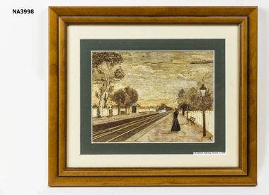
Painting, 2007
Purchased by Society from Jan Robertson, a member of the Art in Bark Association Inc. The painting was copied from a photograph in our collection - NP217 by Jan Robertson of 3/15 Harrison Street Mitcham.A bark painting of Blackburn Railway Station c1918. It is a copy of NP217illustrations, bark -
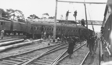 Ringwood and District Historical Society
Photograph, Ringwood railway station precinct - derailment 22/6/1945
A porter illegally in the signal box moved the points under a train coming into the south platform from a siding. The 5th carriage took two lines as shown, and brought down the overhead stanchions over both the passenger and goods lines. For about 36 hours, the service beyond Mitcham was maintained by steam trains connecting with electrics at Mitcham. Men are pictured putting up temporary overhead stanchions over the passenger lines around 10 a.m. on Saturday 22/6/1945 and another photograph shows the steam crane near the signal box lifting the Melbourne end of the derailed carriage. Accompanying typed sheet reads, "...shows the steam crane about outside the signal box lifting the Melbourne end of the derailed carriage". -
 Whitehorse Historical Society Inc.
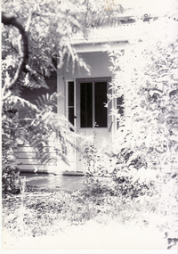
Photograph - Black and white photograph, Station Master's House, Mitcham
Black and white photo of Station Master's House, Mitcham. House at southern end of Station Street - on eastern side - adjacent to railway line. House has been demolished and replaced with car parkingjones, shirley -
 Whitehorse Historical Society Inc.
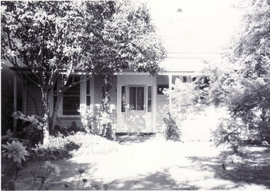
Photograph - B/W Photograph, Station Master's House Station Street Mitcham, 1/09/1976 12:00:00 AM
Black and white photo of Station Master's House, Station Street, Mitcham - was immediately alongside railway line - is now carpark.station master's house, mitcham -
 Ringwood and District Historical Society
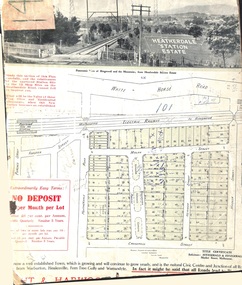
Card - Land Subdivision Clipping, Heatherdale Station Estate, Ringwood, Vic. - circa 1923
Cardboard-backed partial front page copy of a land sale advertisement map with penciled sales notations for some blocks.Subdivision includes Heatherdale Road, Molan Street, Yallourn Parade, Newman Street, and Madden Street. Location map inset shows Purches Street and Forster Street, Mitcham, and approved site for Heatherdale railway station. -
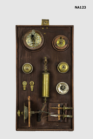 Whitehorse Historical Society Inc.
Equipment - Switches, 1900s
Fittings out of the Mitcham Station Master's house, the last block of land on the east side of Station Street, now a car park. Railway Department house number 1273 brass and ceramic light switches. 2 brass picture hooks. 1 brass and lead counterweight for lamp. 2 gas jets on wooden base. 1 door bell pull. 2 brass curtain holders. All on wooden base.metalcraft, brassware