Showing 891 items
matching network
-
 Box Hill Historical Society
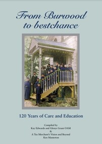
Book, From Burwood to bestchance : 120 years of care and education, 2016
Illustrated history of Burwood Boys Home, Child and Family Care, and bestchance, Child, Family Care. From original beginnings in 1895 when founder Robert Campbell Edwards established a home for the waifs of Melbourne, to the present organisation caring for families and children, providing child care, early intervention programs, special primary education ( Cheshire School) and adult training. In 2007, Ken Masterton's book "A Tea Merchant's Vision and Beyond - a history of the Burwood Boys' Home" (which is reproduced in full in this edition) begins with the vision of tea merchant Robert Campbell Edwards and "gives a valuable summary of the organisation's achievements".xvi, 202 pages : illustrations (some colour), portraits (some colour), colour maps; includes Appendices lists of leadership and Life Governors 1895 to 2016 non-fictionIllustrated history of Burwood Boys Home, Child and Family Care, and bestchance, Child, Family Care. From original beginnings in 1895 when founder Robert Campbell Edwards established a home for the waifs of Melbourne, to the present organisation caring for families and children, providing child care, early intervention programs, special primary education ( Cheshire School) and adult training. In 2007, Ken Masterton's book "A Tea Merchant's Vision and Beyond - a history of the Burwood Boys' Home" (which is reproduced in full in this edition) begins with the vision of tea merchant Robert Campbell Edwards and "gives a valuable summary of the organisation's achievements".burwood boys' home, child care, burwood children's home, bestchance, family day care -
 Marysville & District Historical Society
Ephemera (Item) - Information sheet, Disney Entertainment Pty Ltd, JIM BROWN VISITS MARYSVILLE, 1995
An information sheet about Episode 12 of the television program Healthy Wealthy and Wise from May 1995. Healthy, Wealthy and Wise was a lifestyle television program shown in Australia. It was shown on Network Ten and was aired from 1992 until 1998. Jim Brown was the program's travel presenter.An information sheet pertaining to Episode 12 of the television program healthy wealthy & wise from May, 1995.EP. 12. MONDAY, 1st May, 1995marysville, victoria, australia, information sheet, healthy wealthy and wise, jim brown, stevensons falls, steavenson falls, lady talbot drive, lady talbot forest drive, cumberland reserve, valley of the giants, david rackman, dalrymples guest cottages, maryton park, mathilde's of marysville, lake mountain, disney entertainment pty ltd -
 Kew Historical Society Inc
Slide - Fort Queenscliff, 1980
Established in 1966, the Committee of Eastern Historical Societies (CEHS) was a network of historical societies in the region east of Melbourne. Kew Historical Society was a member of CEHS in 1980 when this tour of Queenscliff was organised and held. The photograph is one of eight taken on the tour by a member of the Society and later donated to the collection.35 mm colour transparency (slide) of Fort Queenscliff, taken on a tour by the Association of Eastern Historical Societies (AEHS) in 1980."First Building at Fort Queenscliff C of EHS Tour 1980"queenscliff -- victoria, committee of eastern historical societies (cehs), khs-slides -
 Kew Historical Society Inc
Slide - Fort Queenscliff, 1980
Established in 1966, the Committee of Eastern Historical Societies (CEHS) was a network of historical societies in the region east of Melbourne. Kew Historical Society was a member of CEHS in 1980 when this tour of Queenscliff was organised and held. The photograph is one of eight taken on the tour by a member of the Society and later donated to the collection.35 mm colour transparency (slide) of Fort Queenscliff, taken on a tour by the Association of Eastern Historical Societies (AEHS) in 1980."Tower at Fort Queenscliff 1980"queenscliff -- victoria, committee of eastern historical societies (cehs), khs-slides, fort queenscliff -
 Kew Historical Society Inc
Slide - The Ripp from Fort Queenscliff, 1980
Established in 1966, the Committee of Eastern Historical Societies (CEHS) was a network of historical societies in the region east of Melbourne. Kew Historical Society was a member of CEHS in 1980 when this tour of Queenscliff was organised and held. The photograph is one of eight taken on the tour by a member of the Society and later donated to the collection.35 mm colour transparency (slide) of 'The Ripp' as viewed from Fort Queenscliff, taken on a tour by the Association of Eastern Historical Societies (AEHS) in 1980."The Ripp from Fort Queenscliff C of EHS Tour 1980"queenscliff -- victoria, committee of eastern historical societies (cehs), khs-slides, fort queenscliff, the ripp -- the heads -- port philip bay -
 Kew Historical Society Inc
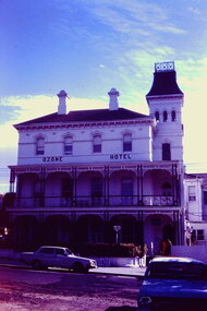
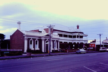
Slide - Ozone Hotel, Queenscliff, 1980
Established in 1966, the Committee of Eastern Historical Societies (CEHS) was a network of historical societies in the region east of Melbourne. Kew Historical Society was a member of CEHS in 1980 when this tour of Queenscliff was organised and held. The photograph is one of eight taken on the tour by a member of the Society and later donated to the collection.35 mm colour transparency (slide) of the Ozone Hotel, Queenscliff, taken on a tour by the Association of Eastern Historical Societies (AEHS) in 1980."Queenscliff 1980"queenscliff -- victoria, committee of eastern historical societies (cehs), khs-slides, ozone hotel -
 Kew Historical Society Inc
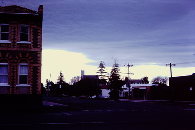
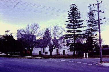
Slide - Queenscliff, 1980
Established in 1966, the Committee of Eastern Historical Societies (CEHS) was a network of historical societies in the region east of Melbourne. Kew Historical Society was a member of CEHS in 1980 when this tour of Queenscliff was organised and held. The photograph is one of eight taken on the tour by a member of the Society and later donated to the collection.35 mm colour transparency (slide) of Queenscliff, taken on a tour by the Association of Eastern Historical Societies (AEHS) in 1980."Queenscliff 1980 C of EHS Tour"queenscliff -- victoria, committee of eastern historical societies (cehs), khs-slides -
 Kew Historical Society Inc
Slide - Queenscliff, 1980
Established in 1966, the Committee of Eastern Historical Societies (CEHS) was a network of historical societies in the region east of Melbourne. Kew Historical Society was a member of CEHS in 1980 when this tour of Queenscliff was organised and held. The photograph is one of eight taken on the tour by a member of the Society and later donated to the collection.35 mm colour transparency (slide) of Queenscliff, taken on a tour by the Association of Eastern Historical Societies (AEHS) in 1980."Queenslciff East Org? His Tour 1980"queenscliff -- victoria, committee of eastern historical societies (cehs), khs-slides -
 Kew Historical Society Inc
Slide - Queenscliff, 1980
Established in 1966, the Committee of Eastern Historical Societies (CEHS) was a network of historical societies in the region east of Melbourne. Kew Historical Society was a member of CEHS in 1980 when this tour of Queenscliff was organised and held. The photograph is one of eight taken on the tour by a member of the Society and later donated to the collection.35 mm colour transparency (slide) of Queenscliff, taken on a tour by the Association of Eastern Historical Societies (AEHS) in 1980."C o EHS Tour Queenscliff 1980"queenscliff -- victoria, committee of eastern historical societies (cehs), khs-slides -
 Kew Historical Society Inc
Slide - Row of terraces, Queenscliff, 1980
Established in 1966, the Committee of Eastern Historical Societies (CEHS) was a network of historical societies in the region east of Melbourne. Kew Historical Society was a member of CEHS in 1980 when this tour of Queenscliff was organised and held. The photograph is one of eight taken on the tour by a member of the Society and later donated to the collection.35 mm colour transparency (slide) of Queenscliff, taken on a tour by the Association of Eastern Historical Societies (AEHS) in 1980."Terrace House Queenscliff 1980"queenscliff -- victoria, committee of eastern historical societies (cehs), khs-slides -
 Ballarat Heritage Services
Photograph - Colour, Central Highlands Historical Association Expo, c 1996
Central Highlands Historical Association [CHHA] is a vital link in the regional history network being the umbrella association for over 30 historical societies, museums and family history organisations in the central highlands region of Victoria. CHHA continues to be an active and innovative organisation. It is represented at Local and State levels on matters of joint concern to its members. Aims and Purposes: Formed in 1984 the inaugural CHHA meeting was held on Saturday 23 June 1984, at the Ballarat City Library in Camp Street, Ballarat. A main focus of CHHA is to assist its member societies by developing and maintaining resources and information networks. To promote history and heritage in the region To encourage the preservation and conservation of heritage To promote and encourage easier public access to records through local museums and societies 6 coloured photographs postcard sizenonechha, central highlands historical association, dorothy wickham, clare gervasoni, raymond shuey -
 Bacchus Marsh & District Historical Society
Map, Subdivision of the Manor House Property Bacchus Marsh c.1908
This land sales plan shows allotments of land offered for sale in the inner township area of Bacchus Marsh in 1908. The land put up for sale was from the estate of the late Mr and Mrs J.E. Crook. That being James Elijah Crook and his wife Harriet, (nee Athorn). The Crooks had been resident in Bacchus Marsh since the 1840s and were prominent members of the community. They were prominent in the business, social and civic affairs of the town and district. In the 1850s the Crooks acquired the Manor House and nearby land once owned by the Bacchus family. James Crook died in 1889. When Harriet Crook died in February 1908 their estate was offered for sale. This included the large stone home known as the Manor House and various parcels of land including around 50 allotments of land near the Manor House, bounded by Young, Lerderderg, Crook and Main Streets. Most of these allotments of land were sold in October 1908. The Manor House itself was passed in at the sale and continued to be owned by the Crook family for several decades after 1908.A single page map on a single page of a bound volume of maps. The map shows portions of land for sale from the subdivision of the Manor House property in Bacchus Marsh in 1908. The names of most of the buyers of the portions of land have been hand-written into the various allotments they purchased. The maps are pasted into a bound volume containing 76 maps or plans in total. High resolution digital image stored on BMDHS computer network. bacchus marsh victoria maps, land sales bacchus marsh, manor house bacchus marsh, crook family bacchus marsh -
![Map, Plan of Subdivision [Allotments along Lerderderg, George and McFarland Streets]](/media/collectors/5e461d8021ea67224c82f2a1/items/675d7243165f146b8adfc656/item-media/675d72d7165f146b8adfc859/item-fit-380x285.jpg) Bacchus Marsh & District Historical Society
Bacchus Marsh & District Historical SocietyMap, Plan of Subdivision [Allotments along Lerderderg, George and McFarland Streets]
This map shows allotments of land on the northern side of Lerderderg Street from Gisborne Road through to the approximate site of the present day Bacchus Marsh Primary School. There are also allotments shown on the southern side of McFarland Street between George Street and Gisborne Road. Larger allotments of land are shown extending northwards towards Masons Lane. Inscribed at the top of the map are the words, 'Plan of Subdivision of Cr Pors (Crown Portions) 12 & 13 & Allotments 1,2,3,4, Block 3, Parish of Korkuperrimul, County of Bourke'. The date of the map has not been established but the absence of the Bacchus Marsh Primary School on the map suggests it may have been produced prior to 1865 when the primary school was built in Lerderderg Street.Single page map showing house block size land allotments in the Lerderderg, George Street and McFarland Street area of Bacchus Marsh with larger allotments north of this area towards Masons Lane also shown. Scale 150 feet to 1 inch. Part of a set of maps which are pasted into a bound volume containing 76 maps or plans in total. High resolution digital image stored on BMDHS computer network. bacchus marsh victoria maps, lerderderg street land allotments, mcfarland street land allotments -
 Melbourne Tram Museum
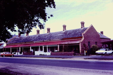
Document - Report, Public Transport Unions and Victorian Trades Hall Council, "Union Metplan - August 1988", Aug. 1988
Report - summary - folded A3 sheet titled "Union Metplan - August 1988". Gives a summary of the August 1988 report - see Reg Item 345, submission by the Public Transport Unions to Government. Outlines the Benefits, expanding the train and tram system, bus network, increasing patronage, workshops, funding and employment. Has a photo of John Halfpenny launching the plan at Caulfield station, August 1988 with the MTA band in the foreground.trams, tramways, the met, reports, melbourne, mta, atmoea, unions, metplan, tramway band -
 Melbourne Tram Museum
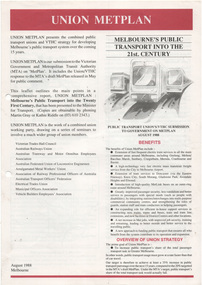
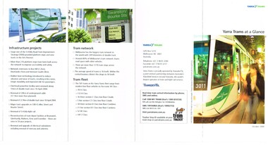
Pamphlet, Yarra Trams, "Yarra Trams at a Glance", Apr. 2008
Pamphlet - DL size, 5 fold printed in full colour on white paper, titled "Yarra Trams at a Glance". Gives details of the services, staff, state projects, tram fleet upgrade, innovation, Tram Tracker, awards, infrastructure projects, the network, tram fleet and contact details. Has the logos of Yarra Trams - Dated April. 2008. See Reg Item 1124 for the Oct. 2008 issue. Two copies held.trams, tramways, yarra trams, logos, tramcars, information -
 Melbourne Tram Museum
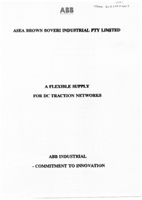
Document - Report, ASEA Brown Boveri Industrial Pty Ltd, "A Flexible Supply for DC Traction Networks", 1991
Report or Specification 8 A4 pages, photocopied held within a clear plastic folder with a black binding strip on the left hand side, titled "A Flexible Supply for DC Traction Networks". Produced by ASEA Brown Boveri Industrial Pty Ltd, 1991 giving details of mobile substations, characteristics, and the equipment provided including a photograph. Lists substations provided between 1984 to the MTA, South Australia, Skitube, and the PTC.In ink on the top right hand corner "1991 Tram Substations"trams, tramways, ptc, substation, asea, power supply, mta -
 Melbourne Tram Museum
Pamphlet, Yarra Trams, "Yarra Trams at a Glance", Oct. 2008
Pamphlet - DL size, 5 fold printed in full colour on white paper, titled "Yarra Trams at a Glance". Gives details of the services, staff, state projects, tram fleet upgrade, innovation, Tram Tracker, awards, infrastructure projects, the network, tram fleet and contact details. Has the logos of Yarra Trams, TransdevTSL and Tram Tracker. Dated Oct. 2008. See Reg item 2397 for an April 2008 issuetrams, tramways, yarra trams, transdev, logos, tramcars, information -
 Melbourne Tram Museum
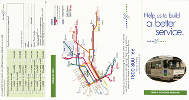
Pamphlet, Yarra Trams, "Help us to build a better service", 2001
Pamphlet - four fold DL - gloss paper, titled "Help us to build a better service", asking Yarra Trams (prior to amalgamation of M>Tram) passengers, survey, about the appearance of the new Yarra trams livery, inside and outside, security cameras, and information provided. Has a map of the Yarra tram routes, or network. Include contact number and logos. Dated 2001 and signed by Steve MacDonald as CEO of Yarra Trams.trams, tramways, yarra trams, livery, surveys, map -
 Melbourne Tram Museum
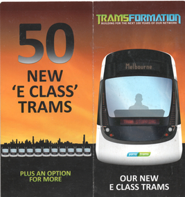
Pamphlet, "Tramsformation - our new E class trams", c2013
Pamphlet produced by Yarra Trams at the time of the construction of the first 50 E class tras. Gives design features, where being built, initial use on route 96, changes to depot allocation of trams, and other network changes. E class trams commenced running during 2013.Yields information about the introduction of the E class tram in 2013.Pamphlet - 2 fold DL full colour.tramways, tramcars, e class, route 96, new trams -
 Vision Australia
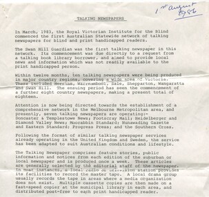
Document - Text, Talking Newspapers - 1st August 1986, 1/8/1986
In 1983 the Swan Hill Guardian became the first Talking Newspaper produced by the RVIB. In the three years since then 18 other rural newspapers followed and in 1986 there was a concerted push to add Melbourne papers to this network. This document provided an outline of the process of establishing a paper, and the role community groups and public libraries played in this.2 foolscap page document about the Talking Newspaper Serviceroyal victorian institute for the blind, talking newspaper service -
Ballarat Tramway Museum
Newspaper, The Courier Ballarat, "Let us envisage future demands" - Courier Editorial, 22/11/1971 12:00:00 AM
Newspaper clipping from The Courier, 22/11/1971 - editorial item - about the consideration by the City Council for a tourist tram network in Ballarat. Mentions that though Bendigo saved a substantial part of its system through Government approval, it barely caused a tremor in Ballarat. Mentions BTPS seeking approval for the Botanical Gardens, the demolition of the system in the centre of Ballarat, money given to Sovereign Hill. Finishes by seeking support for 'our new tram venture'.trams, tramways, courier editorial, city of ballarat, museum establishment, bendigo, btps, demolition -
 Bacchus Marsh & District Historical Society
Map, Allotments in the Village of Rowsley, Parish of Gorrocburkghap, County of Grant c.1856
Rowsley is a locality 11 kilometers south-west of Bacchus Marsh. The date of this map is uncertain. A very similar map held by the State Library of Victoria (SLV) contains slightly more information than this copy and is dated as an 1856 map. SLV reference: 'Allotments in the Village of Rowsley, Parish of Gorrocburkghap, County of Grant', by T. Nixon, Assistant Surveyor, May 1856 ; Surveyor General’s Office, July 18 1856 (lithographed by R. Meikle). (1856). Melbourne: Surveyor General’s Office. MAPS 820 BJE 1837- ROWSLEY 1856. A single page paper map. A cadastral map of the Village of Rowsley in Victoria, showing numbered land allotments. 57 allotments are shown on the map and some areas set aside as reserves. Allotments 8, and 10-16 are outlined in red ink and allotment 9 has a cross in red ink on it. The map is pasted into a bound volume containing 76 maps or plans in total. High resolution digital image stored on BMDHS computer network. rowsley victoria history, rowsley victoria maps -
 Melbourne Tram Museum
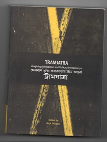
Book, Mick Douglas, "Tramjatra - imaging Melbourne and Kolkata by tramways", 2005
Book - 304 pages, plus card cover with fold out section both ends, perfect bound, titled "Tramjatra - imaging Melbourne and Kolkata by tramways" (Calcutta), edited by Mick Douglas, published by RMIT University Press, 2005. Tram journeys. Has a table of contents, with a side by side page translation - English and Bagla looking at journeys, passengers, the networks and images on the Melbourne and Kolkata tramway systems. Provides list of contributors, images.trams, tramways, melbourne, calcutta, tramways, rmit -
 Melbourne Tram Museum
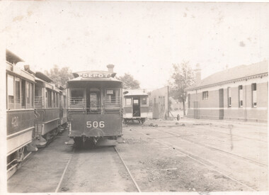
Photograph - Clifton Hill depot and cable trailers, c1941
Photograph, shows cable trailers 506 and 420 in the yard at Clifton Hill depot or car house, after the closure of the cable tram network in Oct. 1940. In the background is a partially dismantled trailer, a wheel set, and the traverser. A free standing wall section is in the photograph as well. Second photo is a side of view of tram 420.Yields information about Clifton Hill depot after the closure of the cable tram network and the disposal of tramcars.Set of 2 Black and white photographs with notes on the rear. Has on the rear in pencil number "61" and "147"tramways, cable trams, clifton hill cable tram depot, clifton hill, sale of trams, tram 506, tram 420 -
 Bacchus Marsh & District Historical Society
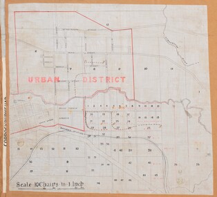
Map, Bacchus Marsh Urban District
The date of this map has not been established but the date would be sometime after 1887 as the Bacchus Marsh Railway Station, which opened in 1887, is shown on the map. A single page paper map showing blocks of land in the urban district of Bacchus Marsh. The 'urban district' is indicated by red drawn lines on the map and includes streets and blocks on the northern side of the Werribee River in Bacchus Marsh, and streets and blocks south of the Werribee in Maddingley. Scale 10 chains to 1 inch. The map is pasted into a bound volume containing 76 maps or plans in total. High resolution digital image stored on BMDHS computer network. bacchus marsh victoria maps, maddingley victoria maps -
 Melbourne Tram Museum
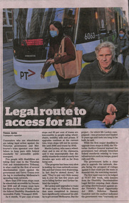
Newspaper, The Age, "Legal route to access for all”, 28/06/2021 12:00:00 AM
Newspaper clippings titled: "Legal route to access for all” by Timna Jacks Newspaper clipping from the Age 28/06/2021 Wheelchair commuters take legal action against Victorian government and Yarra Trams over failure to provide wheelchair access across Melbourne's tram network. Currently 73% of tram stops and 62% of trams are inaccessible to people using wheelchairs, mobility aids and prams. Cost of upgrading remaining tram stops is $2 billion.trams, tramways, yarra trams, safety, accessible transport -
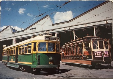 Kew Historical Society Inc
Postcard, Biscay Greetings Pty Ltd, Trams at Kew Depot, c.1991
The Kew tram depot is located on the corner of Barkers Road and High Street, Kew. It is one of eight tram depots on the Melbourne tram network. The depot opened on 8 May 1915. The main yard has 12 covered roads. There are two tracks for trams leaving or entering via Barkers Road, and a single track connecting to High Street.Postcard produced c.1991 to commemorate 75 Years of Service of The Kew Depot (1915/16-1991). The postcard shows two trams at the depot. The details are included in the information provided on the reverse.Kew Depot is ready for work W Class 892 waits for its next duty while visiting V Class 214 is ready for special work Photo by R. J. Marsh T101 Copyright Biscay Greetings Pty Ltd Telephone (03) 562 3599tramways - kew, kew tramways depot, -
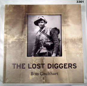 Bendigo Military Museum
Book - BOOK WW1, Ross Coulthart, The Lost Diggers, c.2011
The Lost Diggers. (Photos from WWI). From acknowledgements: This book was conceived out of the extraordinary public response we had on the Seven TV Network's Sunday Night public affairs program to several stories presenting The Lost Diggers images. From preface: Swarthy Anzacs, village of Vignacourt, photographs taken by local photographers Louis & Antoinette Thuillier.Hard cardboard cover, buckram texture, with sepia coloured faded photo background. Cut out panel on front, see through to black & white 1/2 portrait photo of uniformed soldier. Dark brown print front & spine, some white on back. Brown ribbon page marker. Front & back end papers & flyleaf, black & white photos. 399 pages, cut glossy white. Illustrated black & white, colour & sepia photos.book, photographs, lost diggers -
Greensborough Historical Society
DVD, Channel 5 Productions et al, The Inner Circle Railway Line, 1888o
The Inner Circle was a steam era suburban railway line (later electrified) in Melbourne, Australia. It served the inner-northern suburbs of Parkville, Carlton North, Fitzroy North, and Fitzroy and later expanded to outer suburbs. It opened in 1888. In this video, the viewer is taken on a train journey around the Melbourne rail network and also looks at the stations and lines that have since closed.Original footage of Melbourne's railways.1 x DVD in black case. DVD of approx 43 minutes.melbourne rail network, transportation, railways -
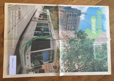 Melbourne Tram Museum
Newspaper, The Age, "Moving Forward", 29/10/2001 12:00:00 AM
Eight page, Newspaper supplement to The Age, Monday October 29, 2001 titled "Moving Forward" - A passenger transport supplement - or "Why Melbourne's tram, train and bus network is travelling in the right direction. Features a photo of C 3001 travelling west in Collins St. Includes articles and statements on vision of the various operators, tram, train and bus, VicTrip, one link, Metcards, buses and the Camberwell Junction project "Let there be light". Adverts from Metcard, Karcher, Yarra Trams and Connex.Label on front page "The Age Monday, October 29, 2001".trams, tramways, yarra trams, m>tram, metcard, melbourne, public transport, camberwell junction, tram 3001