Showing 1012 items matching "paddock"
-
 University of Melbourne, Burnley Campus Archives
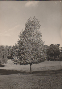
Photograph - Black and white print, A.W. Jessep, Golden Poplar, 1931
Black and white photograph. Golden Poplar in the Lagoon Paddock. See B11.0339(9)Handwritten on reverse, "Golden Poplar 1931," "Slide" (glass slide). golden poplar, trees, lantern slides, lagoon paddock -
 Southern Sherbrooke Historical Society Inc.
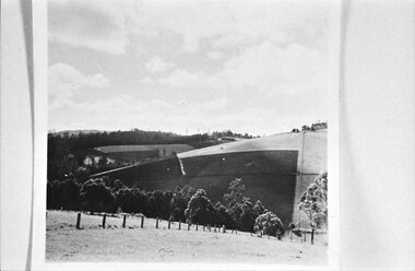
Photograph
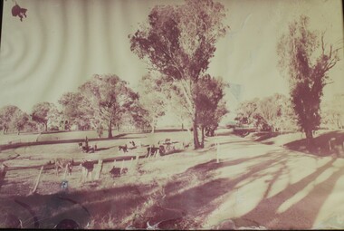
Fenced paddocks dotted with trees. Rows of trees on a ridgeline. A house is visible on the left. -
 University of Melbourne, Burnley Campus Archives
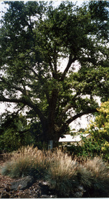
Photograph - Colour print, Elm Tree, 2005
Colour Photograph. Old Elm tree near the Bull Paddock with the Dairy in the background. "Burnley 05."elm, trees, dairy -
 Ringwood and District Historical Society
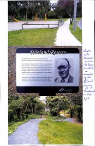
Photograph, 3 photographs of the Wieland Reserve in Heathmont, Victoria, with notes 2010
Wieland Family were early Orchardists in the Heathmont area.1. Photograph of the Wieland's old horse paddock now Wieland Park' 2. Photograph of the Plaque with Stanley Wieland's image and text of the history of the reserve formerly the horse paddock and dam. 3.Photograph of the. Old house site -
 Orbost & District Historical Society
black and white photograph, 1907
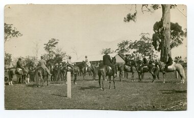
This photograph shows the show ring at the Orbost Annual Agricultural Show in 1907. The first meeting to form an Agricultural society in Orbost was convened by the then Orbost Progress Association and held in the Mechanics Hall on Saturday, 10th October 1891. Its first show was held on 3rd March 1904...on a site alongside the Bonang Road where the present Golf Club stands. It is currently held at the Recreation Reserve at Newmerella. (Ref: In Times Gone By-Deborah Hall) This item is associated with the Orbost Agricultural Society 's Annual Show which has been a major event in Orbost for over a century. Agricultural shows are an important part of cultural life in small country towns and the Orbost Show is an integral part of Orbost 's agricultural history. A black / white photograph of a large group of riders on horseback. They are in a paddock. In the background is a wooden building.on back - "Orbost Agric. Show Ring, 1907, Mrs A M Marshal East Bairnsdale"orbost-agricultural-show-event -
 Glenelg Shire Council Cultural Collection
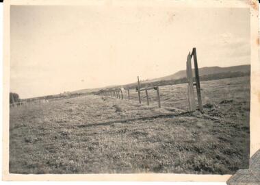
Photograph - Photograph - Fenced paddocks, scattered trees, barbed wire fence in foreground, n.d
Black and white photograph. Fenced paddocks, scattered trees, barbed wire fence in foreground.Back: 'Press Photographic Service' purple stamp 5/A pencil -
Glenelg Shire Council Cultural Collection
Photograph - Photograph - Burswood Portland, Victoria, n.d
Black and white photo. View of 'Burswood' in background; surrounded by trees, paddocks and fences in foregroundBack: 'The first home of the Henty's, Portland' - handwritten, black pen -
Glenelg Shire Council Cultural Collection
Photograph - Photograph - Casterton, Victoria, n.d
Sourced from Casterton Town Hall (Former Shire of Glenelg)Black and white photo. Erosion near Casterton, man standing near hole in paddockBack: Round, purple, photographer's stamp -
 Hume City Civic Collection
Photograph
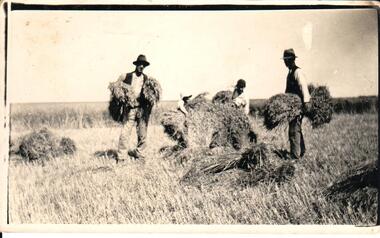
A black and white photograph of four men gathering hay to make hay stooks in a paddock.on back: STOOKING / DIGGERS RESTcullinan, uraina, eileen, bayview farm, diggers rest, harvesting, hay bales, horse drawn vehicles, george evans collection -
 Hume City Civic Collection
Photograph
B/W photograph of a paddock with railings and Mr Holden in the background. (maybe Sunbury racecourse)sunbury racecourse, horse racing, holden, - (mr), racecources, george evans collection -
 University of Melbourne, Burnley Campus Archives
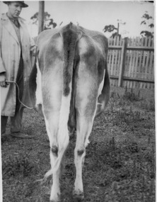
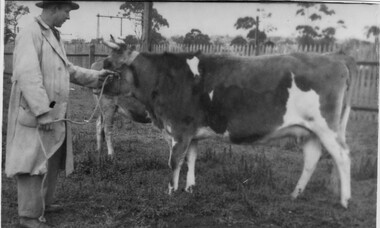
Photograph - Black and white print, Dept pf Agriculture, Victoria, Victoria Fire Flame, Unknown
The negative came from Record Book, Stock Breeding Record [Cows] (B91.453) and is stored with photographs catalogued as B91.71.Black and white photograph. Rear view of Jersey cow held by a man standing in a paddock. On reverse, "Victoria Fire Flame. Height 4ft 1in Length 6ft 3in."cows, stock breeding record, victoria fire flame, jersey cow, stockman, cow uddder, butter fat -
 Whitehorse Historical Society Inc.
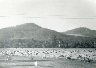
Photograph, Till
Black and white print of hills with a hay paddock and animals in foreground. Overhead power lines.till agriculture -
 Southern Sherbrooke Historical Society Inc.
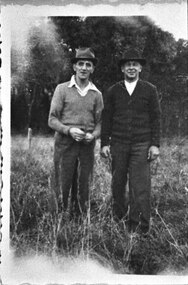
Photograph - Bill Slingo Senior and Ted Stimpson
Photograph features two men in hats standing side by side in a paddock with trees in the background. -
 Wodonga & District Historical Society Inc
Photograph - Photo - Felltimber Creek Road, Wodonga, Neil Coles, July 1984
Felltimber Creek Road is on the south-eastern edge of West Wodonga. It was originally covered in bushlandA large black and white image of cows grazing in a paddock. Image is in a metal and glass frame.felltimber creek, wodonga 1980s, wodonga scenes -
 Linton and District Historical Society Inc
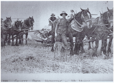
Photography, Gillett Bros. Harvesting at Mt Mercer
Photocopy of mounted photograph no.510, showing 2 teams of horses and men harvesting a paddock.gillett, harvesting, farming, horses, mt mercer -
 Bendigo Historical Society Inc.
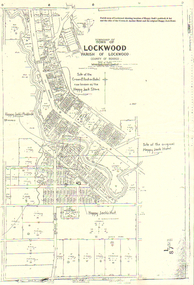
Map - LONG GULLY HISTORY GROUP COLLECTION: LOCKWOOD TOWNSHIP
Copy of a map of Township of Lockwood, County of Bendigo. Printed at the top of the map is: Parish map of Lockwood showing location of Happy Jack's paddock & hut and the sites of the Crown & Anchor Hotel and the original Happy Jack Hotel. Written on the map with arrows pointing to the site is: Happy Jack's Paddock, Site of the original Happy Jack Hotel and Happy Jack's Hut. An outline of Happy Jack's Paddock is drawn in.bendigo, history, long gully history group, the long gully history group - lockwood township, crown & anchor hotel, happy jack hotel, happy jack store, county of bendigo -
 Cheese World Museum
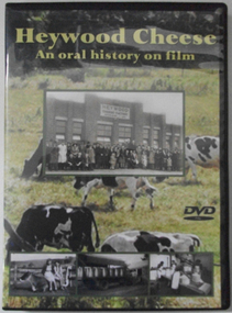
DVD, Heywood Cheese; an oral history on film
For many years the Heywood Cheese Factory was an important part of life for Heywood and district farming and a vital place of employment for up to 40 men and 10 women. The factory opened in 1939 as a subsidiary of the Portland Butter Factory before becoming a world renowned cheese making enterprise. It was felt important to document its history from the surviving factory workers, including dairy suppliers and milk truck drivers. We hear their stories of the long hours and hard work without penalty rates, travelling unsealed roads and mixed with their humour of the bygone days is an important acknowledgement of that era. [blurb on back cover]This oral history provides significant material relating to the dairy industry in south west Victoria during the mid 20th century. The interviews give first-hand recollections of the interviewees involvement in the industry from a point of view of factory workers, milk pick-up drivers and farmers.Full colour DVD cover has photograph of Heywood Cheese factory and photographs of girls with calves, milk cans on a truck and workers in the cheese room, superimposed on a photograph of dairy cows grazing in a paddock. The DVD has the photograph of the cows grazing in the paddock.Heywood Cheese/An oral history on film (front) For many years Heywood Cheese Factory was ... [see historical information] Edited by Garry Kerr for the Heywood Pioneer Wagon Shed/ Museum History Group who wish to gratefully acknowledge the/ support of the Victorian Government and Public Records Office/ Victoria for making this project possible. Duration: 70 minutesallansford, heywood, cheese factories, cheese manufacturing, dairying, cheese -
 Surrey Hills Historical Society Collection
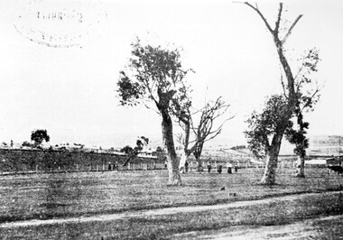
Photograph, Surrey Hills Golf Club - looking towards Doncaster, 1902, 1902
Reproduced by permission of Mr John Arnold from his book: "The Riversdale Golf Club - a history, 1892-1977." Copyright to book: Riversdale Golf Club. Surrey Hills Golf Club operated from 1892-1908 then moved and became Riversdale Golf Club. The game was played across paddocks from Trafalgar Street, Mont Albert to Whitehorse Road and down Victoria Crescent to where Box Hill TAFE is now located in Elgar Road. There were problems with cows eating the tee flags! The clubhouse still exists as 30 Trafalgar Street.This image is important for reference to the landscape and vegetation prior to urbanisation.Black and white photo in the foreground of which is a path running diagonally from left to right. Behind are 5 mature trees whose condition is not vigourous (showing signs of die-back). Several figures are beneath the trees, behind which is a post-and-wire fence, paddocks and distant houses. There is the shadow of a stamp in the top LH corner, suggestive of this having been copied from an earlier image.Caption: "Top: Looking towards Doncaster from the links in 1902."sports grounds, surrey hills golf club, riversdale golf club, john arnold -
 Orbost & District Historical Society
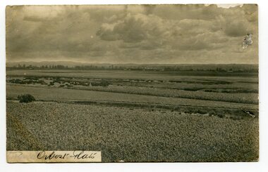
black and white photograph, Sherwood, first half 20th century
This postcard is addressed to Tom Lloyd from Uncle Frank c/o F. Lloyd Esq, Bairnsdale.This item is a pictorial record associated with the agricultural history of Orbost. .The extensive Snowy river flood plain was swampy, but by the 1880s the river flats were being drained. The Orbost flats are very fertile and crops were planted on the rich deep soil, with maize rapidly becoming widespread.A black / white photograph of the Orbost farming flats. The sky is very cloudy. There are paddocks of crops in the foreground.on front - "Orbost Flats" on back - "How are you enjoying your holiday.......Uncle Frank"orbost-flats-farming lloyd-frank -
 Orbost & District Historical Society
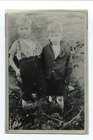
black and white photograph, C1933
The two boys in this photograph are Stanley (7) and Maurice (5) Kelly. The two boys were lost in the bush near Orbost for three days. The had been sent by their mother, Mrs Parker, to borrow tea and sugar from a neighbour but became lost on the way home. They were found, scratched and with clothes torn, by a woodcutter, Mr W. Morell. There was a newspaper article on the front page of the Adelaide Mail , Saturday 22 July 1933,This photograph is linked with an event in Orbost's history.A small black / white photograph / postacrd of two small boys standing side by side in a paddock.on back - "The Kelly Kids, lost near L. Curlip"kelly-maurice kelly-stanley -
Glenelg Shire Council Cultural Collection
Photograph - Photograph - Roadworks, n.d
Sourced from Casterton Town Hall (former Shire of Glenelg)Coloured photograph. Roadmaking between two paddocks. Grader in foreground, other roadmaking equipment in background -
 Victoria Police Museum
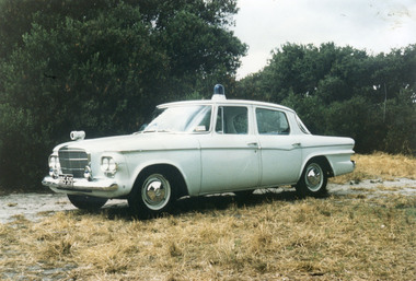
Photograph (police car)
Studebaker Lark Wireless Patrol car registration number HRS-515 in a paddock. Circa 1962police vehicles; wireless patrol; motor transport branch; studebaker lark car -
 Hume City Civic Collection
Photograph
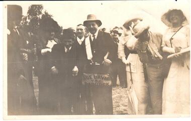
A b/w photograph of people at a race meeting. On the bookies bag is 'Abe Davis / V.R.C. / PADDOCKraces, davis, abe, bookmakers, horse racing, clothing and dress, george evans collection -
 University of Melbourne, Burnley Campus Archives
Photograph - Black and white print, Dept pf Agriculture, Victoria, Victoria Fire Flame, Unknown
The negative came from Record Book, Stock Breeding Record [Cows] (B91.453) and is stored with B91.71.Black and white photograph. Guernsey cow held by a man in a paddock. Another cow or calf in the background.On reverse, "Victoria Fire Flame." cows, stock breeding record, victoria fire flame, guernsey cow, stockman, butter fat -
 Sunbury Family History and Heritage Society Inc.
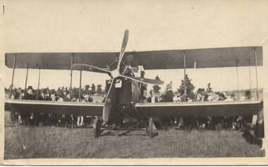
Photograph, Air flights, c 1920s
In the 1920s some joy flights took off in small biplanes from McMahon's dairy property in Sunbury.Many different social activities took place in Sunbury when the town's population was less than 2000 despite its distance from Melbourne. The joy flights are one example of these activities.A sepia photograph with a cream border of the front view of a small biplane in a paddock with people standing behind it. joy flights -
University of Melbourne, Burnley Campus Archives
Photograph - Black and white print, 2/2, 1942
Cacti collection. Looking towards Bull Paddock with Pavilion and Administration Building in the background. September 1942. cacti collection, bull paddock, pavilion, administration building, e. m. gibson collection -
Federation University Art Collection
Bookplate, 'Ex Libris Kevin'
After a quiet period, interest in bookplates in Australia began to increase in the early 1970s, Entrepreneurial art and book collectors such as Edwin Jewell and others commissioned multiple Bookplate designs from a range of well known fine artists. At a 1997 meeting in Melbourne of the Ephemera Society of Australia Edwin Jewell and others announced the formation of the Australian Bookplate Society. The society was instrumental in promoting the art of the bookplate through establishment of the Australian Bookplate Design competition.An aerial view depicts a red-roofed house and a tractor amongst green, yellow and brown paddocks.Kevin Marriot on backbookplate, printmaking, australian bookplate design award -
 Kew Historical Society Inc
Photograph - Flooding of the Yarra Valley at Kew East, 1974
Flooding of the Yarra Valley, including that section of the Yarra bordering Kew and Kew East in the north and west of the municipality, was a regular occurrence. Extreme flood events of the Yarra River are recorded to have occurred in 1891, 1901, 1916, 1923 and 1934. The Municipality of Kew's response to these floods was to enact planning decisions restricting residential development in flood prone areas following the floods of 1916, 1921 and 1934. While floods continued after the development of the Upper Yarra Reservoir (construction 1948-57), the regularity and extent of these inundations diminished. During the nineteenth century, the land abutting the south side of the Yarra in Kew was devoted to dairy farming. In the twentieth century, before and after the construction of the Eastern Freeway, much of this low-lying area was used as golf courses and public parks.Late example of the capacity of the Yarra Valley at Kew to flood, even though drainage works and the Upper Yarra Reservoir had reduced their regularity.Original black and white print photograph of the low-lying land at East Kew under floodwater on 16 May 1974. The vantage point of the photographer is Lister Street. In the photo, the fences of the Kilby Farm can be seen. Flooding was caused by overflowing water in Glass' Creek and the River Yarra. Annotation verso: "Hay's Paddock op No.30 Lister Street / 16 May 1974 11.50am / R.L. 46.04"hays paddock, floods, yarra river, glass' creek, lister street -
 Lakes Entrance Historical Society
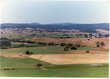
Photograph - Mossiface Flats, Tambo Shire, 1994
Also second identical copyColour photograph of the Mossiface Flats, near Bruthen, shows paddocks of the rich river flats, timbered foothills in the distance, with mountain range behind. Some paddocks have been mown for grass hay. Farm buildings in foreground and background. Dam in foreground. Bruthen Victoriaanimals, agriculture, vegetation, topography -
 Orbost & District Historical Society
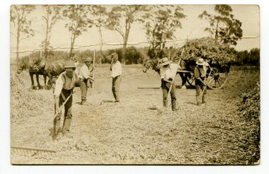
black and white photograph, first half 20th century
The men in this photograph are harvesting dry bean plants. They have been threshed with flails and raked. the dry straw is tossed off and the dry beans are collected to be hand sorted.This item is associated with the seed bean industry which was a major industry in the Orbost district for the first half of the 20th century.A black / white photograph / postcard of five men raking hay in a paddock with two horses and carts in the background.on back - "Orbost, M. Gilbert"agriculture-beans orbost-bean-seeds