Showing 314 items matching "parks and environment"
-
 St Kilda Historical Society
Photograph - Photo map, 11/01/1968
One of a series of photo-maps produced for the Department of Crown Lands and Survey (1857-1983). For correlation with a current map, and access to other historical photo maps of Victoria, see the Historic Photo-Maps Index published by the Department of Environment, Land, Water and Planning at https://services.land.vic.gov.au/DELWPmaps/historical-photomaps/Black and white aerial photographVic 2132 State Aerial Survey Melbourne 1968 Proj Run 27E 11.1.68 5100 ASL 65caulfield north, caulfield park, armadale, malvern, 1968 -
 St Kilda Historical Society
Photograph - Photo map, 11/01/1968
One of a series of photo-maps produced for the Department of Crown Lands and Survey (1857-1983). For correlation with a current map, and access to other historical photo maps of Victoria, see the Historic Photo-Maps Index published by the Department of Environment, Land, Water and Planning at https://services.land.vic.gov.au/DELWPmaps/historical-photomaps/Black and white aerial photographVic 2132 State Aerial Survey Melbourne 1968 Proj Run 27E 11.1.68 5100 ASL 67st kilda east, st kilda cemetery, caulfield north, alma park, balaclava, armadale, 1968 -
 St Kilda Historical Society
Photograph - Photo map, 13/01/1968
One of a series of photo-maps produced for the Department of Crown Lands and Survey (1857-1983). For correlation with a current map, and access to other historical photo maps of Victoria, see the Historic Photo-Maps Index published by the Department of Environment, Land, Water and Planning at https://services.land.vic.gov.au/DELWPmaps/historical-photomaps/Black and white aerial photograph2138 State Aerial Survey Melbourne 1968 Proj. Run 26 13.1.68 5100 ASL 203st kilda west, albert park, fawkner park, south yarra, prahran, windsor, 1968 -
 St Kilda Historical Society
Photograph - Photo map, 11/01/1968
One of a series of photo-maps produced for the Department of Crown Lands and Survey (1857-1983). For correlation with a current map, and access to other historical photo maps of Victoria, see the Historic Photo-Maps Index published by the Department of Environment, Land, Water and Planning at https://services.land.vic.gov.au/DELWPmaps/historical-photomaps/Black and white aerial photographVic 2132 State Aerial Survey Melbourne 1968 Proj. Run 27E 11.1.68 5100 ASL 69st kilda, albert park, st kilda east, st kilda beach, alma park, windsor, prahran, 1968 -
 St Kilda Historical Society
Photograph - Photo map, 11/01/1968
One of a series of photo-maps produced for the Department of Crown Lands and Survey (1857-1983). For correlation with a current map, and access to other historical photo maps of Victoria, see the Historic Photo-Maps Index published by the Department of Environment, Land, Water and Planning at https://services.land.vic.gov.au/DELWPmaps/historical-photomaps/Black and white aerial photographVic 2132 State Aerial Survey Melbourne 1968 Proj. Run 29E 11.1.68 5100 ASL 194elwood, elwood beach, elwood park, elsternwick park, ripponlea, elwood canal, balaclava, st kilda, 1968 -
 St Kilda Historical Society
Photograph - Photo map, 11/01/1968
One of a series of photo-maps produced for the Department of Crown Lands and Survey (1857-1983). For correlation with a current map, and access to other historical photo maps of Victoria, see the Historic Photo-Maps Index published by the Department of Environment, Land, Water and Planning at https://services.land.vic.gov.au/DELWPmaps/historical-photomaps/Black and white aerial photographVic 2132 State Aerial Survey Melbourne 1968 Proj. Run 27E 11.1.68 5100 ASLst kilda, st kilda west, st kilda pier, catani gardens, st kilda beach, albert park, 1968 -
 St Kilda Historical Society
Photograph - Photo map, 11/01/1968
One of a series of photo-maps produced for the Department of Crown Lands and Survey (1857-1983). For correlation with a current map, and access to other historical photo maps of Victoria, see the Historic Photo-Maps Index published by the Department of Environment, Land, Water and Planning at https://services.land.vic.gov.au/DELWPmaps/historical-photomaps/Black and white aerial photographVic 2132 State Aerial Survey Melbourne 1968 Proj. Run 29E 11.1.68 5100 ASL 196elwood, elwood park, elwood canal, elwood beach, st kilda marina, mc moran reserve, point ormond, 1968 -
 St Kilda Historical Society
Photograph - Photo map, Department of Crown Lands and Survey (1857-1983), 22/01/1970
One of a series of photo-maps produced for the Department of Crown Lands and Survey (1857-1983). For correlation with a current map, and access to other historical photo maps of Victoria, see the Historic Photo-Maps Index published by the Department of Environment, Land, Water and Planning at https://services.land.vic.gov.au/DELWPmaps/historical-photomaps/Black and white aerial photographVic 2358 Department of Crown Lands and Survey Victoria,.© Melbourne 1970 Project Run 42E 22.1.70 5,100 ASL 77st kilda, st kilda east, st kilda marina, elwood, elwood canal, elsternwick park, point ormond, balaclava, mc moran reserve, ripponlea, st kilda botanical gardens, peanut farm, 1970 -
 St Kilda Historical Society
Photograph - Photo map, Department of Crown Lands and Survey, 22/01/1970
One of a series of photo-maps produced for the Department of Crown Lands and Survey (1857-1983). For correlation with a current map, and access to other historical photo maps of Victoria, see the Historic Photo-Maps Index published by the Department of Environment, Land, Water and Planning at https://services.land.vic.gov.au/DELWPmaps/historical-photomaps/Black and white aerial photographVic 2358 Department of Crown Lands and Survey Victoria,.© Melbourne 1970 Project Run 43E 22.1.70 5,100 ASL 208elwood, elwood beach, point ormond, elwood park, elwood canal, mc moran reserve, 1970 -
 St Kilda Historical Society
Photograph - Photo map, Department of Crown Lands and Survey, 22/01/1970
One of a series of photo-maps produced for the Department of Crown Lands and Survey (1857-1983). For correlation with a current map, and access to other historical photo maps of Victoria, see the Historic Photo-Maps Index published by the Department of Environment, Land, Water and Planning at https://services.land.vic.gov.au/DELWPmaps/historical-photomaps/Black and white aerial photographCONTROLLED Vic 2358 Department of Crown Lands and Survey Victoria,.© Melbourne 1970 Project Run 41E 22.1.70 5,100 ASL 66st kilda, albert park, st kilda west, catani gardens, st kilda botanical gardens, st kilda pier, st kilda beach, 1970 -
 St Kilda Historical Society
Photograph - Photo map, 14/12/1963
One of a series of photo-maps produced for the Department of Crown Lands and Survey (1857-1983). For correlation with a current map, and access to other historical photo maps of Victoria, see the Historic Photo-Maps Index published by the Department of Environment, Land, Water and Planning at https://services.land.vic.gov.au/DELWPmaps/historical-photomaps/Black and white aerial photographVic 1807 Melbourne 1963 Project Run 16 14.12.1963 Lens 205 152.70 M/M 5.150 177st kilda, st kilda pier, catani gardens, middle park, albert park, st kilda west, st kilda beach, 1963 -
 St Kilda Historical Society
Photograph - Photo map, Department of Crown Lands and Survey, 22/01/1970
One of a series of photo-maps produced for the Department of Crown Lands and Survey (1857-1983). For correlation with a current map, and access to other historical photo maps of Victoria, see the Historic Photo-Maps Index published by the Department of Environment, Land, Water and Planning at https://services.land.vic.gov.au/DELWPmaps/historical-photomaps/Black and white aerial photographVic 2358 Department of Crown Lands and Survey Victoria,.© Melbourne 1970 Project Run 41E 22.1.70 5,100 ASL 64st kilda, st kilda cemetery, balaclava, st kilda east, windsor, caulfield north, alma park, 1970 -
 St Kilda Historical Society
Photograph - Photo map, Department of Crown Lands and Survey, 08/01/1970
One of a series of photo-maps produced for the Department of Crown Lands and Survey (1857-1983). For correlation with a current map, and access to other historical photo maps of Victoria, see the Historic Photo-Maps Index published by the Department of Environment, Land, Water and Planning at https://services.land.vic.gov.au/DELWPmaps/historical-photomaps/Black and white arial photographVic 2345 Department of Crown Lands and Survey Victoria,.© Melbourne 1970 Project Run 40 8.1.70 5,100 ASL 77albert park, fawkner park, south yarra, middle park, prahran, windsor, st kilda, st kilda west, 1970 -
 St Kilda Historical Society
Photograph - Photo map, 22/01/1970
One of a series of photo-maps produced for the Department of Crown Lands and Survey (1857-1983). For correlation with a current map, and access to other historical photo maps of Victoria, see the Historic Photo-Maps Index published by the Department of Environment, Land, Water and Planning at https://services.land.vic.gov.au/DELWPmaps/historical-photomaps/Black and white aerial photographVic 2358 Department of Crown Lands and Survey Victoria,.© Melbourne 1970 Project Run 43E 22.1.70 5,100 ASL 206elwood, elsternwick, elsternwick park, 1970 -
 Sunshine and District Historical Society Incorporated
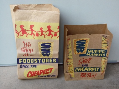
Brown Paper Grocery Bags
These type of brown paper grocery bags were commonly supplied by SSW Supermarkets, and also by other Supermarkets. The customers generally packed their own grocery purchases into the bags, while the checkout people were engaged in the time consuming process of accurately entering by hand, the price of each item into the cash registers. One local SSW Supermarket was situated on Sun Crescent in Sunshine. The introduction of stronger plastic film grocery bags and barcode scanning saved time, and the checkout person took over the role of packing the grocery purchases. In recent times customers who use the self check out terminals have again assumed the role of packing their own groceries. The environment polluting plastic bags however still remain, unless the customers bring their own 'green' bags.These two brown paper grocery bags provide a historical reminder of how grocery purchases were taken home from Supermarkets in the not too distant past. It is likely that many of the younger generation have no idea of how the paper grocery bags looked like, or that they were once used instead of plastic bags.Two brown paper bags which were available for free in SSW Supermarkets, so that customers could pack their grocery purchases to be able to take them home. The bags have SSW advertising printed on them in red, yellow, and navy blue inks.Large Bag: We Shop at .... SSW FOODSTORES STILL THE CHEAPEST DAY IN, DAY OUT! Smaller Bag: SSW SUPERMARKETS Still THE CHEAPEST DAY IN .... DAY OUT!brown paper grocery bag, ssw supermarket, food, grocery purchases, groceries. -
 Nillumbik Shire Council
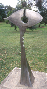
Public Art: Ernst FRIES (b.1934 Wurzburg, Germany - arrived 1959 Aus), Ernst Fries, Surveyor of Suburban Environs, Location: Alistair Knox Park, Main Road, Eltham, 1991
'Surveyor of Suburban Environs' was one of the acquisitions from the 1991 Eltham Art Awards (now known as the Nillumbik Prize - and formally the Nillumbik Art Awards). This was the first piece acquired from this award which was suitable for a public space. Nillumbik is referred to as the "Green Wedge" and the sculpture "Surveyor of Suburban Environs" suggests a watchful observer of the surrounding landscape. The sculpture's central motif represents an eye held up on a pedestal by a tail. Its form has been likened to the Eye of Horus, an ancient Egyptian symbol of protection, royal power and good health personified in the goddess Wadjet or 'green one'. This likeness would suggest that the observer or surveyor has a divine status and spiritual connection to its environment. Polished stainless steel sculpture comprising an eye reminiscent of ancient egyptian hieroglyphics, which is held up with a tappered and jaggered tail like pedestal. Concrete base. N/Apublic art, fries, spiritual, eye, stainless steel, goddess, surveyor, sculpture, environment -
 Whitehorse Historical Society Inc.
Book - Report, Changing attitudes to conservation and the environment reflected in the sites of Antonio Park and Yarran Dheran, 1997
A carefully documented essay on the history of Antonio Park and Yarran Dheran as examples of changes in public attitude to conservation.A carefully documented essay on the history of Antonio Park and Yarran Dheran as examples of changes in public attitude to conservation. References are made to the Aboriginal uses of the land, the roles of the Schwerkolt and Antonio families, the Nunawading City Council and the establishment of Antonio Park Primary School. The importance of appropriate botanic species is stressed. 14 pages. Includes bibliography.A carefully documented essay on the history of Antonio Park and Yarran Dheran as examples of changes in public attitude to conservation. antonio park, mitcham, yarran dheran, antonio family, mullum mullum creek, environment -
 Whitehorse Historical Society Inc.
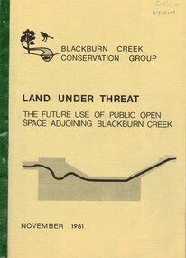
Document, Land under threat, 1981
'Land under threat: the future use of public open space adjoining Blackburn Creek' by Blackburn Creek Conservation Group, November 1981.'Land under threat: the future use of public open space adjoining Blackburn Creek' by Blackburn Creek Conservation Group, November 1981. Includes detailed descriptions, plans, bird lists, correspondence.'Land under threat: the future use of public open space adjoining Blackburn Creek' by Blackburn Creek Conservation Group, November 1981.blackburn creek, parks and reserves, kalang park, furness park, environment, blackburn creek conservation group, blacks walk, blackburn creeklands, melbourne and metropolitan board of works, city of nunawading, burgess, graham -
 Whitehorse Historical Society Inc.
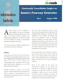
Pamphlet, Eastern Freeway Extension, 1/08/1998 12:00:00 AM
Information bulletin giving history map showing features of extension,Information bulletin giving history map showing features of extension, members of liaison group established for consultation.Information bulletin giving history map showing features of extension,freeways, springvale road, nunawading, mitcham road, mitcham, park road, mullum mullum creek, deep creek road, loughnan road, ringwood, harrison street, acacia court, maroondah highway, city of whitehorse, city of manningham, city of maroondah, melbourne water, victoria. department of natural resources and environment, environment protection authority, victoria, vicroads, eastern freeway -
 Whitehorse Historical Society Inc.
Book - Report, Koonung - Mullum Forestway, c1975
The Koonung-Mullum Freeway : a plan for action. A Report prepared for the Mullum Valley Freeway Action Group and Koonung Valley Action Group, under a grant from the Department of Environment by Ronald Champion Conservation Planning Environment Consultants and Paul Thompson, Rob Paul Landscapes ca1975mullum valley freeway action group, koonung valley action group, champion, randall, thompson, paul, rob paul landscapes, victoria. department of the environment, mullum mullum creek, koonung creek, eastern freeway, forest conservation, parks and reserves -
 Whitehorse Historical Society Inc.
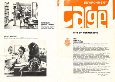
Pamphlet, Environment target, ca 1972
Mayor's challenge to citizens to support activities and organizations in which Council is involved including scouts, reserves, pre-school centres, meals on wheels, libraries and infant welfare centres.environment, city of nunawading, gawler, david, antonio park, mitcham, schwerkolt cottage, blackburn lake sanctuary, yarran dheran, blackburn branch library, warekila pre-school centre -
 Whitehorse Historical Society Inc.
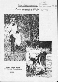
Pamphlet, Cootamundra Walk, 1992
News from the Cootamundra Walk Advisory Committee describing work being done with the help of various organisations.parks and reserves, williams road, blackburn, goodwin street, cootamundra walk, blackburn high school environment awareness group, skillshare, nunawading, greening australia, burnley agricultural college, city of nunawading, nunawading indigenous plants project -
 Whitehorse Historical Society Inc.
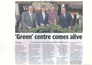
Article, 'Green' Centre Comes Alive, 09/12/2019
Burwood Brickworks has been officially opened as a living building.Burwood Brickworks has been officially opened as a living building with a 2000 sq. m. rooftop farm and 250 trees to cover the northern side of the centre & fruit trees lining each row of the car park.Burwood Brickworks has been officially opened as a living building. brickworks, shopping centre, environment, trees -
 Whitehorse Historical Society Inc.
Document - Pamphlet, Nunawading - A bush city, ca 1966
Booklet from Blackburn and District Tree Preservation Society List of parks and reserves in Nunawading.trees, blackburn and district tree preservation society, environment -
 Whitehorse Historical Society Inc.
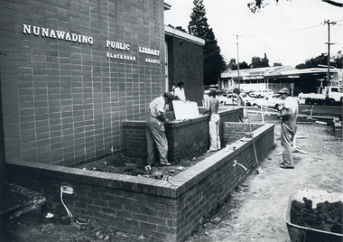
Photograph, Landscaping - Blackburn Library
Black and white photograph of workmen finishing the garden area of the Blackburn Branch of the Nunawading Public Library in 1977-78 prior to the landscaping by Parks and Gardens staff.city of nunawading - gardens and environment, blackburn branch library -
 Robin Boyd Foundation
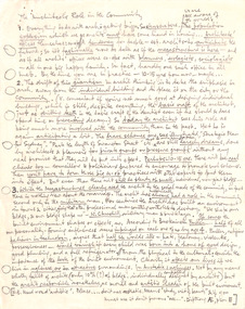
Document - Manuscript, Robin Boyd, The Architect's Role in the Community
Appears to be a handwritten speech where Boyd discusses the architect's role in the community and describes architecture as "getting bigger". Boyd describes the shift in architect's thinking as moving away from the individual building to the city or the community. He argues that architecture inherently affects our lives if we live in ugliness, or in attractive surroundings and that the architect is responsible as moral and artistic leaders of the built environment.Handwritten (pencil), quarto, 1 pageNumbered paragraphs. Underlined phrases. Circles in margin.w.churchill, buckminster fuller, strategic plan for sydney, megastructure, community, park the length of swanston street, japan -
Kew Historical Society Inc
Journal, Kewriosity : September 1989
New Mayoral team looks to the future [Cr Michael Montalto, Cr Daryl Oldaker] / p1. Maternal and Child Health review / p1. Dates for September / p2. Head Lice Infection hits local Schools / p2. Commentary [Council Mission Statement] / Cr Michael Montalto / p3. Meet the Mayoral team [Cr Montalto & Cr Oldaker profiles] / p3. Kew Hawthorn Tenancy Week / p3. Notices / p4. Kew Neighbourhood Watch [meetings] / p4. Area 6 Traffic [Management Committee] / p4. Learning for leisure [Kew Recreation Centre] / p4. School holiday programs / p4. Tutors in training [Adult literacy] / p4. Kew Band report / p4. Children's Week / p5. Crackdown on dogs / p5. Aqua friends / p5. Kew's young concerned about health / p5. Rowing Four wins gold / p5. Hard of hearing seminar / p6. Government funding for Community Environment Groups / p6. Keep Kew Green [1990 Kew Festival] / p6. Open days for Kew's kindergartens / p6. Garden dedicated in ex-Principal's honour [Bicentennial Garden, Kew East Primary School, Graeme Lindsay] / p7. Deliverers wanted / p7. Awards for Kew Lions [and Lionesses] / p7. Bus volunteers [Kew Community Bus] / p7. Council taking a look at Kew's open spaces / p7. Letters to the editor / p8. Boroondara Bushwalkers [pollution, Yarra Bend Park] / p8. [Deepdene Uniting] Cricket Club recruiting new players / p8. Footy news [Kew Football Club] / p8. Keeping you informed [Consumer Affairs Kit] / p8.Kewriosity was a local newsletter combining Kew Council and community news. It was published between November 1983 and June 1994, replacing an earlier Kewriosity [broad] Sheet (1979-84). In producing Kewriosity, Council aimed to provide a range of interesting and informative articles covering its deliberations and decision making, together with items of general interest and importance to the Kew community and information not generally available through daily media outlets.non-fictionNew Mayoral team looks to the future [Cr Michael Montalto, Cr Daryl Oldaker] / p1. Maternal and Child Health review / p1. Dates for September / p2. Head Lice Infection hits local Schools / p2. Commentary [Council Mission Statement] / Cr Michael Montalto / p3. Meet the Mayoral team [Cr Montalto & Cr Oldaker profiles] / p3. Kew Hawthorn Tenancy Week / p3. Notices / p4. Kew Neighbourhood Watch [meetings] / p4. Area 6 Traffic [Management Committee] / p4. Learning for leisure [Kew Recreation Centre] / p4. School holiday programs / p4. Tutors in training [Adult literacy] / p4. Kew Band report / p4. Children's Week / p5. Crackdown on dogs / p5. Aqua friends / p5. Kew's young concerned about health / p5. Rowing Four wins gold / p5. Hard of hearing seminar / p6. Government funding for Community Environment Groups / p6. Keep Kew Green [1990 Kew Festival] / p6. Open days for Kew's kindergartens / p6. Garden dedicated in ex-Principal's honour [Bicentennial Garden, Kew East Primary School, Graeme Lindsay] / p7. Deliverers wanted / p7. Awards for Kew Lions [and Lionesses] / p7. Bus volunteers [Kew Community Bus] / p7. Council taking a look at Kew's open spaces / p7. Letters to the editor / p8. Boroondara Bushwalkers [pollution, Yarra Bend Park] / p8. [Deepdene Uniting] Cricket Club recruiting new players / p8. Footy news [Kew Football Club] / p8. Keeping you informed [Consumer Affairs Kit] / p8. publications -- city of kew (vic.), kewriosity, council newsletters, community newsletters -
 Kew Historical Society Inc
Plan, Melbourne & Metropolitan Board of Works : Borough of Kew : Detail Plan No.1571, 1904
The Melbourne and Metropolitan Board of Works (MMBW) plans were produced from the 1890s to the 1950s. They were crucial to the design and development of Melbourne's sewerage and drainage system. The plans, at a scale of 40 feet to 1 inch (1:480), provide a detailed historical record of Melbourne streetscapes and environmental features. Each plan covers one or two street blocks (roughly six streets), showing details of buildings, including garden layouts and ownership boundaries, and features such as laneways, drains, bridges, parks, municipal boundaries and other prominent landmarks as they existed at the time each plan was produced. (Source: State Library of Victoria)This plan forms part of a large group of MMBW plans and maps that was donated to the Society by the Mr Poulter, City Engineer of the City of Kew in 1989. Within this collection, thirty-five hand-coloured plans, backed with linen, are of statewide significance as they include annotations that provide details of construction materials used in buildings in the first decade of the 20th century as well as additional information about land ownership and usage. The copies in the Public Record Office Victoria and the State Library of Victoria are monochrome versions which do not denote building materials so that the maps in this collection are invaluable and unique tools for researchers and heritage consultants. A number of the plans are not held in the collection of the State Library of Victoria so they have the additional attribute of rarity.Original survey plan, issued by the MMBW to a contractor with responsibility for constructing sewers in the area identified on the plan within the Borough of Kew. The plan was at some stage hand-coloured, possibly by the contractor, but more likely by officers working in the Engineering Department of the Borough and later Town, then City of Kew. The hand-coloured sections of buildings on the plan were used to denote masonry or brick constructions (pink), weatherboard constructions (yellow), and public buildings (grey). This plan is the other half of Plan No.1571 representing the constructions to the west of Wellington Street before and in 1903/4. This plan represents the built environment in Edgevale Road, Wellington Street, Atkins Street, Annadale Street, Mortimer Street, and Cotham Road. Whereas there are smaller allotments and more modest housing stock facing Edgevale Road, larger blocks and more substantial houses are represented facing Cotham Road.melbourne and metropolitan board of works, detail plans, mmbw 1571, cartography -
 Kew Historical Society Inc
Plan, Melbourne & Metropolitan Board of Works : Borough of Kew : Detail Plan No.1572, 1905
The Melbourne and Metropolitan Board of Works (MMBW) plans were produced from the 1890s to the 1950s. They were crucial to the design and development of Melbourne's sewerage and drainage system. The plans, at a scale of 40 feet to 1 inch (1:480), provide a detailed historical record of Melbourne streetscapes and environmental features. Each plan covers one or two street blocks (roughly six streets), showing details of buildings, including garden layouts and ownership boundaries, and features such as laneways, drains, bridges, parks, municipal boundaries and other prominent landmarks as they existed at the time each plan was produced. (Source: State Library of Victoria)This plan forms part of a large group of MMBW plans and maps that was donated to the Society by the Mr Poulter, City Engineer of the City of Kew in 1989. Within this collection, thirty-five hand-coloured plans, backed with linen, are of statewide significance as they include annotations that provide details of construction materials used in buildings in the first decade of the 20th century as well as additional information about land ownership and usage. The copies in the Public Record Office Victoria and the State Library of Victoria are monochrome versions which do not denote building materials so that the maps in this collection are invaluable and unique tools for researchers and heritage consultants. A number of the plans are not held in the collection of the State Library of Victoria so they have the additional attribute of rarity.Original survey plan, issued by the MMBW to a contractor with responsibility for constructing sewers in the area identified on the plan within the Borough of Kew. The plan was at some stage hand-coloured, possibly by the contractor, but more likely by officers working in the Engineering Department of the Borough and later Town, then City of Kew. The hand-coloured sections of buildings on the plan were used to denote masonry or brick constructions (pink), weatherboard constructions (yellow), and public buildings (grey). Plan No. 1572 represents the built environment bordered by Barkers Road, Wrixon Street, Edgevale Road and Fitzwilliam Street. Other streets identified on the plan include Stansell Street. Plan 1572 shows that by 1903-05, there was only patchy development in this area of Kew, mainly on Edgevale Road and Fitzwilliam Street. Only two named houses are identified: the quaintly named ‘Tweed Cottage’, and ‘Mendip’. The earliest reference to Treed Cottage in Australian newspapers is to the death of Walter Thompson, aged 74 who was a resident there in 1885. His youngest daughter was to die there in 1908. Mendip to the north of Tweed Cottage was owned by Henry Thompson; he was to die in 1901; his wife in 1932. At this period of time, Malin Street and Clivedon Court did not extend to Barkers Road.melbourne and metropolitan board of works, detail plans, mmbw 1572, cartography -
 Kew Historical Society Inc
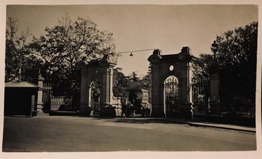
Photograph - Gates, Kew Lunatic Asylum, Henry Beater Christian, 1920s
Henry Christian (c.1809-91), the grandfather of the photographer, was one of the first settlers in Kew. He arrived in Victoria with his wife Agnes and son Orlando in 1855 on the Gypsy Queen. He established a rope-making business in Bulleen Road by 1858 but was declared insolvent two years later. In his final years, he was celebrated as one of the oldest living settlers of the district. His son, Orlando Henry Beater Christian (c.1853-1930) became a member of the Hawthorn Band and a foundation member of the Willsmere Swimming Club. Orlando and his wife Elizabeth had four children of which Henry Beater Christian (1886-1962) was the eldest.An item from an outstanding and diverse photographic collection, assembled by members of the Christian family of Pakington Street, Kew, comprising professional and amateur photography, depicting individuals, natural and settled environments and the interactions between these worlds. Many of the photographs vividly capture the worlds of three generations of men - Henry Christian, his son Orlando Henry Beater Christian, and his grandson of Henry Christian. The most important photographer was the youngest, Henry Christian, who was a keen explorer, not just of his immediate environment but also of the Victorian wilderness. His major opus is contained in two albums in which he records, sometimes in majestic detail and on other occasions the intimate features of the natural world. His photographic travels during the 1920s, often in solitary ramblings but on other occasions with companions, recall the heroic landscape photography of an earlier era, pioneered by Nicholas Caire. In addition to their aesthetic value, the albums are historically significant records within the State of Victoria, of what is now a distant point in time, and of places that have become radically altered through human intervention.Sepia photograph of the entrance gates to the Kew Asylum. Located in Princess Street, these gates were relocated to Victoria Park in the 1930s/40s. There is a shelter to the left of the gates. A horse-drawn covered carriage is exiting through the gates. An electric light is hung from a metal bar in the centre of the gates. The two-storey gate house on the right of the gates is outside the view of the photograph.kew lunatic asylum, kew lunatic asylum -- gates, henry beater christian, christian-washfold collection