Showing 339 items matching "planting plans"
-
 University of Melbourne, Burnley Campus Archives
Plan - Planting Design, Cul-de-sac Planting Design, Nov 2020
... Boulevard Richmond melbourne john rayner garden plan plant list ...john rayner, garden plan, plant list -
University of Melbourne, Burnley Campus Archives
Plan - Planting Design, Vireya Rhododendrons, 2015
... Handdrawn plan and list of plants.... Boulevard Richmond melbourne vireya rhododendrons garden plan plant ...vireya rhododendrons, garden plan, plant list -
University of Melbourne, Burnley Campus Archives
Plan - Planting Design, Gibson North Island Bed
... Boulevard Richmond melbourne emily gibson plant list garden plan ...emily gibson, plant list, garden plan -
![Plan, University of Melbourne Burnley Campus Institute of Land and Food Resources Formerly known as the Royal Horticultural Gardens Burnley [sic], 2001](/media/collectors/52f2d90c9821f4163875a333/items/6145823c174069677c22f6e6/item-media/65ef8feeb2201fddf6999498/item-fit-380x285.jpg) University of Melbourne, Burnley Campus Archives
University of Melbourne, Burnley Campus ArchivesPlan, University of Melbourne Burnley Campus Institute of Land and Food Resources Formerly known as the Royal Horticultural Gardens Burnley [sic], 2001
... with land elevations. 3. Plan with trees and plants. Colour.... Plan with trees and plants. Colour and black and white aerial ...site plan, buildings, planrs -
 University of Melbourne, Burnley Campus Archives
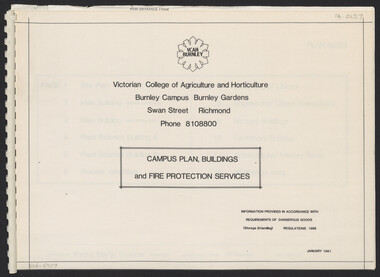
Plan, Campus Plan, Buildings and Fire Protection Services
... Boulevard Richmond melbourne Site plan buildings administration ...site plan, buildings, administration building, plant science laboratories, quad, library, student amenities building, engineering, urban horticulture, nursery -
Friends of Ballarat Botanical Gardens History Group
Work on paper - Simon Grant: Part 5 of the Explorers, David Douglas in the Land of Giants, Published 1998
David Douglas (1799-1834) journeyed to the Pacific North-West as well as to other parts of the New World looking for new species of plants. The Royal Horticultural Society of London hoped to introduce new and exciting plants to its gardens.After Douglas's explorations in the New World, hundreds of new species became available. As a result flower beds and theme gardens with new exotic specimens and aboreta became fashionable. This information gives some perspective on the planning and development of the Ballarat Botanical Gardens.2 pages of print in columns. There is a black and white photograph of David Douglas halfway down the page on the lefthand side of p.1. On p.2 there is a black and white photograph of the Douglas Fir on the lefthand side of the page and lower down a photograph of Lupinus polyphyllus.none.john garner, doctor john garner, ballarat botanic gardens, friends of ballarat botanical gardens, david douglas, royal horticultural society, kew gardens, douglas fir, sitka spruce, radiata pine, john claudius loudon, joseph banks, john garner collection, gardens, ballarat -
Friends of Ballarat Botanical Gardens History Group
Work on paper - Differing Styles of Wardian Cases, The Transportation of Plants to Ballarat and Other Parts of the World, 27/2/2009
Wardian cases made it possible for plants and seeds to be transported long distances and to be in good condition on arrival.Without Wardian cases, it would have been impossible to plan and implement the Ballarat Botanical Gardens in the Gardenesque style that we see today.p.1 is headed "A Wardian Case" and is a little over 1/2 a page. p 2. is headed File: Wardian Cases and has pictures of 4 styles of wardian cases. p3. is entitled Wardian case and has a small picture on the lefthand side of a wardian case. p.4. has 1/2 a page of print and another small picture of a wardian case on the lefthand side of the page with References at the bottom of the page. Nonejohn garner, doctor john garner, ballarat botanical gardens, friends of ballarat botanical gardens, wardian cases, styles of wardian cases, thomas rooney, george longley, mr duthie, robert fortune, doctor nathaniel bagshaw ward, joseph dalton hooker, kelway and son somerset england, john garner collection, gardens, ballarat -
Friends of Ballarat Botanical Gardens History Group
Work on paper - Victoria Park Precinct, City of Ballarat, Notes on the Parkland in the Nineteenth Century, Unknown
... in history and plans for the planting of trees. John Garner Doctor ...This page gives information about Victoria Park essentially from 1884-1894.Some idea is given here of Victoria Park back in history and plans for the planting of trees.1 page headed Victoria Park with a rough sketch of the Parkland area. There is an unfinished sentence at the bottom of the page and no page to follow.Nonejohn garner, doctor john garner, weston bates, george longley, curator, ballarat botanical gardens, night soil, ballarat council parks and gardens committee, gum trees, pines, victoria park, history friends of ballarat botanical gardens, john garner collection, gardens, ballarat -
Tarnagulla History Archive
Photograph - Photograph: Company's Dam and Flour Mill, Tarnagulla, c. 1880 - 1920
Williams Family Collection. On the 20th December 1873 it was reported in the Tarnagulla Courier that arrangements were being made for the erection of a steam flour mill at Tarnagulla. Mr Bristol had purchased the necessary plant which would be erected with as little delay as possible. The site chosen was the premises occupied previously by Mr John Pierce, grocer and wine and spirit merchant, at the corner of King and Commercial Road. These premises were incorporated in the mill building. Suitable buildings for receiving and storing grain and flour had been erected already. On 10th January, 1874 an advertisement in the Courier called for tenders from masons, bricklayers and carpenters for the erection of a flour mill at Tarnagulla for H. C. Bristol, Esq. with all enquiries to be made from G. Minto, Engineer. In December 1881 the proprietors made a request to the Tarnagulla Borough Council for permission to lay pipes to the Municipal Dam, which was generally known as the Company's Dam, and to obtain water from the dam for milling purposes. This was granted. Steam was got up for the first time on 30th of March, 1882. A large quantity of wheat was stored ready for milling. Just prior to 29th of April 1882 the boiler at the mill burst, as the result of which two men, J. H. Smith and W. Hargreaves died and H. Joyce Bousfield, senior and junior, were seriously injured. The mill commenced operations on 13th June, 1882 with Mr W Fitzgerald as manager. The price offered for wheat was thirty-seven pence per bushell. It operated with grinding stones until considerable renovations were done in the early part of 1899 when new rollers and more up to date equipment installed. The mill was then known as the Tarnagulla Flour Mill Co., with Thos. Comrie as proprietor, Mr Fitzgerald was still manager, and Mr T. Leonard was the traveller. Much new equipment was put in and each of the three floors had different processes. The rollers were on the ground floor, the purifiers and elevators reel were on the second floor, plus the clean wheat bin directly over the Ganz rollers. On the top floor was the chop reel, bran reel, inter-elevator reels, brush machine cyclone sack hoist, dirty wheat shaker, clean wheat bin, dust rooms and also double damping rooms. A plant was also erected for the making of an improved quality of wheaten meal, for which purpose special machinery was procured and a pair of stones was left for grinding the meal. A complete plant for the crushing of oats etc was also erected. The driving power of the mill was supplied by a new engine complete with 16 inch cylinder, manufactured and erected by Bousfield & Co. of Eaglehawk. It was fitted with Pickering governors, connected with the cylinder was a super heater. The boiler was tested and all connections etc. overhauled, with much of it being completely renewed. There was a complete network of belts, spouts, elevators etc. all over the building, all conveniently placed. The plans etc for the new plant were drawn up by Mr J. Kilborn, manager of the firm of Bodington & Co., engineers and millwrights of Carlton, which supplied the whole of the machinery, excepting the engine. The work of erection was carried out by Mr Kilborn and his assistants to the entire satisfaction of Mr Comrie, who had gone to considerable expense to bring the mill to a completely up-todate machine, fitted with all of the most modern appliances available. An advertisement on May 6th, 1899 read: "Tarnagulla Flour Mill Co., Patent Roller Flour. Also their Digestive Wheaten Meal specially prepared for Porridge or Bread." In January 1901, 6000 bags of wheat were received weekly at the mill and it was a common sight to see the streets lined with wagons. In May 1902 the mill was lighted by gas and in July 1906 an application was made to the Tarnagulla Borough Council for permission to lay a tram track from the mill to the Railways Station. Council was agreeable to this provided suitable plans were submitted. In 1913, 15,000 bags of wheat were bought at three shillings and four pence per bushell. In January 1914 the mill was renovated. At this time 1500 bags of wheat were coming in daily, with 20,000 bags in storage. On 15th December, 1917 the mill was advertised for sale, to be sold on Friday, 21st December,.1917, on behalf of the Estate of the Late Thomas Comrie, who had died on 4th August, 1910. The Courier at that time recorded him as being responsible for the building of the mill and with being the sole proprietor. The mill was closed, apparently, for a short period. The Courier reported on 13th of September, 1918 that the mill had been sold to Mr O. Albert of Talbot and that it would re-open. An advertisement read: ALBERT. O. & SON, MILLERS. During 1920 the mill was closed and pulled down. It was later re-erected at Mildura where it operated for many years. (by Donald Clark)Monochrome photograph depicting view of Company's Dam and the flour mill in Tarnagulla. Handwritten on reverse: 'J. Caldwell and photographer's stamp 'C. Bock Photo Tarnagulla'.tarnagulla -
Tarnagulla History Archive
Postcard - Photographic postcard: Company's Dam and Flour Mill, Tarnagulla, c. 1880 - 1920
Williams Family Collection. On the 20th December 1873 it was reported in the Tarnagulla Courier that arrangements were being made for the erection of a steam flour mill at Tarnagulla. Mr Bristol had purchased the necessary plant which would be erected with as little delay as possible. The site chosen was the premises occupied previously by Mr John Pierce, grocer and wine and spirit merchant, at the corner of King and Commercial Road. These premises were incorporated in the mill building. Suitable buildings for receiving and storing grain and flour had been erected already. On 10th January, 1874 an advertisement in the Courier called for tenders from masons, bricklayers and carpenters for the erection of a flour mill at Tarnagulla for H. C. Bristol, Esq. with all enquiries to be made from G. Minto, Engineer. In December 1881 the proprietors made a request to the Tarnagulla Borough Council for permission to lay pipes to the Municipal Dam, which was generally known as the Company's Dam, and to obtain water from the dam for milling purposes. This was granted. Steam was got up for the first time on 30th of March, 1882. A large quantity of wheat was stored ready for milling. Just prior to 29th of April 1882 the boiler at the mill burst, as the result of which two men, J. H. Smith and W. Hargreaves died and H. Joyce Bousfield, senior and junior, were seriously injured. The mill commenced operations on 13th June, 1882 with Mr W Fitzgerald as manager. The price offered for wheat was thirty-seven pence per bushell. It operated with grinding stones until considerable renovations were done in the early part of 1899 when new rollers and more up to date equipment installed. The mill was then known as the Tarnagulla Flour Mill Co., with Thos. Comrie as proprietor, Mr Fitzgerald was still manager, and Mr T. Leonard was the traveller. Much new equipment was put in and each of the three floors had different processes. The rollers were on the ground floor, the purifiers and elevators reel were on the second floor, plus the clean wheat bin directly over the Ganz rollers. On the top floor was the chop reel, bran reel, inter-elevator reels, brush machine cyclone sack hoist, dirty wheat shaker, clean wheat bin, dust rooms and also double damping rooms. A plant was also erected for the making of an improved quality of wheaten meal, for which purpose special machinery was procured and a pair of stones was left for grinding the meal. A complete plant for the crushing of oats etc was also erected. The driving power of the mill was supplied by a new engine complete with 16 inch cylinder, manufactured and erected by Bousfield & Co. of Eaglehawk. It was fitted with Pickering governors, connected with the cylinder was a super heater. The boiler was tested and all connections etc. overhauled, with much of it being completely renewed. There was a complete network of belts, spouts, elevators etc. all over the building, all conveniently placed. The plans etc for the new plant were drawn up by Mr J. Kilborn, manager of the firm of Bodington & Co., engineers and millwrights of Carlton, which supplied the whole of the machinery, excepting the engine. The work of erection was carried out by Mr Kilborn and his assistants to the entire satisfaction of Mr Comrie, who had gone to considerable expense to bring the mill to a completely up-todate machine, fitted with all of the most modern appliances available. An advertisement on May 6th, 1899 read: "Tarnagulla Flour Mill Co., Patent Roller Flour. Also their Digestive Wheaten Meal specially prepared for Porridge or Bread." In January 1901, 6000 bags of wheat were received weekly at the mill and it was a common sight to see the streets lined with wagons. In May 1902 the mill was lighted by gas and in July 1906 an application was made to the Tarnagulla Borough Council for permission to lay a tram track from the mill to the Railways Station. Council was agreeable to this provided suitable plans were submitted. In 1913, 15,000 bags of wheat were bought at three shillings and four pence per bushell. In January 1914 the mill was renovated. At this time 1500 bags of wheat were coming in daily, with 20,000 bags in storage. On 15th December, 1917 the mill was advertised for sale, to be sold on Friday, 21st December,.1917, on behalf of the Estate of the Late Thomas Comrie, who had died on 4th August, 1910. The Courier at that time recorded him as being responsible for the building of the mill and with being the sole proprietor. The mill was closed, apparently, for a short period. The Courier reported on 13th of September, 1918 that the mill had been sold to Mr O. Albert of Talbot and that it would re-open. An advertisement read: ALBERT. O. & SON, MILLERS. During 1920 the mill was closed and pulled down. It was later re-erected at Mildura where it operated for many years. (by Donald Clark)Photographic postcard, front image depicting view of Company's Dam and the flour mill in Tarnagulla. Handwritten on reverse: 'A Merry Christmas and a Happy New Year, E. Bool' and photographer's stamp 'C. Bock Photo Tarnagulla'.tarnagulla -
 Wodonga & District Historical Society Inc
Book - Wilson Transformers - 50 Years of Achievement, R. S. McNaught, October 1983
This book gives an in-depth history of the development of the Wilsons Transformer Company Pty. Ltd. from its inception in 1933 until 1983. In this period over 74,000 transformers have been produced fromA bound volume of 365 pages outlining the development of the Wilson Transformer company, including illustrations, plans and photos. This book gives an in-depth history of the development of the Wilsons Transformer Company Pty. Ltd. from its inception in 1933 until 1983. In this period over 74,000 transformers have been produced from wilson electric transformer company - history, manufacturing industries wodonga, manufacturing australia -
 Wodonga & District Historical Society Inc
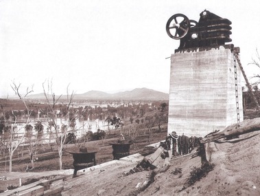
Album - Hume Reservoir Australia Album - Quarry plant being erected September 1921
This set of photos is from a leather bound album bearing the inscription "HUME RESERVOIR AUSTRALIA" plus 'The Rt. Hon. L. C. M. S. Amery, P. C., M .P.' all inscribed in gold. It was presented to The Rt. Hon. L. C. M. S. Amery, P. C., M. P, Secretary of State for Dominion Affairs on the occasion of his visit to the Hume Reservoir on 2nd November 1927. This album is of local and national significance as it documents the planning and development of the Hume Reservoir up to 1927. It was the largest water reservoir in the British Empire. The album records the pioneering engineering work that went into its construction.DEPARTMENT OF PUBLIC WORKS, N.S.W. RIVER MURRAY WATERS SCHEME. HUME RESERVOIR. 7. Quarry plant (New South Wales) being erected, September 1921. Murray Flats (in foreground) and Mitta Mitta Flats (beyond) flooded.hume reservoir australia, river murray waters scheme, quarry plant hume -
 Wodonga & District Historical Society Inc
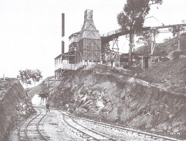
Album - Hume Reservoir Australia Album - Quarry plant completed, September 1922
This set of photos is from a leather bound album bearing the inscription "HUME RESERVOIR AUSTRALIA" plus 'The Rt. Hon. L. C. M. S. Amery, P. C., M .P.' all inscribed in gold. It was presented to The Rt. Hon. L. C. M. S. Amery, P. C., M. P, Secretary of State for Dominion Affairs on the occasion of his visit to the Hume Reservoir on 2nd November 1927. This album is of local and national significance as it documents the planning and development of the Hume Reservoir up to 1927. It was the largest water reservoir in the British Empire. The album records the pioneering engineering work that went into its construction.DEPARTMENT OF PUBLIC WORKS, N.S.W. RIVER MURRAY WATERS SCHEME. HUME RESERVOIR. 10. Quarry Plant (New South Wales) completed. September 1922. hume reservoir australia, river murray waters scheme, quarry plant -
 Federation University Historical Collection
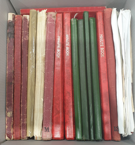
Book - Minute Book, Eureka Stockade Memorial Park Committee Minute Book
From the earliest minute book (1918) the committee of this organisation included women in decision making positions.Nine red hard covered books with the handwritten and computer generated minutes Eureka Stockade Memorial Park Committee . .1) Includes duties of officers, events, fundraising, payments, placing a tablet on the monument, list of members of the committee (139 names) .2) Eureka Widows and Orphans Fund, plan of proposed gardens, extension of the hall .3) Swimming pool improvement, proposed tramway extenson, electric light .7) Glasshouse .8) planting of trees .9) Eureka Stockade Centre .10) Financial Statements 11/2000-8/2003 Note, the minutes form 02/1932 to 1/1943 are not held within this collection, and were deemed to be missing when donated. gordon, eureka stockade, ballarat fine art gallery, lake penhalluriack, eureka caravan park, eureka hall, frank williams, eureka walk, dale kelly, john barnes, eureka s children, old colonists club, peter nicholson, paul wiliams, taite, ken clements, darren gamston, eureka playground, roly mckenzie, janet dore, len fox, pikeman s dog, f nielson, thomas keneally, al grasby, s jones, brian harvey, t bibby, eureka centre, eureka stockade centre, eureka stockade park committee, eureka stockade committee, e.g. pearce, bernardi, ratford, mckay, carey, mcgregor, ham, fallow, feary, jones, j.r. hams, j. davey, w. wye, r. quick, d. bernardi, eddy, gingell, micklejohn, w. mckay, w. carey, r. mcgregor, c. davies, sports programm, eureka stockade anniversary celebration, s. barker, d.c. mcgrath, m. baird, annual carnival, r. britnall, w. elsworth, g. williams, f. britnell, eurkea stockade improvement and progress association, w.j. corbett, crago, a. harrison, b. groves, s. leonard, h. parsons, e. plumridge, j. dynan, e.parsens, w.k. hood, walter a. shaw, f. pearce, a. pearce, vic carey, william carey, de gaafe, j.h. stanley, j. andrewartha, w. marshall, v.c. jones, m. byrne, caravan park, anan day, helen mckay, a. jones, n. jones, w. bromley, j. lamb, w. strange, p. hetherington, alex barnett\k. catios, l. eva, j. collins, j. shannon\, g. calions, l. o'brien, j.a. cook, w.g. fleet, g. lee, d. crooke, s. mckenzie, r. chittock, g. drake, s. romeo, p. williams, g. taite, j. webb, g. mckenzie, j. berriman, f. kennan, d. miller, d. scanlon, eureka luncheon, t. bibby, f. nielan, eureka dioramo -
 Ringwood and District Historical Society
Document - Folder, Land Sale - Monterey Park Subdivision, Warrandyte Road, Ringwood North, Vic. - 1981
Foolscap manilla folder containing double-sided flyer advertising residential subdivision development, including outline of local facilities and services, with locality map and layout of Monterey Park streets. Subdivision includes Parkwood High School, Tortice Drive, Heape Way, Appleberry Place, Stringybark Court, Conifer Court, Crawley Grove, Monterey Close (later Monterey Place), Lucy Place, Middlebrook Drive, Gahnia Close, Glanfield Court, Cone Close, Jull Parade, Pinus Close (later Pinetree Court), Radiata Close, Old Warrandyte Road, and entry from Warrandyte Road. Vendor - Jennings Industries Limited, 690 Springvale Road, Mulgrave, 3170, Phone 5618000. A4 enclosures with tables showing each allotment List Price, Builders Price, Cash Price and Terms Price. Information page headed "Form of Restrictive Covenant to be incorporated in Transfer" specific to Certificates of Title. Restrictive Covenant (summary): (Name/s) "... will not erect or construct or cause to be erected or constructed on the land hereby transferred (a) Any front boundary fence, other than a fence which does not exceed one metre in height unless the same is set back as least 1.5 metres from the front boundary and the same is effectively screened from that boundary by the planting of trees, shrubs or plants. (b) Any side boundary fence other than a fence which is set back at least 1.5 metres from the front boundary on which does not exceed 1 metre in height within 1.5 metres of the front boundary. (c) For a period of 5 years from the date hereof, any building on the said land unless and until the Plans and Specifications thereof have first been approved by the said Residential Developments Pty. Limited. (d) For a period of 2 years from the date hereof whilst the said land remains vacant any Signboard or Notice advertising the sale of the said lot or any other lot. These covenants shall appear on the Certificate of Title to issue for the said land and run with the land." -
University of Melbourne, Burnley Campus Archives
Plan, John Patrick Pty. Ltd, Banyule Gallery Tree Survey, 1988
Plan by John Patrick Pty. Ltd. For W.R. Johnston Trust. DRG No104/88701, November 1988. Drawn by P. Mills. Scale 1:200. Plants numbered but no legend.john patrick pty. ltd., w.r. johnston, banyule gallery, heidelberg -
 Falls Creek Historical Society
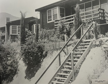
Photograph - Bogong Alpine Village Houses 1946
The images in the Bogong Village Collection were displayed in Bogong Jack’s Tavern for over 20 years and were donated to the Falls Creek Museum when the Tavern closed in 2021. In 1939, the State Electricity Commission of Victoria established a field headquarters at Bogong to house workers and their families for the Kiewa Hydroelectric Scheme which ran from the 1930s to the 1960s. The workmen's camp was originally started with tents and was called Junction Camp. By 1947, the village supported 300 workers and their families. It included 40 houses, a hostel for single staff, a post office, a police station, a medical centre, and a primary school. The staff hostel was known as Kiewa House. At the completion of the Scheme, in the 1960s, the village was opened to public/tourism use. In 1968 the Victorian Education Department acquired the camp buildings and four houses from the State Electricity Commission of Victoria to establish an Outdoor Education Centre which operated for over 50 years. The Kiewa Hydroelectric Scheme was privatized in the 1990s and sold to Southern Hydro, before being acquired by AGL in 2005. In 2023 the Grollo Group signed a 73 year sublease on Bogong Village and has plans for its redevelopment as a workers’ village.These images are significant because they capture the development of Bogong Village as an important element of the Kiewa Hydroelectric Scheme in Victoria.Two black and white images featuring houses in Bogong Village in January 1946. They are constructed of weatherboard, with brick chimneys and tin roofs. Timber steps lead up to the front door and a garden has been planted in front of the house.bogong alpine village, bogong high plains, bogong houses 1946 -
 Eltham District Historical Society Inc
Photograph - Digital Photograph, Marguerite Marshall, Wingrove Cottage, Main Road, Eltham, 8 June 2006
Wingrove Cottage built 1858-1859 of hand made bricks is historically significant for its long association with Charles Wingrove, a prominent figure in Victorian local government, as secretary to the Eltham District Road Board and Shire Council from 1858 to 1904, and Shire Engineer and Secretary to the Heidelberg Road Board. The cottage was used as the office of the Eltham District Road Board and Council for many years It is one of the Shire's oldest dwellings, and one of the few surviving 19th century buildings associated with early Eltham and located in the original Eltham Village Reserve. The symmetrical planting of a pair of Pencil Pines (not visible in photo) is also historically and aesthetically significant as characteristic of the early period of planting in the district and because they are a distinctive landscape feature. In October 2002 new owners demolished the outbuildings attached to the rear of the cottage. Community protest at the demolition resulted in Council issuing a Stop Work order. The owner was issued with a court order in September 2003 to develop a conservation management plan and restore the heritage listed property. The owner sold the property in 2005 to Cameron Construction in 2005 who undertook the restoration work. In 2007 a planning application to build two offices and seven dwellings at the rear of the property was ultimately rejected. The cottage is now the main office for Cameron Construction. Covered under Heritage Overlay, Nillumbik Planning Scheme. Published: Nillumbik Now and Then / Marguerite Marshall 2008; photographs Alan King with Marguerite Marshall.; p57 Wingrove Cottage on Main Road beside Eltham Primary School, is one of the Shire’s most important historical buildings and was central to local government for almost 50 years. The cottage was built in stages from 1858 to 1888 for Charles Symons Wingrove JP. He was the Eltham District Road Board’s first paid secretary and later the Shire Secretary when the board became the Eltham Shire Council. Wingrove held those positions, and that of engineer for a time, for 46 years. He was also one of the main figures in the Municipal Association of Victoria. As Eltham’s first paid municipal officer, Wingrove used one room in his 11 – (originally two) roomed home, as the office for the board then the council. Meetings were held there from the late 1850s (as well as at more central locations) until Wingrove’s retirement in 1904. The cottage is a rare example of a local government office occupying a Road Board /Shire Secretary’s purpose-designed house. The cottage is also significant because it is the oldest largely intact building from the original Eltham township reserve (south of Dalton Street).1 The township had its origins in the 1848 Nillumbik Parish Plan and was one of the state’s earliest township reserves. The rectangular house of handmade bricks, roofed with grey slate tiles and with a veranda encompassing three sides, is reminiscent of those in the central goldfields including Castlemaine. Its overhanging eaves and gables were unlike houses in Melbourne at the time. Wingrove, who was born in 1827, had been a gold digger and a road surveyor. Impossible to imagine in today’s world, Wingrove was also the Shire of Heidelberg’s secretary and engineer for part of the time that he was secretary in Eltham. Living next door to the primary school was a mixed blessing. Wingrove and his wife Katherine, who had ten children, sent their eight surviving children to the school. But they had occasional disputes with the school authorities when their cattle wandered into the schoolyard. Eltham showed Charles Wingrove its appreciation of his services by giving him two illuminated addresses, one after ten years and the other at retirement. Wingrove died in 1905 aged 76 and was buried in the St Katherine’s Church of England cemetery in St Helena. His grave is surrounded by those of family members including his wife, Katherine and two babies, Henry, 12 months and Isobella, 15 months, who died in the mid-1860s. Cottage ownership passed to his wife, then to daughter Caroline and then to daughter Bessie, a Melbourne University graduate and artist. During the Great Depression their brother Walter was the ratepayer. At one stage the Wingrove property extended to Metery Road and included a small creek. The family ran a small dairy and orchard, with associated farm buildings, which were later removed. In 1949 part of the property was compulsorily acquired by the Eltham Primary School, which infuriated owner Bessie Wingrove. She protested in a letter about this ‘monstrous act of unmitigated tyranny’.2 She was the last Wingrove to occupy the cottage and died in 1955. Wingrove descendants sold the house in 1974 and the property was subdivided. In the 1960s the Eltham Shire named the park opposite the cottage in Wingrove’s honour. The cottage has since had several owners including psychiatrist Dr Daniel Kahans, who practised there. In October 2002 late rear additions which had been substantially altered were demolished contrary to council planning controls. This caused a community outcry and resulted in legal proceedings against the owner. Fortunately the historical significance of the demolished section was not as great as the older front part of the building, which has been retained and was later restored.This collection of almost 130 photos about places and people within the Shire of Nillumbik, an urban and rural municipality in Melbourne's north, contributes to an understanding of the history of the Shire. Published in 2008 immediately prior to the Black Saturday bushfires of February 7, 2009, it documents sites that were impacted, and in some cases destroyed by the fires. It includes photographs taken especially for the publication, creating a unique time capsule representing the Shire in the early 21st century. It remains the most recent comprehenesive publication devoted to the Shire's history connecting local residents to the past. nillumbik now and then (marshall-king) collection, cameron construction, charles symons wingrove, eltham, eltham road district board, eltham shire council, main road, wingrove cottage -
 Eltham District Historical Society Inc
Photograph - Digital Photograph, Marguerite Marshall, Hawthorn hedges, Eltham-Yarra Glen Road, Kangaroo Ground, 3 October 2006
Hawthorn hedges are important reminders of Kangaroo Ground's Scottish heritage. They are Registered on the Victorian Heritage Register. They are "historically significant because the planting of hawthorn hedges reflects the adoption of Eurorpean farming techniques by the Kangaroo Ground population in the period following settlement and because the grid pattern of paddocks that the Hawthorn hedges define is very different to today's farm landscapes." Covered under Heritage Overlay, Nillumbik Planning Scheme. Published: Nillumbik Now and Then / Marguerite Marshall 2008; photographs Alan King with Marguerite Marshall.; p21 Hawthorn hedges bordering Kangaroo Ground’s gently rolling farmlands are important reminders of its Scottish heritage and are rare so close to Melbourne.1 As early as the 1840s newly arrived farmers from Scotland planted hawthorn hedges around their properties, to protect crops from the numerous kangaroos and wallabies. Many of these hedges survive today. These farmers had the good fortune to settle some of the most fertile land available for cropping in the Colony of Victoria. At that time the black volcanic soil could sustain an amazing two crops a year. By the mid 1850s, 500 acres (202ha) of wheat were growing in Kangaroo Ground. But the crops were threatened by kangaroos, which were so plentiful, that Surveyor-General, Robert Hoddle, named the district Kangaroo Ground in 1838. As post-and-rail fences proved inadequate barriers for the bounding kangaroos, the Scots planted hawthorn hedgerows as they had done in Scotland. Some also used the hedges to net birds, presumably for the table. Interestingly the farmers in the bordering townships of Panton Hill and Christmas Hills, did not plant hawthorn hedges around their properties. Perhaps it was because by the time they settled in the 1860s and 1870s most of the wildlife had been gunned down by residents.2 The canny Scots planted the hedges on public land outside their own farms, as the hedgerows could spread to about five yards (five m) in width. With this impenetrable barrier Kangaroo Ground’s industrious farmers flourished to gain the economic power that saw the Shire of Eltham governed from Kangaroo Ground for 79 years (1858-1937). The Scots jealously guarded their land, so hard to get in Scotland. That is why they refused to release any of it ‘for local roads to follow easier grades as was the case in surrounding districts where roads generally followed ridgelines or streams’.3 Instead the roads were built in accordance with the magnetic bearings of their first survey in 1847 whether that suited the steep topography or not. This could force traffic to diverge when wet through Greensborough and Diamond Creek. Until 1921, the Eltham-Yarra Glen Road beside Wellers Restaurant, ‘dipped down into the upper reaches of Stony Creek’.4 Later some corners were compulsorily cut for the increasing motor traffic. As late as the 1960s, corners were cut to form sweeping curves above and alongside the Kangaroo Ground Cemetery and opposite the Emergency Operations Centre. In the latter case, the farmers – understanding their hedgerows as important heritage – insisted upon their reinstatement to conform to the altered road alignment. Kangaroo Ground’s ancient manna gums also point to the district’s history and to that of the hedgerows. The Aboriginal people had transformed the original forests into grasslands with the fires they lit to attract kangaroos, (which the Scots were to exclude by planting hedgerows). But the Wurundjeri hunters left the gums (Eucalyptus vimminalis cygnetensis), on the grasslands as ‘stalking trees’ to hunt kangaroos. The hawthorn hedges in Kangaroo Ground were neglected for around 60 years from about the middle of the 20th century. Bushfires had created gaps and the hedgerows were not trimmed. Then in late 2005, local historian Mick Woiwod, formed a group to lobby the Nillumbik Shire to restore the hedges, which could last for many centuries. Some hedges in parts of Britain date back to AD 800.5 Although the original Scottish farmers have gone, the hedges are a reminder of when they flourished in the district, which has changed little in 150 years.This collection of almost 130 photos about places and people within the Shire of Nillumbik, an urban and rural municipality in Melbourne's north, contributes to an understanding of the history of the Shire. Published in 2008 immediately prior to the Black Saturday bushfires of February 7, 2009, it documents sites that were impacted, and in some cases destroyed by the fires. It includes photographs taken especially for the publication, creating a unique time capsule representing the Shire in the early 21st century. It remains the most recent comprehenesive publication devoted to the Shire's history connecting local residents to the past. nillumbik now and then (marshall-king) collection, eltham-yarra glen road, hawthorn hedgerow, kangaroo ground -
 Eltham District Historical Society Inc
Photograph - Digital Photograph, Alan King, St Andrews Hotel, 2 February 2008
The c1860 St Andrews Hotel, with the c1930 additions, and the Canary Island Palm, and the surrounding site to the title boundaries are historically, socially and aesthetically significant to the Shire of Nillumbik. The St Andrews Hotel is historically significant because it may have given its name 'St Andrews' to the town (another suggestion is that the name came from St Andrews church) and for its connection to Ewen Hugh Cameron (1831-1915) the prosperous local farmer, member of the Eltham Roads Board/Shire Council and local MP. It is also significant as the oldest hotel building in the former Shire of Eltham, as one of the few surviving buildings connected with the Caledonian goldfields era and as one of a handful of early structures to have survived the 1960s bushfires; the additions and alterations to the hotel reflect its long life. The hotel is socially significant because it has served as an important meeting place for more than 160 years. The Canary Island Palm is historically significant as a rare example of exotic tree planting in this rural area. The tree is aesthetically and historically significant as a local landmark and for its contribution to the streetscape and landscape value. Covered under Heritage Overlay, Nillumbik Planning Scheme. Published: Nillumbik Now and Then / Marguerite Marshall 2008; photographs Alan King with Marguerite Marshall.; p71 Built around 1860, St Andrews Hotel has changed little since it first welcomed thirsty gold diggers from the Caledonia Goldfields. The timber building, with gabled roof, beamed ceilings and a massive fireplace, is Nillumbik Shire’s oldest hotel and has always been an important community centre, particularly in its early days. Fortunately, the hotel and the near-by Canary Island Palm Tree, which is quite rare in this area, survived the 1960s bushfires, along with a few other early buildings. St Andrews (formerly Queenstown) was founded on gold, as were Panton Hill (formerly Kingstown), Research and Diamond Creek, from the mid-1850s to the 1860s. But by the early 20th century common use changed the name Queenstown to St Andrews, possibly after this hotel or after the church or the mining district.1 The Caledonia Diggings were probably named by Scottish settlers after the Roman name for Scotland, despite this land bearing little similarity to their homeland.2 Queenstown, which was proclaimed as a township in 1861, was the gold-mining centre on the Upper Diamond and in the 1850s had up to 600 European inhabitants and a small camp of Chinese on the flats along the creek. Queenstown was the administrative centre of the Upper Diamond with three hotels, a brewery and a slaughterhouse.3 It is unclear which hotel was the district’s first, as distinct from the earliest unlicensed grog shops, some of which operated in tents. John Corke Knell was one of eight unlicensed storekeepers supplying drink to miners at Caledonia in 1857, named by Sgt. McNamara of the Caledonia Police Station.4 In February 1859, Knell apparently bought most of the present hotel’s site at the first township land sales. As he was a local storekeeper, he might have first established a store there.5 Knell and his wife Eliza were early licensees of the St Andrews Hotel. The hotel had eight bedrooms – including three for public use – and the dining-room seated 30 people. It is thought they named the hotel St Andrews after Eliza’s hometown of St Andrews in Scotland. St Andrews Hotel was an important local centre in several ways. In the same building the Knells also operated a post office and general store. In 1867 Mrs Knell was appointed Deputy Registrar of Births and Deaths for Queenstown. The hotel was also used to hold inquests into people’s deaths when the police residence became too small.6 The hotel also became a fashionable destination at Christmas for parties from Melbourne. In 1868, possibly following her husband’s death, Mrs Knell applied for a temporary licence, which was then transferred to Robert Smith after their marriage in 1869. But then, possibly after Robert’s death, Mrs Smith operated the hotel until 1892. This contradicts a report in The Evelyn Observer 1882 that JC Knells of the St Andrews Hotel was granted a publican’s licence in the Queenstown Police Court. At that time he was supposed to have been dead for around 14 years! Although Mrs Smith was a respected citizen, known for her geniality and as an ideal hostess, she had a minor brush with the law when she was fined ten shillings for not lighting a lamp outside her licensed premises.7 From 1892 several publicans owned the hotel including W Atkins, from 1895. In 1909 the licensee was apparently Mrs Smith’s son, Walter Knell, who held the licence until at least the 1920s. Not surprisingly, this old hotel has attracted romantic stories. Mrs Smith is said to be seen roaming the pub in her nightdress – even though she was buried in the Queenstown Cemetery in 1911.8 A musical The Hero of Queenstown, set in the hotel, was written and produced by local actor Reg Evans in the 1970s.This collection of almost 130 photos about places and people within the Shire of Nillumbik, an urban and rural municipality in Melbourne's north, contributes to an understanding of the history of the Shire. Published in 2008 immediately prior to the Black Saturday bushfires of February 7, 2009, it documents sites that were impacted, and in some cases destroyed by the fires. It includes photographs taken especially for the publication, creating a unique time capsule representing the Shire in the early 21st century. It remains the most recent comprehenesive publication devoted to the Shire's history connecting local residents to the past. nillumbik now and then (marshall-king) collection, st andrews hotel -
 Eltham District Historical Society Inc
Photograph - Digital Photograph, Alan King, St Matthew's Church and Hall, Panton Hill, 27 March 2008
St. Matthew's Church has historic significance as the town's church and physical and social focus for the community. The standard design buildings are good examples and important streetscape elements. The war memorial cross is the area's monument to the 20th century wars and its modest scale in comparison with the granite Eltham and towered Kangaroo Ground memorials illustrates the lack of affluence in the town and surrounding area. The grouping of church, school, store and post office is typical of country villages throughout Victoria. The Radiata Pine plantings are significant as an intact line of shelterbelt planting typical of the early 20th century. (Bick Study 1992) Covered under Heritage Overlay, Nillumbik Planning Scheme. Published: Nillumbik Now and Then / Marguerite Marshall 2008; photographs Alan King with Marguerite Marshall.; p63 Panton Hill’s first church services were held in a simple building made of paling timber, opposite the Hotel de France. The building was also used for Sunday School, a school and a hall.1 The St Matthew’s Church and hall at the corner of Church Road and Kangaroo Ground-St Andrews Road, were built in the early 20th century in the standard rectangular style of the times. The intact belt of Radiata Pines was common at that time. The war memorial concrete cross is the area’s monument for the 20th century wars. It is much more modest than those in Eltham, and particularly in Kangaroo Ground, demonstrating those townships’ comparative affluence.2 Early settler J Hughes, who donated the land to the Church of England, was the first to be married at St Matthews when he married Rachel Coutie. In later life he became a minister of religion.3 One much-liked preacher was George Hollow, who with his sister playing the harmonium, conducted church services at Panton Hill, St Andrews and Christmas Hills, for many years.This collection of almost 130 photos about places and people within the Shire of Nillumbik, an urban and rural municipality in Melbourne's north, contributes to an understanding of the history of the Shire. Published in 2008 immediately prior to the Black Saturday bushfires of February 7, 2009, it documents sites that were impacted, and in some cases destroyed by the fires. It includes photographs taken especially for the publication, creating a unique time capsule representing the Shire in the early 21st century. It remains the most recent comprehenesive publication devoted to the Shire's history connecting local residents to the past. nillumbik now and then (marshall-king) collection, panton hill, st matthew's church, panton hill war memorial -
 Eltham District Historical Society Inc
Photograph - Digital Photograph, Marguerite Marshall, Gordon Ford's Garden, 'Fulling', Pitt Street, Eltham, 10 November 2006
'Fulling', the half-hectare property at Pitt Street, Eltham was the home of landscape designer Gordon Ford and his wife Gwen. Ford bought the property in 1948, originally part of an orchard. The garden encapsulates the major trends of Australian garden design in the second half of the 20th century. The garden design is based on mass (plants) and void (paths and pools), textures and forms. It epitomises the Eltham style because of its relaxed informality and attraction to native wildlife. The mud brick house and designed and built by Ford commenced in 1948. Several extensions were added up to 1970 and were built by Graham Rose (Source: information panel for exhibition, n.d.) Covered under Heritage Overlay, Nillumbik Planning Scheme. Published: Nillumbik Now and Then / Marguerite Marshall 2008; photographs Alan King with Marguerite Marshall.; p147 A narrow timber gate opens onto a garden that has had a huge impact on natural garden development in Australia since the 1950s.1 Fulling, the half-hectare property at Pitt St, Eltham, was the home of the landscape designer, Gordon Ford, who died in 1999. The garden ‘encapsulates the major trends of Australian garden design in the second half of the 20th century...and epitomises the Eltham style of garden’.2 It in turn, was influenced by several Victorian major landscape designers of the mid 20th century – Ellis Stones, Peter Glass and Edna Walling. The gate opens onto a sandy gravel path, one of several, which wind around dramatic pools and what appear to be natural bush, but on close inspection are carefully integrated native, indigenous and exotic plantings. Retaining walls and steps of rock through the garden link different terrace levels. Lichen-covered boulders serve as steps across a pool, leading to the triple level mud-brick house. Ford bought the property, which was originally part of an orchard, in 1948. As the son of a Presbyterian minister, Ford received a good education, which included learning Latin. This was advantageous when he worked in plant sales for the Forestry Commission, before the Second World War. In the late 1940s, however, Ford turned to building and landscape gardening. He worked on the Busst house, an early mud-brick building designed by Alistair Knox and at the same time, Ford was employed by Ellis Stones. Knox described Ford as, ‘one of the funniest men of the district. ...Rocky’s (Ellis Stones) Depression stories and Gordon’s memory and quick tongue made the jobs the most enjoyable of all those hysterical times that made Eltham the centre of the eternal laugh, between the years of 1945 and 1950’.3 Ford’s house, like so many after the war, was built progressively, as more space was needed and formerly scarce materials became available. It began with an army-shed of timber-lined walls, now used as the kitchen. Ford then built what is now the lounge room, and the house grew ‘like topsy and on a shoestring,’ says his widow Gwen. A lot of second-hand materials such as window frames were used, a style made famous particularly with their extensive use at Montsalvat, the Eltham Artists’ Colony. The house was constructed as a joint venture with friends, including artist Clifton Pugh, who built Ford’s bedroom for £10. The polished floorboards and solomite (compressed straw) ceilings, interspersed with heavy beams, exude warmth. The result is a home of snug spaces, with soft light and garden vistas. Several other mud-brick buildings were constructed as needed, including a studio and units for bed-and-breakfast clients. The garden, which has been part of the Open Garden Scheme since the mid 1980s, is based on a balance of mass (plants) and void (paths and pools), textures and forms. It epitomises the Eltham style because of its relaxed informal ethos and attracts native animals. Wattlebirds, scrub wrens, pardalotes, currawongs, owls and even kangaroos, have been seen at Fulling. Gwen, a former English teacher who has worked on the garden since around 1970, urged and helped Ford write his book, The Natural Australian Garden.4 Several of Ford’s favourite trees are in the garden, including the native Casuarina or She-Oak. In spring, the garden is dusted with the purple Orthrosanthus multiflorus or blue native irises and rings with the calls of birds attracted to plants like the callistemons, correas and grevilleas.This collection of almost 130 photos about places and people within the Shire of Nillumbik, an urban and rural municipality in Melbourne's north, contributes to an understanding of the history of the Shire. Published in 2008 immediately prior to the Black Saturday bushfires of February 7, 2009, it documents sites that were impacted, and in some cases destroyed by the fires. It includes photographs taken especially for the publication, creating a unique time capsule representing the Shire in the early 21st century. It remains the most recent comprehenesive publication devoted to the Shire's history connecting local residents to the past. nillumbik now and then (marshall-king) collection, eltham, fulling, gordon ford garden, pitt street, eltham mud brick buildings, mud brick house -
 Glenelg Shire Council Cultural Collection
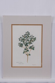
Drawing - Drawing, botanical, Collin Elwyn Woolcock, Correa alba (White Correa), n.d
Part of "Woolcock Gallery Collection". Exhibited CEMA 1989.Drawings of a cutting of plant with dark green foliage and eight white flowers. Single drawing on white background with name and signature in lower corners. The work is on white paper mounted in a double matt (grey on gold), unframed and wrapped in plastic.Front: White Correa Correa alba (lower left) (blue pencil) CEWoolcock (lower right) (brown pencil) Olearia speciosa (Netted Daisy-bush) (lower left) (pencil) Back: 23 (upper left) (pen) White Correa (Correa alba) $80. C E Woolcock (sticker, upper left)collin woolcock, botanical, woolcock collection, cema, botanical drawings -
 Glenelg Shire Council Cultural Collection
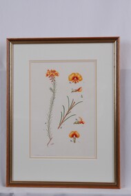
Drawing - Drawing, Botanical, Collin Elwyn Woolcock, Dillwynia Cinnerascens (Grey Parrot-Pea), n.d
Part of 'Woolcock Gallery Collection' Exhibition CEMA 1989.Detail of plant stem on left and on right details of pea flowers and stem views. Stem view on right is a long stem with many fine green leaves (long and thin). At top of stem is a cluster of range pea-flowers and buds. On right of page (t-b): view of pea-flower from top, showing orange petals and dark pink and magenta colouration at centre; side view of emergent bud; stem detail with leaves; side views of full bloom flower; rear view of flower. All views are numbered in both pencil and on typed paper affixed to surface of image. Mounted in double matt (white on faun) framed under glass in wooden frame with gold detail.Front: Dillwynia cinerascens (lower left) (pencil). CEW (lower left, in image) (purple pencil). Back: 41 (upper left) (pen)collin woolcock, botanical, woolcock collection, cema, botanical drawings -
University of Melbourne, Burnley Campus Archives
Plan, Atrium Planting, 1991
... . Atrium Planting Plan ...Student assignmentTracing paper copy of Plant Materials III Assignment 1991.atrium planting, planter box, garden design -
 Glenelg Shire Council Cultural Collection
Drawing, Collin Elwyn Woolcock, Dillwynia hispida (Red Parrot-Pea), n.d
Part of 'Woolcock Gallery Collection' Exhibited CEMA 1989.Stem, flower and leaf details of flowering plant in colour pencil. On left is a stem view depicting a woody central stem with thin leaves and smaller leafed stems ending in clusters of buds or orange pea flowers. On bottom left is a side view of orange pea-flower. On right (t-b): front view of flower; side view of emergent bud; leaf detail; rear view of flower depicting petals and sepals. Mounted in double matt (white on apricot), framed under glass in gold wooden frame. All views numbered in pencil and typed letters and numbers on white paper affixed to paper surface.Front: Dillwynia hispida (lower left) (pencil). 15/?/77 (lower left) (pencil, erased). Back: 40 (top left) (pen)collin woolcock, botanical, woolcock collection, cema -
 Glenelg Shire Council Cultural Collection
Drawing, Collin Elwyn Woolcock, Pultenaea subumbellata (Wiry Bush-Pea), n.d
Part of 'Woolcock Gallery Collection' Exhibited CEMA 1989.Colour drawings of flowering stem and detailed leaf and flower views. The largest stem view depicts thin woody stem with small fine green leaves along length of stem. Branching stems at top end in clusters of buds or small orange and yellow pea flowers. At centre left are 3 details of leaves (front, rear and end views). On right are (t-b): top view of yellow pea flower; side view (orange and yellow); rear view (orange) with sepals; sepal detail; side view in full bloom. All views are numbered in pencil and printed on white paper affixed to image surface. Mounted in double matt (white on faun), under glass in wooden frame with gold detail.Front: Pultenaea sub-umbellata (lower right) (pencil). CEW (signature, lower centre in image) (maroon pencil). Back: 37 (upper left) (pen)collin woolcock, botanical, woolcock collection, cema -
 Glenelg Shire Council Cultural Collection
Drawing, Collin Elwyn Woolcock, Olearia Grandiflora (Mt. Lofty Daisy-Bush). Olearia Tomentosa (Toothed Daisy-Bush), n.d
Part of 'Woolcock Gallery Collection' Exhibited CEMA 1989.Two pen and ink drawings of two daisy plants. On left is stem with fine hairs, large serrated leaves with dark upper side and pale under side, clustered at base of stem, with single flat topped daisy flower at top of stem. To the right is stem view with hairy stem, rippled leaves with dark upper side and pale under side, and three stems at top with 2 daisy flowers in full bloom and one bud. Mounted in a double matt (white on grey), framed under glass in wooden frame with silver detail.Front: O. grandiflora (Mt. Loty Daisy-bush) S.A. O. tomentosa (Toothed Daisy-bush) S.A. (lower left) (pencil). CE Woolcock (signature, lower right) (pencil). Back: 31 (upper left) (pen)collin woolcock, botanical, woolcock collection, cema, bontanical drawing -
University of Melbourne, Burnley Campus Archives
Plan, Emerald Environmental Horticulture Annexe VCAH Burnley, 1992-1996
In 2012 was owned by John Rayner who purchased site from The University of Melbourne in c2006.(1) Tracing paper Sketch. Scale 1:500 dated 26.7.96 drawn by JK (Jill Kellow, Staff). (2) Tracing paper and paper copies, "Proposed Location of Toilet Facility and Septic System." Scale 1:500. (3) Tracing paper copy ,"Revegetation Program Works 1993/94." Scale 1:500. (4) Coloured laminated and tracing paper copies, "Proposed Concept Plan for Development." (5) Tracing paper and paper copies of labelled sketch. Scale 1:500. (6) Proposed Development 1994-95 - List of Proposed New Works. (7) Tracing paper and paper copies, Existing Ornamental Plants, Drawing No E1 drawn by J.J.W. 1.8.92. Scale 1:100. (8) Proposed Amenities Block at Lot Charman Ave, Emerald 3782 by Belgraphic. Drawn by Rosemarie, Plan No 93 003 tp March 1993. Scale 1:50. emerald, john rayner, jill kellow, vcah burnley -
University of Melbourne, Burnley Campus Archives
Plan, The Museum of Modern Art at Heide, 1995
(1) Photocopy of Herb and Plant Location Map, Heide Kitchen Garden, plants numbered, no legend. (2) 1 tracing paper, 1 paper and 1 paper reduced size, Sketch Plan. Scale 1:1000. Drawn by JK (Jill Kellow, Staff) 06.06.1995. (3) Photocopy of Heide Park and Art Gallery Grounds and Planting. Numbered Plant List, 1 Trees, 2 Shrubs.heide, museum of modern art, gardens, jill kellow, bulleen, kitchen garden