Showing 2296 items matching "railway line"
-
 Eltham District Historical Society Inc
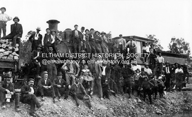
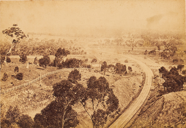
Photograph, First steam train to Hurstbridge
... Hurstbridge railway line... and political agitation for the extension of the railway line. 100 years ...A large group of men of varying ages stand on or beside the first steam train to Hurstbridge. Two hold children on their laps. A small group of seven boys also gather for the photo. The line opened on 2 January 1912 and was officially opened in June.The photo commemorates the culmination of many years of community and political agitation for the extension of the railway line. 100 years later the Hurstbridge railway line remains a vital part of Melbourne's public transport network. This photo forms part of a collection of photographs gathered by the Shire of Eltham for their centenary project book, "Pioneers and Painters: 100 years of the Shire of Eltham" by Alan Marshall (1971). The collection of over 500 images is held in partnership between Eltham District Historical Society and Yarra Plenty Regional Library (Eltham Library) and is now formally known as 'The Shire of Eltham Pioneers Photograph Collection.' It is significant in being the first community sourced collection representing the places and people of the Shire's first one hundred years.Digital image Also black and white copy of original mounted photo (broken) printed on glossy photographic paper 30.5 x 40.5 cm; image size approx. 18.5 x 28 cm (One of 36 photos (5 with duplicate prints) from Kevin Patterson of Nillumbik Historical Society, no captions, subjects largely unknown but mostly of Diamond Creek area and people.)sepp, shire of eltham pioneers photograph collection, hurstbridge, steam train, railroads, group, hurstbridge railway line, steam engine, diamond creek, wattle glen, railway line -
 Eltham District Historical Society Inc
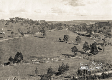
Photograph, Pepper's Paddock, Wattle Glen, c.1927, 1927c
... Hurstbridge Railway Line... apple). Electric Train Hurstbridge Railway Line Railway Line ...Originally dated in pen on reverse as 1920 then crossed out to 1925 but it must be post August 1926 due to presence of an electric train. However no sign of the Sunnyside Estate development (1926?) although most of it could be over the hill out of shot. The furrows suggest that the paddock had been an orchard (probably apple).Digital copy of black and white photographelectric train, hurstbridge railway line, railway line, wattle glen, pepper's paddock, lesley mitchell (nee pepper) collection -
 Orbost & District Historical Society
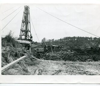
black and white photographs, 15th February 1971
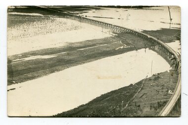
... orbosthistory.com.au) The railway line was destroyed and was not expected... waters near a railway line. 3102.l has a pile driver 3102.2 shows... orbosthistory.com.au) The railway line was destroyed and was not expected ...The 1971 flood was the the worst flood on record. At Jarrahmond it was at least 11 metres and up to one and a half kilometres wide on the flats causing enormous damage to the flood plain. Records say that "The brown floodwater stain in Bass Strait could be seen from passing airliners." Considerable damage was done to railway infrastructure, roads and farms. More information from the APRIL, 2008 newsletter by John Phillips. (see orbosthistory.com.au) The railway line was destroyed and was not expected to be opened for a fortnight. Orbost was cut off by 50 square miles of Snowy River floodwater. These photographs are pictorial records of the 1971 floods which was a significant event in the history of Orbost. They are also associated with the East Gippsland Railway.Three black / white photographs of flood debris and flood waters near a railway line. 3102.l has a pile driver 3102.2 shows a gap in the viaduct and 3102.3 shows men with a tractor cleaning up the debris,3102.1 - on back - "1971 FLOOD REPAIRS TO ORBOST RAILWAY VIADUCT - 15th February 1971. Donated by Audrey Van Den Berg VRH 3693" 3102.2 - on back - " DAMAGE TO RAILWAY VIADUCT ACCUMULATED DEBRIS" 3102.3 - on back - "DAMAGE TO RAILWAY VIADUCT AT ORBOST. CLEAN UP BEGINS"orbost-flood-1971 orbost-viaduct-flood-damage orbost-railway -
 Ballarat Heritage Services
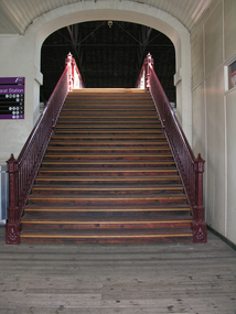
Photograph - Digital photograph, Dorothy Wickham, Ballarat Railway Station Platform Stairs, c2017
... The stairway over the railway line at Ballarat Railway... railway platform The stairway over the railway line at Ballarat ...Ballarat Railway Station opened on 11 April 1862. Most of the 19th century architectural features of the railway station are intact. Its signal boxes and goods sheds are preserved, and it is one of only three stations in Victoria to have had a 19th-century train shed. This photo shows the facade of the south side of the station.The stairway over the railway line at Ballarat Railway Station. ballarat railway station, stairs, railway platform -
![watercolour on paper, [Wharf] by Neville Bunning](/media/collectors/530576742162ef0fa09a2288/items/534748179821f420f8c03915/item-media/55703b552162f116e4a6fdae/item-fit-380x285.jpg) Federation University Art Collection
Federation University Art Collectionwatercolour on paper, [Wharf] by Neville Bunning
... Unframed watercolour painting of a railway line along... of a railway line along a river. [Wharf] by Neville Bunning watercolour ...This item is part of the Federation University Art Collection. The Art Collection features over 2000 works and was listed as a 'Ballarat Treasure' in 2007.Unframed watercolour painting of a railway line along a river.art, artwork, neville bunning -
 Bendigo Art Gallery
Photograph - Work on paper, Nicholas CAIRE, View From The Big Hill, Showing The Line of Railway To Melbourne, 1875
... View From The Big Hill, Showing The Line of Railway To..., Showing The Line of Railway To Melbourne. Photograph Work on paper ...l.l; N.J.CAIRErailway, trains, tracks, bendigo, regional victoria. countryside, travel, albumen, photograph -
 Whitehorse Historical Society Inc.
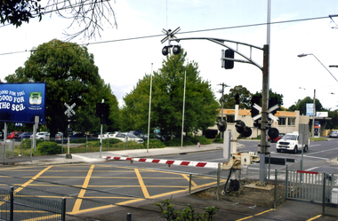
Photograph, Mitcham Railway Crossing, 2012
... Coloured photograph of the railway line over Mitcham Road... Coloured photograph of the railway line over Mitcham Road ...Coloured photograph of the railway line over Mitcham Road as of 2012. The boom gates are down and a white van is coming from the direction of Vermont. In 2013/14 the railway line was reconstructed underground.mitcham railway crossing, railway crossings -
 Eltham District Historical Society Inc
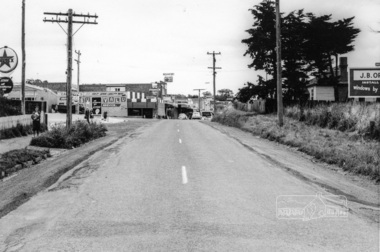
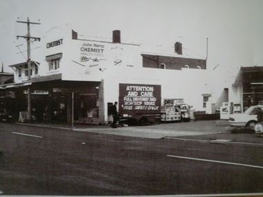
Photograph, Looking west across Main Road at the intersection with Diamond Street, Eltham, February 1968, Feb 1968
... railway line... at that time. duplication eltham main road diamond street railway line ...Shows an early Judge Book building and the Diamond Street railway crossing.In February 1968 an unknown person took a series of photos from the Eltham Hotel at Pitt Street heading north along Main Road through the shopping centre to just north of Elsa Court covering the length of the section of Main Road which was duplicated shortly thereafter. Shows the condition and environment of the streesscape of Main Road, Eltham immediately prior to the duplication between Pitt Street and Elsa Court through the shopping centre. Also shows a number of shops and businesses that operated at that time.Black and white photographduplication, eltham, main road, diamond street, railway line, railway crossing, judge book village -
 Eltham District Historical Society Inc
Photograph, Looking south along Main Road from Diamond Street Railway Crossing, Eltham, February 1968, Feb 1968
... railway line.... duplication eltham main road diamond street railway line railway ...Luck Street enters Main Road from the left behind the Caltex garage. Note the house on right hand land.In February 1968 an unknown person took a series of photos from the Eltham Hotel at Pitt Street heading north along Main Road through the shopping centre to just north of Elsa Court covering the length of the section of Main Road which was duplicated shortly thereafter. Shows the condition and environment of the streesscape of Main Road, Eltham immediately prior to the duplication between Pitt Street and Elsa Court through the shopping centre. Also shows a number of shops and businesses that operated at that time.Black and white photographduplication, eltham, main road, diamond street, railway line, railway crossing, caltex service station, supa-value self service -
 Eltham District Historical Society Inc
Photograph, Looking east along Diamond Street to the railway crossing near intersection with Main Road, Eltham, February 1968, Feb 1968
... railway line... diamond street railway line railway crossing cecil street judge ...Shows houses on Main Road and Cecil Street across Main Road from Diamond Street.In February 1968 an unknown person took a series of photos from the Eltham Hotel at Pitt Street heading north along Main Road through the shopping centre to just north of Elsa Court covering the length of the section of Main Road which was duplicated shortly thereafter. Shows the condition and environment of the streesscape of Main Road, Eltham immediately prior to the duplication between Pitt Street and Elsa Court through the shopping centre. Also shows a number of shops and businesses that operated at that time.Black and white photographduplication, eltham, main road, diamond street, railway line, railway crossing, cecil street, judge book village -
 Eltham District Historical Society Inc
Photograph, Looking north along Main Road from intersection with Cecil Street, Eltham, February 1968, Feb 1968
... railway line... at that time. duplication eltham main road railway line railway ...In February 1968 an unknown person took a series of photos from the Eltham Hotel at Pitt Street heading north along Main Road through the shopping centre to just north of Elsa Court covering the length of the section of Main Road which was duplicated shortly thereafter. Shows the condition and environment of the streesscape of Main Road, Eltham immediately prior to the duplication between Pitt Street and Elsa Court through the shopping centre. Also shows a number of shops and businesses that operated at that time.Black and white photographduplication, eltham, main road, railway line, railway crossing, cecil street -
 City of Kingston
Photograph - Black and white
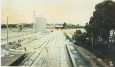
... Highway that was implemented to allow construction of the railway... Highway, Moorabbin to allow the construction of the railway line... the construction of the railway line below the Nepean Highway at Moorabbin ...This photograph depicts the road diversion on Nepean Highway that was implemented to allow construction of the railway line underneath the Nepean Highway at Moorabbin. An "Allourie" Cheese, Honey Canned Ham van is prominent on the left of the image, the railway gates are central and the old Moorabbin Station is visble. Beyond the dates, pedestrians are visible crossing the Nepean Highway. This image is part of a larger collection of images from the Public Transport Corporation displaying train stations and streetscapes in what is now the City of Kingston.In 1958 excavations began for the removal of the level crossing gates at the southern end of the Moorabbin shopping centre on Nepean Highway. The station was also lowered below ground. A diversion route was created to enable the flow of traffic in both directions along the highway.Black and white photograph of road diversion on Nepean Highway, Moorabbin to allow the construction of the railway line below the Nepean Highway at Moorabbin and also to trench the station. This image is part of a larger collection of images from the Public Transport Corporation displaying train stations and streetscapes in what is now the City of Kingston.White adhesive dot sticker: Printed black 199 Handwritten in red ink: 80% Handwritten in black ink on yellow Post-It Note: [indecipherable] 199 - Diversion for Crossing Stamped in blue ink: COPYRIGHT Public Transport Corporation, For reordering photographs, Please quote negative No m 5687, Enquiries C/- PTC Photographic Unit, Telephone switchboard 619 1111railway crossing, railway station, city of moorabbin -
 Frankston RSL Sub Branch
Rail, Steel
... A small section of steel railway line from the Thai Burma... mornington-peninsula A small section of steel railway line from ...A small section of steel railway line from the Thai Burma railway. -
 Orbost & District Historical Society
black and white photographs, C 1981
... of the Orbost Railway Line.... is associated with the history of the Orbost-Bairnsdale railway line ...The Bairnsdale-Orbost railway was opened in 1916 to serve the agricultural and timber industry. Because of the decline in traffic and heavy operating costs, the line was finally closed in August, 1987. The closure of this railway was a controversial issue at the time with many public protests in the district. Protesters stood in front of a VR locomotive holding up signs with " SAVE FUEL JOBS ROADS LIVES ORBOST MR HAMER DON"T LET THIS HAPPEN SAVE RAIL" Others held placards with "DON"T CUT OFF ORBOST" and "We the Children demand our ????secure railway"This item is associated with the history of the Orbost-Bairnsdale railway line and therefore reflects the role that the rail line played in the social and economic history of Orbost. The closure of the line was a significant event in Orbost's history.Seven black / white photographs related to the closure of the Orbost Railway Line.orbost-railway east-gippsland-railway protests-rail-closure -
 Whitehorse Historical Society Inc.
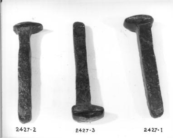
Functional object - Dog Spike
... Dog spikes used with fish plates to secure railway line... spikes used with fish plates to secure railway line ...Dog spikes used with fish plates to secure railway line to the sleepers.trades, blacksmithing, transport, railway -
 Sunbury Family History and Heritage Society Inc.
Photograph, 25th July 1986
... A coloured photograph of widespread snow across a railway... of widespread snow across a railway line and the surrounding area ...Heavy snow fell across Melbourne and surrounding suburbs, including Sunbury, on 25th July 1985. The photograph taken from the pedestrian bridge at Sunbury Railway Station is looking north to the historic Macedon Street bridge. The widespread snow across the metropolitan area on that day caused much chaos.A coloured photograph of widespread snow across a railway line and the surrounding area.sunbury railway station, extreme weather events, snow storms -
 Orbost & District Historical Society
black and white photographs, Snowy River Mail, August 21 1987
... of the Orbost - Bairnsdale Railway Line.... to Orbost when steam engines used the line. He left the railways...-Bairnsdale railway line and therefore reflects the role that the rail ...These photographs are from the Snowy River Mail newspaper, September 9, 1987. Ron Hayward's family ran a shop in Rupert Street, Orbost.This item is associated with the history of the Orbost-Bairnsdale railway line and therefore reflects the role that the rail line played in the social and economic history of Orbost. The closure of the line was a significant event in Orbost's history.Five black / white photographs related to closure of the Orbost - Bairnsdale Railway Line.3104.1 - on back - "A view from Grandview, Newmerella, of the last train to leave Orbost on Friday August 21, 1987. As the afternoon sun lengthens the shadows on the Snowy River flats, the sun also sets on an era in Far East Gippsland transport as the last train crosses the viaduct." 3104,2 - 0n back - "Ron Hayward passes over the staff during the last crew changeover for the last train to run on the Orbost line. Ron Haywood (L) who 39 years and 6 months ago drove the first diesel loco to Orbost (T366T) presents the last staff to the driver, Bill Buckley, who took the last diesel out." 3104.3 - on back -" as above - 2nd paragraph only 3104.4 - on back - " Ron Hayward who took the first diesel engine from Bairnsdale to Orbost on February 21. 1957 when he was stationed at Orbosst. Last Friday he rode on the last diesel to Orbost after obtaining a special pass from V Line , he also handed over the staff for the last change at Orbost. The last driver was Bill Buckley." 3104.5 - on back - "LAST TRAIN ROLLS INTO ORBOST B/A Friday August 28 1987 For Ron Hayward the last train journey on the Orbost rail line was a sad occasion. Mr Hayward took the first diesel engine from Bairnsdale to Orbost on February 21, 1957, whe he was stationed at Orbost. Last Friday he rode on the last diesel too Orbost after obtaining a special pass from V-Line. He also handed over the staff for the last change at Orbost. The last driver was Bill Buckley. Mr Hayward was an engine driver with nhe railways and transferred to Orbost when steam engines used the line. He left the railways in in 1957 but took up a job with them again in 1968. He said also it was a privilege to have been able to ride on the last train, the occasion was a sad one,"east-gippsland-railway railway-closure hayward-ron buckley-bill orbost-bairnsdale-railway -
 Glen Eira Historical Society
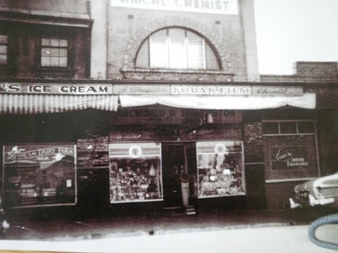
Murrumbeena
... of railway line circa 1951... of railway line circa 1951 Murrumbeena ...3 photographs of Shops in Murrumbeena Road, north of railway line circa 1951murrumbeena, murrumbeena road, shops, pharmacies, milk bars, edmonston, archibald d, clothing shops, louise junior fashions -
 Orbost & District Historical Society
black and white photographs, second half 20th century
... railway line during a flood.... of the Orbost-Bairnsdale railway line and therefore reflects the role ...3154.1 is a postcard of the Orbost viaduct over the flooded Snowy River flats. 4153.2 is of a goods train on the viaduct. 3154.3 is of a loaded goods train with the driver at the window. Two men are standing on the plate and there are two workers below where there is some water and flood debris. 3154.4 is of amachine moving flood debris on the rail line. 3154.5 shows flood damage to the viaduct across the Snowy River flats. Two men are driving a dozer.This item is associated with the history of the Orbost-Bairnsdale railway line and therefore reflects the role that the rail line played in the social and economic history of Orbost.Five black / white photographs associated with the Orbost railway line during a flood.orbost-railway east-gippsland -railway orbost-floods -
Tatura Irrigation & Wartime Camps Museum
Photograph, Stevenson's Grocery
... Frank Stevenson's grocery store, east of railway line... grocery store, east of railway line, Hogan Street c1940 ...Frank Stevenson's grocery store, east of railway line, Hogan Street c1940tatura, buildings, historic -
 Whitehorse Historical Society Inc.
Photograph, Tunstall Hall
... of the railway line in Springvale Road.... photograph of Tunstall Hall north of the railway line in Springvale ...Series of photographs loaned for copying by Robert Collier through Keith Rooney. Photographs have been scanned by Ted Arrowsmith at 300dpi as a 'tiff' and burnt onto a CD Rom. copies of photographs were produced from the CD Rom for inclusion in the album.Black and white photograph of Tunstall Hall north of the railway line in Springvale Road.tunstall hall, tunstall -
 Ringwood and District Historical Society
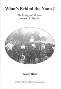
Book, Sandy Ross, What's Behind the Name?, 2005
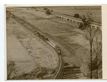
... with the earthworks for the new railway line to Warburton in the background... Vineyard with the earthworks for the new railway line to Warburton ...The history of 50 street names of Lilydale by Sandy Ross, Lilydale & District Historical Society Inc.Front page: Pickers at The Towers Vineyard with the earthworks for the new railway line to Warburton in the background. c1900. -
 Wodonga & District Historical Society Inc
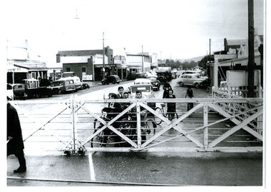
Photograph - High Street, Wodonga Level Crossing, 1954
... opening in 1873 the railway line had crossed High Street... railway line went through the centre of Wodonga and trains... in 1873 the railway line had crossed High Street, originally ...This image is representative of many photographs illustrating the level crossing in the centre of Wodonga. Since its opening in 1873 the railway line had crossed High Street, originally called Sydney Road. It bisected the city with level crossing gates frequently stopping the flow of traffic and pedestrians as trains passed through. Signal Box B stood on the eastern side of the High Street level crossing and a big wheel closed and opened the gates. On 17th September, 1961, it was replaced by boom gates and flashing lights. The railway crossing was removed from High Street as part of the Wodonga Rail Bypass project. This involved a 5.5 kilometres bypass, the elimination of 11 level crossings and the relocation of the Wodonga station. It was moved from its original central location to a position on a new line on the northern edge of the town. The old station closed on 8 November 2008 and the new station opened on 25 June 2011.This image has local and statewide significance as it captures the former crossing in a major railway system. The railways played a critical role in opening up Victoria and connecting Australia for trade, business, social communication and transport.A black and white photo of the railway level crossing in High Street, Wodonga with gates closed. The Melbourne to Sydney railway line went through the centre of Wodonga and trains frequently held up internal vehicular and pedestrian traffic in the main street. railways wodonga, wodonga railway relocation, high st wodonga rail crossing -
 Glen Eira Historical Society
Murrumbeena
... 1 photograph of Shops in Murrumbeena Road, north of railway... photograph of Shops in Murrumbeena Road, north of railway line circa ...1 photograph of Shops in Murrumbeena Road, north of railway line circa 1970’smurrumbeena, murrumbeena road, shops, pharmacies, kemp, john, motor vehicle repair shops, petrol stations -
 Eltham District Historical Society Inc
Photograph, George W. Bell, Eltham Railway, 1960c
... Black and white photograph of railway line near Eltham... collection Black and white photograph of railway line near Eltham ...Black and white photograph of railway line near Eltham trestle bridge c.1960.railways, bridges, eltham, diamond creek, george w bell collection -
Whitehorse Historical Society Inc.
Article, Industry Began With Rail Line, 24/11/1982 12:00:00 AM
... by the opening of the railway line to Lilydale in 1882... to local industry by the opening of the railway line to Lilydale ...Article about the boost provided to local industry by the opening of the railway line to Lilydale in 1882Article about the boost provided to local industry by the opening of the railway line to Lilydale in 1882Article about the boost provided to local industry by the opening of the railway line to Lilydale in 1882railways, clay industries, white brothers, tile factories, mitcham brick and pottery co. ltd, brickworks -
 8th/13th Victorian Mounted Rifles Regimental Collection
Photograph
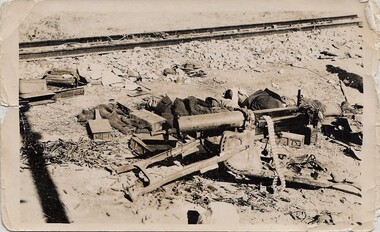
... and other debris beside a railway line in desert... and other debris beside a railway line in desert Photograph ...Black and white photograph of collection of weapons and other debris beside a railway line in desert -
 Eltham District Historical Society Inc
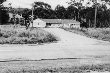
Negative - Photograph, Shire of Eltham, Allendale Road level crossing, Eltham, Jan. 1980
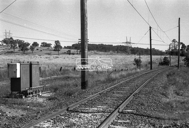
... Hurstbridge Railway Line... Line Level Crossing Power transmission lines railway crossing ...allendale road, diamond creek trail, hurstbridge railway line, level crossing, power transmission lines, railway crossing -
 Eltham District Historical Society Inc
Negative - Photograph, Shire of Eltham, Allendale Road level crossing, Eltham, Jan. 1980
... Hurstbridge Railway Line... Line Level Crossing Power transmission lines railway crossing ...allendale road, diamond creek trail, hurstbridge railway line, level crossing, power transmission lines, railway crossing -
 Eltham District Historical Society Inc
Photograph - Aerial Photograph, Landata, Eltham, Main Rd; Railway Rd to Zig Zag Rd, Dec. 1945
... Eltham-Hurstbridge Railway line...-Hurstbridge Railway line Gastons Homestead Gastons Road Glen Park Road ...Centred on present day Edendale Farm from Glen Park rd to Zig Zag Rd Historic Aerial Imagery Source: Landata.vic.gov.au Aerial Photo Details: Project No :5 Project : MELBOURNE AND METROPOLITAN AREA PROJECT Run : 37 Frame : 60549 Date : 12/1945 Film Type : B/W Camera : EAG4 Flying Height : 10200 Scale : 6000 Film Number : 196 GDA2020 : 37°42'12"S, 145°09'09"E MGA2020 : 337141, 5825486 (55) Melways : 21 K2 (ed. 42)aerial photo, eltham, edendale farm, eltham - yarra glen road, eltham-hurstbridge railway line, gastons homestead, gastons road, glen park road, main road, park road, railway road, wattletree road, zig zag road, neil webster collection