Showing 302 items matching "shopping strip"
-
 Ballarat Tramway Museum
Photograph - Black & White Photograph/s, David Endacott, 14/08/1971 12:00:00 AM
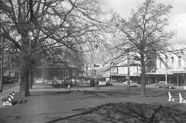
... . Photo taken from the central median strip, has the shops... to the west of Dawson St. Photo taken from the central median strip ...Black and white photograph and negative of an inbound single truck tram in Sturt St. just to the west of Dawson St. Photo taken from the central median strip, has the shops on the north side of Sturt St. in the photograph - such as Gear Chemist. Photo taken 14 August 1971. The Alexandra Bandstand in the foreground. Original print by David Endacott, duplicate print (1270A) by John Phillips 12/1999. Large copy print added 5/2001. Original neg scanned at hi res and updated 11/5/2020. Original neg scanned at hi res and updated 11/5/2020.On original print "Last week of full tram service before phasing out / from Cnr Sturt & Dawson Sts. / Aug 1971" in pencil.trams, tramways, ballarat, sturt st, dawson st., alexandra bandstand -
 Ballarat Tramway Museum
Photograph - Colour Photograph/s, 21/11/1962 12:00:00 AM
Colour print of Bendigo SECV Bendigo tram 3 travelling High St Eaglehawk towards the Eaglehawk Terminus. Photo taken after the tram has passed the photographer. On Kodacolor paper with a Kodak red ink stamp on rear. Tram has dash canopy lights, but no large white strip under the drivers windows. Photo not dated but appears to be at about the same time as 977, 21.11.1962. Has Eaglehawk Town Hall and Post office in background and shops along the south side of High St. Tram showing destination of "Eaglehawk". Tram has White Horse Whiskey ad and another on front dash panel and two roof ads. In photo are advertisements for "Hutton's Bacon" and "Sennett's Ice Cream" on shop roof advertisements.On rear top left hand corner "3"eaglehawk, bendigo, town hall., high st, tram 3 -
 Ballarat Tramway Museum
Slide - 35mm slide/s, Travis Jeffrey, c1961
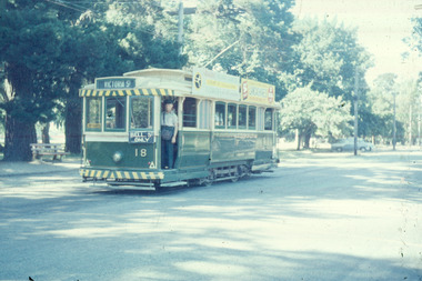
Agfa plastic mount (blue base, white cover) with a photo of No. 18 at Gardens Loop, showing Victoria St., note Bell St. auxiliary board, not correct and door opened on wrong side. Posed photograph. Tram is in the process of being fitted with dash canopy lights and tiger strips. Roof advertisements - Whites Florist shop of 2 Sturt St. and Lancashires. Slide rescanned at 3200 dpi 24-10-2020, jpg replaced, tiff file retained. This file was scanned in 2003 and may show colour changes."BAS 9" in penciltramways, trams, gardens loop, wendouree parade, tram 18 -
 Ballarat Tramway Museum
Slide - 35mm slide/s, Travis Jeffrey, 1961
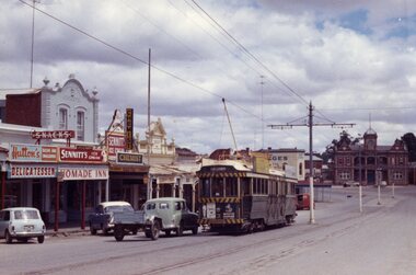
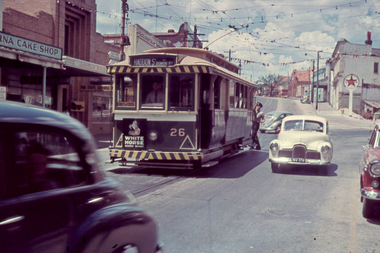
Agfa plastic mount (blue base, white cover) of a photograph of No. 26 at the junction of Bridge and Victoria St. turning pole, with destination of Haddon St, with the Verna Cake shop, State Savings Bank of Victoria and Caltex Service station in the background.. Tram is in the process of being fitted with dash canopy lights and tiger strips and White Horse Whiskey advertisement on the back dash panel. Photo taken early 1961. Slide rescanned at 3200 dpi 24-10-2020, jpg replaced, tiff file retained. This file was scanned in 2003 and may show colour changes."BAS 18" in penciltramways, trams, bridge st, haddon st, victoria st, tram 26 -
 Ballarat Tramway Museum
Photograph - Black and White photograph/s - mounted - set of 2, John Phillips, late 1960's or early 1970's
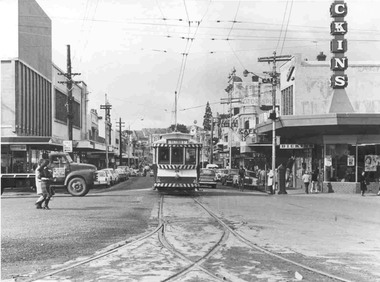
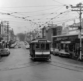
... the use of the trams in Bridge St - the major shopping strip ...Yields information about the use of the trams in Bridge St - the major shopping strip at the time in Ballarat, shows the nature of the strip at the Grenville St end, the motor cars in use at the time and of the some of the shops.Black and White photograph mounted on heavy cardboard backing. Photo of Ballarat No. 26 outward bound to Victoria St, entering the west end of Bridge St. Tram has destination of "Victoria St." Has Dickins, Faull's Shoes and Big W (Woolworths) buildings in image.. Taken by John Phillips late 1960's or early 1970's. Has 6 Velcro dots on rear and marks where mounting devices have been removed on the rear. Note image scanned in two runs through a scanner, resulting in the shading in the image file. .1 - ditto same image, has five Velcro dots mounted on rear.trams, tramways, bridge st, victoria st, tram 26 -
 Ballarat Tramway Museum
Postcard - Folder set, Valentine & Sons Publishing Co, "Beautiful Views in Color of Ballarat Vic", Early 1950's
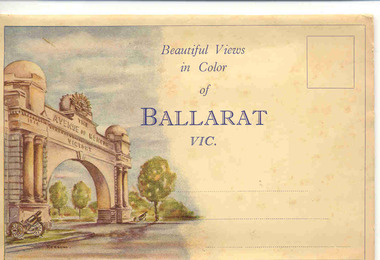
Shows views of Ballarat city, tourist attractions, Lake Wendouree in the 1950's, with some distance views of the trams in the streets. Demonstrates production of souvenirs of the era - folded postcards.Set of 9 coloured views of Ballarat printed with all photos on one side of a folded strip of paper glued within an colour printed light card folder. Published by The Valentine Publishing Co. Pty Ltd of Melbourne and Sydney., titled "Beautiful Views in Color of Ballarat Vic". Front cover has a image of the Arch of Victory on the left hand side with space for title, address area and stamp. Rear of Cover has printer name and a slit for the envelope to be closed over and sealed. 1. The Avenue of Honor and the Arch of Victory 2. The Eureka Stockade Memorial 3. The Old Curiosity shop 4. Town Hall Sturt St. (with trams in distance views, note Myers verandah still there) 5. Sturt St showing Mt. Warrenheip in the distance 6. Picturesque scene in the Gardens 7. The Boat shed and basin, Lake Wendouree 8. Sturt St. (from Greville St and large Robur Tea advertisement on building) 9. The Conservatory in the Gardens. From the motor vehicles in the photograph would say early 1950's. trams, tramways, ballarat, postcards, sturt st, bridge st, gardens, grenville st, lake wendouree -
 Ballarat Tramway Museum
Photograph - Black & White Photograph/s - set of 2, The Courier Ballarat, 18/09/1971 12:00:00 AM
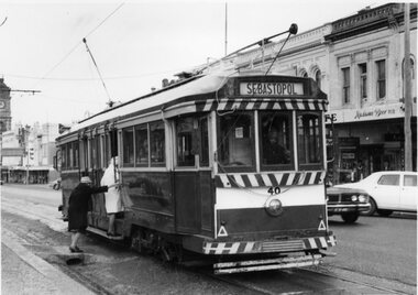
Yields information about the nature of the day on the last full day of operation in Sturt St and how passengers boarded the tram from the median strip.Black and White copy photographs of a newspaper photograph taken by The Courier - photo taken 18/9/1971, one published 20/9/1971 of No. 40 picks up shoppers, Sturt & Dawson Sts corner, last Saturday of service. 3772.1 - Shows two ladies boarding the tram from a crossover over the gutter. 3772.2 - shows the tram just after it left the stop. Has the Ritzy Cafe in the background. Also has a "Cars Stop Here" and a "End of Section sign in the photograph, that looks back along Sturt St. Tram has the destination of Sebastopol. One photo used in the Courier Supplement following the closure of the tramways. Collected by Alan Bradley from the Ballarat Courier early 1980's. See Excel file "Record of Ballarat Courier Photos SEC era" (Archive Documents) for source of details.On rear of 4772.2 stamped "Copyright, The Ballarat Courier Proprietary Limited." and "100%" in black ink, and "92A Rpt" in felt pen.tramways, trams, sturt st, closure, dawson st, signs, tram 40 -
 Ballarat Tramway Museum
Photograph - Black & White Photograph/s, 1880's
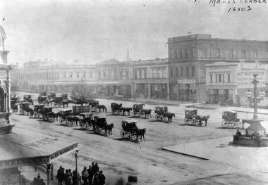
Yields information about the streetscape of Sturt St prior to the formation of the Sturt St median strip, shows horse cabs and buildings on the north side of the street.Black and White copy photograph of a Gold Museum photograph - Sturt St - Marks Corner, 1880's, prior to the formation of the median strip. Has many horse drawn cabs in the centre median strip. Buildings in image - and other shops. Collected by Alan Bradley from the Gold Museum early 1980's. Used in The Golden City and its Tramways - page 11.tramways, trams, sturt st, marks corner -
 Ballarat Tramway Museum
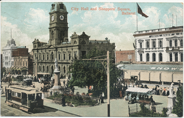
Postcard, Valentine & Sons Publishing Co, "City Hall and Shoppers Square Ballarat", 1905
Printed colour postcard titled "City Hall and Shoppers Square Ballarat". Has an inbound tram showing the Grenville St sign on the rear, and one of the crossbench cars loading passengers outside the Town Hall. Shows Snows building, people in the median strip - busy holiday or a Sunday. Images of the front and back of the card and a close-up of the two trams in the bottom left-hand corner. Note the lamp or coloured destination sign on the roof of the inbound tram. On the rear, the postcard has been divided into two with the words "Post Card" and "Printed in Great Britain" on the top, a "Valentine Series" on the side. Addressed to Miss J Johnstone, 30 Weighbridge St, Flemington, and with the words "Dear Jeannie, / How do you like this one. / Maggie". Has a 1d Victorian stamp, cancelled in Melbourne "5" with the date "25-1-05" This is an incorrect date - electric trams did not open until August 1905. 2nd copy unused.Yields information about the intersection of Sturt and Armstrong StreetsPostcard, coloured, divided back - used.trams, tramways, sturt st, esco, town hall, cross bench tram, snows, armstrong st -
 Ballarat Tramway Museum
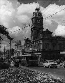
Photograph - Black & White Photograph/s, Jim Seletto, Feb. 1958
Yields information about the appearance of Sturt St at the time of Ballarat Begonia Festival, 1957 - the flowers in the medium strip, the tram and the shoppers in particular the women.Black and white photograph of Ballarat No. 14 west bound in Sturt St during the 1957 Begonia Festival with the Town Hall (with a Begonia Festival sign on it), and other buildings in the background. Has the Australian Mutual Life Building, the Odeon Theatre buildings. In the centre median strip, there is a large arrangement of flower beds and many women shoppers crossing the road, motor vehicles and a lady on a bicycle. No. 14 has the destination of Haddon St via Drummond Nth. Festoon lighting is strung out along the street.On rear in red ink "Ballarat Car 14 Sturt St B'rat Summer '57" and the stamp of Jim Seletto.tramways, trams, sturt st, begonia festival, town hall, shoppers, tram 14 -
 Ballarat Tramway Museum
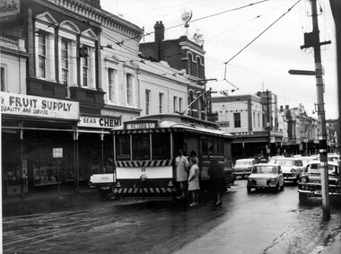
Photograph - Black & White Photograph/s and Black and White photograph/s - mounted, John Phillips, 1968
... the use of the trams in Bridge St - the major shopping strip ...Yields information about the use of the trams in Bridge St - the major shopping strip at the time in Ballarat, shows the nature of the strip, the passengers (all ladies) and the motor cars in use at the time.Black and white print of No. 28, picking up four lady passengers at the junction in Bridge St, Stones Corner. Tram has the destination of Victoria St. Photo taken late 1960's, early 1970's. In the photo are the Bank of NSW buildings, Gear Chemist and Hotel on the Corner of Peel and Bridge Sts. Print and photo by John Phillips. Second copy added 13/4/2009 - see history .1 - Black and White photograph mounted on heavy cardboard backing, used for display purposes. On rear of second print - "Copyright John Phillips 1968 Bridge St" and in bottom right hand corner "William Scott" and address label.tramways, trams, bridge st, stones corner, passengers, tram 28 -
 Ballarat Tramway Museum
Slide - 35mm slide/s, Harry Jackson, Dec. 1971
White cardboard mount, 35mm slide, from the Association of Railway Enthusiast's film strip titled "Provincial Tramway Film Strip" of a Bendigo No. 3 standing at the Eaglehawk terminus with the Town Hall in the background. Tram reflected in shop windows and shows some of the verandas of High St. Eaglehawk. The film strip notes (Reg. Item 2560), provided the following caption details: "Bogie car No. 3 stands at "EAGLEHAWK" in the hot midday sun. = Dec. '71 (Harry Jackson) See image btm2597p.tif for high level scan of image. Stamped on base of slide "11807" and written in ink on top edge "No. 3 Eaglehawk"tramways, trams, are, film strip, high st, eaglehawk, tram 3 -
 Ballarat Tramway Museum
Photograph - Digital image Set of 2, Peter Bruce, "No.30 Bridge and Main", 1970s
... Bridge St Ballarat and its associated shopping strip. Trams ...Yields information about Bridge St Ballarat and its associated shopping strip.Digital image, black and white, two images, of No. 30 in Bridge St. 4605.1 - at Stones Corner, enroute to Mt Pleasant with Rodda's, Gill & O'Keffe, C.W. Pennan, ANZ Bank and other shops in the background. Note the signal lamps on the right hand side of the photo above the tram stop sign and how the overhead was arranged at this junction. 4605.2 - at Grenville St end, with Faulls Shoes, Suttons HMV and other shops in the background. Photo taken by Peter Bruce 1970's and 1971, prior to the closure of the Ballarat tramway system. Peter's Title of image: "No.30 Bridge and Main" and "No. 30 Bridge St up end".trams, tramways, bridge st, mt pleasant, tram 30 -
 Buninyong & District Historical Society
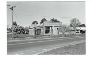
Photograph - Original B/W Photograph, Former Whyke's Grocer building, Warrenheip St, Buninyong, 18 September 1993
Original building was established by Whyke's family Grocery, built in 1860s. Stripped to apricot brickwork. Verandah removed. Situated East Side of Warrenheip St between Eyre St and Forest St, Buninyong. Building much altered and used as a restaurant in 1970s. Fell into disrepair. Revival took place but not restoration. 1990s under threat of demolition if not conforming to council safety requirements. Building has since been renovated as a pizza restaurant (2023). Vacant lots have since been built on.Established by a prominent local family, an example of a mid 19th century shop. Black and white photo of former Whykes Grocer, 1860's. Streetscape photo of former Whykes Grocer brick building. Power pole with Warrenheip St sign. 3 other shopfronts visible, street trees and vacant land between shops.buninyong, whykes, grocery, building, street scape, warrenheip st -
 Tennis Australia
Racquet, Circa 1969
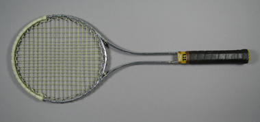
A Wilson 'T2000' metal tennis racquet, with double shaft; yellow plastic shaft casing & gold whipping. Handle wrapped with brown leather. Net anchored to metal wire wrapped around head frame. Yellow plastic butt cap with white label featuring 'W' logo in red. White plastic reinfrcement strip fixed around crown. Adhesive label inside shaft states: STRUNG WITH PRIDE & TLC/SOUTH COAST TENNIS & GOLF SHOPS. Materials: Metal, Plastic, Adhesive tape, Nylon, Adhesive label, String, Leathertennis -
 Kew Historical Society Inc
Plan - Subdivision Plan, Kia Ora Estate, 1930s
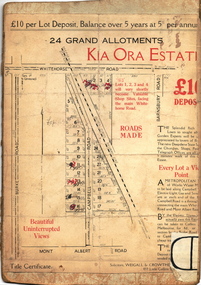
Twenty-five grand allotments were offered for sale in the subdivision known as the Kia Ora Estate in Balwyn in the early 1930s. The streets identified in the subdivision include Whitehorse Road, Barnsbury Road, Campbell Road, Mont Albert Road and Burke Road. The lots were advertised for £10 deposit, with the balance to be paid over 5 years at 5 per cent per annum. The lots bordering Whitehorse Road were nominated as potential valuable shop sites, while the Mont Albert Road lots were advertised as having ‘wonderful views’. The Outer Circle Railway Line is shown traversing the subdivision. The route of the Railway in this area is now a walking/bike track bordered by strips of parkland.subdivision plans - balwyn, kia ora estate -
 Kew Historical Society Inc
Photograph, Stuart Tompkins Studio, Electricity Supply Poles, Warrigal Road, Ashwood, 1965
Research provided by Stuart Tompkins Studio, Box Hill, into alternatives for median strip street lighting to be used in Burke Road, Kew. The photographers identified variants in different suburbs appropriate to Kew's needs.The series from which the photograph is drawn provides a snapshot by a commercial photographic studio of each named vicinity in 1965 as well as providing examples of public works infrastructure being commissioned by local government in the 1960s. The photos originally formed part of the Engineering Department's files in the City of Kew before being donated to the kew Historical Society.Electricity Supply Poles, Warrigal Road, Ashwood, 1965. Stuart Tompkins Studio provided this photograph for the Kew City Council. The photograph, taken at the intersection of Warrigal Road and High Street South, Ashwood looks north along High Street Road. The intent of the photograph was to provide the Council with models of electricity supply poles. In the photo, wooden and steel poles can be seen in the median strip. The photograph also includes the shops bordering High Street Road during this period. [There are three copies of this photograph in the Collection.]. Typed inscription on reverse: "Electricity Supply Poles. Photographed for Kew City Council 8/2/65. No.4 Warrigal Road - Ashwood. South of High Street Road looking north. Wooden and steel poles with different brackets in median strip." Studio stamp: "Stuart Tompkins Studio. 547 Station Street, Box Hill. WX1439."electric light poles, public works -- 1960s, civic infrastructure -- 1960s -
 Kew Historical Society Inc
Photograph, Stuart Tompkins Studio, Electricity Supply Poles, Warrigal Road, Ashwood, 1965
Research provided by Stuart Tompkins Studio, Box Hill, into alternatives for median strip street lighting to be used in Burke Road, Kew. The photographers identified variants in different suburbs appropriate to Kew's needs.The series from which the photograph is drawn provides a snapshot by a commercial photographic studio of each named vicinity in 1965 as well as providing examples of public works infrastructure being commissioned by local government in the 1960s. The photos originally formed part of the Engineering Department's files in the City of Kew before being donated to the kew Historical Society.Electricity Supply Poles, Warrigal Road, Ashwood, 1965. Stuart Tompkins Studio provided this photograph for the Kew City Council. The photograph, taken at the intersection of Warrigal Road and High Street South, Ashwood looks north along High Street Road. The intent of the photograph was to provide the Council with models of electricity supply poles. In the photo, wooden and steel poles can be seen in the median strip. The photograph also includes the shops bordering High Street Road during this period. [There are three copies of this photograph in the Collection.]. Typed inscription on reverse: "Electricity Supply Poles. Photographed for Kew City Council 8/2/65. No.4 Warrigal Road - Ashwood. South of High Street Road looking north. Wooden and steel poles with different brackets in median strip." Studio stamp: "Stuart Tompkins Studio. 547 Station Street, Box Hill. WX1439."electric light poles, civic infrastructure - 1960s, public works -- 1960s -
 Kew Historical Society Inc
Photograph, Stuart Tompkins Studio, Electricity Supply Poles, Warrigal Road, Ashwood, 1965
Research provided by Stuart Tompkins Studio, Box Hill, into alternatives for median strip street lighting to be used in Burke Road, Kew. The photographers identified variants in different suburbs appropriate to Kew's needs.The series from which the photograph is drawn provides a snapshot by a commercial photographic studio of each named vicinity in 1965 as well as providing examples of public works infrastructure being commissioned by local government in the 1960s. The photos originally formed part of the Engineering Department's files in the City of Kew before being donated to the kew Historical Society.Electricity Supply Poles, Warrigal Road, Ashwood, 1965. Stuart Tompkins Studio provided this photograph for the Kew City Council. The photograph, taken at the intersection of Warrigal Road and High Street South, Ashwood looks north along High Street Road. The intent of the photograph was to provide the Council with models of electricity supply poles. In the photo, wooden and steel poles can be seen in the median strip. The photograph also includes the shops bordering High Street Road during this period. [There are three copies of this photograph in the Collection.]. Typed inscription on reverse: "Electricity Supply Poles. Photographed for Kew City Council 8/2/65. No.4 Warrigal Road - Ashwood. South of High Street Road looking north. Wooden and steel poles with different brackets in median strip." Studio stamp: "Stuart Tompkins Studio. 547 Station Street, Box Hill. WX1439."electric light poles, public infrastructure -- 1960s, civic works -- 1960s -
 Kew Historical Society Inc
Journal, Kew Historical Society, Newsletter No.127, June 2019
... . Edgevale Road: a small shopping strip in Kew / Judith Scurfield p10 ...Yarra Views / Robert Baker p1. Society News: Events, Grants, New exhibition, [Donations to] The collection, RHSV award p3. Stitch Your Way into History / Collections Group p4. Broadcasting from Kew / David White p5. Kew Historical Society 1974-1989 / Robert Baker p7. Resurrection: the Outer Circle railway - Part 2 / Desley Reid p9. Edgevale Road: a small shopping strip in Kew / Judith Scurfield p10. Membership & Donations p12.Published quarterly since 1977, the newsletters of the Kew Historical Society contain significant research by members exploring relevant aspects of the Victorian and Australian Framework of Historical Themes. Frequently, articles on people, places and artefacts are the only source of information about an aspect of Kew, and Melbourne’s history.non-fictionYarra Views / Robert Baker p1. Society News: Events, Grants, New exhibition, [Donations to] The collection, RHSV award p3. Stitch Your Way into History / Collections Group p4. Broadcasting from Kew / David White p5. Kew Historical Society 1974-1989 / Robert Baker p7. Resurrection: the Outer Circle railway - Part 2 / Desley Reid p9. Edgevale Road: a small shopping strip in Kew / Judith Scurfield p10. Membership & Donations p12.kew historical society (vic.) -- periodicals., kew historical society (vic.) -- newsletters, kew historical society (vic.) -- journals -
 Kew Historical Society Inc
Photograph, J E & B L Rogers, High Street, Looking to Junction, 1960s
... street -- kew (vic.) shopping strips -- melbourne "High St ...This work forms part of the collection assembled by the historian Dorothy Rogers, that was donated to the Kew Historical Society by her son John Rogers in 2015. The manuscripts, photographs, maps, and documents were sourced by her from both family and local collections or produced as references for her print publications. Many were directly used by Rogers in writing ‘Lovely Old Homes of Kew’ (1961) and 'A History of Kew' (1973), or the numerous articles on local history that she produced for suburban newspapers. Most of the photographs in the collection include detailed annotations in her hand.The Rogers Collection provides a comprehensive insight into the working habits of a historian in the 1960s and 1970s. Together it forms the largest privately-donated collection within the archives of the Kew Historical Society.Small, black and white photo of High Street, Kew, looking west towards Kew Junction."High St / Looking towards Junction / Jim's / 4high street -- kew (vic.), shopping strips -- melbourne -
 Kew Historical Society Inc
Slide - High Street, Kew, 1980
... -- kew (vic.) shopping strips -- kew (vic.) 35mm colour ...One of a group of slides taken by members of the Society of built heritage in Kew in 1979-80. The selection of subject matter reflects the priorities of the period. The colour of some slides has degraded.The slides represent a snapshot in time of built architecture in Kew, much of which has changed in the forty-plus period since they were created. 35mm colour transparency (slide) of the Kew shopping centre looking west towards Kew Junction in 1980.high street -- kew (vic.), commerce -- kew (vic.), shopping strips -- kew (vic.) -
 Surrey Hills Historical Society Collection
Photograph, Philip Warren-Smith at J&V Warren-Smith Auto Service, 1991
... shopping strip was assessed for heritage protection by Lovell Chen ...The land along the eastern side of the Union Road shops between Montrose Street and the railway line was originally owned by the Zeplin family. It was subdivided in 1914 and offered for sale as individual sites. Building did not occur until after WW1 and after the creek across Union Road had been barrelled. The garage was built at 145 Union Road in 1925. It has had continuous use as a garage since then. Originally there were petrol bowsers on the footpath. The façade of the building is remarkably the same as it was in 1925 when David Denholm was the first proprietor. He remained until c1950 and was followed by Benchley Motors P/L, then Spenden Motors P/L. John and Val Warren-Smith purchased it in c1980. In 2019 their family, including Philip and Glenn Warren-Smith and 2 of Philip's sons, still operate it as J&V Warren-Smith Auto Service.The Union Road shopping strip was assessed for heritage protection by Lovell Chen in June 2011 (Surrey Hills and Canterbury Hill Estate Heritage Study: Union Road Commercial Precinct Citation). Within this report two buildings were mentioned as, unusually, still performing their original role. These were Dartnell’s Pharmacy at 376-378 Canterbury Road (contributory) and the motor garage at 145 Union Road (contributory). This is one of a number of 3 images taken in 1991 which document the interior and function of the building.A colour photo of a man in green overalls inside the workshop of a garage. There are two cars up on hoists and three towards the back of the workshop.philip warren-smith, val warren-smith, john warren-smith, j&v warren-smith auto service, benchley motors p/l, spenden motors p/l, garages, union road, businesses, glenn warren-smith, cars -
 Surrey Hills Historical Society Collection
Photograph - Black and White Photograph, J & V Warren-Smith Auto Service, 1991
... shopping strip was assessed for heritage protection by Lovell Chen ...The land along the eastern side of the Union Road shops between Montrose Street and the railway line was originally owned by the Zeplin family. It was subdivided in 1914 and offered for sale as individual sites. Building did not occur until after WW1 and after the creek across Union Road had been barrelled. The garage was built at 145 Union Road in 1925. It has had continuous use as a garage since then. Originally there were petrol bowsers on the footpath. The façade of the building is remarkably the same as it was in 1925 when David Denholm was the first proprietor. He remained until c1950 and was followed by Benchley Motors P/L, then Spenden Motors P/L. John and Val Warren-Smith purchased it in c1980. In 2019 their family, including Philip and Glenn Warren-Smith and 2 of Philip's sons, still operate it as J&V Warren-Smith Auto Service.The Union Road shopping strip was assessed for heritage protection by Lovell Chen in June 2011 (Surrey Hills and Canterbury Hill Estate Heritage Study: Union Road Commercial Precinct Citation). Within this report two buildings were mentioned as, unusually, still performing their original role. These were Dartnell’s Pharmacy at 376-378 Canterbury Road (contributory) and the motor garage at 145 Union Road (contributory). This is one of a number of 3 images taken in 1991 which document the interior and function of the building.A colour photo of a man in green overalls working on a car with its bonnet up.john warren-smith, val warren-smith, philip warren-smith, glenn warren-smith, j&v warren-smith auto, union road, businesses, garages, cars, mechanics -
 Surrey Hills Historical Society Collection
Photograph, Wally Hoersch of J&V Warren-Smith Auto, 1991
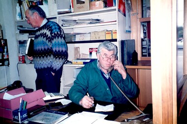
... . The Union Road shopping strip was assessed for heritage protection ...The land along the eastern side of the Union Road shops between Montrose Street and the railway line was originally owned by the Zeplin family. It was subdivided in 1914 and offered for sale as individual sites. Building did not occur until after WW1 and after the creek across Union Road had been barrelled. The photo was taken in the office of the garage which was built at 145 Union Road in 1925. It has had continuous use as a garage since then. Originally there were petrol bowsers on the footpath. The façade of the building is remarkably the same as it was in 1925 when David Denholm was the first proprietor. He remained until c1950 and was followed by Benchley Motors P/L, then Spenden Motors P/L. John and Val Warren-Smith purchased it in c1980. In 2019 their family, including Philip and Glenn Warren-Smith and 2 of Philip's sons, still operate it as J&V Warren-Smith Auto Service. The man on the phone is Walter Kurt (Wally) Hoersch. Warmly regarded and often mistakenly thought to be Philip's father, he was not a member of the family. Wally had an interesting background, not known to many. He was born in the German Templer colony of Sarona in Palestine. It had been established in Ottoman Palestine in 1871 and is now a suburb of Tel Aviv. In July 1941, 188 people from Sarona were deported to Australia on the Queen Elizabeth. Wally's family were amongst them. They were interned in Tatura in Central Victoria until 1947. Wally lived in Mont Albert North and later Templestowe; he died on 21/7/2002.The Union Road shopping strip was assessed for heritage protection by Lovell Chen in June 2011 (Surrey Hills and Canterbury Hill Estate Heritage Study: Union Road Commercial Precinct Citation). Within this report two buildings were mentioned as, unusually, still performing their original role. These were Dartnell’s Pharmacy at 376-378 Canterbury Road (contributory) and the motor garage at 145 Union Road (contributory). This is one of a number of 3 images taken in 1991 which document the interior and function of the building.A colour photo of a man sitting behind a desk in an office on the phone. There is another man standing behind him to his right.john warren-smith, val warren-smith, philip warren-smith, glenn warren-smith, walter hoersch, wally hoersch, j&v warren-smith auto, union road, businesses, garages, benchley motors p/l, spenden motors p/l, -
Canterbury History Group
Letter - Wasteful expenditure, 2010
Letter to the Progress Leader describing the laying of cobblestone strips in Maling Road by the Boroondara Council as a waste of time, resources and money. Includes a coloured photograph of the work in progress.canterbury, maling road, city of boroondara, roads and streets, shops -
City of Kingston
Photograph - Colour, 29 January 1993
Bonbeach is a small beachside suburb located between Chelsea and Carrum. The station was opened in 1926 and was the last to be established in the group from Aspendale to Carrum. Urban growth began after World War II. State primary and high schools were opened in 1958 on land in Breeze Street that was once occupied by The Australian Glass Manufacturers. Immediately east of the school sites is the Patterson River Golf Club. The Bonbeach sports reserve has five ovals and is home to the Bonbeach football and baseball clubs. The suburb borders the Edithvale-Seaford Wetlands which is the remnant site of the Carrum Carrum swamp, once the home of the Bunurong people.Bonbeach was originally a seaside destination for holidaymakers and the housing comprised of holiday homes and gradually more permanent residents. It was not until 1926 that Bonbeach had its own railway station. From 1906 until the late 1940s sand was quarried on the east side of the railway line and used in the manufacture of glass. The Australian Glass Manufacturers sold this land in residential blocks and Bonbeach's permanent population spread from the coastal strip across to the other side of the railway line. Laminated colour aerial photograph of the suburb of Bonbeach and also the southern section of neighbouring Chelsea within the City of Kingston. The extent of this 1993 aerial image includes: Top left - Maury Road at the south end of the Chelsea shopping Centre; Top right - Scotch Parade Chelsea Bottom left - Monica Avenue in Bonbeach; Bottom right - Patterson River Golf Club. Landmarks include St Joseph's Church and Primary School, Chelsea Primary School, Bonbeach Station, Bonbeach Fotball Club sports playing fields and Bonbeach Life Saving Club. The Edithvale Wetlands is featured prominently to the right-hand side of the image. Black typed writing on white adhesive label: No. 6662 Black typed writing on white adhesive label: 26E/6662, 29/1/93, 4.25 pm Black typed writing on white adhesive label: 29-1-93 Black typed writing on white adhesive label: P000109 Circular yellow adhesive sticker bonbeach, chelsea -
City of Kingston
Photograph - Colour, 6 March 1993
... residential with a shopping strip along Nepean Highway but little ...Edithvale is a suburb in the City of Kingston. It is located between Aspendale and Chelsea on the Port Phillip Bay and built within remnant areas of the Carrum Carrum swamp. The foreshore precinct comprises a wide sandy beach, with low sand dunes and numerous historic boat sheds. The suburb consists of older style dwellings and former holiday houses, combined with mid-century housing and newer homes. The large blocks are increasingly subdivided and the existing dwellings demolished to accommodate units and townhouses, thus changing the landscape of the area and reducing the tree canopy.The beachside suburb of Edithvale was previously part of the extensive Carrum Carrum Swamp. The area was once a source of fish and eels for the Mayone-Bulluk clan of the Bunurong people. Over time the area was drained and predominantly devoted to dairy farming and holiday houses. The farms were gradually sold and subdivided with a large number of homes built after World War II and in the 1960s. Edithvale is mainly residential with a shopping strip along Nepean Highway but little significant industry was ever established in the area apart from a plaster works and confectionary factory, both now closed.Laminated aerial colour photograph of Edithvale as viewed from Alexandra Avenue in the north to Ella Grove Chelsea/Edithvale in the south. regents Park Aspendale can be seen in the top left. The area is built-up with residential housing and facilities including Edithvale Primary School, numerous churches and the Edithvale Railway station. Large sections depict the remnant Carrum Carrum swamp. Edithvale Common and the former "Duck Inn" (Melbourne Water/Friends of Edithvale Seaford Wetlands) can be seen. Edithvale Recreational reserve, the valodrome and Edithvale Public Golf Course are prominent. The image shows vacant land in the area now known as Aspendale Gardens and the newer residential section of Chelsea Heights is not developed. A bike path has been established to cover the secondary drain. The Golf Links Court residential development located off Hughes Avenue is a large vacant block.Black type on white adhesive label: 6-3-93 Black type on white adhesive label: 25/9211, 6/3/93, 11.20 am Black type on white adhesive label: 9211 Yellow circular adhesive sticker Black pencil: 9211 6-3-93 arrow pointing Nedthvale, carrum carrum swamp, aspendale, chelsea -
 Charlton Golden Grains Museum Inc
Photograph, West end Charlton High St c. 1987, c.1989
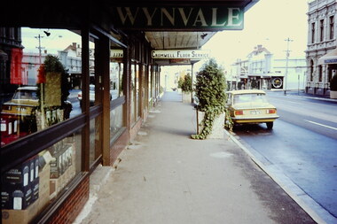
Shops at the west end and on the south side of High St. Eddie Harris Mensland, and three small shops; Charles McKinley's Land Sales Agency, Hillier's Dr Cleaners and Manchester Unity. The three small shops were damaged by fire and demolished in the 1990s. Series of photos taken for use by the Charlton Shire.Colour photo of shops at the west end and on the south side of High St.Eddie Harris Mensland, Mickinley's Land Sales Agency, Hillier's Dr Cleaners and Manchester Unity. Sign on median strip pointing to Rotary Park, Public Conveniences, Electric Barbeque. Also a Give Way sign.eddie harris mensland, charles mckinley, hilliers, charlton, business, industry -
 Melbourne Tram Museum
Ephemera - Timetable, Melbourne & Metropolitan Tramways Board (MMTB), "Timetable of first and last trams and buses also All-night and Sunday morning services", Jan. 1946
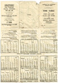
titled "Timetable of first and last trams and buses also All-night and Sunday morning services", setting out services, fares, city concession fares, all night fares, fare sections, and that strips of 2d and 3d tickets could be bought from conductors. Has a "advertisement" for shoppers travelling in comfort between 930 and 430, dinner and afternoon tea at the Wattle Park Chalet and Family excursion tickets to the Beaches and Wattle Park - 2/6. See Reg Item 1751 for an April 1951 version, 2140 for a 1935 version and 8209 for a March 1942 version. Yields information about MMTB tram and bus servicesTimetable printed on off white paper, folded into 9, Dated January 1946. Printed by Sands and McDougall - has their logo printed on the middle section of the outside fold. See Reg Item 1751 for an April 1951 version and 2140 for a 1935 version.trams, tramways, timetables, first tram, wattle park, fares, all night services