Showing 13655 items
matching stations
-
 Ballarat Tramway Museum
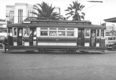
Photograph - Black & White Photograph/s, Leon Marshall-Wood, 29/03/1948 12:00:00 AM
Yields information about Geelong trams in the late 1940's and the appearance of tram 23.Black and white print of Geelong 23 at the Railway Station, awaiting passengers for the AETA Special. Photo dated 29/3/1948. Based on the handwriting on btm5869i, the photo is by Leon Marshal-Wood. Negative scanned at 3200dpi 9/6/2020 9/6/2020.On the rear in ink "29/3/1948, Geelong # 23" at railway station"trams, tramways, geelong, railway station, radiax trucks, trucks, aeta, tram 23 -
 Whitehorse Historical Society Inc.
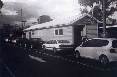
Photograph, Mitcham Railway Station
2013 - Station dismantled - going undergroundColoured photograph of Mitcham Railway Station looking west towards the city - 2012mitcham railway station, railways -
 Sunbury Family History and Heritage Society Inc.
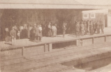
Photograph, c1920s
The crowd of people are waiting on Platform 1 at Sunbury Railway Station. A sepia photograph of a crowd standing on a station platform waiting for a train to arrive.sunbury railway station -
 Otway Districts Historical Society
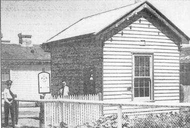
Photograph, Beech Forest Railway Station, 1903, 1903
In 1903, before the extension to Crowes, Beech Forest Railway Station was the terminus, already 3 roads wide with Station building, outshed, Goods Shed, and three small departmental residences. An NQR wagon near the Goods Shed is loading timber while a further NQR wagon sits outside the station building.Photograph, B/W, 174mm x 267mm. Beech Forest Railway Station, 1903.beech forest; railways; station; -
 Kiewa Valley Historical Society
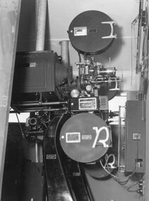
Photograph – Black and white photograph of an unidentified piece of equipment (possibly projection equipment) presumably used by SECV Hydro
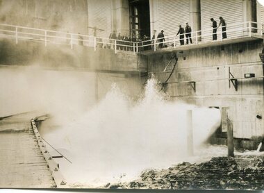
The Victorian Government took control of power generation in 1921, forming the State Electricity Commission (SEC). Construction approval on a grand scheme to build five power stations with a combined capacity of 289 megawatts was received in 1938, and the Clover Power Station was completed by 1945. The original scheme was dramatically pruned after World War II and only two more power stations were built. The Junction Dam and Clover Dam Power Station, stages of the Kiewa Hydro-Electric Scheme, were needed to meet the increased power demands of the wartime industry in Victoria. Clover added 26 megawatts to the grid. Junction Dam was completed and ready to hold water by September 1943, but was emptied in December 1943 and not filled again until May 1944. Construction of Clover Power Station commenced in July 1941 and both turbines were in service by May 1945.Clover Power Station and Junction Dam were part of the Kiewa Hydro Electric Scheme constructed by the State Electricity Commission of Victoria.Black and white photograph of an unidentified piece of equipment (possibly projection equipment) presumed to be used in one of the power stations ie: Clover Power Station or Junction Dam as part of the Kiewa Hydro Electric Schemeprojection equipment; -
 Stawell Historical Society Inc
Photograph, Police Station article 1955
Police Station Clemes Street. Sergeant W McCurrach on right. Left is Constable Jack Nisbet. On Back. Stawell Police Station Clemes St Stawell. The Stawell Times Friday February 25 1955. On right Sgt W McCurrach on left Constable Jack Nisbet.police, law -
 Stawell Historical Society Inc
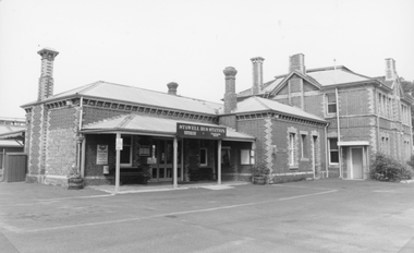
Photograph, Railway Station Stawell
Stawell Railway StationStawell Bus Station Sign. VLine Sign and othe rsigns visable but unreadablestawell railways transport -
 Port Fairy Historical Society Museum and Archives
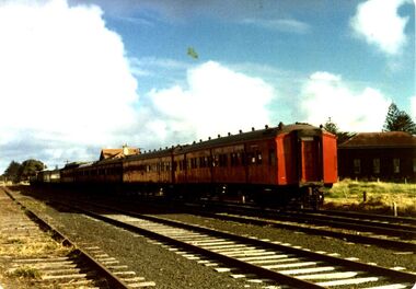
Photograph, 1970's
Train and red carriages Port Fairy railway station c.1970Coloured photograph of train with red ‘rattler’ carriages at Port Fairy Stationtransport, rail, road, carriage, railway station, 1970 -
 Whitehorse Historical Society Inc.
Photograph, The Railway Crossing from Corner of Springvale Road & Station, 1/06/2009
One of a collection of photographs taken of the Nunawading Railway Station prior to the lowering of the railway line and building of the new railway station on the western side of Springvale Road so that the Springvale Road Rail Crossing can be eliminated.Black & white photograph of he precinct surrounding the Nunawading Station and the Springvale Road Railway crossing. This photograph is of the Railway Crossing from corner of Springvale Road & Station. See NP 3545 to NP3567for the complete set of photographsnunawading railway station, springvale road, nunawading, redevelopment of railway line/springvale road., station street nunawading -
 Greensborough Historical Society
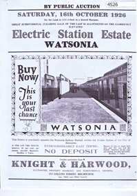
Advertising Leaflet, Electric Station Estate; Watsonia; Saturday 16th October 1926, 16/10/1926
One of two brochures advertising the auction on 16th October 1926 of the last 50 allotments of the Electric Station Estate, with a photograph of the railway station. Refer to item 4503 for other brochure.1p. B & W Photocopy of auction brochure, with photograph of new Watsonia Railway Station.watsonia railway station, watsonia -
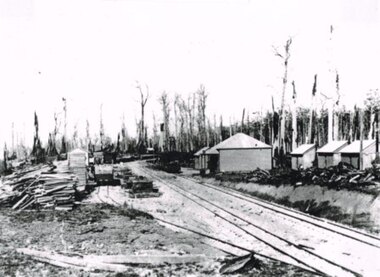
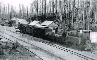 Otway Districts Historical Society
Photograph, Crowes Station, 1912, 1912
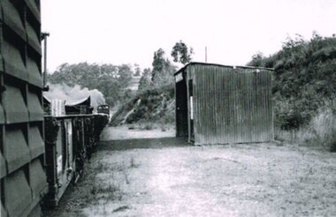
Locomotive 8A, two freight cars, a passenger car and a guard's van leave Crowes Station for Beech Forest. Crowes Station consists of a two-layered station building, a goods shed and a toilet at a three-line terminus.Crowes Station soon after opening in 1912 with Locomotive 8A about to depart for Beech Forest and Colac.crowes; station; railway; locomotive; -
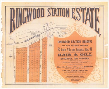
 Ringwood and District Historical Society
Plan, Ringwood Station Estate, Subdivision, Ringwood, Victoria - circa 1925
ID 5224 note: Further information relating to squares marked H, F, G, J, and K included in ID 5225 - Ringwood Shop and Dwelling Estate.Hand drawn plan of Ringwood Station Estate showing allotments for sale, with two typed pages attached showing land title information and sale prices.Drawn by Edyth Greenwood, phone 988 Central. Subdivision includes Station Street, Pitt Street, Bedford Road, Wantirna Road, James Street, William Street (later Kendall Street), Greenwood Avenue, Ellison Street, and Haig Street. Circles denote blocks for sale. Squares denote house properties for sale. Other features marked include location of businesses along Main Street (Maroondah Highway), cool store, railway station, shop and police station on Bedford Road, church on Station Street, site of schoolmaster's residence and State School, and location of proposed public baths. Ryner & Langford, Solicitors -
 Ringwood and District Historical Society
Poster - Auction, Ringwood Station Estate, Ringwood, Victoria - circa 1925
Colour photocopy of poster sub-titled Ringwood Station Reserve & Railway Station Reserve. Auction of 93 sites on Saturday 27th October (no year, likely 1925). Subdivision includes Station Street, Government Road (Wantirna Road), James Street, William Street. Auctioneers - Hair & Gill, 16 Collins Street West and Glenferrie. Solicitor - Seymour Fergie, Elizabeth Street. Surveyors - Fowler & Gatward, 12 Collins Street West. -
 Sunbury Family History and Heritage Society Inc.
Photograph, 15th
In 1993 Sunbury Railway Station underwent refurbishment and with some extensions added to the existing building. The Sunbury Garden Club undertook the task of constructing the garden on the east side of the station. The photograph was taken two tears after the completion of the work. A coloured photograph of a garden in front of a weatherboard railway station with a gravel pathway in the foreground.sunbury railway station -
 Ringwood and District Historical Society
Flyer, Land Sale Advertisement - State School Estate, Ringwood, Victoria - 1923
The date of the flyer as circa 1920 can be estimated from the references to the (decision on) "electrification of the Croydon Railway Line" which eventually occurred in 1923, letting of tenders for the state school building which opened in 1924, and the "proposed new railway station" (East Ringwood) which opened in 1925, Advertisement for State School Estate, Ringwood - 26 residential allotments for sale near East Ringwood State School development site and 7 minutes walk from proposed new railway station (East Ringwood). Includes location map and terms of sale.Locality plan includes King Street and Government Roads (Later Everard Road, Holland Road, Purser Avenue, and Charles Street). (Agents) J.B. McAlpin, Estate Agent and Subdivisional Manager, Ringwood (Opposite Station), and F.V. Parker, Estate Agent, Main Street, Ringwood. -
 Whitehorse Historical Society Inc.
Photograph, Mitcham Railway Station construction 2013-14
The original Mitcham Station was opened on 25th December 1882. Until the 1970s a shunting yard and goods shed existed where the southern car park is now. Tracks remained embedded in the car park for many years. In 1979 boom gates were provided at both Mitcham Road and Rooks Road. From December 2009 to January 2010 Mitcham Railway Station was used as a bus interchange when the realignment of tracks and construction of a new station occurred at Nunawading. The new Mitcham Station opened on 25th January 2014.Coloured photographs of the construction of the underground railway station at Mitcham in 2013-14 and the opening in 2014.mitcham railway station construction 2013-14, mitcham railway station opening 2014, mitcham railway station, rialway stations -
 Glenelg Shire Council Cultural Collection
Administrative record - Supplementary Police Report of a Criminal Offence - 1913, 28/12/1913
Heywood Police Station records.Hand written supplementary Police Report of Criminal Offence - larceny, Heywood police station. -
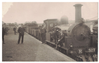 Linton and District Historical Society Inc
Postcard - Photograph, Steam Train, Linton Railway Station
Postcard which has a black and white image of a steam engine and carriages at Linton Railway Station. The R class engine was constructed at the Phoenix Foundry, Ballarat, between 1881 and 1886.Text, reverse: "Boy sitting on engine is Harold Morgan, man wearing bowler hat standing beside engine thought to be Mr Bourke, engine driver, father of Kitty and Lizzie. White house behind station master's cap, weatherboard cottage occupied by Mrs Howe, her daughter Myra and son Billy. Man on station wearing cap thought to be station master, Alec Thompson's father".linton railway station, steam engines, transport, railways -
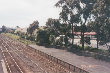 Sunbury Family History and Heritage Society Inc.
Photograph, 25th July 1995
The photograph of Sunbury Station was taken from the pedestrian bridge and is looking north to take in the Sunbury Square shopping centre buildings and the bus terminal which are on the Platform 1 or east side of the station.During the 1990s much development took place in Sunbury and the station precinct became a commercial hub.A coloured photograph of a railway station and a Coles Supermarket in the middle distance as well as a bus terminal. -
Stawell Historical Society Inc
Photograph, Stawell Police Station in Patrick Street 1991-92
New Stawell Police Station Building commenced March 1991 Patrick StreetColour photograph of New Police Station in Patrick Street March 1991stawell -
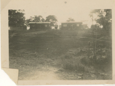 Lakes Entrance Historical Society
Photograph - Aboriginal Station Lake Tyers Victoria, 1/01/2024 12:00:00 AM
original cottages at Aboriginal Station Lake Tyers VictoriaBlack and white photograph of original cottages at Aboriginal Station Lake Tyers Victoriaaboriginal history, settlement -
 Kiewa Valley Historical Society
Photographs – SECV – Clover Power Station
The Junction Dam and Clover Dam Power Station, stages of the Kiewa Hydro-Electric Scheme, were needed to meet the increased power demands of the wartime industry in Victoria. Clover added 26 megawatts to the grid. Junction Dam was completed and ready to hold water by September 1943, but was emptied in December 1943 and not filled again until May 1944. Construction of Clover Power Station commenced in July 1941 and both turbines were in service by May 1945.Clover Power Station and Junction Dam were part of the Kiewa Hydro Electric Scheme constructed by the State Electricity Commission of VictoriaSet of black and white photographs taken by the official SECV photographer who gave each photo a number prefixed by K (for Kiewa) K1630- 23 Aug 1944 Clover Power Station K1633- no date Clover Power Station K1683- 10 Oct 1944 Weir K1700- no date Tail boy for Clover Power Station K1710- 11 Oct 1944 Part of aqueduct – Clover K1767- 6 Jan 1945 Switchboard in the power station K1769- 6 Jan 1945 Turbine and shaft K1770- 10 Jan 1945 Houses under construction at Bogong Village K1897- 22 Feb 1945 Equipment in the power station K1808- 22 Feb 1945 Equipment in the power station K1910- 31 May 1945 Top of the turbine and the shaft K1964- 16 Jul 1945 Equipment in the power station K1970- 17 Jul 1945 Bogong Village K1983- 30 Jul 1945 Turbine in power station K1984- 30 Jul 1945 Bogong Village K1989- 2 Aug 1945 Turbines in power station K1990- 2 Aug 1945 Equipment in power station K1991- 2 Aug 1945 Bogong village K2011- 28 Aug 1945 Equipment in power station K2015- 28 Aug 1945 Generators in power station K2016- 28 Aug 1945 Top of the turbine and the shaft K2018- 30 Aug 1945 Spiral casing, the turbine and the shaft On the back- each photograph has a handwritten reference number starting with K and the date stamped or writtensecv; kiewa hydro electric scheme; junction dam; clover power station; bogong -
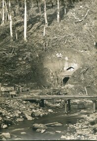
 Otway Districts Historical Society
Photograph, Banool Station, c.1940, c.1940
Originally known as "Moorbanool" after the local parish, the name was shortened to Banool on 1 November 1904. At first facilities consisted of a loop siding for eleven trucks and a passenger shelter, plus a residence for the ganger for the track gang based there. Increasing train services on the line required a crossing station in this section of track, so in 1913 Banool became a 'Staff & Ticket' station with a crossing loop, home signals, and a station office, although this only lasted two years. Loading statistics showed that in most years the outwards tonnage at Banool was less than 150 tonnes. From 1924 the amount of timber despatched began a slow rise, but apart from a few years activity was generally slack. The crossing loop, the usually empty goods loop being used if necessary, the home signals and its status as a staff station being removed over the period 1923-27. The track ganger shelter was removed around 1929 and the station reduced to a passenger shelter and goods loop only.B/W. A goods train passing Banool Station, c.1940. -
 Wodonga & District Historical Society Inc
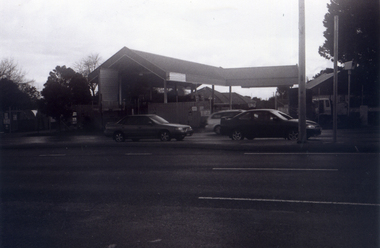
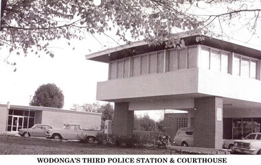
Photograph - Codling Collection 01 - Wodonga's 3rd Police Station and Court House
Miss Olive Codling was a Foundation Member and a Life Member of the Wodonga Historical Society. Many of her prize-winning photos are held in the Society Collection. She also held a range of roles and committee positions in a wide range of Wodonga community organisations. WODONGA's 3rd Police Station and Court House were constructed in Elgin Street, Wodonga. The Court House had to be relocated after the earlier building had been destroyed by a fire in 1964. In 1966, the new Wodonga Police Station was built but lay empty and idle for about three months. The reason given was that no furniture was available. After this situation was remedied the station was opened on December 23, 1966. The previous police station was vacated and pulled down. The new station was built in front of the new court house, which had been operating for approximately 12 months. The Police and Court House continued to operate on this site until they were again relocated in 2002. They are now located in Hovell Street, Wodonga.This photo collection is significant as it documents how the businesses and buildings in Wodonga have evolved and contributed to community throughout the 20th century.2 images of the 3rd police station built in Wodonga with the courthouse in the background.wodonga businesses, wodonga police station, wodonga court house -
Tatura Irrigation & Wartime Camps Museum
Photograph, Royal Visit Tatura 1954, 1954
Copy of photograph of Royal couple being greeted by dignitaries and station master Mr Kelly, at Tatura Railway Station 1954, before boarding train for Echuca. Black and white photograph of Queen and Duke of Edinburgh being greeted at Tatura Railway Station in 1954Royal Visit 1954royal visit 1954, queen elizabeth 2, duke of edinburgh, station master kelly, tatura railway station -
 Whitehorse Historical Society Inc.
Photograph, Nunawading Railway Station, 1/06/2009
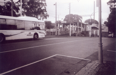
One of a collection of photographs taken of the Nunawading Railway Station prior to the lowering of the railway line and building of the new railway station on the western side of Springvale Road so that the Springvale Road Rail Crossing can be eliminated.Black & white photograph of he precinct surrounding the Nunawading Station and the Springvale Road Railway crossing. This photograph is of the southern entrance from Station Street. Note the Grenda Bus|See NP 3545 to NP3567for the complete set of photographsnunawading railway station, springvale road nunawading, redevelopment of railway line/springvale road., station street nunawading -
 Whitehorse Historical Society Inc.
Photograph, Nunawading Station - North Side, 1/06/2009
One of a collection of photographs taken of the Nunawading Railway Station prior to the lowering of the railway line and building of the new railway station on the western side of Springvale Road so that the Springvale Road Rail Crossing can be eliminated.Black & white photograph of he precinct surrounding the Nunawading Station and the Springvale Road Railway crossing. This photograph is of the Booking Office and Waiting Rooms on the North side of the Nunawading Station . See NP 3545 to NP3567 for the complete set of photographsnunawading railway station, springvale road nunawading, redevelopment of railway line/springvale road. -
 Kiewa Valley Historical Society
Photographs – SECV – Clover Power Station
The Junction Dam and Clover Dam Power Station, stages of the Kiewa Hydro-Electric Scheme, were needed to meet the increased power demands of the wartime industry in Victoria. Clover added 26 megawatts to the grid. Junction Dam was completed and ready to hold water by September 1943, but was emptied in December 1943 and not filled again until May 1944. Construction of Clover Power Station commenced in July 1941 and both turbines were in service by May 1945.Clover Power Station and Junction Dam were part of the Kiewa Hydro Electric Scheme constructed by the State Electricity Commission of Victoria.Set of 22 black and white photographs taken by the official SECV photographer who gave each photo a number prefixed by K (for Kiewa) K60 -no date- A bridge and entrance to tunnel K519 -no date- Welding steel lining in the tunnel K531 –no date- Construction on the Kiewa Scheme (tunnel in background K821 – no date- Bogong Village, early days K928 -15 Oct 1942- Construction Clover Power Station K947 -26 Oct 1942- Construction Clover Power Station K948 -26 Oct 1942- Construction Clover Power Station K949- 26 Oct 1942- Clover Camp in background K950 -26 Oct 1942- Construction Clover Power Station K955 -27 Oct 1942- Constructing the bridge at Clover K1102 -7 April 1943- Inlet pipe to power station K1179 –no date- Clover Power Station K1187 – no date- Clover Power Station K1189 -24 June 1943- Part of the spiral casing 1199 -7 July 1943- Clover Power Station K1201 -7 July 1943- Clover Power Station K1231 -26 July 1943- Gantry crane for Clover Power Station K1308 -6 Sept 1943- Spiral casing K1334 -6 Oct 1943- Lake Guy. Bogong Village in background K1342 -29 Oct 1943- Power station under construction K1365 -19 Nov 1943- Power station under construction K1366 -19 Nov 1943- Gantry crane for Clover Power Station On the back- each photograph has a handwritten reference number starting with K and the date stamped or written (see above)secv; kiewa hydro electric scheme; official photographer; junction dam; clover power station; bogong; -
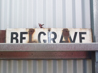 Puffing Billy Railway
Station Sign - Belgrave
Belgrave railway station is the terminus of the electrified line from Melbourne in Victoria, Australia, serving the eastern Melbourne suburb of Belgrave. Opened as Monbulk on 18 December 1900, it was renamed Belgrave on 21 November 1904. It was upgraded to a Premium station on 2 July 1996. The station was originally on the Upper Ferntree Gully – Gembrook narrow gauge line. It, along with the rest of the line, officially closed on 30 April 1954. However it saw further use between 1955 and early 1958, when trains were operated by the Puffing Billy Preservation Society in co-operation with the Victorian Railways. The station area re-opened on 19 February 1962 when the line as far as Belgrave was converted to broad gauge and used electric traction as part of the suburban network.[1] It has one island platform with two faces. It is serviced by Metro Trains' Belgrave line services The Puffing Billy Railway Belgrave station is located 100 metres north of the station and is accessible via a short footpath. It was required to be located further down the line than the original narrow-gauge station (which was approximately where the current suburban station car park is located). ref: https://en.wikipedia.org/wiki/Belgrave_railway_station photos at http://www.vicrailstations.com/Gembrook/Belgrave/Belgrave.htmlHistoric - Victorian Railways Station sign used at Belgrave StationStation Sign - Belgrave Metal sign - white enamel back ground with black letters Belgravepuffing billy, victorian railways, belgrave station -
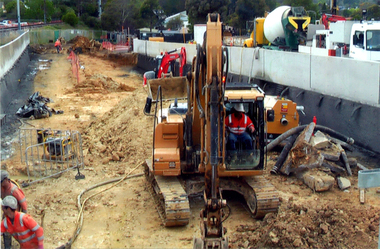
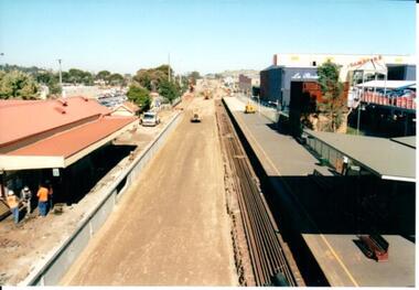 Hume City Civic Collection
Photograph, 21/04/2005
This photograph was taken during the upgrade of the Bendigo Railway line at Sunbury Station.A coloured photograph of construction on the site of the Sunbury Railway Station. The rail track has been lowered and the station platform has been narrowed to accommodate the new trains. The former bluestone wall below the platform on the Melbourne side of the station has been replaced by reinforced concrete. The rail lines have been placed along the track on the RHS of the photograph.railways, bendigo line, railway stations, bridges, sunbury railway station, george evans collection