Showing 521 items
matching studley
-
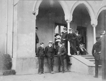 Mission to Seafarers Victoria
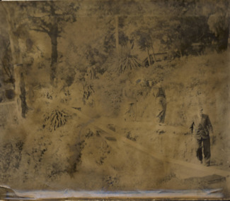
Photograph, Seamen standing in front of the house - Findon, Kew
This house is probably "Findon", Studley Park in Kew, belonging to Mrs Aubrey Bowen, widow of eye surgeon Thomas Aubrey Bowen (1837-1893). She welcomed large groups of seamen (up to 125) for Boxing Day at least on three consecutive years in 1906, 1907, 1908. Small monochrome photograph (faded) depicting outdoor gathering of seamen in front of a building with arches at one of the summer venues.findon, mrs aubrey bowen, thomas aubrey bowen, boxing day, kew, studley park -
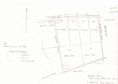 Whitehorse Historical Society Inc.
Document, Subdivisions 1859, nd
Sketch map of subdivisions of 1859.Sketch map of subdivisions of 1859. Allotment 126 and portions of 125, 126 and 130, including 'Village of Studley', 'Village of New Brunswick' and two unnamed. Information from Mr McComb, retired surveyor; sketch and notes. Areas near railway line east of Mitcham Station and North East corner of Canterbury and Mitcham Roads. Refer map A - SP 110.Sketch map of subdivisions of 1859.land subdivision, heatherdale road, mitcham, purches street, mitcham road, vermont, canterbury road, whitehorse road, brunswick road, creek road, centre road, studley village, new brunswick village -
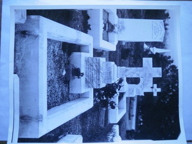 Glen Eira Historical Society
Photograph - Cantala
An unattributed, undated black and white photograph (205mm x 255mm) of the grave of Ernest George Miller and his mother Elizabeth Anne Miller. They are possibly the mother and brother of Septimus Miller, owner of Cantala. The location and cemetery is unknown. The photograph is from the Everard Studley Miller Collection, Royal Historical Society of Victoria.miller elizabeth anne, miller ernest george, miller everard studley, cemeteries, monuments and memorials, tombstones, photographs, cantala, miller septimus -
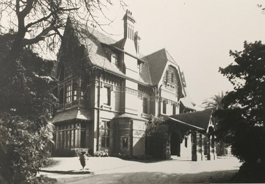 Kew Historical Society Inc
Photograph - 'Tara Hall', Studley Park Road, 1890-1900
During construction, commentators described the house as being in the ‘Elizabethan style’. The architectural style of the exterior, with its innovatory use of red brick and Italian tiles was more influenced by American models. Edward George Kilburn, of Ellerker & Kilburn, designed Byram for the industrialist George Ramsden in 1888.This is an original small photograph of this historic Kew mansion with provenance by descent from the first owners of the house.The main entrance to Tara Hall (previously named Byram, Goathland and Lowan). The entrance, through a porte-cochère, was located on the east side of the house. Inscription reverse: KH-323 Tara Hall once stood on Studley Pk Road on vast landscaped gardens. Donated by Mr Peter Ramsden, 49 Kamilaroy Road, West Pymble 2073 N.S.W. Dec.1979."byram, tara hall, lowan, goathland, edward g. kilburn (architect), george ramsden -
 Kew Historical Society Inc
Archive (Sub-series) - Subject File, Field Place (Kew), 1981
Various partiesReference, Research, InformationSecondary Values (KHS Imposed Order)Subject file containing photographs, a newspaper article/clipping, correspondence and a report by the Society to the Historic Buildings Preservation Council (HBPC) into the classification or otherwise of Field Place, the home of Francis Henty in Studley Park Road, and now entered via Henty Court. The HBPC file contains a letter from the current owner expressing what he considers to be its heritage significance. kew (vic) - history, francis henty, field place - studley park road - henty court (kew)kew (vic) - history, francis henty, field place - studley park road - henty court (kew) -
Kew Historical Society Inc
Archive (Sub-series) - Subject File, Kew Historical Society, HOWARD family, 1970
Various partiesReference, Research, InformationSecondary Values (KHS Imposed Order)The subject file contains a single 3-page document donated by Mr A Atkyns containing his research on the Howard family of United Kingdom and Australia. The main point of interest in the file is the references to Frederick William Howard who was an early landowner in Studley Park, in Kew. The file also lists the marriages of Howard children into other families such as the Cussens. The file includes a brief family tree.kew historical society - archives, kew - history, charles howard (1796-?), ship - sir godfrey webster, ship - james watt, howardville - preston (vic), elizabeth bennett, sarah pierce (?-1877), patrick e cussen, charles james howard, helen mcpherson, frederick william howard, kate alsop, amelia howard, rowland macarthur, edward cussen ormond howard, margaret alsop, anne howard, john alsop, emma sarah howard, edward augustus atkynskew historical society - archives, kew - history, charles howard (1796-?), ship - sir godfrey webster, ship - james watt, howardville - preston (vic), elizabeth bennett, sarah pierce (?-1877), patrick e cussen, charles james howard, helen mcpherson, frederick william howard, kate alsop, amelia howard, rowland macarthur, edward cussen ormond howard, margaret alsop, anne howard, john alsop, emma sarah howard, edward augustus atkyns -
 Kew Historical Society Inc
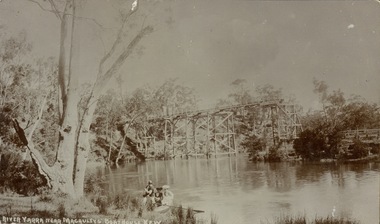
Postcard, River Yarra near Macauleys' Boathouse Kew
Sepia postcard of the Zig-zaf Bridge joining Yarra Bend and Studley Park. In the foreground is a rowboat in which a man is standing, behind whom are two women in hats and a young child. The man appears to be pushing the boat away from the Bank. In the distance is the wooden Zig-Zag Bridge, constructed in the 1870s to link the Yarra Bend and Kew Lunatic Asylums. [Destroyed by flood, 1929.]Obverse: "River Yarra near Macauleys' Boathouse Kew". Reverse: "Zig Zag Bridge / Gift from L Bennett 1980 / Bridge between Old Asylum & new Mental Hosp. / Kew side"zig-zag bridge -- kew (vic.), bridges -- river yarra, bridges -- kew (vic.) -
 Kew Historical Society Inc
Photograph, J F C Farquhar, Bird's Eye View Looking West, 1891
At the beginning of the 1890s, the Kew businessman and Town Councillor, Henry Kellett, commissioned J.F.C. Farquhar to photograph scenes of Kew. These scenes included panoramas as well as pastoral scenes. The resulting set of twelve photographs was assembled in an album, Kew Where We Live, from which customers could select images for purchase.The preamble to the album describes that the photographs used the ‘argentic bromide’ process, now more commonly known as the gelatine silver process. This form of dry plate photography allowed for the negatives to be kept for weeks before processing, hence its value in landscape photography. The resulting images were considered to be finely grained and everlasting. Evidence of the success of Henry Kellett’s venture can be seen today, in that some of the photographs are held in national collections.It is believed that the Kew Historical Society’s copy of the Kellett album is unique and that the photographs in the book were the first copies taken from the original plates. It is the first and most important series of images produced about Kew. The individual images have proved essential in identifying buildings and places of heritage value in the district.Before true aerial photography became possible, photographers such as J.F.C. Farquhar were compelled to shoot their images from the highest vantage point. Here, it is presumed to be the roof of Xavier College, from which the panoramic view extends west towards the rise of Studley Park. The houses in the foreground face the southern end of Gellibrand Street. Wellington Street is at an angle to the camera with the Queen Street intersection on the near right. The wooden building behind the large horse paddock on the other side of Gellibrand Street is the Kew Recreation Hall, built 1888, demolished 1960. It was reputed to have one of the finest dancing floors in or around Melbourne. The Bowling Green at the rear of the Hall belonged to the Kew Bowling Club. Further west is the Kew Railway Station on Denmark Street, opened to the public in 1887. At this period, much of Studley Park was locked up in large landholdings, dominated by large mansions such as ‘Byram’. Bird's Eye View Looking Westkew illustrated, kew where we live, photographic books, henry kellett, denmark street, kew recreation hall, kew bowling club, wellington street -
 Kew Historical Society Inc
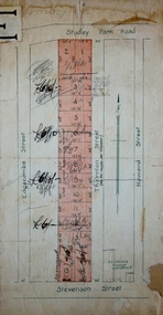
Plan - Subdivision Plan, Thornton Estate, 1918
The ‘Thornton Estate’ was the final subdivision of ‘Thornton’ in Studley Park Road. Thomas Cubitt Balmain originally owned Thornton, next to John Carson’s ‘Clutha’. Before its final subdivision, the Thomson family owned it. The Estate was a subdivision of 15 residential allotments running between Studley Park Road and Stevenson Street. The allotments faced these streets as well as Thornton Street, which the vendor undertook to make. Contemporary newspaper advertisements advised that ‘The estate possesses many advantages, notably its private and secluded, though convenient, position, splendid frontages and depths, and being close to the electric tram and Kew train, also within easy walking distance of the Victoria-street cable tram’. The terms offered purchasers were ten per cent deposit, with the balance to be paid in ten equal half-yearly payments at a rate of 5 per cent.subdivsion plans - kew, studley park, thornton estate -
Kew Historical Society Inc
Archive (Sub-series) - Subject File, Bowling Clubs, 1958
Various partiesReference, Research, InformationKHS OrderSubject file containing correspondence relating to the former Studley Park Bowling Club in Barry Street, Kew and its relocation to Yarra Bend Park. The file includes a photocopy of the letter by Nigel Lewis to the City of Kew, describing the historic importance of the Club (established c.1903) and the necessity of moving it before demolition. The file has information relating to the pavilion’s move and restoration as an art centre. [ KHS also holds the complete archives of the Auburn Heights Recreation Club (1904-98), the Kew Bowling Club (1880-1998) and the Kew Heights Sports Club (1998-2012). These are separate archives in Provenance Order].sports clubs - kew (vic.), studley park bowling club, urban conservation, heritage protectionsports clubs - kew (vic.), studley park bowling club, urban conservation, heritage protection -
 Kew Historical Society Inc
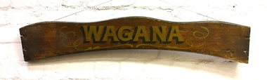
Sign, Wagana, 1920s
In the 1920s and 30s, rowing on the Yarra was a very popular weekend pastime. Each of the early boats was individually named in gold letters on its varnished wooden backboard. This is all that remains of one of the Thames pulling boats from Burns' Boatshed at Studley Park which was destroyed by a falling tree in a storm. Their entire fleet of rowing boats has now been replaced by fiberglass boats.Varnished wooden backplate of a rowing boat. The shaped sign is embossed with the name 'Wagana" in gold lettering, outlined and shaded in black paint. Gilt scroll work surrounds the name. The ends of the backplate shows the holes where the plate was once attached to the seat of the boat. The name Wagana means 'to dance' in Wiradjuri language."Wagana"burns' boatshed, thames pulling boats, yarra river -- kew (vic.), boathouses - river yarra -
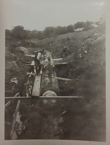
 Kew Historical Society Inc
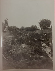
Photograph, City of Kew, Cecil Street Drain, 1936
An original photograph donated to the Kew Historical Society by the City's Engineering Department preceding the amalgamation of Kew into the City of Boroondara. While not all of the photographs are of Studley Park, Kew or East Kew, each photo provides a fine snapshot of the work of local government engineering departments of the period. They reveal they types of labour conducted, the techniques used and the equipment and machinery in the possession of the local government authority. Historic and rare photograph of major public works in Kew in the 1930sPublic works. Men at work in the creek bed of Connor's Creek in Kew, while constructing the underground barrel drain. Connors Creek was one of the two main tributaries of the Yarra River in Kew. It originated somewhere near the grounds of Genazzano FCJ College. The barrel drain was finally completed in 1941 at a cost of £14,000. Inscription on reverse: "City of Kew / Cecil st drain / November 1936". public works (kew), roadmaking, engineering, city of kew (engineering department), connor's creek (kew), cecil street drain -
 Kew Historical Society Inc
Photograph, City of Kew, Cecil Street Drain, 1936
An original photograph donated to the Kew Historical Society by the City's Engineering Department following the amalgamation of Kew into the City of Boroondara. While not all of the photographs are of Studley Park, Kew or East Kew, each photo provides a fine snapshot of the work of local government engineering departments of the period. They reveal they types of labour conducted, the techniques used and the equipment and machinery in the possession of the local government authority. Historic and rare photograph of major public works in Kew in the 1930s.Public works. Men at work in the creek bed of Connor's Creek in Kew, while constructing the underground drain. Connor's Creek was one of the two main tributaries of the Yarra River in Kew. It originated somewhere near the grounds of Genazzano FCJ College. The barrel drain was finally completed in 1941 at a cost of £14,000. Inscription on reverse: "City of Kew / Cecil st drain / November 1936". city of kew, city of kew (engineering department), engineering, connor's creek (kew) -
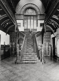 Kew Historical Society Inc
Photograph - Grand Staircase, Tara Hall', Studley Park Road, Marc Strizic (attrib), c.1960
'Lost Glories: a memorial to forgotten Australian buildings' was published by David Latta in 1986. It tells the story of a number of significant Australian buildings that had previously been demolished. A chapter in the book was devoted to Goathland, later known as Tara Hall. To supplement the text, he sourced photographs from a range of suppliers, chiefly the Royal Women's Hospital which had once owned Tara Hall, but had sold it in 1960. This is one of the photographs donated to KHS by the author. The Grand Staircase of Tara Hall, circa 1957. The central hallway and stairs of Tara Hall, (previously named Byram, Goathland and Lowan). Edward George Kilburn, of Ellerker & Kilburn, designed this Studley Park Road mansion, of which the hallway was a significant feature, for the industrialist George Ramsden in 1888. Tara Hall, one of the great houses in Kew was demolished in 1959-60. Possibly Marc Strizic, photographer (1928-2012). Typed inscription on reverse: "The Grand Staircase of Tara Hall (Royal Women's Hospital, Melbourne).byram, goathland, tara hall, lowan, studley park (kew), george ramsden, sir malcolm mceacharn, edward george kilburn (architect), studley park road (kew) -
 Kew Historical Society Inc
Plan - Subdivision Plan, Myrtle Park Estate, City of Camberwell, 1916
The Kew Historical Society collection includes almost 100 subdivision plans pertaining to suburbs of the City of Melbourne. Most of these are of Kew, Kew East or Studley Park, although a smaller number are plans of Camberwell, Deepdene, Balwyn and Hawthorn. It is believed that the majority of the plans were gifted to the Society by persons connected with the real estate firm - J. R. Mathers and McMillan, 136 Cotham Road, Kew. The Plans in the collection are rarely in pristine form, being working plans on which the agent would write notes and record lots sold and the prices of these. The subdivision plans are historically significant examples of the growth of urban Melbourne from the beginning of the 20th Century up until the 1980s. A number of the plans are double-sided and often include a photograph on the reverse. A number of the latter are by noted photographers such as J.E. Barnes.The ‘Myrtle Park Estate’ was a subdivision bounded by Victoria Road (now Lansdowne Street), Buchanan Avenue and Dight Avenue. Other streets that were created by the subdivision included Eurolie Street, Boorahman Street and Moody Street (now Sylvan Street). The Estate took its name from Myrtle Park (later changed to Macleay Park), which had been created in 1923 by Camberwell Council. The Park adjoined the southeast corner of the new subdivision. The Estate included 74 regular allotments characterised by narrow frontages and long blocks. Confusion may have greeted prospective purchasers as the Estate was advertised in the daily newspapers as being in East Kew, rather than in Camberwell, where it was at that stage located.subdivision plans - balwyn, myrtle park estate - camberwell [surrey hills] -
 Kew Historical Society Inc
Plan - Subdivision Plan, Central Park Estate, Deepdene - Camberwell, 1923
The Kew Historical Society collection includes almost 100 subdivision plans pertaining to suburbs of the City of Melbourne. Most of these are of Kew, Kew East or Studley Park, although a smaller number are plans of Camberwell, Deepdene, Balwyn and Hawthorn. It is believed that the majority of the plans were gifted to the Society by persons connected with the real estate firm - J. R. Mathers and McMillan, 136 Cotham Road, Kew. The Plans in the collection are rarely in pristine form, being working plans on which the agent would write notes and record lots sold and the prices of these. The subdivision plans are historically significant examples of the growth of urban Melbourne from the beginning of the 20th Century up until the 1980s. A number of the plans are double-sided and often include a photograph on the reverse. A number of the latter are by noted photographers such as J.E. Barnes.An agent’s board on which parts of an advertisement for the Central Park Estate have been pasted. [The State Library of Victoria holds a complete plan]. Whereas the original plan included black and white photographs and effusive prose about the virtues of the Estate, the item in our collection includes only the actual blocks. The agent has annotated particular blocks to indicate that they have been sold.subdivision plans - deepdene - camberwell, central park estate -
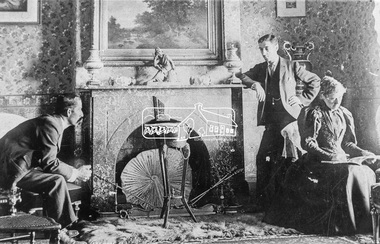 Eltham District Historical Society Inc
Photograph, Interior of Saxam, Greensborough, 1896. Seated are Mr and Mrs Kaye. Standing is William Stanton
Photo from G. Studley reproduced on p80 of The Diamond Valley Story by Dianne H. Edwards, Shire of Diamond Valley 1979. "Interior of Saxam, Greensborough, 1896. Seated are Mr and Mrs Kaye. Standing is William Stanton, local footballer, councillor and later Mayor of Heidelberg. A Greensborough street is named after him. The house still remains and is now in the grounds of Churinga, Diamond Creek Road."Black and white copy of photo printed on glossy photographic paper 30.5 x 40.5 cm (12 x 16 inch); image size approx. 18.5 x 28 cmchuringa, diamond creek road, diamond valley story, fireplace, greensborough, groups, mr kaye, mrs kaye, saxam, william stanton -
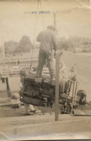 Kew Historical Society Inc
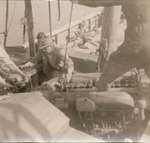
Photograph - Hicks Bros Motor Launch, circa 1953
This is one of a series of 17 black and white undated photographic proofs donated to the Kew Historical Society in 2013 by the Queenscliffe Historical Museum. The series includes images of individuals, tea rooms, ferries, motor launches, ocean liners and tugs. The subject of the photograph is a Hicks Bros ferry, which from circa 1921 operated a ferry service from Princess Walk (Melbourne) to Studley Park.Faded black and white photographic positive proof of a worker or employee standing on an engine as it is being lifted towards a Hicks Bros launch (tourist ferry) which is docked in an unidentified location. The undated photographic positive was probably taken in the 1950s.melbourne, motor launches, ferries, hicks bros, boat engines -
 Kew Historical Society Inc
Photograph - Men on the bank of the Yarra River, circa 1953
This is one of a series of 17 black and white undated photographic proofs donated to the Kew Historical Society in 2013 by the Queenscliffe Historical Museum. The series includes images of individuals, tea rooms, ferries, motor launches, ocean liners and tugs. The subject of the photograph is a Hicks Bros ferry, which from circa 1921 operated a ferry service from Princess Walk (Melbourne) to Studley Park.Very faded and degraded photograph of a group of men walking down pathways on the bank of a river in Melbourne. The location may be the Hawthorn Tea Rooms. The undated photographic positive was probably taken in the 1950s.melbourne, tourism -
 Kew Historical Society Inc
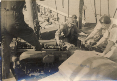
Photograph - Installing an engine on a Hicks Bros Motor Launch, circa 1953
This is one of a series of 17 black and white undated photographic proofs donated to the Kew Historical Society in 2013 by the Queenscliffe Historical Museum. The series includes images of individuals, tea rooms, ferries, motor launches, ocean liners and tugs. The subject of the photograph is a Hicks Bros ferry, which from circa 1921 operated a ferry service from Princess Walk (Melbourne) to Studley Park.Faded black and white photographic positive proof of a men attempting to install an engine in a Hicks Bros launch (tourist ferry). The undated photographic positive was probably taken in the 1950s.melbourne, motor launches, ferries, hicks bros, boat engines -
 Kew Historical Society Inc
Plan - Subdivision Plan, J R Mathers & McMillan, Clutha Subdivision, 1940
Pru Sanderson, in her groundbreaking ‘City of Kew Urban Conservation Study : Volume 2 - Development History’ (1988), summarised the periods of urban development and subdivisions of land in Kew. The periods that she identified included 1845-1880, 1880-1893, 1893-1921, 1921-1933, 1933-1943, and Post-War Development. These periods were selected as they represented periods of rapid growth or decline in urban development. An obvious starting point for Sanderson’s groupings involved population growth and the associated economic cycles. These cycles also highlighted urban expansion onto land that was predominantly rural, although in other cases it represented the decline and breakup of large estates. A number of the plans in the Kew Historical Society’s collection can also be found in other collections, such as those of the State Library of Victoria and the Boroondara Library Service. A number are however unique to the collection.The Kew Historical Society collection includes almost 100 subdivision plans pertaining to suburbs of the City of Melbourne. Most of these are of Kew, Kew East or Studley Park, although a smaller number are plans of Camberwell, Deepdene, Balwyn and Hawthorn. It is believed that the majority of the plans were gifted to the Society by persons connected with the real estate firm - J. R. Mathers and McMillan, 136 Cotham Road, Kew. The Plans in the collection are rarely in pristine form, being working plans on which the agent would write notes and record lots sold and the prices of these. The subdivision plans are historically significant examples of the growth of urban Melbourne from the beginning of the 20th Century up until the 1980s. A number of the plans are double-sided and often include a photograph on the reverse. A number of the latter are by noted photographers such as J.E. Barnes.The subdivision plan for the Clutha Subdivision is one of the largest in the Society’s collection. The plan includes a map of the proposed allotments, photographic views to the north and south, and information about the kinds of buildings that could be constructed on the allotments. The subdivision was bounded by Studley Park Road, and Carson, Stevenson and Edgecombe Streets. Two new streets, Mackie Court and Younger Street were created as part of the subdivision. The subdivision took its name from ‘Clutha’, the home of John Carson, who was to become Mayor of Kew in 1863. A Report to the City of Boroondara outlined how: ‘The Clutha estate was progressively developed from 1940, with new houses under construction on the Studley Park Road, Carson and Edgecombe Street frontages by 1941. By 1943, directory listings were available for all addresses with the exception of Mackie Court. Building ceased after the government’s prohibition on civilian building was enforced from 1942, with little change in listings until the 1950s when the remainder of the subdivision was developed’."H"subdivisions - kew - studley park, clutha subdivision, studley park road -
 Melbourne Tram Museum
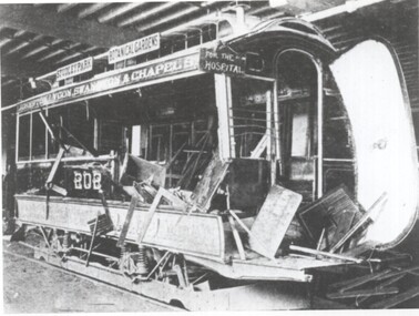
Photograph - Cable tram trailer 202 after a bad accident, 1890s
Photograph of cable tram trailer 202 after a bad accident where the side of the vehicles has been very badly damaged. The tram has a sign "for the hospital' attached to it. Destination signs are Studley Park, Botanical Gardens, Johnston St, Lygon St, Swanston St and Chapel St. Photo appeared in an article on Melbourne cable trams published in 1896 in Street Railway Review - See item 6444Yields information about severity of damage to a cable tram trailer 1890s.Copy photograph - Cable tram trailer 202 after a bad accidentMelbourne “A bad wreck” – Trailer No. 202. Copy neg Mark Plummer collections ex late John Alfred collection. cable trams, tramways, accidents, nicholson st workshops, articles, tram 202, trams -
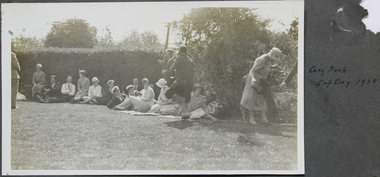 Mission to Seafarers Victoria
Photograph, Cosy Nook Cup Day 1928
Mr John Innerarity Buchan, Scottish real estate, and his wife. organised at least 4 known outings at their property - Finhaven - in Studley Park, Kew. Those parties were hosted for Cup Day in 1920, 1922, 1924 and 1928. Mr Buchan died in December 1922, but his wife continued with the tradition. The house was sold and demolished in 1941 to create several allotments around Finhaven Court.on page 13 (has been cut)mr john inerrarity buchan, finhaven, studley park, kew, cup day, 1928, fan album -
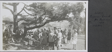 Mission to Seafarers Victoria
Photograph - Photograph, Black and White, Ladies preparing lunch Mrs Buchans 1928 Cup Day, November 1928
Mr John Innerarity Buchan, Scottish real estate, and his wife. organised at least 4 known outings at their property - Finhaven - in Studley Park, Kew. Those parties were hosted for Cup Day in 1920, 1922, 1924 and 1928. Mr Buchan died in December 1922, but his wife continued with the tradition. The house was sold and demolished in 1941 to create several allotments around Finhaven Court.on oage 13finhaven, mr john inerrarity buchan, cup day, studley park, kew, reverend john reginald weller (1880-1969), 1928, fan album -
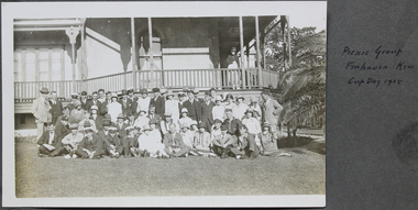 Mission to Seafarers Victoria
Photograph, Picnic group Finhaven Kew Cup Day 1928
Mr John Innerarity Buchan, Scottish real estate, and his wife. organised at least 4 known outings at their property - Finhaven - in Studley Park, Kew. Those parties were hosted for Cup Day in 1920, 1922, 1924 and 1928. Mr Buchan died in December 1922, but his wife continued with the tradition. The house was sold and demolished in 1941 to create several allotments around Finhaven Court.Group photograph of men and ladies skiing on the grass and standing in front of a house. Reverend Weller is sitting on the grass in the middle first row. on page 13 (page cut from fan album)Picnic group Finhaven Kew Cup Day 1928 on the album page finhaven, mr john inerrarity buchan, mrs buchan, cup day, reverend john reginald weller, 1928, fan album -
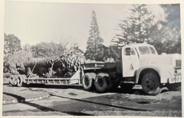
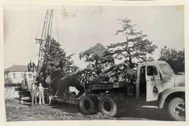 Kew Historical Society Inc
Photograph - Loading a palm tree from Tara Hall, Studley Park Road, c. 1960
Tom Bentley (1912-1993) was born in Lancashire (UK). From circa 1951, he was the Overseer/Superintendent of Outdoor Works for Kew City Council. Until his retirement in the 1970s, he was based at the Kew Council Depot, located in the former MTB Horse Tram Depot on the corner of Disraeli and High Streets, Kew. Accompanying the set of twelve photographs is a 12-page illustrated biography of the Bentley and Plumridge families, separately kept in the 'Bentley' subject file.Duplicate black and white positive print photograph of public works in Studley Park Road, Kew, carried out under the supervision of Tom Bentley, Overseer/Superintendent of Outdoor Works for the City of Kew. The location at which the photograph was taken is believed, by the donor, to be in the vicinity of Tara Hall (dem. 1960). The palm tree on the back of the Council vehicle was believed to have been taken by Council from Tara Hall and relocated to the Alexandra Gardens.city of kew, public works, studley park road, tom bentley, tara hall -
 Kew Historical Society Inc
Photograph - Transporting a palm tree from Tara Hall, Studley Park Road, c. 1960
Tom Bentley (1912-1993) was born in Lancashire (UK). From circa 1951, he was the Overseer/Superintendent of Outdoor Works for Kew City Council. Until his retirement in the 1970s, he was based at the Kew Council Depot, located in the former MTB Horse Tram Depot on the corner of Disraeli and High Streets, Kew. Accompanying the set of twelve photographs is a 12-page illustrated biography of the Bentley and Plumridge families, separately kept in the 'Bentley' subject file.Duplicate black and white positive print photograph of public works in Studley Park Road, Kew, carried out under the supervision of Tom Bentley, Overseer/Superintendent of Outdoor Works for the City of Kew. The location at which the photograph was taken is believed, by the donor, to be in the vicinity of Tara Hall (dem. 1960). The palm tree on the back of the Council vehicle was believed to have been taken by Council from Tara Hall and relocated to the Alexandra Gardens.city of kew, public works, studley park road, tom bentley, tara hall -
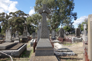 Kew Historical Society Inc
Photograph - Digital Photograph, Robert Baker, Grave of George Wharton, Boroondara General Cemetery, 2013
The Victorian-era architect George Wharton, the initial surveyor of Kew. In 1866, he designed and had built Fernhurst in Studley Park, the house a prominent landmark. He resided there until his death, aged 69, on 26 November 1891. He was buried on 27 November in Grave 1520, Church of England Compartment B, Boroondara General Cemetery. Fernhurst Grove is named after his house, which was demolished in 1979.Born digital image of the grave and headstone of the architect George Wharton in the Boroondara General (Kew) Cemetery, 2013. George Wharton created the first survey of Kew and was elected the Municipality's first Chairman in 1861.victorian architects - george wharton, chairmen of kew (vic) - george wharton, boroondara general (kew) cemetery -
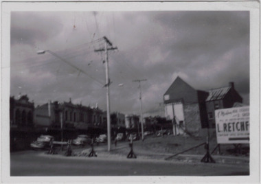 Kew Historical Society Inc
Photograph - Kew Junction during road widening, December 1958
Kew Junction is the intersection of five major roads - Denmark Street, High Street, High Street South, Studley Park Road and Princess Street. The original widening of High Street in the 1930s expanded that street by removing shops on the south side of the street from Cotham Road to Denmark Street. Further widening in 1958 removed shops at the west end of High Street to allow for increased traffic using Princes Street and Denmark Street.Original, black and white positive of Kew Junction, including the corner with Denmark Street during road widening in the 1958.Inscribed verso: "Kew Junction Dec 1958 / When the road was being widened by the removal of a number of shops / Notice saying Retchford's Estate agency's temporary office is at the top end of Denmark Street, Kew"kew junction, denmark street -- kew (vic.), major roadworks -- kew (vic.)