Showing 434 items matching "suburban street"
-
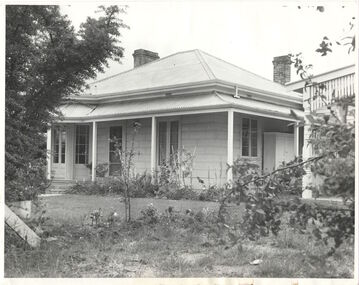
![Victorian era cottage, Derby Street [Kew]](/media/collectors/550653872162f11fb04854aa/items/658f5772101c4283c6ae47ff/item-media/658f57e4101c4283c6ae493a/item-fit-380x285.jpg) Kew Historical Society Inc
Kew Historical Society IncPhotograph - Victorian era cottage, Derby Street [Kew], c. 1965
The current site of the Kew Recreation Centre in High Street Kew previously housed the Kew Depot on the corner of Disraeli Street. In nearby Derby Street, a number of original Victorian era buildings were gradually replaced due to development of the Baths precinct and commercial development.This work forms part of the collection assembled by the historian Dorothy Rogers (1905-1973), donated to the Kew Historical Society by her son in 2015. The manuscripts, photographs, maps, and documents were sourced by her from both family and local collections or produced as references for her print publications. Many were directly used by Rogers in writing ‘Lovely Old Homes of Kew’ (1961) and 'A History of Kew' (1973), or the numerous articles on local history that she produced for suburban newspapers. Most of the photographs in the collection include detailed annotations in her hand. The Rogers Collection provides a comprehensive insight into the working habits of a historian from the 1960s to the 1970s. Small single fronted cottage in Derby Street, Kew. The weatherboard cottage has a block fronted facade, and a Victorian verandah with cast iron lace.Annotation verso: "House in Derby St., next to Kew Baths (Demolished?)"dorothy rogers, derby street (kew), victorian houses -- kew (vic.) -
 Kew Historical Society Inc
Photograph - Kew Recreation Hall, Wellington Street, c.1950
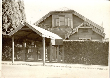
The Kew Recreation Hall was opened in 1880. For eighty years it was a major venue for concerts, performances, dances and civic events. It was demolished in 1960.This work forms part of the collection assembled by the historian Dorothy Rogers (1905-1973), donated to the Kew Historical Society by her son in 2015. The manuscripts, photographs, maps, and documents were sourced by her from both family and local collections or produced as references for her print publications. Many were directly used by Rogers in writing ‘Lovely Old Homes of Kew’ (1961) and 'A History of Kew' (1973), or the numerous articles on local history that she produced for suburban newspapers. Most of the photographs in the collection include detailed annotations in her hand. The Rogers Collection provides a comprehensive insight into the working habits of a historian from the 1960s to the 1970s. Front view, from Wellington Street, of the former Kew Recreation Hall. The 1880 weatherboard building has a long covered entrance leading to the gabled facade. A smaller gabled room protrudes from one side of the facade. At this stage, the decorative features: gables, brackets, finials, etc were still preserved. The triple window would have been a major source of light for the interior. It appears to have an upper balcony in front of the window. Annotation verso: "28. Kew Recreation Hall prior to demolition. Built about 1880."dorothy rogers, kew recreation hall, buildings -- wellington street (kew) -
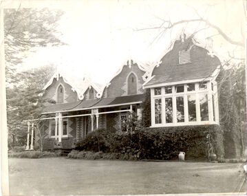
!['Ellesmere', Princess Street [Kew]](/media/collectors/550653872162f11fb04854aa/items/658f623d101c4283c6ae94cb/item-media/658f6272101c4283c6ae9580/item-fit-380x285.jpg) Kew Historical Society Inc
Kew Historical Society IncPhotograph - 'Ellesmere', Princess Street [Kew], c.1950
A National Trust (Vic) citation records that Ellesmore [sic] was: 'A late Victorian Villa in the grand manner but completed to a meaner standard in the Edwardian Period. Notable for the mannerist porticos surmounted by a sepulchre motif: the central vestibule at the intersection of the two major axes, with lantern lighting from above: and the art nouveau woodwork of the drawing room'.This work forms part of the collection assembled by the historian Dorothy Rogers (1905-1973), donated to the Kew Historical Society by her son in 2015. The manuscripts, photographs, maps, and documents were sourced by her from both family and local collections or produced as references for her print publications. Many were directly used by Rogers in writing ‘Lovely Old Homes of Kew’ (1961) and 'A History of Kew' (1973), or the numerous articles on local history that she produced for suburban newspapers. Most of the photographs in the collection include detailed annotations in her hand. The Rogers Collection provides a comprehensive insight into the working habits of a historian from the 1960s to the 1970s. Faded monochrome snapshot of 'Ellesmere'Annotation verso: "Porch of Ellesmere"dorothy rogers, ellesmere -- princess street -- kew (vic), houses -- princess street (kew) -
 Kew Historical Society Inc
Photograph - Kew Recreation Hall, Wellington Street, c.1950
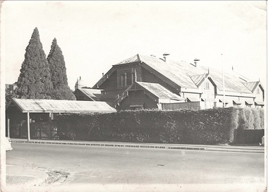
The Kew Recreation Hall was opened in 1880. For eighty years it was a major venue for concerts, performances, dances and civic events. It was demolished in 1960.This work forms part of the collection assembled by the historian Dorothy Rogers (1905-1973), donated to the Kew Historical Society by her son in 2015. The manuscripts, photographs, maps, and documents were sourced by her from both family and local collections or produced as references for her print publications. Many were directly used by Rogers in writing ‘Lovely Old Homes of Kew’ (1961) and 'A History of Kew' (1973), or the numerous articles on local history that she produced for suburban newspapers. Most of the photographs in the collection include detailed annotations in her hand. The Rogers Collection provides a comprehensive insight into the working habits of a historian from the 1960s to the 1970s. Oblique view, from Wellington Street, of the former Kew Recreation Hall. The 1880 weatherboard building has a long covered entrance leading to the gabled facade. A smaller gabled room protrudes from one side of the facade. At this stage, the decorative features: gables, brackets, finials, etc were still preserved. The triple window would have been a major source of light for the interior. It appears to have an upper balcony in front of the window. Annotation verso: "Kew Recreation Hall. Built ca. 1880 (Photo prior to demolition in 1960".dorothy rogers, kew recreation hall, buildings -- wellington street (kew) -
![Victorian era cottage, Gladstone Street [Kew]](/media/collectors/550653872162f11fb04854aa/items/658f6b449239cf6fd4368ae2/item-media/658f6b719239cf6fd4368bda/item-fit-380x285.jpg) Kew Historical Society Inc
Kew Historical Society IncPhotograph - Victorian era cottage, Gladstone Street [Kew], c. 1965
This work forms part of the collection assembled by the historian Dorothy Rogers (1905-1973), donated to the Kew Historical Society by her son in 2015. The manuscripts, photographs, maps, and documents were sourced by her from both family and local collections or produced as references for her print publications. Many were directly used by Rogers in writing ‘Lovely Old Homes of Kew’ (1961) and 'A History of Kew' (1973), or the numerous articles on local history that she produced for suburban newspapers. Most of the photographs in the collection include detailed annotations in her hand. The Rogers Collection provides a comprehensive insight into the working habits of a historian from the 1960s to the 1970s. Small single fronted cottage in Gladstone Street, Kew. The weatherboard cottage has a block fronted facade, and a Victorian verandah with cast iron lace.Annotation verso: "Mr Williams cottage in Gladstone St, Kew. He was Miss Louisa Henty's coachman. Hailed from West Indies. Built about 1900."dorothy rogers, victorian houses -- kew (vic.), houses -- gladstone street (kew), louisa henty, gardeners -- kew (vic.) -
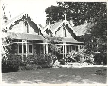
![Entrance hall ceiling , 'Villa Alba', Walmer Street [Kew]](/media/collectors/550653872162f11fb04854aa/items/658f7b159239cf6fd436bc33/item-media/658f7b569239cf6fd436bd23/item-fit-380x285.jpg) Kew Historical Society Inc
Kew Historical Society IncPhotograph - Entrance hall ceiling , 'Villa Alba', Walmer Street [Kew], c. 1965
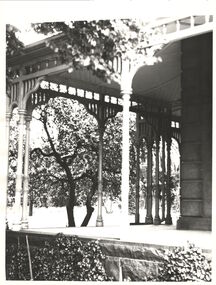
"Villa Alba is of significance for the outstanding late Victorian painted decoration throughout its interior. The consistently high standard of design in the decoration, and high, and at times, superb quality of its execution, the variety of illustrative techniques, the variety of illusionist effects and the hierarchy of treatments between the rooms of the house all contribute to the significance. The decorative scheme is also of significance as a fine example of the work of the leading Melbourne decorators, the Paterson Brothers. It is one of their first interiors to depart totally from the use of pre-prepared wallpapers of repetitive designs and it is a rare and comprehensive extant example of their domestic work. The decorative schemes in the ground floor hall, the dining room, the drawing, the vestibule, the stair hall, the upper hall, bedroom 1 and the boudoir are also individually of significance as outstanding examples of Victorian decoration.." (Victorian Heritage Database, 2023)This work forms part of the collection assembled by the historian Dorothy Rogers (1905-1973), donated to the Kew Historical Society by her son in 2015. The manuscripts, photographs, maps, and documents were sourced by her from both family and local collections or produced as references for her print publications. Many were directly used by Rogers in writing ‘Lovely Old Homes of Kew’ (1961) and 'A History of Kew' (1973), or the numerous articles on local history that she produced for suburban newspapers. Most of the photographs in the collection include detailed annotations in her hand. The Rogers Collection provides a comprehensive insight into the working habits of a historian from the 1960s to the 1970s. Original print monochrome photograph of a section of the entrance hall ceiling in 'Villa Alba', Walmer Street (Kew)Annotation verso: "Villa Alba, Walmer Street (Kew)"dorothy rogers, villa alba museum, paterson bros, interior decoration -- 1880s -
![Ceiling , 'Villa Alba', Walmer Street [Kew]](/media/collectors/550653872162f11fb04854aa/items/658f7c189239cf6fd436c0b0/item-media/658f7c3f9239cf6fd436c4d4/item-fit-380x285.jpg) Kew Historical Society Inc
Kew Historical Society IncPhotograph - Ceiling , 'Villa Alba', Walmer Street [Kew], c. 1965
"Villa Alba is of significance for the outstanding late Victorian painted decoration throughout its interior. The consistently high standard of design in the decoration, and high, and at times, superb quality of its execution, the variety of illustrative techniques, the variety of illusionist effects and the hierarchy of treatments between the rooms of the house all contribute to the significance. The decorative scheme is also of significance as a fine example of the work of the leading Melbourne decorators, the Paterson Brothers. It is one of their first interiors to depart totally from the use of pre-prepared wallpapers of repetitive designs and it is a rare and comprehensive extant example of their domestic work. The decorative schemes in the ground floor hall, the dining room, the drawing, the vestibule, the stair hall, the upper hall, bedroom 1 and the boudoir are also individually of significance as outstanding examples of Victorian decoration.." (Victorian Heritage Database, 2023)This work forms part of the collection assembled by the historian Dorothy Rogers (1905-1973), donated to the Kew Historical Society by her son in 2015. The manuscripts, photographs, maps, and documents were sourced by her from both family and local collections or produced as references for her print publications. Many were directly used by Rogers in writing ‘Lovely Old Homes of Kew’ (1961) and 'A History of Kew' (1973), or the numerous articles on local history that she produced for suburban newspapers. Most of the photographs in the collection include detailed annotations in her hand. The Rogers Collection provides a comprehensive insight into the working habits of a historian from the 1960s to the 1970s. Original print monochrome photograph of a section of a ceiling in 'Villa Alba', Walmer Street (Kew)Annotation verso: "Villa Alba, Walmer Street (Kew)"dorothy rogers, villa alba museum, paterson bros, interior decoration -- 1880s -
!['Ellesmere', Princess Street [Kew]](/media/collectors/550653872162f11fb04854aa/items/658f7d279239cf6fd436c92f/item-media/658f7d3a9239cf6fd436c99a/item-fit-380x285.jpg) Kew Historical Society Inc
Kew Historical Society IncPhotograph - 'Ellesmere', Princess Street [Kew], c.1950
A National Trust (Vic) citation records that Ellesmore [sic] was: 'A late Victorian Villa in the grand manner but completed to a meaner standard in the Edwardian Period. Notable for the mannerist porticos surmounted by a sepulchre motif: the central vestibule at the intersection of the two major axes, with lantern lighting from above: and the art nouveau woodwork of the drawing room'.This work forms part of the collection assembled by the historian Dorothy Rogers (1905-1973), donated to the Kew Historical Society by her son in 2015. The manuscripts, photographs, maps, and documents were sourced by her from both family and local collections or produced as references for her print publications. Many were directly used by Rogers in writing ‘Lovely Old Homes of Kew’ (1961) and 'A History of Kew' (1973), or the numerous articles on local history that she produced for suburban newspapers. Most of the photographs in the collection include detailed annotations in her hand. The Rogers Collection provides a comprehensive insight into the working habits of a historian from the 1960s to the 1970s. Monochrome snapshot of the verandah of 'Ellesmere'Annotation verso: "Ellesmere. Princess Street. Now Presbyterian Girls Hostel"dorothy rogers, ellesmere -- princess street -- kew (vic), houses -- princess street (kew) -
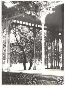
!['Ellesmere', Princess Street [Kew]](/media/collectors/550653872162f11fb04854aa/items/658f7dce9239cf6fd436cd00/item-media/658f7de99239cf6fd436cd7c/item-fit-380x285.jpg) Kew Historical Society Inc
Kew Historical Society IncPhotograph - 'Ellesmere', Princess Street [Kew], c.1950
A National Trust (Vic) citation records that Ellesmore [sic] was: 'A late Victorian Villa in the grand manner but completed to a meaner standard in the Edwardian Period. Notable for the mannerist porticos surmounted by a sepulchre motif: the central vestibule at the intersection of the two major axes, with lantern lighting from above: and the art nouveau woodwork of the drawing room'.This work forms part of the collection assembled by the historian Dorothy Rogers (1905-1973), donated to the Kew Historical Society by her son in 2015. The manuscripts, photographs, maps, and documents were sourced by her from both family and local collections or produced as references for her print publications. Many were directly used by Rogers in writing ‘Lovely Old Homes of Kew’ (1961) and 'A History of Kew' (1973), or the numerous articles on local history that she produced for suburban newspapers. Most of the photographs in the collection include detailed annotations in her hand. The Rogers Collection provides a comprehensive insight into the working habits of a historian from the 1960s to the 1970s. Monochrome snapshot of the verandah of 'Ellesmere'Annotation verso: "Ellesmere. Princess Street. Now Presbyterian Girls Hostel"dorothy rogers, ellesmere -- princess street -- kew (vic), houses -- princess street (kew) -
 Kew Historical Society Inc
Photograph - Verandah of 'Ellesmere', Princess Street (Kew), c.1950
A National Trust (Vic) citation records that Ellesmore [sic] was: 'A late Victorian Villa in the grand manner but completed to a meaner standard in the Edwardian Period. Notable for the mannerist porticos surmounted by a sepulchre motif: the central vestibule at the intersection of the two major axes, with lantern lighting from above: and the art nouveau woodwork of the drawing room'.This work forms part of the collection assembled by the historian Dorothy Rogers (1905-1973), donated to the Kew Historical Society by her son in 2015. The manuscripts, photographs, maps, and documents were sourced by her from both family and local collections or produced as references for her print publications. Many were directly used by Rogers in writing ‘Lovely Old Homes of Kew’ (1961) and 'A History of Kew' (1973), or the numerous articles on local history that she produced for suburban newspapers. Most of the photographs in the collection include detailed annotations in her hand. The Rogers Collection provides a comprehensive insight into the working habits of a historian from the 1960s to the 1970s. Monochrome snapshot of the a section of the verandah of 'Ellesmere'Annotation verso: "Ellesmere, Princess Street (Kew)."dorothy rogers, ellesmere -- princess street -- kew (vic), houses -- princess street (kew) -
![Victorian era cottage, Derby Street [Kew]](/media/collectors/550653872162f11fb04854aa/items/658f7ef19239cf6fd436d1fd/item-media/658f7f019239cf6fd436d25f/item-fit-380x285.jpg) Kew Historical Society Inc
Kew Historical Society IncPhotograph - Victorian era cottage, Derby Street [Kew], c. 1965
The current site of the Kew Recreation Centre in High Street Kew previously housed the Kew Depot on the corner of Disraeli Street. In nearby Derby Street, a number of original Victorian era buildings were gradually replaced due to development of the Baths precinct and commercial development.This work forms part of the collection assembled by the historian Dorothy Rogers (1905-1973), donated to the Kew Historical Society by her son in 2015. The manuscripts, photographs, maps, and documents were sourced by her from both family and local collections or produced as references for her print publications. Many were directly used by Rogers in writing ‘Lovely Old Homes of Kew’ (1961) and 'A History of Kew' (1973), or the numerous articles on local history that she produced for suburban newspapers. Most of the photographs in the collection include detailed annotations in her hand. The Rogers Collection provides a comprehensive insight into the working habits of a historian from the 1960s to the 1970s. Small single fronted cottage in Derby Street, Kew. The weatherboard cottage has a block fronted facade, and a Victorian verandah with cast iron lace.dorothy rogers, derby street (kew), victorian houses -- kew (vic.) -
![Schoolmaster's house, Pakington Street [Kew]](/media/collectors/550653872162f11fb04854aa/items/658f92059239cf6fd4375312/item-media/658f92439239cf6fd43754a9/item-fit-380x285.jpg) Kew Historical Society Inc
Kew Historical Society IncPhotograph - Schoolmaster's house, Pakington Street [Kew], c. 1965
This work forms part of the collection assembled by the historian Dorothy Rogers (1905-1973), donated to the Kew Historical Society by her son in 2015. The manuscripts, photographs, maps, and documents were sourced by her from both family and local collections or produced as references for her print publications. Many were directly used by Rogers in writing ‘Lovely Old Homes of Kew’ (1961) and 'A History of Kew' (1973), or the numerous articles on local history that she produced for suburban newspapers. Most of the photographs in the collection include detailed annotations in her hand. The Rogers Collection provides a comprehensive insight into the working habits of a historian from the 1960s to the 1970s. Original monochrome photograph of the exterior of a polychrome brick Victorian villa in Pakington Street, Kew. The villa has a slate roof, two bay windows and a verandah.Inscribed verso: "ca. 1860 home of the 1st state school master (back of house only seen from Peel Street now)".dorothy rogers, houses -- pakington street (kew) -
 Kew Historical Society Inc
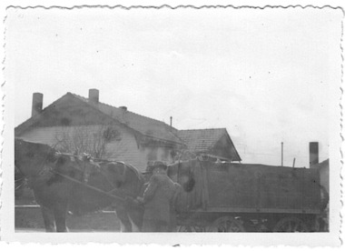
Photograph - Rubbish cart of the City of Kew, 1935-1945
The City of Kew (1860-1994) was a municipality within the boundaries of suburban Melbourne, bordering on the inner suburbs. It was governed by a Council who employed council officers and workers. Services offered to ratepayers included garbage collection. Workers also carried our rubbish removal. From the evidence of photographs, garbage trucks has a semi-circular top with openings on the side of the top and at the rear. Rubbish carts were simple open top containers. Both garbage trucks and rubbish carts were drawn by horses and, in the interwar years and after, operated out of the Council Depot in High Street (formerly the 'horse tramway' sheds and later was to be replaced by the Kew Recreation Centre. The depot was on the corner of High and Disraeli Streets, kew. Small, original black and white positive photograph of a council worker, horse and rubbish cart. This rectangular cart has an open top. An unidentified house is in the background.Annotation in pencil by donor verso: "Kew Council Rubbish cart / Pre & during WWII / from Eliz Bentley"rubbish collection, garbage collection, rubbish carts, city of kew, council workers, horse-drawn vehicles, kew depot -
 Kew Historical Society Inc
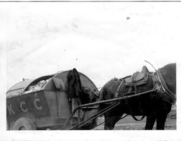
Photograph - City of Kew garbage truck, 1935-1945
The City of Kew (1860-1994) was a municipality within the boundaries of suburban Melbourne, bordering on the inner suburbs. It was governed by a Council who employed council officers and workers. Services offered to ratepayers included garbage collection. Workers also carried our rubbish removal. From the evidence of photographs, garbage trucks has a semi-circular top with openings on the side of the top and at the rear. Rubbish carts were simple open top containers. Both garbage trucks and rubbish carts were drawn by horses and, in the interwar years and after, operated out of the Council Depot in High Street (formerly the 'horse tramway' sheds and later was to be replaced by the Kew Recreation Centre. The depot was on the corner of High and Disraeli Streets, kew. Small, original black and white positive photograph of a City of Kew horse and garbage cart. The rectangular cart has a curved roof with openings at the side. A large door at the back allowed for the removal of garbage. K.C.C. is written on the side of the cart.Annotation in pencil by donor verso: "From E. Bennett / Kew City C'cil used during and after WW2 / from E. Bentley"rubbish collection, garbage collection, rubbish carts, city of kew, council workers, horse-drawn vehicles, kew depot -
 Kew Historical Society Inc
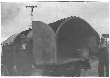
Photograph - City of Kew garbage cart, 1935-1945
The City of Kew (1860-1994) was a municipality within the boundaries of suburban Melbourne, bordering on the inner suburbs. It was governed by a Council who employed council officers and workers. Services offered to ratepayers included garbage collection. Workers also carried our rubbish removal. From the evidence of photographs, garbage trucks has a semi-circular top with openings on the side of the top and at the rear. Rubbish carts were simple open top containers. Both garbage trucks and rubbish carts were drawn by horses and, in the interwar years and after, operated out of the Council Depot in High Street (formerly the 'horse tramway' sheds and later was to be replaced by the Kew Recreation Centre. The depot was on the corner of High and Disraeli Streets, kew. Small, original black and white positive photograph of a City of Kew garbage cart and two council workers. The rectangular cart has a curved roof with openings at the side. A large door at the back allowed for the removal of garbage. Annotation in pencil by donor verso: "From E. Bentley / used during and after WW2 / Kew Garbage Truck"rubbish collection, garbage collection, rubbish carts, city of kew, council workers, horse-drawn vehicles, kew depot -
 Kew Historical Society Inc
Photograph - 'Mynda', 5 Molesworth Street, 1979
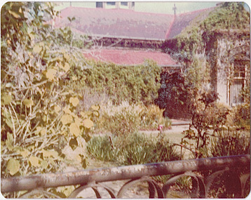
'A suburban villa of 1885 designed by Lloyd Tayler for his daughter and son-in-law on a plan centred upon an octagonal top-lit hall. A square bay window to the drawing room projects from the front corner of the house at 45 degress, showing for the first time the diagonal emphasis which was to be developed in other works of the architect and to become in due course a characteristic of the Federation Style.' (National Trust Victoria Citation)Original colour positive photograph (Kodak print) of the front garden of 'Mynda', 5 Molesworth Street, KewInk on reverse: "Miss Anderson's / No.5 Molesworth St. / Cottage garden / Taken and ***"historic gardens -- kew (vic.), mynda, 5 molesworth street -- kew (vic.) -
 Kew Historical Society Inc
Photograph, 'Roseneath', Pakington Street, c. 1960
This work forms part of the collection assembled by the historian Dorothy Rogers, that was donated to the Kew Historical Society by her son John Rogers in 2015. The manuscripts, photographs, maps, and documents were sourced by her from both family and local collections or produced as references for her print publications. Many were directly used by Rogers in writing ‘Lovely Old Homes of Kew’ (1961) and 'A History of Kew' (1973), or the numerous articles on local history that she produced for suburban newspapers. Most of the photographs in the collection include detailed annotations in her hand. The Rogers Collection provides a comprehensive insight into the working habits of a historian in the 1960s and 1970s. Together it forms the largest privately-donated collection within the archives of the Kew Historical Society.The front steps of Roseneath in Pakington Street, KewRoseneath. Dunn added Holy Dogs 1880sroseneath, dorothy rogers, pakington street, kew -
 Kew Historical Society Inc
Photograph, 'Roseneath', Pakington Street, c. 1960
This work forms part of the collection assembled by the historian Dorothy Rogers, that was donated to the Kew Historical Society by her son John Rogers in 2015. The manuscripts, photographs, maps, and documents were sourced by her from both family and local collections or produced as references for her print publications. Many were directly used by Rogers in writing ‘Lovely Old Homes of Kew’ (1961) and 'A History of Kew' (1973), or the numerous articles on local history that she produced for suburban newspapers. Most of the photographs in the collection include detailed annotations in her hand. The Rogers Collection provides a comprehensive insight into the working habits of a historian in the 1960s and 1970s. Together it forms the largest privately-donated collection within the archives of the Kew Historical Society.The facade of Roseneath in Pakington Street, Kew. A version of this photograph was used by Dorothy Rogers in 'A History of Kew' (1973). It faces page 96.Roseneathroseneath, pakington street, kew, dorothy rogers -
 Kew Historical Society Inc
Photograph, 'Ellesmere,' Princess Street, Kew, circa 1965, c. 1960
A National Trust (Vic) citation records that Ellesmore [sic] was: 'A late Victorian Villa in the grand manner but completed to a meaner standard in the Edwardian Period. Notable for the mannerist porticos surmounted by a sepulchre motif: the central vestibule at the intersection of the two major axes, with lantern lighting from above: and the art nouveau woodwork of the drawing room'.This work forms part of the collection assembled by the historian Dorothy Rogers, that was donated to the Kew Historical Society by her son John Rogers in 2015. The manuscripts, photographs, maps, and documents were sourced by her from both family and local collections or produced as references for her print publications. Many were directly used by Rogers in writing ‘Lovely Old Homes of Kew’ (1961) and 'A History of Kew' (1973), or the numerous articles on local history that she produced for suburban newspapers. Most of the photographs in the collection include detailed annotations in her hand. The Rogers Collection provides a comprehensive insight into the working habits of a historian in the 1960s and 1970s. Together it forms the largest privately-donated collection within the archives of the Kew Historical Society.View of the front veranda of Ellesmere in Princess Street (now demolished). Ellesmereellesmere, kew, princess street, dorothy rogers -
 Kew Historical Society Inc
Photograph, 'Villa Alba', Kew, circa 1960, c. 1960
This work forms part of the collection assembled by the historian Dorothy Rogers, that was donated to the Kew Historical Society by her son John Rogers in 2015. The manuscripts, photographs, maps, and documents were sourced by her from both family and local collections or produced as references for her print publications. Many were directly used by Rogers in writing ‘Lovely Old Homes of Kew’ (1961) and 'A History of Kew' (1973), or the numerous articles on local history that she produced for suburban newspapers. Most of the photographs in the collection include detailed annotations in her hand. The Rogers Collection provides a comprehensive insight into the working habits of a historian in the 1960s and 1970s. Together it forms the largest privately-donated collection within the archives of the Kew Historical Society.A side view of Villa Alba from Walmer Street in Kew. Now the Villa Alba Museum, the house was this stage still a home for nurses of the Royal Women's Hospital.Villa Alba - Greenlaws home. Built 1863 or 4. Formerly Studley Villavilla alba, walmer street, kew, dorothy rogers -
 Kew Historical Society Inc
Photograph, J E & B L Rogers, 'Ivy Grange', Malmsbury Street, c. 1965
Rate Book evidence records that by 1870 Charles Vickers, architect, was the occupier of this house, having an NA.V. at that date o f£1105, although it is apparent that the house was in fact built by 1864, from the dat; set in the brickwork above the main door. In 1873 the property was purchased by David Beath, a merchant, and it was in the following year that the house was first recorded as 'Ivy Grange'. Beath was a deeply religious man and was a foundation member of both the Congregational and the Presbyterian (the Church of Scotland) Churches of Kew . He added, probably the tower wing, to the house in 1877 when architects Crouch and Wilson called tenders in that year 'for the erection of bluestone additions to (a) villa at Kew, for Davis Beath Esq.' The house was again added to in 1885 by the leading firm Reed, Henderson and Smart. For a number of years in the 1920s 'Ivy Grange' was used as a private mental hospital and is currently a guest house. In 1921 a fete was held at Ivy Grange in aid of building a new church (Sacred Heart, Kew): "Garden Fete in Aid of New Church, Kew. A SUCCESSFUL FUNCTION. Beautiful weather favoured the opening of a garden fete at "Ivy Grange," the residence of Mr. and Mrs. J. Lawlor, Malmsbury and Princess streets, Kew, on last Saturday afternoon, in aid of the fine new Church of the Sacred Heart, Kew, which is now receiving its finishing touches. Not content to wait for the official opening, the lady stallholders did a good business on the previous evening. The ceremony was performed" by the Very Rev. Dean Hegarty, P.P., V.F. (Carlton), with whom were associated the Rev. J. Manly, P.P. (Kew), and the Rev. R. S. Benson, P.P. (South Yarra), Mr. and Mrs. J. Lawlor, and others. Fr. Manly, who was cordially received, said he desired to thank Mr. and Mrs. Lawlor for lending their charming grounds, and for the trouble, time and expense they had given to preparing for the fete. He wished to thank Dean Hegarty for coming to open the fete. The Dean had been a dear and lifelong friend of the late Fr. O'Donoghoe, the beloved pastor of the Kew parish. Next June the Dean would celebrate the golden jubilee of his priesthood, so they could see that he was not a young man. (Laughter.) He hoped that the fete would be a great success, and that when his Grace the Archbishop —: (applause) — should open the new church, he (the speaker) would be able to present a satisfactory financial statement. (Applause.) Dean Hegarty, who was very cordially received, said it was a source of great pleasure to him to come to Kew, of which he entertained many pleasant recollections. The new church would have delighted the heart of their late beloved pastor, but it had pleased God to take him to a holler temple. His mantle had fallen on worthy shoulders, in the person of Fr. Manly—(applause)—who was carrying on the work of the parish well and vigorously. (Applause.) Some wondered how these great works were successfully accomplished. The prime factor in the wonderful progress of the Church— the work of the people, priests and nuns—was their deep, abiding Catholic faith. (Applause.) Kew was not by any means a large parish, yet look at the magnificent church that Fr. Manly was building on the hill! He said to his people, "Come, follow me, and we shall win through." (Applause.) It gave him great pleasure to declare the fete open, and he wished it the highest measure of success. (Prolonged applause.) Mr. J. Lawlor, who was greeted with applause, in moving a hearty vote of thanks to Dean Hegarty for his presence and support, said he knew of the great work done by the Dean in Gippsland, where he (the speaker) lived when a young man. The Dean ministered to a parish at that time as large as was the diocese of Sale to-day. The Dean and Fr. Manly reflected credit on the pioneer priests, who had laid well and solidly the foundations, of religion in Victoria. (Applause.) He was glad that reference had been~made to the work of their late beloved pastor, Fr. O'Donoghoe. : Mr. Pierce Cody seconded the motion, which, was carried by acclamation. The Dean,* in acknowledging the compliment, paid a tribute to Mr. and Mrs. Lawlor for their great generosity in connection with the fete, and complimented them on their successful efforts. (Applause.). A cafe chantant, organised by Mr. John. Sullivan, was contributed to by Misses G. Hornal, M. O'Donnell, Ella Burke, Eileen Burke, Alice Marsh, and M. Carrucan, and Messrs. T. Hammond, J. Donovan, J. Sullivan, and Fr. Lanigan. Mrs. J. Donovan was at the piano. St. Vincent de Paul Boys' Orphanage Band (South Melbourne) rendered selections. The stalls ware as follow:—Cake and Sweets Stall: Mesdames Needham, Treacey, Lynch and Cody. Fancy Stall: Mesdames Lawlor, J. P. Martin, M. Treacey, Simpson, Giddons and A. Molton, and Miss, Shirley. Refrestiment Stall: Mesdames Shiels, Hunter, Kealy, Duane and the Misses Turner and Delahunty; Produce Stall: Mesdames O'Sullivan, Mareli, Carrucan, and Kennedy. Mr. P. J. Kennedy acted as hon. general secretary. The fete was continued in the evening, the grounds being brilliantly illuminated. (Advocate (Melbourne, Vic. : 1868 - 1954), Thursday 7 April 1921, page 13) In 1930 it was acquired by the Carmelite Fathers for use as a novitiate: "IVY GRANGE," KEW." Acquired for Carmelite Novitiate. The valuable property, "Ivy Grange," Kew. which" belonged to the McGuiness family has been acquired by the Carmelite Fathers for a novitiate." (Advocate (Melbourne, Vic. : 1868 - 1954), Thursday 18 September 1930, page 18This work forms part of the collection assembled by the historian Dorothy Rogers, that was donated to the Kew Historical Society by her son John Rogers in 2015. The manuscripts, photographs, maps, and documents were sourced by her from both family and local collections or produced as references for her print publications. Many were directly used by Rogers in writing ‘Lovely Old Homes of Kew’ (1961) and 'A History of Kew' (1973), or the numerous articles on local history that she produced for suburban newspapers. Most of the photographs in the collection include detailed annotations in her hand. The Rogers Collection provides a comprehensive insight into the working habits of a historian in the 1960s and 1970s. Together it forms the largest privately-donated collection within the archives of the Kew Historical Society.Ivy Grange, cnr Malmsbury and Princess Streets, Kew. Ivy Grange. Home of David Beath. Commenced 1864, Tower Wing added 1877. Chap 38.ivy grange, malmsbury street, dorothy rogers, david beath, charles vickers, crouch and wilson, kew houses -
 Kew Historical Society Inc
Photograph, Houghton, Princess Street, circa 1960, c. 1960
This work forms part of the collection assembled by the historian Dorothy Rogers, that was donated to the Kew Historical Society by her son John Rogers in 2015. The manuscripts, photographs, maps, and documents were sourced by her from both family and local collections or produced as references for her print publications. Many were directly used by Rogers in writing ‘Lovely Old Homes of Kew’ (1961) and 'A History of Kew' (1973), or the numerous articles on local history that she produced for suburban newspapers. Most of the photographs in the collection include detailed annotations in her hand. The Rogers Collection provides a comprehensive insight into the working habits of a historian in the 1960s and 1970s. Together it forms the largest privately-donated collection within the archives of the Kew Historical Society.The National Trust citation in 1960 stated that Houghton (dem.) appeared to date from the 1850's and might possibly be of prefabricated construction. Although modified, it contained substantial external evidence of its early construction and is one of the few buildings remaining in Kew from this early period. It was used at one stage as a doctor's surgery and residence - the surgery being at the rear of the property. The image was used by Dorothy Rogers in 'A History of Kew' (1973), facing page 128.Houghton. Built prior to 1860. Occupied once by Miss Bowden. Now cottage belongs to War Widows Homes, Princess Street. Miss Bowden's cottage. Now Mrs Gahan. Built prior to 1860.houghton, princess street, kew, dorothy rogers -
 Kew Historical Society Inc
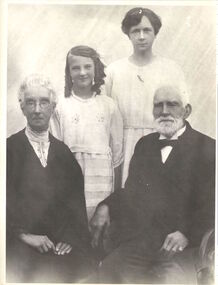
Photograph, Four generations of the Morgan family, circa 1923, c. 1923
James Venn Morgan was one the most important landowners and pioneers in Kew. He founded the Model Dairies. This work forms part of the collection assembled by the historian Dorothy Rogers, that was donated to the Kew Historical Society by her son John Rogers in 2015. The manuscripts, photographs, maps, and documents were sourced by her from both family and local collections or produced as references for her print publications. Many were directly used by Rogers in writing ‘Lovely Old Homes of Kew’ (1961) and 'A History of Kew' (1973), or the numerous articles on local history that she produced for suburban newspapers. Most of the photographs in the collection include detailed annotations in her hand. The Rogers Collection provides a comprehensive insight into the working habits of a historian in the 1960s and 1970s. Together it forms the largest privately-donated collection within the archives of the Kew Historical Society.Mr and Mrs James Venn Morgan of Charles Street, Kew with one of their daughters and their granddaughter.Four generations of Morgan Familyjames venn morgan, kew -
 Kew Historical Society Inc
Photograph, 'Roseneath', Pakington Street, c. 1960
Roseneath is an A-listed house in the City of Boroondara. It was built between 1858 and 1860. This work forms part of the collection assembled by the historian Dorothy Rogers, that was donated to the Kew Historical Society by her son John Rogers in 2015. The manuscripts, photographs, maps, and documents were sourced by her from both family and local collections or produced as references for her print publications. Many were directly used by Rogers in writing ‘Lovely Old Homes of Kew’ (1961) and 'A History of Kew' (1973), or the numerous articles on local history that she produced for suburban newspapers. Most of the photographs in the collection include detailed annotations in her hand.The Rogers Collection provides a comprehensive insight into the working habits of a historian in the 1960s and 1970s. Together it forms the largest privately-donated collection within the archives of the Kew Historical Society.Facade of Roseneath, Pakington Street, Kew. Roseneath, 37 Pakington St., Kew. Built between 1858-1860. E.J. Dunns home. & dogs all soldroseneath, pakington street, kew, dorothy rogers -
 Kew Historical Society Inc
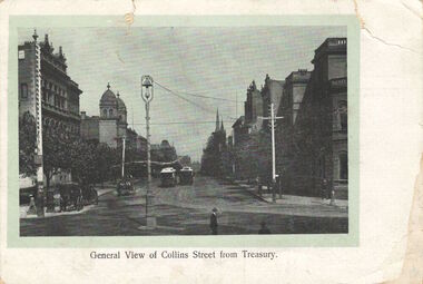
Postcard, General View of Collins Street from Treasury, 1920-1950
This work forms part of the collection assembled by the historian Dorothy Rogers, that was donated to the Kew Historical Society by her son John Rogers in 2015. The manuscripts, photographs, maps, and documents were sourced by her from both family and local collections or produced as references for her print publications. Many were directly used by Rogers in writing ‘Lovely Old Homes of Kew’ (1961) and 'A History of Kew' (1973), or the numerous articles on local history that she produced for suburban newspapers. Most of the photographs in the collection include detailed annotations in her hand. The Rogers Collection provides a comprehensive insight into the working habits of a historian in the 1960s and 1970s. Together it forms the largest privately-donated collection within the archives of the Kew Historical Society.Collins Street, Melbourne looking west.collins street, melbourne, dorothy rogers, postcards - melbourne -
 Kew Historical Society Inc
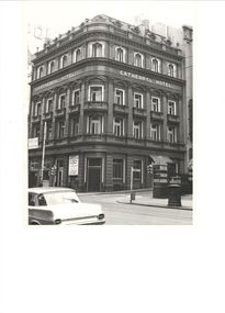
Photograph, Cathedral Hotel, Swanston Street, circa 1965, c.1965
The Cathedral Hotel was demolished by the Melbourne City Council to make way for the new City Square. This work forms part of the collection assembled by the historian Dorothy Rogers, that was donated to the Kew Historical Society by her son John Rogers in 2015. The manuscripts, photographs, maps, and documents were sourced by her from both family and local collections or produced as references for her print publications. Many were directly used by Rogers in writing ‘Lovely Old Homes of Kew’ (1961) and 'A History of Kew' (1973), or the numerous articles on local history that she produced for suburban newspapers. Most of the photographs in the collection include detailed annotations in her hand.The Rogers Collection provides a comprehensive insight into the working habits of a historian in the 1960s and 1970s. Together it forms the largest privately-donated collection within the archives of the Kew Historical Society.Corner view of the Cathedral Hotel on the corner of Flinders Lane and Swanston Street. It was demolished in 1968.cathedral hotel (melb), dorothy rogers -
 Kew Historical Society Inc
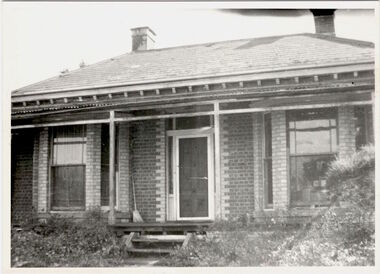
Photograph, 'Gladstone's house', Gladstone Street, Kew, c 1960
This work forms part of the collection assembled by the historian Dorothy Rogers, that was donated to the Kew Historical Society by her son John Rogers in 2015. The manuscripts, photographs, maps, and documents were sourced by her from both family and local collections or produced as references for her print publications. Many were directly used by Rogers in writing ‘Lovely Old Homes of Kew’ (1961) and 'A History of Kew' (1973), or the numerous articles on local history that she produced for suburban newspapers. Most of the photographs in the collection include detailed annotations in her hand.The Rogers Collection provides a comprehensive insight into the working habits of a historian in the 1960s and 1970s. Together it forms the largest privately-donated collection within the archives of the Kew Historical Society.Double-fronted polychrome brick villa in Gladstone Street, Kew. The Historian Dorothy Rogers identified this as Gladstone's house on the back of the photograph. The street had in fact been named after the Prime Minster of England so the naming of the house requires investigation.Gladstone's Housegladstone street, kew, dorothy rogers -
 Kew Historical Society Inc
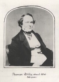
Photograph - Photograph [copy], Thomas Wills about 1856, 56 years, 1856
Wills Street in the Kew ward of Studley Park was named after Thomas Wills. This work forms part of the collection assembled by the historian Dorothy Rogers, that was donated to the Kew Historical Society by her son John Rogers in 2015. The manuscripts, photographs, maps, and documents were sourced by her from both family and local collections or produced as references for her print publications. Many were directly used by Rogers in writing ‘Lovely Old Homes of Kew’ (1961) and 'A History of Kew' (1973), or the numerous articles on local history that she produced for suburban newspapers. Most of the photographs in the collection include detailed annotations in her hand.The Rogers Collection provides a comprehensive insight into the working habits of a historian in the 1960s and 1970s. Together it forms the largest privately-donated collection within the archives of the Kew Historical SocietyA copy of a portrait of Thomas Wills, aged 56 years. Wills was an early landowner in Kew.Thomas Wills - Born Sydney 1799. Built Willsmere Farm ca. 1850thomas wills, kew, dorothy rogers, wills street, wills family -
 Kew Historical Society Inc
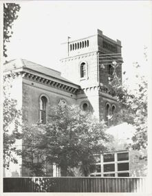
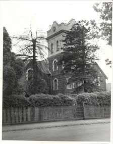
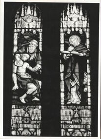
Photograph, 'Good Samaritan Window', Holy Trinity Church, Kew, circa 1960, c.1960
Holy Trinity Anglican Church has been a prominent part of the Kew Community since 1863. This work forms part of the collection assembled by the historian Dorothy Rogers, that was donated to the Kew Historical Society by her son John Rogers in 2015. The manuscripts, photographs, maps, and documents were sourced by her from both family and local collections or produced as references for her print publications. Many were directly used by Rogers in writing ‘Lovely Old Homes of Kew’ (1961) and 'A History of Kew' (1973), or the numerous articles on local history that she produced for suburban newspapers. Most of the photographs in the collection include detailed annotations in her hand.The Rogers Collection provides a comprehensive insight into the working habits of a historian in the 1960s and 1970s. Together it forms the largest privately-donated collection within the archives of the Kew Historical Society.A monochrome photograph of the Good Samaritan leadlight window in Holy Trinity Church, High Street, Kew.:"The memorial brass and the stained-glass window erected in Holy Trinity Church, Kew, in memory of the late Dr. W. Butler Walsh, by some of his former patients, his professional brethren, and other friends, were unveiled on Sunday morning by Dr. Vance, Anglican Dean of Melbourne. The window consists of two lights, with the Good Samaritan as the subject of the left hand light, and St. Luke of the right-hand light. Above the two subjects is the figure of an angel, carrying a scroll, inscribed with the words, "A just man, and one that feared God, and of good report." (The Australasian, 18 June 1904)Good Samaritan window, Holy Trinity Church. Given by parents and friends of Dr. Butler Walsh. Wilton.holy trinity church, kew, dr butler walsh, dorothy rogers, stained glass window, w.b. walsh -
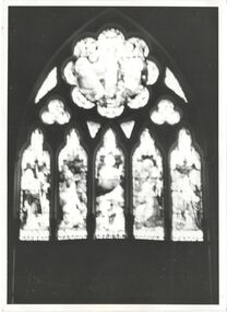 Kew Historical Society Inc
Photograph, Rose Window, Holy Trinity Church (Kew), circa 1960, c.1960
This work forms part of the collection assembled by the historian Dorothy Rogers, that was donated to the Kew Historical Society by her son John Rogers in 2015. The manuscripts, photographs, maps, and documents were sourced by her from both family and local collections or produced as references for her print publications. Many were directly used by Rogers in writing ‘Lovely Old Homes of Kew’ (1961) and 'A History of Kew' (1973), or the numerous articles on local history that she produced for suburban newspapers. Most of the photographs in the collection include detailed annotations in her hand.The Rogers Collection provides a comprehensive insight into the working habits of a historian in the 1960s and 1970s. Together it forms the largest privately-donated collection within the archives of the Kew Historical SocietyStained glass leadlight in Holy Trinity Church, High Street, KewDorothy Rogers: "Rose Window, Chancel, Holy Trinity, Kew"holy trinity church, kew, high street, kew, dorothy rogers, stained glass