Showing 476 items
matching tree bridge
-
 Marysville & District Historical Society
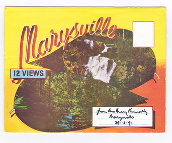
Postcard (item) - Colour photographs, Murray Views, Marysville 12 Views, 1950's
... ) black spur (image 9) nicholl's lookout (image 10) tree ferns ...A fold out postcard of 12 colour photographs of scenes and landscapes in and around Marysville in Victoria.A fold out postcard 12 colour photographs of scenes and landscapes in and around Marysville in Victoria. These photographs were produced by Murray Views in Gympie, Queensland as a souvenir of Marysville.Marysville/ 12 VIEWS from Mrs Mary Keneally/ Marysville/ 28.11.91 PRODUCED BY MURRAY VIEWS./ GYMPIE./ Q COPYRIGHT SAMUEL LEE & CO., PRINTERS. STEAVENSON'S FALLS, MARYSVILLE, VIC. TOURISTS AT MARYSVILLE, VIC. "FRUIT SALAD FARM", MARYSVILLE MAIN STREET, MARYSVILLE, VIC. ROAD SCENE, MARYSVILLE, VIC. THE CROSSWAYS, MARYSVILLE, VIC ROAD TO CUMBERLAND VALLEY, MARYSVILLE PANORAMA FROM BLACK SPUR, MARYSVILLE ROAD, MARYSVILLE, VIC. NICHOLL'S LOOKOUT, MARYSVILLE, VIC. TREE FERNS, MARYSVILLE, VIC. THE BRIDGE, MARYSVILLE, VIC.steavenson falls (image 1), tourists in marysville (image 2), taggerty river (image 3), fruit salad farm (image 4), main street marysville (image 5), road scene marysville (image 6), the crossways (image 7), cumberland valley (image 8), black spur (image 9), nicholl's lookout (image 10), tree ferns (image 11), bridge (image 12), marysville, victoria, postcard, souvenir, murray views -
 Marysville & District Historical Society
Ephemera (Item) - Information brochure, Artworkz Tourism, MARYSVILLE-MARYSVILLE ATTRACTIONS, 23-11-2014
An information brochure on various attractions to be visited in an around Marysville. This brochure was produced by Artworkz Tourism in November 2014.An information brochure on various attractions to be visited in an around Marysville.Disclaimer: The authors have taken care to ensure this/ publication is correct, though please be aware that/ errors and omissions do occur.marysville, victoria, australia, information brochure, bruno's sculpture garden, steavenson falls, gallipoli lake, keppel falls, cora lynn falls, phantom falls, taggerty river visitor area, the beeches, meeting of the waters, cambarville day visitor area, the big tree, the big culvert, keppels hut, keppel lookout, mount gordon, marysville golf course, trestle bridge, marysville caravan park, marysville swimming pool, jock's lookout, yellow dog day visitor area, artworkz tourism -
Marysville & District Historical Society
Book (Item) - Ebook, Artworkz Tourism, Marysville Gallery, 05-2012
An ebook on various attractions to be visited in and around Marysville. This ebook was published by Artworkz Tourism in May 2012.An ebook on various attractions to be visited in and around Marysville.cambarville, cambarville waterfalls, cathedral state park, cora lynn falls, historic trestle bridge, jock's lookout, lady talbot drive, keppel falls, keppel hut, keppel lookout, gallipoli park, phantom falls, steavenson falls, taggerty river, taggerty cascades, the beeches rainforest walk, the big culvert, the big tree, meeting of the waters marysville, meeting of the waters buxton, marysville, victoria, australia, ebook -
 Marysville & District Historical Society
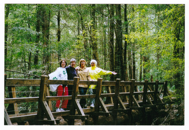
Photograph (item) - Colour photograph, 15-11-03
A colour photograph of a bridge that leads to Big Tree near Cambarville in Victoria.A colour photograph of a bridge that leads to Big Tree near Cambarville in Victoria. It was, at one stage, known to be the tallest hardwood tree in the world standing at 92 meters (301ft, 6 inches). However, it was reduced to 84 meters by a wind storm in 1959. It is a mountain ash. There is a walking track through the forest to the Big Tree.A weekend at Marysville 15-11-03 Catherine Pat Natasha & Normabig tree, mountain ash, cambarville, victoria, photograph -
 Marysville & District Historical Society
Photograph (Item) - Black and white photograph, Bridge Over The Cumberland, c1900
An early black and white photograph of a bridge over the Cumberland Creek near Marysville in Victoria.An early black and white photograph of a bridge over the Cumberland Creek near Marysville in Victoria. The Cumberland Creek is in the Cumberland Valley near Cambarville which was a timber town near Marysville. Cambarville is notable for its giant mountain ash (Eucalyptus regnans) trees within the Cumberland Memorial Scenic Reserve, and relics from former sawmills and gold mining. The Big Culvert is located nearby on the Marysville - Woods Point Road, which was historically part of the Yarra Track. Cambarville was established as a timber mill town in the 1940s. Timber mill owners A Cameron and FJ Barton named Cambarville. They established the mill to salvage timber from trees destroyed in the 1939 bushfires. Cambarville was impacted by the 2009 Black Saturday bushfires and any remaining structures were destroyed.ARMSTRONG COLLECTION 42 STATION STREET/ SANDRINGHAM 3191/ TEL. (03) 9521 5442/ IAN M.L. ARMSTRONG OAMcumberland creek, marysville, victoria, cumberland valley, cambarville, mountain ash, eucalyptus regnans, cumberland memorial reserve, the big culvert, marysville-wood's point road, yarra track, a cameron, fj barton, 2009 black saturday bushfires -
 Eltham District Historical Society Inc
Negative - Photograph, J. P. Lind, Hurst's Bridge, 1885
... behind the bridge on a tree lined hill. The area of Hurstbridge... behind the bridge on a tree lined hill. The area of Hurstbridge ...Looking northwest onto the first bridge at Hurstbridge, 1885. Timber bridge amid rural setting. Two horses graze in an open paddock in the foreground. A house is situated on a rise behind the bridge on a tree lined hill. The area of Hurstbridge was originally known as Hurst’s-bridge after the timber bridge built over the Diamond Creek near Hurst’s station in late 1881/early 1882 on the Hurstbridge-Arthurs Creek Road, Hurstbridge. It was built by John McDonald, of Arthur's Creek and was demolished and replaced in 1917 by a reinforced concrete arch bridge designed by John Monash. Cross Reference Photo No.(s): 1012/1013This photo forms part of a collection of photographs gathered by the Shire of Eltham for their centenary project book, "Pioneers and Painters: 100 years of the Shire of Eltham" by Alan Marshall (1971). The collection of over 500 images is held in partnership between Eltham District Historical Society and Yarra Plenty Regional Library (Eltham Library) and is now formally known as 'The Shire of Eltham Pioneers Photograph Collection.' It is significant in being the first community sourced collection representing the places and people of the Shire's first one hundred years.Digital image 4 x 5 inch B&W Negshire of eltham pioneers photograph collection, hurstbridge, bridge, diamond creek (river), diamond creek (creek), hurst's bridge -
 Eltham District Historical Society Inc
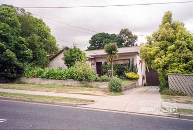
Photograph, Margaret Ball, 58 Bible Street, Eltham, Nov-Dec 1999, 1999
Southeast corner of Bible and Bridge Streets. Owner 1930s-1950s: George and Grace MillerThe Margaret Ball (Pre 1960s Houses) Collection was a personal project initiated to mark the year 2000 and arose as a result of the disappearance of many pre-1960s parts of Eltham due to development. Approximately 200 pre-1960s style houses that were left in Eltham between Main Road and east to Bible Street, between Cecil Street to the north and south to Dalton Street were photographed in late 1999. Not all of the houses could be photographed; some because the garden or trees blocked the view of the house, others because of rubbish or cars were in the way, some because people were working on the house or in the gardens at the time.Roll of 35mm colour negative film, 7 stripsKodak GC 400-6eltham, houses, streets, margaret ball (pre 1960s houses) collection, bible street -
 Eltham District Historical Society Inc
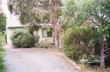
Photograph, Margaret Ball, 104 Bridge Street, Eltham, Nov-Dec 1999, 1999
The Margaret Ball (Pre 1960s Houses) Collection was a personal project initiated to mark the year 2000 and arose as a result of the disappearance of many pre-1960s parts of Eltham due to development. Approximately 200 pre-1960s style houses that were left in Eltham between Main Road and east to Bible Street, between Cecil Street to the north and south to Dalton Street were photographed in late 1999. Not all of the houses could be photographed; some because the garden or trees blocked the view of the house, others because of rubbish or cars were in the way, some because people were working on the house or in the gardens at the time.Roll of 35mm colour negative film, 7 stripsKodak GC 400-6eltham, houses, streets, margaret ball (pre 1960s houses) collection, bridge street -
 Eltham District Historical Society Inc
Photograph, Margaret Ball, 105 Bridge Street, Eltham, Nov-Dec 1999, 1999
The Margaret Ball (Pre 1960s Houses) Collection was a personal project initiated to mark the year 2000 and arose as a result of the disappearance of many pre-1960s parts of Eltham due to development. Approximately 200 pre-1960s style houses that were left in Eltham between Main Road and east to Bible Street, between Cecil Street to the north and south to Dalton Street were photographed in late 1999. Not all of the houses could be photographed; some because the garden or trees blocked the view of the house, others because of rubbish or cars were in the way, some because people were working on the house or in the gardens at the time.Roll of 35mm colour negative film, 7 stripsKodak GC 400-6eltham, houses, streets, margaret ball (pre 1960s houses) collection, bridge street -
 Eltham District Historical Society Inc
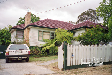
Photograph, Margaret Ball, 92 Bridge Street, Eltham, Nov-Dec 1999, 1999
The Margaret Ball (Pre 1960s Houses) Collection was a personal project initiated to mark the year 2000 and arose as a result of the disappearance of many pre-1960s parts of Eltham due to development. Approximately 200 pre-1960s style houses that were left in Eltham between Main Road and east to Bible Street, between Cecil Street to the north and south to Dalton Street were photographed in late 1999. Not all of the houses could be photographed; some because the garden or trees blocked the view of the house, others because of rubbish or cars were in the way, some because people were working on the house or in the gardens at the time.Roll of 35mm colour negative film, 7 stripsKodak GC 400-6eltham, houses, streets, margaret ball (pre 1960s houses) collection, bridge street -
 Eltham District Historical Society Inc
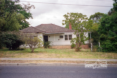
Photograph, Margaret Ball, 95 Bridge Street, Eltham, Nov-Dec 1999, 1999
The Margaret Ball (Pre 1960s Houses) Collection was a personal project initiated to mark the year 2000 and arose as a result of the disappearance of many pre-1960s parts of Eltham due to development. Approximately 200 pre-1960s style houses that were left in Eltham between Main Road and east to Bible Street, between Cecil Street to the north and south to Dalton Street were photographed in late 1999. Not all of the houses could be photographed; some because the garden or trees blocked the view of the house, others because of rubbish or cars were in the way, some because people were working on the house or in the gardens at the time.Roll of 35mm colour negative film, 7 stripsKodak GC 400-6eltham, houses, streets, margaret ball (pre 1960s houses) collection, bridge street -
 Eltham District Historical Society Inc
Photograph, Margaret Ball, 86 Bridge Street, Eltham, Nov-Dec 1999, 1999
The Margaret Ball (Pre 1960s Houses) Collection was a personal project initiated to mark the year 2000 and arose as a result of the disappearance of many pre-1960s parts of Eltham due to development. Approximately 200 pre-1960s style houses that were left in Eltham between Main Road and east to Bible Street, between Cecil Street to the north and south to Dalton Street were photographed in late 1999. Not all of the houses could be photographed; some because the garden or trees blocked the view of the house, others because of rubbish or cars were in the way, some because people were working on the house or in the gardens at the time.Roll of 35mm colour negative film, 7 stripsKodak GC 400-6eltham, houses, streets, margaret ball (pre 1960s houses) collection, bridge street -
 Eltham District Historical Society Inc
Photograph, Margaret Ball, 82 Bridge Street, Eltham, Nov-Dec 1999, 1999
The Margaret Ball (Pre 1960s Houses) Collection was a personal project initiated to mark the year 2000 and arose as a result of the disappearance of many pre-1960s parts of Eltham due to development. Approximately 200 pre-1960s style houses that were left in Eltham between Main Road and east to Bible Street, between Cecil Street to the north and south to Dalton Street were photographed in late 1999. Not all of the houses could be photographed; some because the garden or trees blocked the view of the house, others because of rubbish or cars were in the way, some because people were working on the house or in the gardens at the time.Roll of 35mm colour negative film, 7 stripsKodak GC 400-6eltham, houses, streets, margaret ball (pre 1960s houses) collection, bridge street -
 Eltham District Historical Society Inc
Photograph, Margaret Ball, 80 Bridge Street, Eltham, Nov-Dec 1999, 1999
The Margaret Ball (Pre 1960s Houses) Collection was a personal project initiated to mark the year 2000 and arose as a result of the disappearance of many pre-1960s parts of Eltham due to development. Approximately 200 pre-1960s style houses that were left in Eltham between Main Road and east to Bible Street, between Cecil Street to the north and south to Dalton Street were photographed in late 1999. Not all of the houses could be photographed; some because the garden or trees blocked the view of the house, others because of rubbish or cars were in the way, some because people were working on the house or in the gardens at the time.Roll of 35mm colour negative film, 7 stripsKodak GC 400-6eltham, houses, streets, margaret ball (pre 1960s houses) collection, bridge street -
 Eltham District Historical Society Inc
Photograph, Margaret Ball, 81 Bridge Street, Eltham, Nov-Dec 1999, 1999
The Margaret Ball (Pre 1960s Houses) Collection was a personal project initiated to mark the year 2000 and arose as a result of the disappearance of many pre-1960s parts of Eltham due to development. Approximately 200 pre-1960s style houses that were left in Eltham between Main Road and east to Bible Street, between Cecil Street to the north and south to Dalton Street were photographed in late 1999. Not all of the houses could be photographed; some because the garden or trees blocked the view of the house, others because of rubbish or cars were in the way, some because people were working on the house or in the gardens at the time.Roll of 35mm colour negative film, 7 stripsKodak GC 400-6eltham, houses, streets, margaret ball (pre 1960s houses) collection, bridge street -
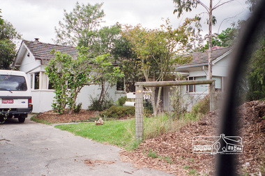
 Eltham District Historical Society Inc
Photograph, Margaret Ball, 74 Bridge Street, Eltham, Nov-Dec 1999 now part of units 72-74 Bridge Street, 1999
The Margaret Ball (Pre 1960s Houses) Collection was a personal project initiated to mark the year 2000 and arose as a result of the disappearance of many pre-1960s parts of Eltham due to development. Approximately 200 pre-1960s style houses that were left in Eltham between Main Road and east to Bible Street, between Cecil Street to the north and south to Dalton Street were photographed in late 1999. Not all of the houses could be photographed; some because the garden or trees blocked the view of the house, others because of rubbish or cars were in the way, some because people were working on the house or in the gardens at the time.Roll of 35mm colour negative film, 7 stripsKodak GC 400-6eltham, houses, streets, margaret ball (pre 1960s houses) collection, bridge street -
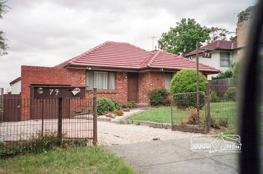 Eltham District Historical Society Inc
Photograph, Margaret Ball, 79 Bridge Street, Eltham, Nov-Dec 1999, 1999
The Margaret Ball (Pre 1960s Houses) Collection was a personal project initiated to mark the year 2000 and arose as a result of the disappearance of many pre-1960s parts of Eltham due to development. Approximately 200 pre-1960s style houses that were left in Eltham between Main Road and east to Bible Street, between Cecil Street to the north and south to Dalton Street were photographed in late 1999. Not all of the houses could be photographed; some because the garden or trees blocked the view of the house, others because of rubbish or cars were in the way, some because people were working on the house or in the gardens at the time.Roll of 35mm colour negative film, 7 stripsKodak GC 400-6eltham, houses, streets, margaret ball (pre 1960s houses) collection, bridge street -
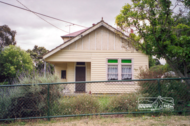
 Eltham District Historical Society Inc
Photograph, Margaret Ball, 77 Bridge Street, Eltham, Nov-Dec 1999, 1999
The Margaret Ball (Pre 1960s Houses) Collection was a personal project initiated to mark the year 2000 and arose as a result of the disappearance of many pre-1960s parts of Eltham due to development. Approximately 200 pre-1960s style houses that were left in Eltham between Main Road and east to Bible Street, between Cecil Street to the north and south to Dalton Street were photographed in late 1999. Not all of the houses could be photographed; some because the garden or trees blocked the view of the house, others because of rubbish or cars were in the way, some because people were working on the house or in the gardens at the time.Roll of 35mm colour negative film, 7 stripsKodak GC 400-6eltham, houses, streets, margaret ball (pre 1960s houses) collection, bridge street -
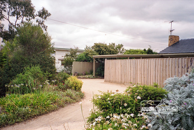
 Eltham District Historical Society Inc
Photograph, Margaret Ball, 75 Bridge Street, Eltham, Nov-Dec 1999, 1999
The Margaret Ball (Pre 1960s Houses) Collection was a personal project initiated to mark the year 2000 and arose as a result of the disappearance of many pre-1960s parts of Eltham due to development. Approximately 200 pre-1960s style houses that were left in Eltham between Main Road and east to Bible Street, between Cecil Street to the north and south to Dalton Street were photographed in late 1999. Not all of the houses could be photographed; some because the garden or trees blocked the view of the house, others because of rubbish or cars were in the way, some because people were working on the house or in the gardens at the time.Roll of 35mm colour negative film, 7 stripsKodak GC 400-6eltham, houses, streets, margaret ball (pre 1960s houses) collection, bridge street -
 Eltham District Historical Society Inc
Photograph, Margaret Ball, 73 Bridge Street, Eltham, Nov-Dec 1999, 1999
The Margaret Ball (Pre 1960s Houses) Collection was a personal project initiated to mark the year 2000 and arose as a result of the disappearance of many pre-1960s parts of Eltham due to development. Approximately 200 pre-1960s style houses that were left in Eltham between Main Road and east to Bible Street, between Cecil Street to the north and south to Dalton Street were photographed in late 1999. Not all of the houses could be photographed; some because the garden or trees blocked the view of the house, others because of rubbish or cars were in the way, some because people were working on the house or in the gardens at the time.Roll of 35mm colour negative film, 7 stripsKodak GC 400-6eltham, houses, streets, margaret ball (pre 1960s houses) collection, bridge street -
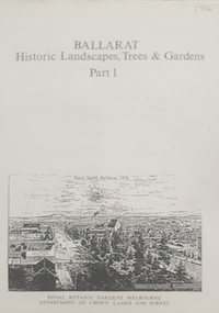 Federation University Historical Collection
Book, Peter Lumley et al, Ballarat: Historic Landscapes, Trees & Gardens, 1983, 1983
Lisa Green and Lisa Morcom of Ballarat College of Advanced Educatiion contributed to this report.275 page landscape study of Ballarat including Trees in the Victorian Landscape; Plant sources early Ballarat nurseries, Botanical Gardens, Lake Wendouree, Fairy Gardens, Victoria Park, Ballaarat Old Cemetery, Eastern Oval, City Oval, Ballarat East Town Hall Gardens, Eureka Stockade, Observatory, Yarrowee, Black Hill, Sovereign Hill, Cheek Channels, Canadian Creek, Poverty Point Reserve, Goldmining Relics, Woah Hawp, Buninyong, street plantings, Russell, Victoria, Bridge Mall, Sturt Street Gardens, Avenue of Honour, Webster, Elms, ballarat, trees, nursery, r.u. nicholls, francis moss, ballarat botanical gardens, victoria park, lake wendouree, ballaarat old cemetery, eastern oval, ballarat east town hall gardens, ballarat school of mines botanical gardens, eureka stckade recreation reserve, ballarat observatory, yarrowee creek, black hill reserve, sovereign hill, ballarat avenue of honour, victoria street plantings, bridge mall plantings, george longley -
 Federation University Historical Collection
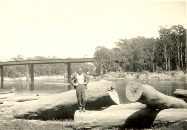
Photograph - Black and White, Frank Wright standing on felled trees, 1940s?
... music in Australia. frank wright felled trees forest bridge ...Frank Wright was a renown resident of Smeaton, where he was born on 2 August 1901. He lived at Laura Villa, and attended Smeaton State School. His father William was a gold miner and his mother's name was Sarah. Their family won many singing and instrumental awards. Frank was tutored by Percy Code and was awarded a gold medal for the highest marks in the ALCM examinations in the British Colonies at the age of seventeen years. He became the Australian Open Cornet Champion by the age of eighteen. A year later, Frank conducted the City of Ballarat Band, and later the Ballarat Soldiers’ Memorial Band. He formed the Frank Wright Frisco Band and Frank Wright and his Coliseum Orchestra. These bands won many South Street awards, and Frank as conductor won many awards in the Australian Band Championship contest. In 1933 Frank Wright sailed to England to conduct the famous St Hilda’s Band and was later appointed Musical Director of the London County Council, where he organized many amazing concerts in parks, in and around the London district. He was made Professor of Brass and Military Band Scoring and conducted at the Guildhall of Music and Drama. Frank was often invited to adjudicate Brass Band Championships around Europe, in Australia, including South Street and in New Zealand. The Frank Wright Medal at the Royal South Street competition is awarded to an individual recognized as making an outstanding contribution to brass music in Australia.Black and white photograph of a man dressed in a suit standing on the trunk of a large felled tree. Around him are other fallen tree trunks, all located on the banks of a river. In the background is a bridge spanning the river and on either side of the water are the tall trees of a forest. The man is Frank Wright.frank wright, felled trees, forest, bridge -
Federation University Historical Collection
Book, Historic Sites Survey: North Central Study Area, 1979, 1979
The North Central Study Area included the Shires of Avoca, Bet Bet, east Loddon, Goulburn, Untly, Kara Kara, Korong, Maldon, Marong, Metcalfe, McIvor, Newstead, Strathfieldsaye, Stawell, Talbot, Clunes, Tullaroop and Waranga. 153 page book with white plastic binding. It is an historic sites survey for the North Central Study Area commissioned by the Land Conservation Council, the Ministry for COnservation and the Australian Heritage Commission. castlemaine, mount alexander goldfield, maldon, percydale, warrenmang, moliagul, tarnagulla, stuart mill, the whipstick, whroo, rushworth, graytown ironbark forest, st arnoaud, new bendigo, landsborough, inglewood, kurting, wedderburn, wehla, kooroora, langham flat, mcintyre, rheola, diamond hill, fosterville, coliban water works, green gully, newstead, muckleford forest, costerfield, graytown, bailieston, waranga irrigaiton system, eucalyptus distillery, mia mia bridge, korokubeal township researce, concegella slate quarry, chewton, fryerstown, kingower, timor, talbot, majorca, carisbroook, clunes, st arnaud, taradale, icomos, dunolly, limestone, castlemaine slate quarry, harcourt granite, taradale railway viaduct, loddon united waterworks trust, gouldburn weir, carisbrook lock-up, history of tree planting in streets, history of public reserves, r.u. nicholls nurseryman, thomas lang, francis moss, ballarat botanical gardens, ballarat school of mines botanical gardens, lake wendouree, victoria park, ballarat, muont holled smith, ballaarat old cemetery planting, eastern oval, ballarat east botanical gardens, ballarat east town hall gardens, eureka stockade reserve, ballarat observatory plantings, yarrowee creek plantings, yarrowee bluestone channels, ballarat woollen mill, band and albion mullock heap, black hill plantings, yarrowee creek channels, canadian creek channel, specimen vale channel, poverty point reserve, union jack reserve buninyong, imperial mine, buninyong, victoria street plantings, bridge mall, sturt street gardens, ballarat avenue of honour plantings, white flat oval plantings, camp street, elms, burnt creek -
 Federation University Historical Collection
Book - Scrap Book, Ballarat School of Mines Scrap Book, 1924 - 1929, c1931
The Ballarat School of Mines was a predecessor institution of Federatin University Australia. The scrap books were kept by the librarians and related to topics of interest to the Ballarat School of Mines, its students and its staff. 17 December 1954 - Ballarat Junior Technical School Headmaster's Report 05 February 1925 - Ballarat School of Mines Museum closure 25 February 1925 - War Trophies Museum 06 May 1925 - Ballarat's Museum. Where is it? Some Interesting Facts 14 May 1925 - White Flat Reserve 21 June 1928 - Ballarat School of Mines Procession 14 March 1929 - Mr A.D.R. Galloway - An Australian Abroad - Tragic end. 1929 - Technical Education 17 October 1929 - Agricultural Engineering 15 February 1930 - Ballarat School of Mines Student Association 20 February 1930 - 61s Annual Meeting of the Ballarat School of Mines 02 June 1930 - R. Young in Belgium and visits battlefields including Hill 60. 19 February 1931 - School Hostel Suggested 14 April 1931 - Frank Pinkerton Obituary 15 October 1921 - Life at Mt Isa (E. Loveland) 18 February 1932 - Discussion on Teachers College (Ballarat Teachers' College) 11 July 1931 - Phoenix Model Locomotive donation to the Ballarat School of Mines 06 May 1932 - The Mt Isa Country 11 Oct 1932 - Death of F.W. Alsopp (former SMB student) 21 January 1933 - Education In Victoria: Will a New Era Open 28 September 1933 - New Teaching System Explained by the Minister 17 February 1934 - Trip to New Guinea (A.F. Heseltine) 19 April 1934 - Early Ballarat - Address by Nathan Spielvogel 30 August 1934 - Ballarat Junior Technical School Tennis Court 23 August 1934 - Welding plant and Battery 17 June 1935 - Men about Town - A.F. Heseltine 21 June 1935 - Vocational Guidance 16 July 1935 - Ballarat School of Mines (history) 03 August 1935 - Men About Town - William H. Middleton 10 August 1935 - A.E.C. Kerrballarat school of mines, martha pinkerton, scrap book, a.w. nicholson, john lynch (junior), mount lyell, leslie evans, leslie blake evans, herald shield for athletics, ballarat school of mines museum, motor mechanics' classes for ladies, farm engineering, villers bretonneux carvings, trengrove, museum, port pirrie, j.i. simpson, reuben s. russelll, ballarat technical art school, charles harvey, elliott gower, la gerche, c. curnow, applied art, macroberston scholarship, ballarat school of mines procession, rag, vale park tree planting, smb ball, pottery classes, delineascope, mica smith scholarship, james peart, burma mnies, smb excursion to western australia, kalgoorlie, elsie mckissock, war trophies, warwick smith, spencer street bridge, war museum, richard j. young, alfred mica smith obituary, reginald callister, john rowell, sewerage installation, h.h. smith, w.h. middleton, olive scott, dolly whitehead, vale park, ballarat war museum opening, repatriation classes, sewerage at the ballarat school of mines, australian coals, j.p. ellsworth, yallourn, w.g. walker, reunion, norfolk island pine, mica smith memorial, jessice smith, harry fern, t. henderson, bhp, john adam, ols students' association, l.b. curnow, laura crouch, signwriting, excursion, port pirrie excursion, albert potter, pearl fricke, technica school sports, percy trompf, ballarat school of mines battery, albert mclean, a.d.r. galloway, alan douglas richard galloway, r.j. young, alan ludbrook, r. timpe, ballarat ironworkers and polytechnic association, h. jolly, carpentry, harold jolly, millinery classes, phoenix model locomotive, s.j. morgan, r.d. bannister, juvenile industrial exhibition, w.h. shaw, j.c. winds, f.h. davis, h.r. worland, w.t. magee, l. george, l. balhausen, white flat oval, resue from yarrowee creek, e. berriman, ballarat teachers' college, reg mcconnell, mount lyell co, munro reaper, munro reaper model, weaving classes, mervyn trimmings, briquette dust, edna findlay, jean rogers, n. mccallum, jessie glass, classroom ventilation, art metal, charles fenner, levi molyneux, olice scott, poster competition, kerr grant, w.h. steane, h. caddy, colvin smith, claude creelman, robert colins, stan hillman, n.c. heathcote, egg collection, john alexander, nornie gude, charles deane, graham hopwood, roswald john dart, max wilson, new battery, jess hopwood, william middleton, a.e.c. kerr, hand weaving classes, m. martin, a.h. leeson, mona rogerson, lorna bailey, prospectors classes, edwin robinson, kalgoorlie vist, railway locomotive -
 Yarra Glen & District Historical Society
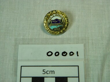
Badges, Stokes, c.1958
The 'Back to Yarra Glen' event was held on the Australia day weekend, 1959. Badge is circular with filigree work around the outer rim. The inner circle has a picture of the Yarra Glen bridge over the light blue river with the dark blue mountains in the background and green river bank in the foreground. There are green trees at each end of the gold bridge. The sky is white. On the green grass foreground is the date 1959. Above the mountains are the words 'Back to Yarra Glen'. The diameter is 2.5 centimetres. It is made of pressed metal, maybe brass, with gold colouring around the outer edge and back. On the front of the badge "Back to Yarra Glen" is across the top and "1959" on the bottom. "Stokes Melb" is on the back -
 Yarra Glen & District Historical Society
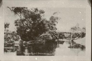
Sepia postcards, Yarra Glen bridge
Photograph of wooden bridge over the Yarra River taken from a point just north of the river crossing at Yarra Glen early 20th century. The town of Yarra Glen is to the right (out of frame). A post and rail fence indicates the road to Yering and Lilydale to the east of the bridge. A bend of the river is in the foreground and trees line the eastern bank.On back of postcard at the top "POST CARD". On the left hand side "THIS SPACE MAY BE USED FOR PRINTED OR WRITTEN MATTER". On the right hand side "ONLY THE ADDRESS TO BE WRITTEN HERE". In a box in the right hand corner "A HALF-PENNY STAMP TO BE PLACED HERE". Along the left hand margin "Ajax series. Printed in England" yarra river, post and rail fence, wooden bridge, river crossing, river bridge, yarra glen bridge, yering -
 Yarra Glen & District Historical Society
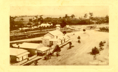
Sepia postcards, Yarra Glen
Sepia postcard with a view taken from the Grand Hotel tower looking down on Bell Street and the railway crossing at Yarra Glen very late 19th century. Young street trees on Bell Street. On east side of Bell Street are a dwelling, a general store, the Victoria Hall, a horse trough. Beyond the railway line is 'River View', the bridge over the river and the Yering flats.On back of postcard at the top "POST CARD". On the left hand side "THIS SPACE MAY BE USED FOR PRINTED OR WRITTEN MATTER”. On the right hand side "ONLY THE ADDRESS TO BE WRITTEN HERE”. In a box in the right hand corner "A HALF-PENNY STAMP TO BE PLACED HERE". Along the left hand margin "Ajax series. Printed in England". In blue biro is written "G. Keets Yarra Glen". Copy 2 has the following handwritten in black ink: "Yarra Glen. 28.8.11. Dear Maggie Hope you will like the Postcard. I also hope your head is better. On Saturday we took the kitten down to Dawborn's shop to catch some mice. When we got down there the kitten got away from us and we never got it till Monday morning. This is all the news this time. From your loving cousin, Walter.yarra glen, railway line, grand hotel, victoria hall, bell street, tree guards, railway crossing, river view, street trees, bell st, general store, horse trough -
 Yarra Glen & District Historical Society
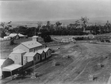
Black and white photographs, Yarra Glen railway crossing c.1900
Black and white photograph in light brown card slip case. The slip case has an image on the front cover of a head and shoulder bust. The photograph was taken about 1900 from the tower of the Grand Hotel looking down upon the Victoria Hall and the railway crossing. In the lower left corner is W.J.Dawborn's General Store. In front of the store is a horse and spring dray and another horse hitched to a veranda post. Next to the store is the Victoria Hall and beyond that a water trough. The railway crossing is in the centre of the picture with two railway cattle trucks next to the cattle yards. Beyond the railway on the left hand side is the property later known as 'River View'. Beyond the river lined with trees are the Yering flats across which can be seen the long trestle railway bridge. In the foreground of the picture is Bell Street lined with trees in wooden tree guards.yarra glen, victoria hall, railway crossing, river view, general store, w j dawborn, horse and cart, horse and dray, spring dray, horse hitched, hitching post, water trough, railway truck, cattle truck, cattle yards, stock yards, yering flats, trestle railway bridge, trestle bridge