Showing 3899 items matching "bricker"
-
 Bendigo Historical Society Inc.
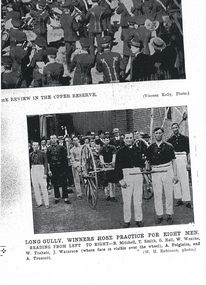
Photograph - LONG GULLY HISTORY GROUP COLLECTION: LONG GULLY WINNERS HOSE PRACTICE FOR EIGHT MEN
Copy of a black and white photo of the Long Gully Winners Hose Practice for Eight Men. The eight men are: B Mitchell, T Smith, G Hall, W Wearne, W Trahair, J Waterson, A Polglaise and A Truscott. Two men are holding the front of the hose cart and the others are standing beside or behind it. There is a crowd in the background. They are all in front of a brick building. This photo is an enlargement of the photo on 11010.207 b.bendigo, history, long gully history group, the long gully history group - long gully - winners hose practice for eight men, b mitchell, t smith, g hall, w wearne, w trahair, j waterson, a polglaise, a truscott, vincent kelly, w h robinson -
 Bendigo Historical Society Inc.
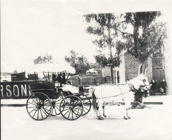
Photograph - HARRY BIGGS COLLECTION: HORSE DRAWN CARRIAGE
Photograph. Harry Biggs Collection. A black & white photo of a man in a suit sitting in a sulky. The top of the sulky has a cover with a fringe around it & the man has a rug over his knees. He is holding the reins of a decorated horse which the sulky is attached it. At the back is a work place & the letters RSONS can be seen. Beside that is a brick building & 2 school children, a boy and girl are standing in front of it.person, individual, casual, harry biggs collection, horse drawn carriage -
 Stawell Historical Society Inc
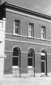
Photograph, Victoria Bank in Main Street Stawell 1991 - 2 Photos
This two story building was once The Victoria Bank, in Main Street Stawell later other businesses. Photo taken in 1991. The building now restored, and the home of Ron & Trudy Smith, who conduct a book exchange.Two black and white photographs of a two story brick building once The Victoria Bank and later a Book exchange. Doorways and windows on the ground floor have similar arch designs. The three top windows are rectangular in shape with a parapet on top of the building. One photo is a closer view of the building than the other. The photos may have been taken at different times as the window curtains appear different.stawell -
 Southern Sherbrooke Historical Society Inc.
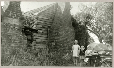
Photograph - Hermon home, Menzies Creek
Black and white photograph of three young children, Joy and Lyn Hermon and a friend, standing beside a timber and corrugated iron house with two brick chimneys, built in Menzies Creek. Joy and Lyn are the great grandchildren of James Hermon who built the house in 1874-1878. In 1885 the house became the Aura/Menzies Creek post office. Copy given to Sherbrooke Centenary Committee in 1989 by Hermon family. -
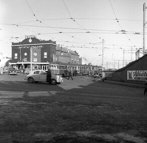 Ballarat Tramway Museum
Negative, Geoff Grant, 3/09/1955 12:00:00 AM
Negative No. N360 and black and white print made by a laser printer (stored in folder ) of a line up of trams in Railway Avenue Caulfield, for race traffic on 3/9/1955. Tram W2 347 is leading. Has the Crystal Palace Theatre in the background and advertisements for Robur Tea and Alsatian Paints and Varnishes on the railway embankment brick walls. hi res scan made and image updated 23/5/2020.trams, tramways, melbourne, caulfield, race traffic, tram w2 347 -
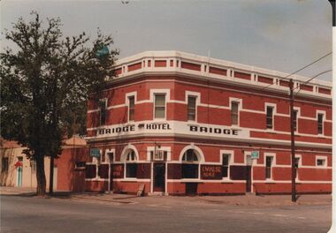 Bendigo Historical Society Inc.
Photograph - BENDIGO HOTEL COLLECTION: BRIDGE HOTEL, BRIDGE STREET, BENDIGO
Colour photograph: Bridge Hotel,Bridge Street, Cnr Cemetery Street, Bendigo. Two storey red brick hotel, no verandah. White trim around windows and across top pediment. Large tree on LH side of image. Formerly called the Hibernia. Sign out front 'Chinese Meals' Hotel situated next door to Bendigo Chinese Association rooms, just visible on LH side of image.bendigo, hotel, bridge hotel -
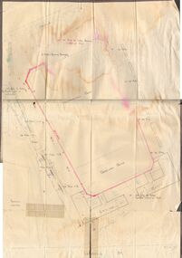 Bendigo Historical Society Inc.
Document - BERT GRAHAM COLLECTION: PLANS FOR BENDIGO EAST, 2/12/1957
Documents, Bert Graham Collection, (a) Plan for Kennedy Street Reconstruction, Lansell Street, Charleston Road. Plan drawn by City of Bendigo, City Engineer on 18 May 1976.(b) Plan for Brick dressing pavilion at Eastern Park, Bendigo, by City of Bendigo Engineer, R. Anderson, date 2/12/1957. ( c ) Plan for Swimming Pool. Parts (a) and (b) have not been scanned because of their size.bendigo, clubs, bendigo east swimming club -
 Bendigo Historical Society Inc.
Book - Nanga Gnulle - A Memoir by Robin Green, 2022
Soft cover book of 124 pages entitled Nanga Gnulle a Memoir. Colour sketch of the house by Stan Thomas on the front cover. An introduction by Mike Butcher on the back cover. The development of Nanga Gnulle, a mud brick home on several acres, is described and illustrated with numerous B&W and colour photos. Published by R.E. and M.L. Green, 9 Golden Glade, Strathdale, 3550 in 2022 Printed in Bendigo by Bart'n'Print. M & J Qualtrough sticker on title page. bendigo architecture, nanga gnulle -
 Kew Historical Society Inc
Photograph - 'Reno', 10 St John's Parade, John T Collins, 1977
‘Reno’, stood on the east side of St John’s Parade. Its earliest recorded owner was the architect Samuel Cocking who lived there from c.1865 until his death in 1888. The original landholding was bordered by Cotham Road, Glenferrie Road, Wellington Street, and Charles Street. The southern portion of this land included a fine orchard, with many imported trees. The old summer house, at first in the orchard, was later removed to the house garden. The MMBW Detail Plan No.1576 (1904) shows the remaining portion of the original land holding, including a semi-circular pathway at the front, and garden features such as an aviary, a fountain and grotto, and a fernery. The garden including rare plants supplied by Baron Von Mueller, surrounds the cottage in a tangled frenzy. Despite a ‘local significance’ classification by the National Trust, the house was demolished in 1977.Partial view, north side of the weatherboard cottage in St John's Parade, Kew, known as 'Reno' (demolished 1977). Architectural elements revealed in this photo by John T Collins include: two wing, hip roof construction; external buildings at angles to main wing; corrugated iron roofing [over shingles]; brick chimney external to building; unvarnished/unpainted external weatherboards. General dilapidated condition. "Kew 'Reno' 10 St Johns Pde / John Collins, 11 Anderson Road, Hawthorn East, 3123, Film 35B Exposure 27"reno - st john's parade -- kew (vic.), john t collins -
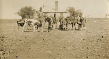 Surrey Hills Historical Society Collection
Photograph, Mair family visiting the Jarmans at Derrinallum, c1927, c1927
David Miller (Dave) Mair (1879-1938) married Lily Vipond Deakin (1890-1945) in 1910. They had 5 children: Geoffrey David (1913-1970), Beryl (1916-1976), Gwynneth (1917-1997), Isabel Lillian (1921-1997) and Shirley Inez (1928-1968). Personal communication from Laurie Newton, Beryl's daughter: Dave and Lily initially lived in East Melbourne after they married. Dave walked across the gardens to work at the MCG. He never drove or owned a car. Geoffrey, Beryl and Gwynneth were born in East Melbourne. They subsequently moved to Louise Avenue, Mont Albert and Isabel may have been born while they were there. Later they purchased 20 Barton Street, Mont Albert. Shirley was born after they moved to Barton Street. Electoral roll details: 1919 1922 24 Louise Avenue, Mont Albert 1924 20 Barton Street, Mont Albert Dave Mair was a very keen sportsman. This is part of a large donation of material from the Deakin, Mair and Young families. The Deakin, Mair and Young families had many connections with Mont Albert and Surrey Hills.A sepia photo of a girl bending towards a calf feeding from a bucket with a man overlooking. There are 6 calves altogether feeding from a small trough and 2 buckets. In the background is an Edwardian timber house with a brick chimney and a corrugated iron roof. There is a centrally positioned (?) rear door with windows either side. There is a tank to the left of the house, which is enclosed within a post and wire fence. The surroundings look very bare.On the rear in black ink: "Feeding time for the / calves at Derrinallum / B Mair / 20 Barton St / Surrey Hills / E10." Writing may be that of Lily Mair. In blue biro: " Beryl Gwen ? Mr Jarman" Thought to be Beryl Mair's handwriting. Photographic process stamp "C 311" "KODAK PRINT" in black. Despite the inscription including Gwen Mair, only one child can be seen. beryl mair, derrinallum, farms, mr jarman -
 Surrey Hills Historical Society Collection
Photograph, Kiora, 16 Albert Crescent, Surrey Hills (demolished)
The house was known as Rothwell and later as Kiora. It was the home of Mr and Mrs Tom Bulmer for many years. It has been demolished.Black and white photo taken from the street of a timber Edwardian home with 2 double brick chimneys and a galvanised iron roof. It has a verandah on 2 sides with wooden fretwork and the pathway leading towards the house has an archway over it. There is a similar archway on the LHS of the photo. The backyard is divided off with lattice fencing and the property has a simple front picket fence with gate behind which is a privet hedge.edwardian style, houses, kiora, rothwell, bulmer family, (mr) tom bulmer, albany crescent, surrey hills -
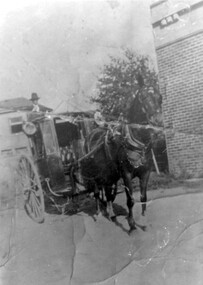 Surrey Hills Historical Society Collection
Photograph, Fred Lyons and his hansom cab
This is one of a series of photos donated by Arthur Lyons. From 1907 a cab service operated from near the railway gates in Union Road. It was established and maintained by Mr C Fraser until c1916. George Rea either took over then or set up in opposition. Fred Lyons initially worked for George until he set up his own business. In time he changed over to a motor vehicle and continued his service until 1960. Frederick Adolphus Lyons (1891-1980) was born in Surrey Hills, son of Thomas and Catherine Lyons. He married Elizabeth Ruby Hall in 1918. They lived just around the corner at 55 Sunbury Crescent. The Lyons’ home in Sunbury Crescent was called ‘Knopshambury’ - this was probably a misspelling of Knockshanbally in Co Kilkenny, the birth place of Fred’s father, Thomas Edmund Josias Lyons (1846-1915). Arthur Lyons was born in Surrey Hills on 12 Jun 1920. He became a motor mechanic / welder and lived at 55 Sunbury Crescent. The donation was made while he was in hospital. He died shortly afterwards (23 Sep 1990). Donation was finalised by a neighbour, Mrs Florence Ann Armitstead, wife of Glen Victor Armitstead. Glen was a local hairdresser. They moved to 11 Sunbury Crescent after their marriage in 1939. Arthur had no relatives to distribute the material to.Black and white photo of Fred Lyons with his hansom cab, taken between 1916-1920. It shows a horse harnessed to the cab, the door of which is open so that the buttoned seat is visible. The cab has large lamps on each side. Mr Lyons, in hat, is standing on the back of the cab. There is a large brick wall of a building to the right of the cab with a mature tree beside it and houses can be seen behind the cab. horse-drawn vehicles, carriages and coaches, fred lyons, george rea, frederick adolphus lyons -
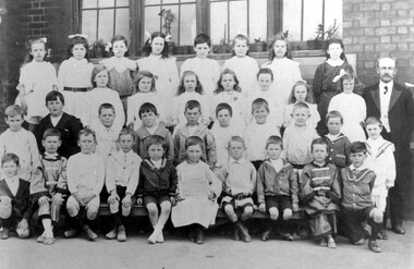 Surrey Hills Historical Society Collection
Photograph, Surrey Hills Primary School class photo, circa 1911, 1911
One of the boys is believed to be John Reaburn; date is approximate.Black and white photo of a class of 34 children at Surrey Hills Primary School taken outside against a brick wall with a central window. It may be a class of mixed age children. There are 20 boys and 14 girls. One boy holds the class identification board (illegible); several are dressed in 'sailor shirts' and a couple in oriental-looking costumes. The children are flanked by a senior male teacher and a junior female teacher.surrey hills primary school, schools, education, primary education, children, john reaburn -
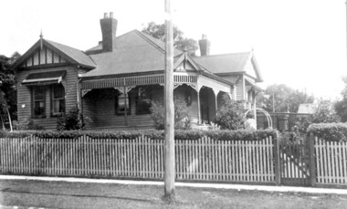
 Bendigo Historical Society Inc.
Photograph - T C WATTS & SON COLLECTION: PATRICK STREET, BENDIGO, 1933
BHS CollectionBlack and white photograph mounted on rectangular brown board. House, rendered, verandah with brick balustrade and barley sugar pillars, tiled roof, 2 chimneys, small panelled windows, double central door, woven crinkled wire fence and gate. Patrick Street. On backof photo: ' Geo De Araugo, Patrick St., £850' Date Stamp 30 May, 1933. 2012 photo of house attached.Frank A. Jeffree, Bendigobendigo, business, t c watts and son -
 Charlton Golden Grains Museum Inc
Photograph, Brownjohn, Reg, Rear of Johnson's Bridge Store c. 2000, c.2000
Derelict rear of building built as Bridge Store in 1872 for Peter Johnson, later Wylie's Building and a furniture store. Photo taken for the Museum by R. Brownjohn.Colour photograph of the rear of an old, brick two storey building. Building appears derelict and disused. Part of the roof is missing on the lower section and the beams are exposed. Verandah is sagging. Gas tank/hot water service in corner in the centre of the photo. Single door to the right of the gas tank and double doors to the left. One large and one small window in the upstairs section. Chimney on LH side of upper storey.bridge store, peter johnson, wylie's building, charlton, business -
 Charlton Golden Grains Museum Inc
Photograph, Globe Hotel c. 1987, c.1987
Globe Hotel, High St Charlton, established 1874 by John Walsh. This is the third building on the site. The first was destroyed by fire and rebuilt. It was then rebuilt as a two-storey hotel in 1940. It closed as a hotel in the early 1970's and became offices and flats. The Charlton Gentlemen's Club on the RH side was established in 1900. Photo is part of a series of streetscapes taken in 1987 for the Charlton Shire. Globe Hotel third (building) established 1874 as single storeyed and Charlton Gentlemen's Club est. 1900. Globe destroyed by fire and rebuilt in 1940. In 1970's to became offices and flats.Colour photograph of two storey red brick building. Signage on the windows reads SOIL CONSERVATION AUTHORITY (not all words fully visible). A man on a cherry picker in front of building trimming a tree. Signage on the side of the white truck says North Central TRAVEL TOWER Hire. Two orange safety cones on the road. RH side is the single storey, glass-fronted building with a white-framed door. charlton, globe hotel, soil conservation authority, business, industry, agriculture -
 Charlton Golden Grains Museum Inc
Photograph, East Charlton Hotel, High St Charlton c. 1987
East Charlton Hotel built in 1875 by John Flug to replace his original log and bark inn built 1863. The first inn was about 100 metres behind this building and it was Charlton's first commercial building. The hotel was rebuilt by C. Klug in 1891. It was rebuilt as a two storey building in 1925. Part of a streetscape series done for the Shire of Charlton in 1987.Colour photograph of Spanish mission style, two storey white building. Arched verandah on lower level. Signage above veranda reads EAST CHARLTON HOTEL. Tree in front of building. and several parked cars. Yellow panel van in lower RH corner. Single storey pale brick building across the drive way on LH side. Red and white sign for SUPERMARKET on RH side.east charlton hotel, john flug, c. klug, charlton, business -
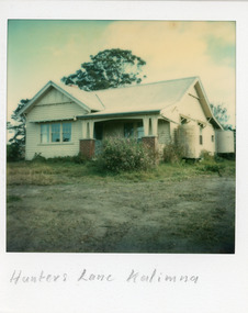 Lakes Entrance Historical Society
Photograph - Housing, 1980
Owners at various times : Bliss family, Dr M E WinfieldColour Polaroid photograph of a small timber dwelling, gable roof across building and front room extension. Timber veranda posts set in brick piers. Sash windows, six panes, in upper, single pane in lower. Galvanised iron tanks at front and rear corners of house. Timber sunshades over windows. View of the North Arm. Situated at Hunters Lane, Kalimna, Lakes Entrance, Victoriahouses, architecture -
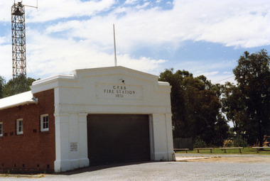 Charlton Golden Grains Museum Inc
Photograph, Charlton Shire, Charlton Fire Station c. 1987, c.1987
The Charlton Fire Station was built in 1931.Colour photograph of the Charlton Fire Station. A single storey red brick building with a white frontage. A large entrance and three high high windows down the side. There is a plaque on the LH side of the main entrance that can't be clearly read.. The signage above the main entrance reads C.F.B.B. FIRE STATION 1931 There is a light above this sign. The fire tower is at the rear of the building. There is a low railing fence on the right side.charlton fire station, charlton fire brigade, public services -
 Bendigo Historical Society Inc.
Document - BEEBE, BAPTIST CHURCH DRAWING
Parchment paper architect drawing by William Beebe. Printed heading, 'Proposed Sunday School, Baptist Church', dated 21/9/ 05. Scale 8 feet to Inch. Eight rooms surrounding 30 feet x 50 feet main hall lighted by clearstory. Handwritten cost estimated if weatherboard £850, brick £1040, fencing not included. Land & house 72-foot frontage. Unknown donorbendigo, churches, baptist, beebe -
 Whitehorse Historical Society Inc.
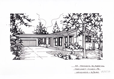
Artwork, other - Ink Line Drawing, Margaret Picken, 165 Mahoneys Rd., Forest Hill, 1994
A property illustration by Margaret Picken Commissioned by the real estate agency Woodards Blackburn for the purpose of advertising 96 Mahoneys Rd., Forest Hill. This property is listed as having sold for $142,500 in 1994. Made by using Rotring ‘Rapidigraph’ drafting pens with Rotring ink on Rapidigraph polyester drafting film, double matte. Trained as a cartographic draftsman within the mining industry, Margaret Picken is an artist who worked producing property illustrations for real estate agencies in eastern suburbs of Victoria from 1983-2005. Retiring from the industry as technological changes favored coloured photography over illustrations, and commissioning companies over sole contractors.This artwork is of Historical Significance as a record of local domestic architecture.A black ink line drawing on drafters film by Margaret Picken, of 165 Mahoneys Rd., Forest Hill, a brick path leading to a flat roofed single story house set back from a lawn and garden in the foreground. There are two hole punch holes centre near the upper edge. There are smudges near the top left corner of the artwork. There are light linear marks on near the centre right border. 165 Mahoneys Rd., Forest Hill Margaret Picken -94 Woodards - B/Burnwhitehorse historical society, schwerkolt cottage, housing, architecture, margaret picken, house, garden, forest hill -
 Melbourne Tram Museum
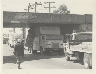
Photograph - Black & White Photograph/s, The Met, 1980's?
Black and White photograph of a butchers truck (K. Potts?) truck having collided with the rail over road bridge, Merri Parade Northcote, possibly c1980. MMTB Photograph - same handwriting as Reg item 288. Has a policeman walking alongside, the damaged truck, other vehicles including a Clifton Bricks truck. The bridge has the low clearance sign in metres, but with a newer imperial sign alongside.In ink on rear "Merri Road Northcote"trams, tramways, northcote, bridges, collision -
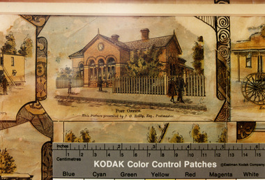 Charlton Golden Grains Museum Inc
Photograph - Lithograph, Rider & Mercer, Views of Charlton
Charlton Post Office, High St, December 1891, built in 1879 to replace the original Post Office built in Camp St in 1878.Copy of Charlton Post Office High Street 1891 taken from the lithographs of Rider & Mercer. Possibly hand coloured. Brick building with three arched doorways and a clock above the central arch. Picket fence. One person standing in front of the building, a man walking past and a couple walking past a gate. Ruler showing in lower part of photo with KODAK Colour Control Patches written on it.Post Office. This picture presented by J. G. Reily, Esq., Postmastercharlton, charlton post office, business, industry, lithograph -
 Glen Eira Historical Society
Album - Album page, Kambrook Road, Circa 1972
This page of photographs is part of the Caulfield Historical Album 1972. This album was created in approximately 1972 as part of a project by the Caulfield Historical Society to assist in identifying buildings worthy of preservation. The album is related to a Survey the Caulfield Historical Society developed in collaboration with the National Trust of Australia (Victoria) and Caulfield City Council to identify historic buildings within the City of Caulfield that warranted the protection of a National Trust Classification. Principal photographer thought to be Trevor Hart, member of Caulfield Historical Society. Most photographs were taken between 1966-1972 with a small number of photographs being older and from unknown sources. All photographs are black and white except where stated, with 386 photographs over 198 pages. First 2 images: milkbar and residence corner Kambrook and Balaclava Roads ie south west corner - building named Airdrie 3rd image: https://vhd.heritagecouncil.vic.gov.au/places/43737 - re 26 Kambrook Road and 345 Balaclava Road corner building ie south east corner: A prominently situated two-storeyed complex of late Victorian buildings consisting of "Wybar's Buildings" occupying the Balaclava Road/ Kambrook Road corner and the "Caulfield Bakery" facing Kambrook Road, separated by a driveway from a single storeyed shop. The main building has a comer splay and balustraded parapet with curved pediments, the words "Wybar's Buildings 1887" having been obliterated but "Caulfield Bakery 1887" with the characteristic wheatsheaf surviving in raised cement work. The walls are stuccoed and richly ornamented with bracketed cornices and keystones with masks extending to the Bakery. The main building is further distinguished by the Masonic symbol of the mason's dividers in the pediment whilst the upper level of the bakery is in overpainted brickwork. The single storeyed shop incorporates the bracketed cornice and consoles characteristic of the main buildings and is in other respects a utilitarian structure. 4th image: https://vhd.heritagecouncil.vic.gov.au/places/42415 (on 24/01/2021) - 196 Kambrook Road An imposing late Victorian poly-chrome brick asymmetrical villa with corner verandah and projecting west facing wing with faceted window bay to the facade. Body bricks are red and relieved by cream and black brick banding and by cream bricks to the bracketed eaves. The fretted barge with king post treatment and timber posted verandah are unique in the Municipality and unusual in the metropolitan area and demonstrate an understated appreciation of the emerging Queen Anne mode.345 Balaclava and 26 Kambrook Roads HO91 - City of Glen Eira https://vhd.heritagecouncil.vic.gov.au/places/43737 (on 24/01/2021) "Wybar's Buildings" at the corner of Balaclava Road and Kambrook Road are important as a prominent late Victorian commercial development incorporating a variety of activities including a bakery and possibly a coffee palace, the latter understood to be unique within the municipality, but characteristic of the period. It is a rare complex of its type in Caulfield and is important also as evocative evidence of the late Victorian Land Boom and the creation of a small now defunct commercial centre at this location by the George Wybrow. 196 Kambrook Road HO122 - City of Glen Eira https://vhd.heritagecouncil.vic.gov.au/places/42415 "Glencoe" is situated at no. 196 Kambrook Road, Caulfield North and was built for the boot manufacturer, Robert Bruce Mair, in 1888. It is of historic and aesthetic significance. It is historically significant (Criterion A) as the home of an inner suburban industrialist, notable a boot manufacturer, demonstrating the attraction of Caulfield as a residential location for the manufacturers of the metropolis during the late Victorian Boom period. It is aesthetically significant (Criterion E) as a very early example of a Queen Anne influenced late Victorian villa, comparing at the State level with ''Woodlands'' (1888), North Essendon, generally acknowledged to be one of Australia's earliest houses to fully exploit this emerging style. The ornamental timberwork is especially expressive of the new architectural fashion and compares with the house at 33 Clarence Street, Elsternwick (1888-89).Page 105 of Photograph Album with two photographs of a milk bar and attached residence, one older photograph of Wybar's Building and another photograph of a house on Kambrook Road (all are landscape).Handwritten: 196 KAMBROOK ROAD / 1970 - GAFFNEY MRS S.M. [under bottom right photo] / 100 [bottom left]trevor hart, kambrook road, victorian style, caulfield north, parapets, wybar's buildings 1887, caulfield bakery 1887, architectural features, painted bricks, balaclava road, george wybrow, shops, milk bars, airdrie, polychrome bricks, verandahs, queen anne architectural style, houses, glencoe, robert mair -
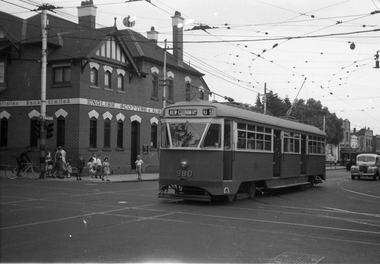 Melbourne Tram Museum
Negative, Wal Jack, 9/02/1951 12:00:00 AM
Black and white negative, by Wal Jack, of PCC 980, northbound bound in Glenferrie Road at High Street with the destination of Kew Cotham Road. The Bank was replaced by a more modern looking building during the 1970's. In the background is the ES&A bank on the corner. Jane Nigro advised 9/9/2020: "1907 Photo of the E. S. & A. Bank on the corner of High Street and Glenferrie Road, Malvern. In 1885 land on corner of Glenferrie Road & High St. (40' x 150') was purchased by E.S. & A. Bank. A condition of sale was that the bank erect on the land a 'substantial brick building to be used as a branch bank', within 24 months. The E.S. & A. Bank, single-storey four roomed brick, was built in 1888. The first manager was Frederick Leonard. In 1907 a second storey, including residential quarters for the manager, was added to bank at a cost of £1400.The Bank was demolished in 1958-9and replaced with present building."trams, tramways, pcc class, glenferrie road, route 69, kew- cotham rd, tram 980 -
 Glen Eira Historical Society
Article - Methodist Church, Grange Road, 183 – 185, Glen Huntly
1/A photocopy of a typed document of notes, source and date unknown, describing a brief history of the former Methodist Church in Grange Road, GlenHuntly. 2/Two colour photographs dated November 1980 of the front and side view of the church, and two undated photographs of the foundation stones, laid 1922 for the church and 1932 for the brick hall. 3/Also a newspaper article by Andrew Molloy dated 25/02/1990 discussing development options for potential buyers, source unknown.glen huntly, smith a. w. f. mr, foundation stones, grange road, molloy andrew, land sales, glen huntly road, methodist church, auctions, wattle ave., uniting church, churches, king f. l mr., presbyterian church of eastern australia, monuments and memorials, temples, religious ceremonies, chinese community, real estate agents, commercial development, residential development, child care, glen huntly post office, official buildings, weatherboard buildings, clergy, church residences, meeting rooms -
Phillip Island and District Historical Society Inc.
Photograph, 1876
Left of photograph Bergin & Co, Griffiths Point Store in very large lettering. Residence above store, four open windows. Woman in white blouse and long black skirt entering one of two doors. The weatherboard building right on street. Next door San Remo Hotel. Bar entry on left. Large window on brick wall. Weatherboard upper storey with verandah and elaborate pillars wrought iron work and big turret attic towards back.Beautiful blown-up picture of the store and hotel side by side. Store open for business. Lady enteringlocal history, photography, photographs, slides, film, griffiths point store, san remo hotel, black & white photograph, miss elms san remo -
 Greensborough Historical Society
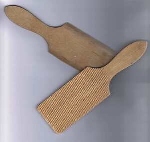
Butter Pats, Unknown, Pair of butter pats, 1920-1930
These wooden butter pats were used to shape butter into bricks; making butter ready for sale and use. The excess moisture would be squeezed out of the butter; which was then transferred to a wooden board. The butter maker would hold one of these pats in each hand and work the butter into shape. These wooden pats are thin; light and easy to hold. The inside face is serrated to grip the butter and squeeze out any further water. It was also used to make patterns on the finished butter. An original pair of butter pats. Given to a Greensborough local in 1975, but used by the previous owner and her mother.Wooden butter pats with handle. One side is ribbed, the other smooth.butter pats, butter making, nancy fowkes -
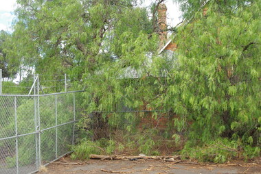 Greensborough Historical Society
Photograph - Digital Image, Bundoora Primary School Bu1915 (old building) 1, 18/03/2014
Bundoora Primary School No.1915 was constructed in 1877 of brick on a bluestone base with an iron roof and small porch. The school consisted of a single room with the dimensions 30 feet by 18 feet. It was a small rural school and in use for over 100 years. Today it sits abandoned at the intersection of Plenty Road and the Metropolitan Ring Road. The School has a Victorian Heritage Overlay (no H062) Photograph by Marilyn Smith 2014. Update: The old building has been incorporated into a childcare facility.Digital copy of colour photograph. bundoora primary school, bundoora state school -
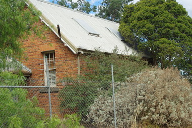 Greensborough Historical Society
Photograph - Digital Image, Bundoora Primary School Bu1915 (old building) 2, 18/03/2014
Bundoora Primary School No.1915 was constructed in 1877 of brick on a bluestone base with an iron roof and small porch. The school consisted of a single room with the dimensions 30 feet by 18 feet. It was a small rural school and in use for over 100 years. Today it sits abandoned at the intersection of Plenty Road and the Metropolitan Ring Road. The School has a Victorian Heritage Overlay (no H062) Photograph by Marilyn Smith 2014. Update: The old building has been incorporated into a childcare facility.Digital copy of colour photograph. bundoora primary school, bundoora state school