Showing 11350 items matching "land-clearing"
-
 Bendigo Historical Society Inc.
Document - H.A. & S.R. WILKINSON COLLECTION; CONTRACT OF SALE
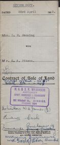
Contract of sale of land dated 23rd April, 1953 between Mrs. L.M. Manning (seller) and Mr. L.A. Pitson (buyer) for land situate 134 Bannister Street, Bendigo being north-east of and about 195 links from allotment 503 section K described in right to occupy residence area right No. 4612, together with 5-roomed weatherboard dwelling and all sundry. Price 1,350 pounds.organization, business, h.a. & s.r wilkinson real estate -
 Bendigo Historical Society Inc.
Document - H.A. & S.R. WILKINSON COLLECTION: CONDITION OF SALE
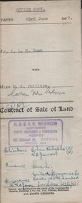
Contract of sale of land dated 23rd June, 1952 between Mr. J.L.C. Hunt (seller) and Miss D.A. Phillips for land being Lot 18 on plan of subdivision No. 14194, being part of Crown allotments 454A and 476 section H described in certificate of title volume 6110, folio 975 situate in Murray Street, Bendigo, together with 50roomed weatherboard dwelling and all sundry. Price 2,525 pounds.organization, business, h.a. & s.r wilkinson real estate -
 Bendigo Historical Society Inc.
Document - H.A. & S.R. WILKINSON COLLECTION: CONDITION OF SALE
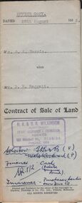
Contract of sale of land issued by H.A. Wilkinson dated 25th August 1953 between Mr. G. A. Harris (seller) and Mr. D.R. Raggatt for land being allotment 15Bsection 51B Parish of Sandhurst City and County of Bendigo described in right to occupy residence area No. 285 and situate No. 88 Old Violet Street Corner Lilac Street Bendigo, with weatherboard dwelling and all sundry. Price 3,800 poundsorganization, business, h.a. & s.r wilkinson real estate -
 Bendigo Historical Society Inc.
Document - ALBERT RICHARDSON COLLECTION: SHAFTS ALIENATED AND SITES RESERVED BY THE MINES DEPARTMENT
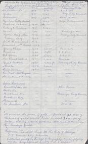
Handwritten one page table of information. On top of page ' Ref. derelict land in the City of Bendigo copied 17.4.62. Shafts alienated and sites reserved by the Mines Dept' List of mines, dates, depth of shaft, receiving body. For example: Londonderry, 1957, 2900 feet, Kindergarten. Reference: 'Derelict Land in the City of Bendigo' P.J. Rimmer and R.J. Johnston. Published jointly by the Dept of Geography, University of Sydney and The Geographical Society of NSW.Albert Richardsonbendigo, mining, derelict land reused -
 Bendigo Historical Society Inc.
Document - H.A. & S.R. WILKINSON COLLECTION: CONTRACT OF SALE
This business was owned by father and son, Henry Archibald Wilkinson and Samuel Ronald "Ron" Wilkinson. Henry (1882-1954) was born in Shepparton and died in Bendigo. He was married to Grace Hovendon in 1908. Samuel Ronald "Ron" (1914-1995), Henry's son, was married to Florence Jean McKerlie in 1937.Contract of sale of land dated 24th October, 1956 between D.E. Thomas & G.L. Thomas (sellers) and K.P. Robertson (buyer) part of Crown allotment 228A and 228B section A being the whole land described in certificate of title volume 6230 folio 888 and situate at the corner of Creeth and Arms Streets, Long Gully, together with all improvements thereon and all lines, blinds and light fittings. Price 2,300 poundsorganization, business, h.a. & s.r wilkinson real estate -
 Bendigo Historical Society Inc.
Document - H.A. & S.R. WILKINSON COLLECTION: CONTRACT OF SALE
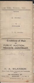
This business was owned by father and son, Henry Archibald Wilkinson and Samuel Ronald "Ron" Wilkinson. Henry (1882-1954) was born in Shepparton and died in Bendigo. He was married to Grace Hovendon in 1908. Samuel Ronald "Ron" (1914-1995), Henry's son, was married to Florence Jean McKerlie in 1937.Conditions of sale by public auction dated 25th January, 1930 between A. Mooney (seller) and T.C. Smith (buyer) for land situate Allingham Street, Golden Square, being described in certificate of registration as residence area No. 20503, together with all buildings on said land. Price 26 pounds. Also account from The Bendigo Advertiser to H.A. Wilkinson for advertising dated 28 January, 1930 for 1 pound 10 shillings.organization, business, h.a. & s.r wilkinson real estate -
 Bendigo Historical Society Inc.
Document - H.A. & S.R. WILKINSON COLLECTION: CONTRACT OF SALE
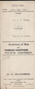
This business was owned by father and son, Henry Archibald Wilkinson and Samuel Ronald "Ron" Wilkinson. Henry (1882-1954) was born in Shepparton and died in Bendigo. He was married to Grace Hovendon in 1908. Samuel Ronald "Ron" (1914-1995), Henry's son, was married to Florence Jean McKerlie in 1937.Conditions of sale by private contract dated 31st May, 1935 between Mr. E.T. Thomas (seller) and Mrs. A.M. Smyth for land, as fenced, situate corner Hargreaves and Wattle Streets, Bendigo, being Crown allotment 25 section 97C described in certificate of title volume 1662 folio 332318. Also land adjoining the above, together with 6-roomed weatherboard dwelling and all sundry. Price 435 pounds.organization, business, h.a. & s.r wilkinson real estate -
 Bendigo Historical Society Inc.
Document - H.A & S.R. WILKINSON COLLECTION: CONTRACT OF SALE
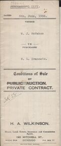
This business was owned by father and son, Henry Archibald Wilkinson and Samuel Ronald "Ron" Wilkinson. Henry (1882-1954) was born in Shepparton and died in Bendigo. He was married to Grace Hovendon in 1908. Samuel Ronald "Ron" (1914-1995), Henry's son, was married to Florence Jean McKerlie in 1937.Conditions of sale by private contract dated 5th June, 1936 between W.J. McMahon (seller) and N.L. Svanosio (buyer) for land situate No. 64 Neale Street, Bendigo being parts of Crown allotments 200 and 201A section H, being the whole of the land remaining untransferred in certificate of title volume 4300 folio 859955, together with 5-roomed weatherboard dwelling and all sundry. Price 400 pounds.organization, business, h.a. & s.r wilkinson real estate -
 8th/13th Victorian Mounted Rifles Regimental Collection
Photograph
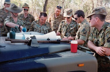
The Dibb Report into mainland defence of Australia,1986, among other things identified the requirement for protection of key assets in Northern Australia and the possibility of involving Army Reserve (Ares) units in this thus releasing regular forces for offensive operations. Dibb also pointed out that this defined role would result in a huge lift in Ares morale. In June 1988, the 3rd Division (3Div) conducted a Tactical Exercise without Troops (TEWT), Exercise ‘Distant Trumpet’ in the Katherine- Darwin area to study problems associated with defence against low level incursions against Tindal RAAF Base. Exercise ‘Northern Explorer’ followed in October of that year when units of the 3Div including A Squadron 8/13 Victorian Mounted Rifles sent patrol groups to get a first taste of environment and conditions. Post-Exercise reports had to include recommendations re: health, equipment and adaptation of Standing Operating Procedures (SOPs) in preparation for the new role deploying to Northern Australia. The first deployment by 8/13 Victorian Mounted Rifles was in 1988. Deployments continued in following years. In September 1993, 3 Troop (Wangaratta) VMR Squadron 4/19 PWLH commanded by Captain Kelvin Robertson deployed to NT. The training began with airfield defence at Tindal followed by a 1000km recon into Arnhem Land in four Landrovers. The troop reported on the conditions of the roads, airfields, bridges (mainly causeways) resources such as fuel supplies in the towns and infrastructure. Each troop taking different route. 3 Troop had the Northern route through Kakadu National park across the East Alligator River to Oenpelli then to Maningrida and Ramangining and south to the Central Arnhem Road and back to Tindal Air force Base. Colour photograph of group of soldiers of VMR Squadron 4/19Prince of Wales's Light Horse studying maps on bonnet of Land Rover during annual exercise in Northern Territory 1994.Major M. Annett wearing slouch hat, Sergeant Gary Wynn,without hat,,on his left. -
 Kew Historical Society Inc
Plan - Subdivision Plan, Jas R Mathers Son & McMillan, Clifton Estate, Kew, c. 1916
Pru Sanderson, in her groundbreaking ‘City of Kew Urban Conservation Study : Volume 2 - Development History’ (1988), summarised the periods of urban development and subdivisions of land in Kew. The periods that she identified included 1845-1880, 1880-1893, 1893-1921, 1921-1933, 1933-1943, and Post-War Development. These periods were selected as they represented periods of rapid growth or decline in urban development. An obvious starting point for Sanderson’s groupings involved population growth and the associated economic cycles. These cycles also highlighted urban expansion onto land that was predominantly rural, although in other cases it represented the decline and breakup of large estates. A number of the plans in the Kew Historical Society’s collection can also be found in other collections, such as those of the State Library of Victoria and the Boroondara Library Service. A number are however unique to the collection.The Kew Historical Society collection includes almost 100 subdivision plans pertaining to suburbs of the City of Melbourne. Most of these are of Kew, Kew East or Studley Park, although a smaller number are plans of Camberwell, Deepdene, Balwyn and Hawthorn. It is believed that the majority of the plans were gifted to the Society by persons connected with the real estate firm - J. R. Mathers and McMillan, 136 Cotham Road, Kew. The Plans in the collection are rarely in pristine form, being working plans on which the agent would write notes and record lots sold and the prices of these. The subdivision plans are historically significant examples of the growth of urban Melbourne from the beginning of the 20th Century up until the 1980s. A number of the plans are double-sided and often include a photograph on the reverse. A number of the latter are by noted photographers such as J.E. Barnes.The Clifton Estate was an ambitious subdivision. It included 61 allotments bordering Cotham and Park Hill Roads, and Florence and Adeney Avenues. It is difficult to ascertain the exact year when the ‘Clifton Estate’ was surveyed, subdivided and first auctioned. The uncertainty may be due to allotments being released during the First World War. The subdivision took its name from the house ‘Clifton’ (lot 5) on the corner of Adeney Avenue and Cotham Road. The outline of Clifton (since demolished) and the extent of its land following the subdivision are represented on the plan. The auctioneers have also shown ‘Maryfield’ and ‘Wimba’, the neighbouring properties in Cotham Road, on the plan."B"subdivision plans - kew, clifton estate, cotham road, adeney avenue, florence avenue, park hill road -
 Ballan Shire Historical Society
Map - Map. Korweinguboora, Department of Lands and Survey, Korweinguboora. Counties of Talbot and Grant
A map of the Korweinguboora area showing roads, forests, railway lines and properties with the owners names.The inclusion of the names of landowners is of significance and value to historians.A map of the Korweinguboora area showing land subdivisions and names of owners and other physical features. There is a scale in chains. No date is certain but it could be 1902. The map has been repaired with sellotape.There are various pencil annotations but the are difficult to read.talbot, moorarbool west, wombat, bullarto, korweinguboora, moorarbool east, dean, wombat state forest, barkstead -
 Glenelg Shire Council Cultural Collection
Photograph - Photograph - aerial view of Portland, c. 1954
Black and white aerial photograph of coastline around Portland. Black border, scale all sides, 5 rows of 3 't' at regular intervals. Ocean on left, land on rightFront: '607 - 54 ' - handwritten, white, border 'RUN 7' 'PORTLAND', printed, white, borderaerial photography, central portland, portland harbour, south west coastline -
Glenelg Shire Council Cultural Collection
Photograph - Photograph - aerial view of Portland, c. 1954
Black and white aerial photograph of coastline around Portland. Black border, scale all sides, 5 rows of 3 't' at regular intervals. Ocean at right, land on left.Front: '820 - 7' -- handwritten, white, lower border 'RUN 5' 'PORTLAND', printed, white, lower borderaerial photography, central portland, portland harbour, south west coastline -
Glenelg Shire Council Cultural Collection
Photograph - Photograph - aerial view of Portland, c. 1954
Black and white aerial photograph of coastline around Portland. Black border, scale all sides, 5 rows of 3 't' at regular intervals. 50/50 land and oceanFront: '607 - 51 ' - handwritten, white, border 'RUN 7' 'PORTLAND', printed, white, borderaerial photography, central portland, portland harbour, south west coastline -
Glenelg Shire Council Cultural Collection
Photograph - Photograph - aerial view of Portland, c. 1954
Black and white aerial photograph of coastline around Portland. Black border, scale all sides, 5 rows of 3 't' at regular intervals. 75/25 ocean to landFront: '784-146 ' - handwritten, white, border 'RUN - 7 A PORTLAND', printed, white, borderaerial photography, central portland, portland harbour, south west coastline -
Glenelg Shire Council Cultural Collection
Photograph - Photograph - aerial view of Portland, c. 1954
Black and white aerial photograph of coastline around Portland. Black border, scale all sides, 5 rows of 3 't' at regular intervals. 60/40 land to ocean.Front: '607 - 93 ' - handwritten, white, border 'RUN - 6 PORTLAND', printed, white, borderport of portland archives, aerial photography, portland harbour, south west coastline -
Glenelg Shire Council Cultural Collection
Photograph - Photograph - Aerial photograph of coastline, Portland Victoria, c. 1954
Black and white aerial photograph of coastline around Portland. Black border, scale all sides, 5 rows of 3 't' at regular intervals. 80/20 ocean to landFront: '784 - 147 ' - handwritten, white, border 'RUN 7 A PORTLAND', printed, white, border -
Glenelg Shire Council Cultural Collection
Photograph - Photograph - aerial view of Portland, c. 1954
Black and white aerial photograph of coastline around Portland. Black border, scale all sides, 5 rows of 3 't' at regular intervals. 90/10 ocean to landFront: '784 - 148'- handwritten, white, border 'RUN 7 A PORTLAND', printed, white, borderaerial photography, central portland, portland harbour, south west coastline -
Glenelg Shire Council Cultural Collection
Photograph - Photograph - aerial view of Portland, c. 1954
Black and white aerial photograph of coastline around Portland. Black border, scale all sides, 5 rows of 3 't' at regular intervals. 20% ocean, 80% land.Front: '820 -51' - handwritten, white, border 'RUN 6' 'PORTLAND', printed, white, borderaerial photography, central portland, portland harbour, south west coastline -
Glenelg Shire Council Cultural Collection
Photograph - Photograph - 'My Portland' Photographic project (2007), 2007
Collection of Photographs from the 'My Portland' project, curated by Carmel Wallace for the Portland Library in 2007. Images include people, buildings, the Port, family life, land marks, ect. -
 Orbost & District Historical Society
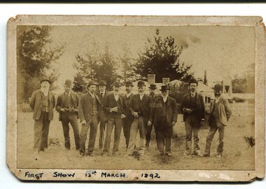
Photograph, March 13 1892
This photograph shows members of the first Orbost Agricultural Show committee.. The first meeting to form an Agricultural society in Orbost was convened by the then Orbost Progress Association and held in the Mechanics Hall on Saturday, 10th October 1891. Its first show was held on 3rd March 1904...on a site alongside the Bonang Road where the present Golf Club stands. It is currently held at the Recreation Reserve at Newmerella. (Ref: In Times Gone By-Deborah Hall) This item is associated with the Orbost Agricultural Society 's Annual Show which has been a major event in Orbost for over a century. Agricultural shows are an important part of cultural life in small country towns and the Orbost Show is an integral part of Orbost 's agricultural history.A sepia photograph of eleven men, wearing suits and waistcoats, standing on a vacant block of land. In the background are houses among tress. The photograph is mounted on grey card - rectangular with rounded corners.on back -"Toby Nixon" on front - "First Show 13th March 1892"orbost-agricultural-society annual-show-orbost agriculture-orbost -
Federation University Historical Collection
Book, Historic Sites Survey: North Central Study Area, 1979, 1979
The North Central Study Area included the Shires of Avoca, Bet Bet, east Loddon, Goulburn, Untly, Kara Kara, Korong, Maldon, Marong, Metcalfe, McIvor, Newstead, Strathfieldsaye, Stawell, Talbot, Clunes, Tullaroop and Waranga. 153 page book with white plastic binding. It is an historic sites survey for the North Central Study Area commissioned by the Land Conservation Council, the Ministry for COnservation and the Australian Heritage Commission. castlemaine, mount alexander goldfield, maldon, percydale, warrenmang, moliagul, tarnagulla, stuart mill, the whipstick, whroo, rushworth, graytown ironbark forest, st arnoaud, new bendigo, landsborough, inglewood, kurting, wedderburn, wehla, kooroora, langham flat, mcintyre, rheola, diamond hill, fosterville, coliban water works, green gully, newstead, muckleford forest, costerfield, graytown, bailieston, waranga irrigaiton system, eucalyptus distillery, mia mia bridge, korokubeal township researce, concegella slate quarry, chewton, fryerstown, kingower, timor, talbot, majorca, carisbroook, clunes, st arnaud, taradale, icomos, dunolly, limestone, castlemaine slate quarry, harcourt granite, taradale railway viaduct, loddon united waterworks trust, gouldburn weir, carisbrook lock-up, history of tree planting in streets, history of public reserves, r.u. nicholls nurseryman, thomas lang, francis moss, ballarat botanical gardens, ballarat school of mines botanical gardens, lake wendouree, victoria park, ballarat, muont holled smith, ballaarat old cemetery planting, eastern oval, ballarat east botanical gardens, ballarat east town hall gardens, eureka stockade reserve, ballarat observatory plantings, yarrowee creek plantings, yarrowee bluestone channels, ballarat woollen mill, band and albion mullock heap, black hill plantings, yarrowee creek channels, canadian creek channel, specimen vale channel, poverty point reserve, union jack reserve buninyong, imperial mine, buninyong, victoria street plantings, bridge mall, sturt street gardens, ballarat avenue of honour plantings, white flat oval plantings, camp street, elms, burnt creek -
Glenelg Shire Council Cultural Collection
Photograph - Photograph - Portland Harbour, Jun-92
Port of Portland Authority ArchivesFront: Back- 7/92- Blue pen Back: Testport of portland archives, reclamation area -
Glenelg Shire Council Cultural Collection
Photograph - Photograph - Portland Harbour, Jul-92
Port of Portland Authority ArchivesFront: Back- 7/92- Blue biroport of portland archives, portland maritime discovery museum, crane, portland harbour -
Bendigo Historical Society Inc.
Map - CAMPBELL COLLECTION: BENDIGO & DISTRICT MAPS
Map. Bendigo Whipstick, Scale 40 chains to 1 inch, Forests Commission Victoria, map N0.3, legend for roads and land and forest. (number 371 in map cupboard 1)map, bendigo, country lands -
Bendigo Historical Society Inc.
Document - ALLOTMENTS SOLD BY PUBLIC AUCTION 1ST JUNE 1837 MELBOURNE
Large copy of the first land auction in Melbourne on June the first 1837. Melbourne - Port Phillip, allotments sold by public auction with the name of the purchasers and of the prices. June 1st 1837.victoria, history, land -
Port Melbourne Historical & Preservation Society
Photograph - Aerial view of Port Melbourne, 1993
Two large colour aerial view photographs of Port Melbourne piers and surrounds: .01 - View from land .02 - View from the bay Abel Tasman is at Station Pierpiers and wharves - station pier, piers and wharves - princes pier, piers and wharves - webb dock, built environment - domestic, transport - shipping, abel tasman, port melbourne primary school, missions to seamen -
 Bendigo Historical Society Inc.
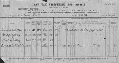
Document - GLENYS MCKITTERICK COLLECTION: WILLIAM BEEBE DOCUMENTS
Land Tax Assessment Act 1910-1914.William Beebe A/10062, 1915/16. Sandhurst N.D.T.E. Coy, Bendigo Gas Coy, Bendigo Pottery, Bendigo M.P.& B.Soc.person, bendigo, william beebe, beebe, land tax assessement. -
 Bendigo Historical Society Inc.
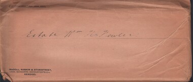
Document - MCCOLL, RANKIN AND STANISTREET COLLECTION: ESTATE OF WILLIAM HENRY FOWLER - KERANG, 1934/39
Documents: envelope contains - 1935 Share farmer agreement, 1935 Lease, 1934 Lease agreement for grazing land Kerang, 1934 Lease agreement Mr Jas Thompson & Ors.MCCOLL RANKIN AND STANSISTREETorganization, business, gold mining - legal, mccoll rankin and stansistreet -
Bendigo Historical Society Inc.
Document - HARRY BIGGS COLLECTION: DOCUMENT ABOUT PIECE OF LAND
Document. Harry Biggs Collection. This piece of card has some writing on it which appears to be about a piece of land. It is only a fragment so is difficult to know what it is all about.cottage, miners, harry biggs collection, wade street golden square, foggitt & jones, roberts osborne & co. pty. ltd. (ham & bacon curers)