Showing 123961 items
matching main-road
-
 Mt Dandenong & District Historical Society Inc.
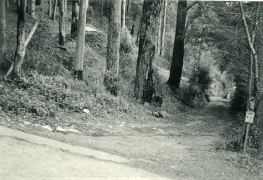
Photograph, The Wagon Road, c1970s
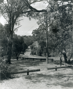
The old Wagon Road built 1876-1878. This photograph has a detailed inscription on the back handwritten by John Lundy-Clarke in 1974.The Wagon Road. Built 1876 – 8. The first settler’s road in the Ranges as apart from Dray Tracks. Was built through Jeeves Selection, Crown Allotment “C” named “Jeeves saddle” and removed the monopoly held over travel through the Gap. jeeves saddle, kalorama, road, wagon road, john lundy-clarke -
 Eltham District Historical Society Inc
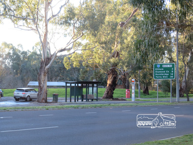
Photograph, Liz Pidgeon, Heritage Excursion; Eltham Lower Park Walk and Talk, 1 July 2017, 1 July 2017
Main Road Eltham Newsletter No., 234, June 2017 Heritage Excursion - Saturday 1st July - Eltham Lower Park - Walk and Talk Eltham Lower Park has played an important part in the history of our area since the early days of European settlement when it was used by local residents as an informal racecourse. Prior to that its location at the junction of the Diamond Creek and the Yarra River made it an important meeting place for the Wurundjeri people. The park combines formal elements and sporting facilities with remnant bushland that is of environmental significance. It is home to sporting and horse riding clubs, popular play spaces and the Diamond Valley Miniature Railway, which attracts large numbers of visitors. The park will be the venue for our July excursion which will comprise a walk of about 3.5 km around the park and adjacent areas. Along the way we will discuss the history and natural history of the area. The path along the creek and the river provides a pleasant and scenic walk. This walk on Saturday 1st July is about 3.5 km in length and will take 2 to 2.5 hours. It will start at 2pm at the Main Road car park at the front of the park. (Melway ref 21 H 10). Born Digitalheritage excursion, activities, eltham district historical society, eltham lower park, road sign, bus stop, main road -
 Stawell Historical Society Inc
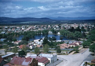
photograph - Slides, Ian McCann, Main St, Victoria St & St Grorges St with Cato Lake in background, 1976 - 1984
Colour Photograph of Main St, Victoria St & St Georges Street with Cato Lake In the Background -
 Stawell Historical Society Inc
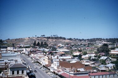
Slide, Ian McCann, Main Street Toward Big Hill
High angle view of Main Street from Town Hall looking toward Big Hill.stawell buildings -
 Buninyong & District Historical Society
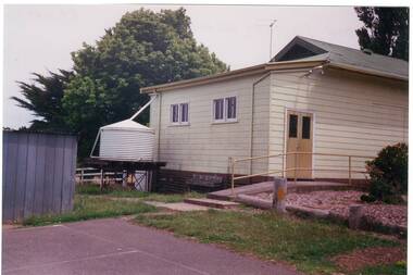
Photograph - Colour photograph, Colour photograph of the rear of the main building of Yendon Primary School 1994
Yendon Primary School operated as a State School from 1877 and ceased operating in 1993. The School initially operated as the Buninyong East Common School from 1864.The children of railway workers from the Ballarat- Geelong railway would have formed much of the opening enrolment of the school.Colour photograph showing the rear of the former main school building of Yendon Primary and part of the playground.Yendon Primary School 1994education, yendon, state schools -
 Federation University Bookplate Collection
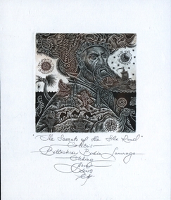
Work on paper - Bookplate, The Secrets of the Silk Road
After a quiet period, interest in bookplates in Australia began to increase in the early 1970s, Entrepreneurial art and book collectors such as Edwin Jewell and others commissioned multiple Bookplate designs from a range of well known fine artists. At a 1997 meeting in Melbourne of the Ephemera Society of Australia Edwin Jewell and others announced the formation of the Australian Bookplate Society. The society was instrumental in promoting the art of the bookplate through establishment of the Australian Bookplate Design competition. The competition includes a design award for secondary schools students.Venetian prince set against eastern buildings, seas, gondolas and ships with eastern architecture, symbols and camels. A dragon and elephant in prince's diadem and hair. Library details surrounding sun and moon either side of main figure all in bi-coloured inks.Inscribed beneath image, "The Secrets of the Silk Road" Ex Libris Biblioteca Bodio Lambnago - Etching Natalija 2019 -
 Glenelg Shire Council Cultural Collection
Photograph - Photograph - Main Breakwater construction, Portland, 30/06/1953
Port of Portland Authority ArchivesBack: Purple PHT Stamp - Print No 4/17 Neg. No 158 Date taken 30.6.53 Subject - Main Breakwater East Sideport of portland archives, main breakwater, construction, portland harbour, harbour development, lady bay -
 Charlton Golden Grains Museum Inc
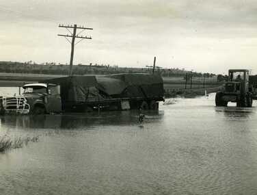
Photograph, Cameron, Ian, Road Transport run off road in flood water 1971, 12/11/1971
Road transport run off Calder Highway in 1971 flood water. Shire grader trying to remove truck. Used in Charlton Tribune Nov 12th, 1971.B/W photo of road transport run off Highway in flood water. Shire grader trying to remove truck.flood, calder highway, charlton -
 Hawthorn Historical Society
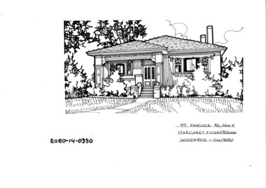
Drawing - Property Illustration, 49 Havelock Road, Hawthorn East
'After training as a Cartographic Draftsman within the mining industry, I worked as a property illustrator for real estate firms in the eastern suburbs of Melbourne for 23 years from 1983. I initially photographed houses with a Polaroid camera and made a 'thumbnail' sketch while there. The photos were used to scale off a sketch in pencil and then that sketch was overlaid with drafting film and the 'pen and ink' completed. The pens I used were the Rotring ‘Rapidigraph’ drafting pens. The ink was also made by Rotring (German).The film was ‘Rapidraw’, polyester drafting film, double matte. It takes a very fine line and doesn’t bleed. As well as house sketches, there were often floor plans and site plans ordered. Aerial sketches were ordered when the property needed an overall view.' (Margaret Picken, 2020)This property illustration is one of a series created by Margaret Picken for a range of real estate agents in Melbourne between c. 1983 and c. 2006. Each work is signed and dated by the artist.Gift of Margaret Picken, 2020pen and ink architectural drawing on drafting film. Dimension 255x165 Inscription: 49 HAVELOCK ROAD, HAW E Margaret Picken ©2000 WOODARDS -C'WELL49 HAVELOCK ROAD, HAW E Margaret Picken ©2000 WOODARDS -C'WELLartist - margaret picken 1950- -
 Whitehorse Historical Society Inc.
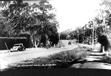
Photograph, Blackburn Road, Blackburn
black and white photo of Blackburn Road, Blackburn.2 copies of black and white photo of Blackburn Road, Blackburn.blackburn road, 1930s - 1940s ? -
![Newspaper Clipping - Digital Image, Bridge-over-rail job to cost $254,000, 1974 [Main Street Greensborough], 24/09/1974](/media/collectors/4f729f5697f83e03086015b8/items/5eb5f55721ea671f1807c4cf/item-media/5eb5f5e021ea671f18088f90/item-fit-380x285.jpg) Greensborough Historical Society
Greensborough Historical SocietyNewspaper Clipping - Digital Image, Bridge-over-rail job to cost $254,000, 1974 [Main Street Greensborough], 24/09/1974
In 1974 the proposed road over rail bridge in Main Street Greensborough was estimated to cost $254,000. The reconstruction of the bridge was necessary for the duplication of the rail line between Macleod and Greensborough.News clipping, black and white text. hurstbridge rail line, greensborough station, main street greensborough -
 Greensborough Historical Society
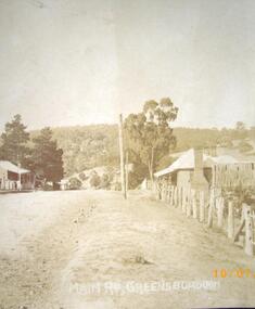
Photograph - Digital image, Main Street Greensborough, 1902
Main Street Greensborough shown as an unmade road, circa 1910. Photographs from the collection of Peter Blackbourn, a descendant of the Chapman Stock family. Annotations to photos by Peter Blackbourn.Digital copy of black and white photograph.peter blackbourn, main street greensborough -
 Whitehorse Historical Society Inc.
Photograph, Deep Creek Road, Mitcham, 1/09/2000 12:00:00 AM
Black and white photo of View looking North along Deep Creek Road, Mitcham, taken from Car Park of Schwerkolt Cottage and Museum Complex.mitcham -
 Glen Eira Historical Society
Album - Album page, St Mary's Church Hall, Glen Eira Road, Circa 1972
This photograph is part of the Caulfield Historical Album 1972. This album was created in approximately 1972 as part of a project by the Caulfield Historical Society to assist in identifying buildings worthy of preservation. The album is related to a Survey the Caulfield Historical Society developed in collaboration with the National Trust of Australia (Victoria) and Caulfield City Council to identify historic buildings within the City of Caulfield that warranted the protection of a National Trust Classification. Principal photographer thought to be Trevor Hart, member of Caulfield Historical Society. Most photographs were taken between 1966-1972 with a small number of photographs being older and from unknown sources. All photographs are black and white except where stated, with 386 photographs over 198 pages. The Jubilee School on the corner of Hood Crescent and Glen Eira Road was built in 1887 AD to commemorate Queen Victoria’s Jubilee.Victorian Heritage Database https://vhd.heritagecouncil.vic.gov.au/places/43705 The former St Mary's Jubilee School is locally significant as an early purpose built church school, associated with St Mary's Church. Its use of polychrome brick is locally conspicuous whilst the adoption of the Gothic Style not only underlines its Christian foundations but relates to the comparable schools of the Public Works Department of the same period.Page 57 of Photograph Album with four exterior photographs (2 portrait and 2 landscape) of St Mary's Church Hall. Bottom right photograph is a photo of a photo.Hand written: St Mary's Church Hall - Glen Eira Road [top left] / Neg 233 8 Oct 1966 [under top left photo] / 3 Sept 1972 [under bottom left photo] / bottom right photo titled "St Mary's Sunday School" / 57 [bottom left] trevor hart, 1880's, elsternwick, glen eira road, st kilda east, church of england, st mary's, caulfield north, st mary's anglican church hall, hood crescent, jubilee school, polychrome brickwork, curved windows, church hall, queen victoria’s jubilee, victorian, sunday schools, st mary's jubilee school, gothic style -
 Glen Eira Historical Society
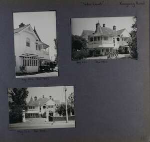
Album - Album page, Tudor Court, Kooyong Road, Dec 1972
This photograph is part of the Caulfield Historical Album 1972. This album was created in approximately 1972 as part of a project by the Caulfield Historical Society to assist in identifying buildings worthy of preservation. The album is related to a Survey the Caulfield Historical Society developed in collaboration with the National Trust of Australia (Victoria) and Caulfield City Council to identify historic buildings within the City of Caulfield that warranted the protection of a National Trust Classification. Principal photographer thought to be Trevor Hart, member of Caulfield Historical Society. Most photographs were taken between 1966-1972 with a small number of photographs being older and from unknown sources. All photographs are black and white except where stated, with 386 photographs over 198 pages. Sands & McDougalls directory of Victoria : 1970 gives address as 141 Kooyong Road, Caulfield North. "Caulfield's Building Heritage" p67 includes that this mansion was originally called Fairhaven, built for George Hope, a dairy farmer. He changed the name to Tudor Court in 1915 when he moved his dairy to Cranbourne.Page 116 of Photograph Album with three photographs (one portrait and two landscape) of different views of Tudor Court in its garden. Handwritten: "Tudor Court" Kooyong Road [top right] / Neg 252 Dec 1972 [under top left photo] / Neg 251 Dec 1972 [under top right photo] / Neg 253 Dec 1972 [under bottom left photo] / 116 [bottom right]trevor hart, caulfield north, kooyong road, mansion, verandah, tudor court, george hope, terracotta tiles, terracotta roof, arched windows, port cochere, square bay window, timber balustrade, columned balcony, receptions, fairhaven, arcare caulfield aged care, 1910's, spire, ridge capping, conical roof, verandahs, victorian architectural style, tudor style, queen anne style, lead lights windows, shingle roofs -
 Whitehorse Historical Society Inc.
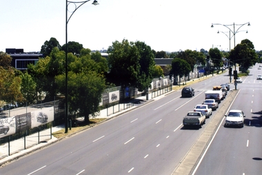
Photograph, Whitehorse Road, Blackburn, 2012
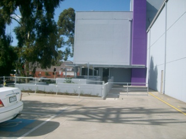
The property on the left of Whitehorse Road was once the Cottees factory. It later became the Leader Newspaper headquarters. It was next owned by Lexus Motor Sales and is now used (2014) as a storage yard with the eastern end used by Leader Newspaper as a staff car park.Coloured photograph of Whitehorse Road, Blackburn - 2012. Cars waiting to turn right into Surrey Road.whitehorse road, blackburn, roads -
 Glen Eira Historical Society
Album - Album page, Rosemont, 112 Kooyong Road, Circa 1972
This photograph is part of the Caulfield Historical Album 1972. This album was created in approximately 1972 as part of a project by the Caulfield Historical Society to assist in identifying buildings worthy of preservation. The album is related to a Survey the Caulfield Historical Society developed in collaboration with the National Trust of Australia (Victoria) and Caulfield City Council to identify historic buildings within the City of Caulfield that warranted the protection of a National Trust Classification. Principal photographer thought to be Trevor Hart, member of Caulfield Historical Society. Most photographs were taken between 1966-1972 with a small number of photographs being older and from unknown sources. All photographs are black and white except where stated, with 386 photographs over 198 pages.From Victorian Heritage Database citation for Rosemont HO124 - 112 Kooyong Road Caulfield North https://vhd.heritagecouncil.vic.gov.au/places/35588 Rosemont'' is situated at no.112A Kooyong Road, Caulfield North and was built in 1869 for Godfrey Howitt, physician, president and honorary physician of the Melbourne Benevolent Society, Council member of the University of Melbourne and founding vice president of the Royal Society of Victoria. It is historically significant (Criterion A) as an early and substantial villa residence demonstrating Caulfield's early attraction as a residential retreat for Melbourne's elite. This significance is enhanced by the associations of the place with Godfrey Howitt and later James Grice, National Bank chairman and owner of "Stonnington" in Glenferrie Road, Malvern and Thomas King, councillor and successful negotiator for the extension of the electric tramway system to the Municipality.Page 110 of photograph album with 4 photos (portraits) of varying views of Rosemont's exterior and garden.Handwritten: "Rosemont" 112 Kooyong Road [top right] / Neg 97 1972 / [under top right photo] / 110 [bottom right]trevor hart, caulfield, john bakewell, francis mcdonnell, gabled slate roofs, rosemont, caulfield north, kooyong road, 1860's, godfrey howitt, james grice, thomas king, villa residence, decorative brickwork, curved windows, bay window, garden, victorian style, mansions, polychrome bricks, porches, arches, parapets, verandahs, slate roofs -
 Ringwood and District Historical Society
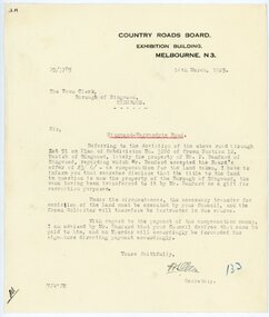
Letter, From Country Roads Board re compensation for road-widening land from Mr Bamford in 1929
1929 saw the establishment of the Ringwood Bowls Club initially located on the land now occupied by the Eastland Shopping Centre. It moved to its current location in Loughnan Road, Ringwood in 1997.From Country Roads Board re compensation for road-widening land from Mr Bamford. Dated 14th March 1929.city of ringwood bowls club, ringwood bowling club, ringwood bowls club, lawn bowls, bowling -
 Lakes Entrance Historical Society
Photograph, Punt Road Metung Victoria, 1/06/1999 12:00:00 AM
Also a colour photograph looking South from Punt Road Metung 04460.1 10 x 15 cmColour photograph looking Northwest from Punt Road Metung Victoria. Also a colour photograph looking South from Punt Road Metung township, waterways, boats and boating, boardwalk -
 Eltham District Historical Society Inc
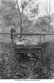
Photograph, The Rose Stereograph Company, Log Bridge, Eltham Road. Greensborough, c.1920
A woman stands at the end of a log bridge over a creek looking towards the south along the unsealed roadway. The sun illuminates her back. She is wearing a woollen knit beanie with edges rolled up, dark jacket and skirt, full length dark stockings and slip on dark leather shoes with raised heel, typical of the early 1920s. The creek is possibly feeding into the Karingal Yalloc. The direction of the road based on shadows is northwest as is the Eltham Road to Greensborough (present day Sherbourne, Karingal and St Helena roads). The creek is falling to the foreground so from south west to the north east, possibly feeding into the Karingal Yalloc, somewhere near presenet day Ramptons Road Reserve. This glass plate negative was used to manufacture postcards (1:1 printing) for commercial sale by the Rose Sterograph Company and its subsidiaries. George Rose founded the Rose Stereograph Company in 1880 and was joined by Herbert (Bert) Cutts in the early 20th Century. The pair formed a lifetime working partnership and strong personal friendship. Assisted by George’s two sons, Herbert George and Walter, and later by Neil Cutts, the Rose Stereograph Company continued its operations for more than 140 years. The company was initially built on stereographs, but as cinema took over and stereographs fell out of fashion, the Rose Stereograph Company developed Australia’s first commercially viable photographic postcard business. Specialising in postcards of iconic historical moments and significant landmarks, The Rose Stereograph Company became a staple of the Australian travel industry.This remarkable collection of glass plate negatives, transparencies, and postcards – arguably Australia’s most significant photography collection outside of public hands – has been passed down through the generations, surviving war, relocation, and the harsh Victorian climate. The historic Rose Stereograph collection is the culmination of George Rose’s dream of capturing and preserving precious moments in time and remains the legacy of the Rose and Cutts families. It is with great sadness that the Cutts family says goodbye to a collection that spans five generations and 140 years. The Cutts family understands that for these historically important pieces to rest with one family is to deny others the pleasure of their custodianship.Glass Plate Negative Size: 9.2 x 13.8 cmLog Bridge, Eltham Road, Greensborougheltham, postcard, travel, rose stereograph company, glass plate negative, creek, eltham road, greensborough, karingal road, karingal yallock, log bridge, sherbourne road, st helena road, women's fashion, rampton's road reserve, peter and elizabeth pidgeon collection -
 Mt Dandenong & District Historical Society Inc.
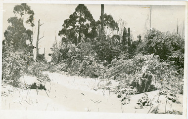
Photograph, Snowfall At Chalet Road, 1921
Postcard made for E. Woorich "Range View" Olinda showing Chalet Road in Olinda under snow in 1921.Printed on back in purple ink: E. Woorich "Range View" Olinda Handwritten in pen: 1921 snowfall at Chalet Road.range view nursery, e. woolrich, chalet road, snow, olinda -
 Bacchus Marsh & District Historical Society
Map, Plan of part of the road district of Bacchus Marsh circa 1856-1862
Local government in much of Victoria including the Bacchus Marsh area began with the formation of 'local committees'. These local committees could make representations to a Central Road Board regarding plans for road construction. Road construction and maintenance were seen as the essential tasks of these early local government authorities. By 1856 the local committee in Bacchus Marsh was constituted as the Bacchus Marsh Road District. This entity continued until 1862 when the name changed to the Bacchus Marsh and Maddingley Road District. This new entity lasted until 1871 when the local government authority in accordance with new statewide legislation became known as the Shire of Bacchus Marsh. The title of this plan being a plan of 'a portion of the road district of Bacchus Marsh' suggests that the plan was produced sometime between 1856 and 1862. The main purpose of this map was to shown the irrigable land in the district and the sources from which water for irrigation could be drawn. Bacchus Marsh was an early irrigation district in Victoria. Irrigation trusts were formed in the 1880s and 1890s to manage irrigation districts. But this was the culmination of many years of earlier attempts to construct irrigation systems in the Bacchus Marsh area and create a system to manage irrigation more broadly. This map dating from around 1856-1862 is an important cartographic document which provides evidence of how the early planning for irrigation was developing in the Bacchus Marsh region.A single page paper map showing a plan of part of the road district of Bacchus Marsh. The map is pasted into a bound volume containing 76 maps or plans in total. High resolution digital image stored on BMDHS computer network. bacchus marsh victoria maps, bacchus marsh road district, local government, road districts, irrigation -
 Vision Australia
Photograph - Image, Interior and exterior view of Vision Australia's office at 346 Macaulay Road, Kensington, April 2008
Interior and exterior view of Vision Australia's office at 346 Macaulay Road, Kensington.11 digital photographs of VA Macaulay Road Officevision australia, macaulay road kensington -
 St Kilda Historical Society
Photograph, St Kilda Road, c. 1960s
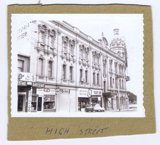
St Kilda Road (formerly High St), St Kilda. On right is corner of Alma Road. black and white photograph, original, unmounted, good condition -
Stawell Historical Society Inc
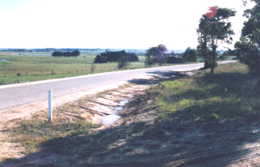
Photograph, Water storage tanks part of reservoir in reefs road -- Coloured
Coloured Photo showing two water storage tanks part of reservoir in reefs roadDirt road in foreground power pole and water tanks. stawell -
 Tarnagulla History Archive
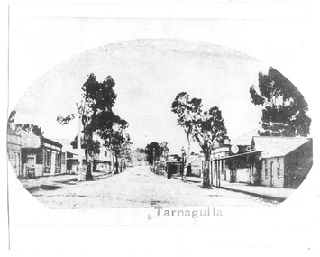
Photograph of Commercial Road, Tarnagulla looking south from King Street, Commercial Road, Tarnagulla Looking South from King Street, c1930, circa 1862 - 1900
Murray Comrie Collection. This is a reasonable copy of an older original. Copy probably made by Murray Comrie in the 1970s. Monochrome photograph. View of Commercial Road Tarnagulla looking south from around King Street. At right is Victoria Hotel next to a weatherboard building at far right.Printed caption on original is 'Tarnagulla'.tarnagulla, commerce, stores, shopping, shops, hotels, victoria hotel and theatre, buildings, commercial road, main street -
 Eltham District Historical Society Inc
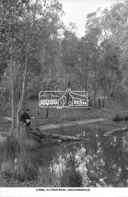
Photograph, The Rose Stereograph Company, A Pool, Eltham Road, Greensborough, c.1920
A boy of about ten years of age sits on the end of a fallen tree, which is resting in a natural pool in bushland. He is holding a stick gazing into the pool waters. He appears to be dressed in a schoolboy's uniform with close fitting short peaked cap, dark scarf or long sleeved jumper with polo neck and what appears to be a logo on the left breast, the ends of the sleeves turned over, dark shorts and dark long socks with ankle height lace up leather boots. The pool is located on the Eltham Road to Greensborough (present day Sherbourne, Karingal and St Helena roads) and is possibly part of the Karingal Yalloc somewhere near present day Ramptons Road Reserve. This glass plate negative was used to manufacture postcards (1:1 printing) for commercial sale by the Rose Sterograph Company and its subsidiaries. George Rose founded the Rose Stereograph Company in 1880 and was joined by Herbert (Bert) Cutts in the early 20th Century. The pair formed a lifetime working partnership and strong personal friendship. Assisted by George’s two sons, Herbert George and Walter, and later by Neil Cutts, the Rose Stereograph Company continued its operations for more than 140 years. The company was initially built on stereographs, but as cinema took over and stereographs fell out of fashion, the Rose Stereograph Company developed Australia’s first commercially viable photographic postcard business. Specialising in postcards of iconic historical moments and significant landmarks, The Rose Stereograph Company became a staple of the Australian travel industry.This remarkable collection of glass plate negatives, transparencies, and postcards – arguably Australia’s most significant photography collection outside of public hands – has been passed down through the generations, surviving war, relocation, and the harsh Victorian climate. The historic Rose Stereograph collection is the culmination of George Rose’s dream of capturing and preserving precious moments in time and remains the legacy of the Rose and Cutts families. It is with great sadness that the Cutts family says goodbye to a collection that spans five generations and 140 years. The Cutts family understands that for these historically important pieces to rest with one family is to deny others the pleasure of their custodianship.Glass Plate Negative Size: 9 x 14 cmA Pool, Eltham Road, Greensborougheltham, postcard, travel, rose stereograph company, glass plate negative, eltham road, greensborough, karingal road, karingal yallock, sherbourne road, st helena road, rampton's road reserve, schoolboy, peter and elizabeth pidgeon collection -
 Bacchus Marsh & District Historical Society
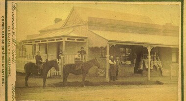
Photograph, Edward's Butchers Shop Main Street Bacchus Marsh 1883
This Butcher’s shop was opened by J. Edwards. It adjoined G. Dickie’s bakery in Main Sreet. Later occupants of the premises included Beardmore, Clark, Bence and Ramsey.Small sepia 'carte de viste' style unframed photograph on card with gold border framing photograph. Housed in the album, 'Photographs of Bacchus Marsh and District in 1883 by Stevenson and McNicoll'. The image depicts a butcher’s premises in Main Street Bacchus Marsh. The butcher and another man stand on the verandah in front of the shop. Behind them meat for sale is seen hanging from a rack. Two other people stand under the verandah at the front of the dwelling which runs along the side of the shop. In the street are two other people, one of whom holds a delivery basket, mounted on horses.Printed On the front: Stevenson & McNicoll. Photo. 108 Elizabeth St. Melbourne. COPIES CAN BE OBTAINED AT ANY TIME. On the back: LIGHT & TRUTH inscribed on a banner surmounted by a representation of the rising sun. Copies of this Portrait can be had at any time by sending the Name and Post Office Money Order or Stamps for the amount of order to STEVENSON & McNICOLL LATE BENSON & STEVENSON, Photographers. 108 Elizabeth Street, MELBOURNE.stevenson and mcnicoll 1883 photographs of bacchus marsh and district, butchers, butcher shops -
 Greensborough Historical Society
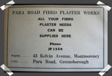
Advertisement - Digital image, Para Road Fibro Plaster Works, 1970s
Advertisement in the local paper for Para Road Fibro Plaster Works, of 191 Para Road Montmorency, 1970sPart of a collection of miscellaneous advertisements for businesses in Greensborough and surrounding areas.Digital copy of newspaper advertisement.para road fibro plaster works, para road montmorency -
 Surrey Hills Historical Society Collection
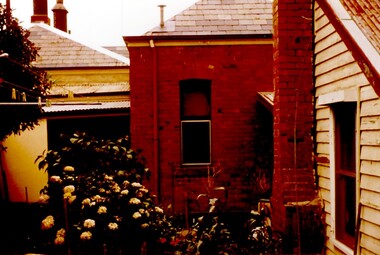
Photograph, Tavistock at 192 Union Road, 1978
The date is approximate. Tavistock was built c1890. In 1897 it was the home of the Walker family; Joyce Walker later became matron of Mosgiel Hospital. In 1902 it became the first site of Milverton Girls School. From 1930s to 1960s it was home to Miss Marjorie Vahland, a locally well-known nursing sister. This cottage is shown on the 1906 maps and also on a 1906 photo taken from Mosgiel Hospital in Mont Albert Road down Vincent Street. At this time there was no chimney on the cottage. See History Walks No 5, p 11 and p32 Surrey Hills In Celebration of its Centennial 1883-1983.Colour photo taken at the back of Tavistock at 192 Union Road, Surrey Hills. It shows part of a timber cottage painted in a light colour with a red corrugated iron roof (paint in a degraded condition) and a red brick chimney and the back of the main house. Taken during the period of restoration of the property during 1978-1982.tavistock, milverton girls school, victorian style, houses, union road, 1890-1900, joyce walker, marjorie vahland