Showing 4230 items
matching markings
-
 Bendigo Historical Society Inc.
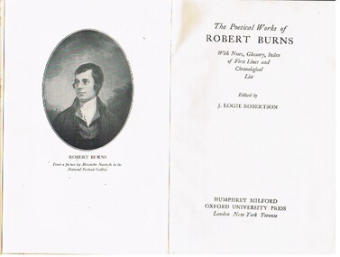
Book - ALEC H CHISHOLM COLLECTION: BOOK ''THE POETICAL WORKS OF ROBERT BURNS''
Book. ALEC H CHISHOLM COLLECTION. 635 page hardback collection of verse by Robert Burns. Edited by J. Logie Robertson with notes, glossary and index to first lines. Image of Robert Burns opposite title page. Published in 1942 by Oxford University Press. Printed by Latimer Trend & Co., Plymouth. Catalogue sticker '2041 BUR' on spine. Two newspaper articles marking the birthday of Robert Burns (25 Jan. 1759) inside front cover. The Age 27/01/1951 and the Sydney Morning Herald 23/01/1971.Robert Burnsbooks, collections, poetry, alec h chisholm collection, robert burns, poetry -
 Bendigo Historical Society Inc.
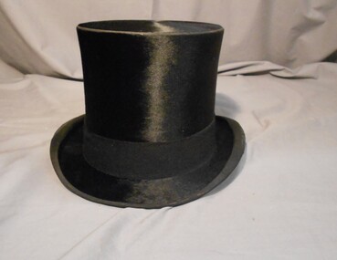
Clothing - MAN'S SILK TOP HAT, Late 1800's-early 1900's
Fine smooth black silk. Brim bound with black fabric. Side edges of brim rolled inwards. A 4cm wide felt band runs around the base of the crown. Underside of brim lined with black fabric. A 6.5cm wide band of cream leather lines the crown. A fine one cm wide silk ribbon bow finishes the seam of the leather. Upper part of crown is lined with cream silk. Marking on leather band ;W2637, also written in biro RHSV. In hat box 11400.835, packed in Clothing Box 158.HILHOLISE & Co, Hat and Cap Makers, 11,New Bond Street, London.costume, male, man's silk top hat -
 Bendigo Historical Society Inc.
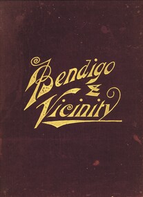
Book - (Copy) BENDIGO & VICINITY, c1895
Bendigo and Vicinity: A comprehensive history of her past, and a resume of her resources: Together with the biographies of her representative pioneers, public, commercial, and professional men. (1895). Compiled by W. B. Kimberly. Publisher: F W Niven & Co Printers and Publishers, Melbourne and Ballarat. 273 pages. Illustrations: Photographs, illustrations, listing of dividends, copies of collages. Markings: Royal Historical Society of Victoria – Bendigo Branch In front and back. Inscription reads: Donated by Hilda Meurer. To the Historical Society, daughter of pioriners Mr & Mrs A Meurer. July 6th 1954W B Kimberlybook, bendigo, bendigo history & its people, bendigo history, family tree, councilor, gold, biographies, travel to australia -
 Bendigo Historical Society Inc.
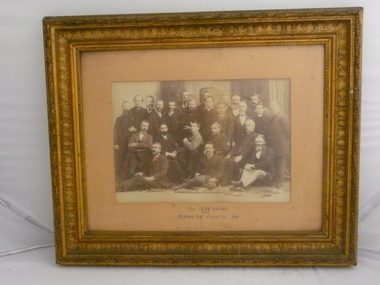
Photograph - IRISH ENVOYS AND SANDHURST COMMITTEE 1889, 1889
Group of 24 men in dark suits, some sitting and some standing. On front -- The Irish Envoys and Sandhurst Committee. 1889. Markings on back: Back row - 3rd from left - Colgan. Father - 3rd from left - back row. Gilt edging on frame. Northcott's Band preceded the procession from the railway station following the Irish Envoys arrival. Hibernian Society members present. See Bendigo Advertiser article 8th May, 1889, page 3: https://trove.nla.gov.au/newspaper/article/88586344?searchTerm=irish%20envoysperson, group, sandhurst committee -
 Bendigo Historical Society Inc.
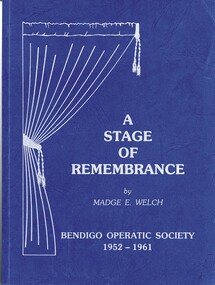
Book - A STAGE OF REMEMBRANCE, 1988
A Stage of Remembrance. History of Bendigo Operatic Society, 1952 - 1961.Copy 5240 is signed by the author.contains a three (3) page letter from the author. A Stage of Remembrance : A "Capital" view of the The Bendigo Operatic Society from its inception in 1952. (1988) Madge E. Welch Printed by Cambridge Press, Bendigo ISBN 0 7316 4708 4 Includes b/w photographs. Blue card cover with tag line "History of Bendigo Operatic Society, 1952 - 1961" Markings – Bendigo Historical Society Inc. stamp front and back.Madge E. Welchbendigo, history, bendigo operatic society, history of the arts in bendigo. -
 Bendigo Historical Society Inc.
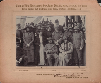
Photograph - VISIT OF HIS EXCELLENCY SIR JOHN FULLER TO THE CENTRAL RED, WHITE AND BLUE MINE
Black and white photograph recording the visit of his Excellency Sir John Fuller, Bart., K.C.M.G. and party to the Central Red, White and Blue Mine, Bendigo 10th June, 1911. There are two X beneath two people marking the Mayor and Mayoress of Bendigo William Henry Wilkie and Mary (nee Clough). This was in their first term as Mayor and Mayoress, their second term was in 1914/15. With the compliments of Peter McBride Minister of Mines and Forests. The photo was taken by W. H. Robinson, Bendigo. Donated by A. Wilkie, grandson of former Mayor Bendigo, William Henry Wilkie.business, mining, central red, white and blue mine -
 Bendigo Historical Society Inc.
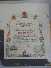
Document - JACOB COHN CERTIFICATE, 1908
Handwritten and drawn certificate on card to Jacob Cohn and wife from members of the Danish Association. Written in Danish language in black and red bordered by shields with depictions of a horse, castle, and dates, and showing illustrations of Denmark and snow covered trees, a viking ship and topped with a crest between two men. Markings - J. W. Swanekiaer Partial translation of certificate - To Jacob Cohn & wife. Members of the Danish Association 'Dannebrog' hereby authorise to convey them and their wife warm Lykonskinger the occasion of their Guldbryllup. With the warmest onsker for the future and thanks for their great interest in the Danish welfare in Australia.person, individual, jacob cohn -
 Bendigo Historical Society Inc.
Document - MCCOLL, RANKIN AND STANISTREET COLLECTION: DEBORAH EXTENDED GOLD MINES NL, SOLOMONS PTY LTD AND OTHER, OPTION AGREEM, 1970
McColl Rankin & Stanistreet, Deborah Extended Gold Mines NL, Solomon's PTY LTD & Others, Fraenkel & Kiven, Solicitors. Option Agreement 20/11/1970. Claims Nos. 2700, 2701 & 2702, holder of share Harold Boucher. Markings/Inscriptions of: Solomon's PTY LTD, Director ?? Secretary R A Jobson. Fearnly Investments PTY LTD, ? ? Director, ?? Secretary. Signed Sealed and Delivered by the said Douglas Graeme Williams, D Graeme Williams, ? ? ,Deborah extended Gold Mining Co NL C MacNeice Director, ? ? ? Director.organization, business, mine, mccoll rankin & stanistreet, deborah extended gold mines nl solomon's pty ltd fraenkel & kiven 1970 mineral claims 2700 2701 2702 -
 Bendigo Historical Society Inc.
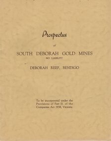
Document - MCCOLL, RANKIN AND STANISTREET COLLECTION: PROSPECTUS OF SOUTH DEBORAH GOLD MINES NL, 1939
McColl Rankin & Stanistreet, Prospectus of South Deborah Gold Mines NL. 5 Copies. A/ Complete with map, application for Shares still intact. Excellent condition. B/ Complete, application detached, excellent condition. C/ Complete, application form detached, excellent condition. D/No map, Application Form still intact. Has been folded down middle. Good condition. E/No map or Application Form, Good condition. Markings/inscriptions: Prospectus of South Deborah Gold Mines No Liability, Deborah Reef, Bendigo. 8 pages.organization, mining, south deborah gold mines nl, mccoll rankin & stanistreet, prospectus of south deborah gold mines nl -
 Bendigo Historical Society Inc.
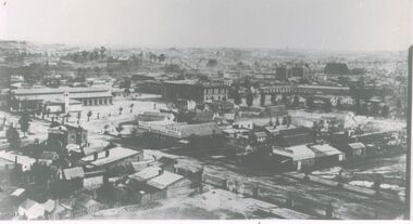
Photograph - SANDHURST - FROM ST PAUL'S TOWER, 1876
Black and White Photo, Taken from ST Paul's Tower 1876, shows the original Town Hall Building in the centre of the photograph, The Benevolent Asylum can be seen in the background of the photograph just above the old town hall, also shown in the photo is Cumberland Family Hotel, King's Produce, Mick's Carriage Company, Markings on rear of photo read 'from ST Paul's Tower looking towards Town Hall 1876'. Centre left side shows the market hall designed by Vahland, foreground of market is a Fire Station with small tower.buildings, commercial, town hall, st paul's tower, bendigo aenevolent home, anne caudle centre, cumberland family hotel, kings produce, micks carriage company -
 Glenelg Shire Council Cultural Collection
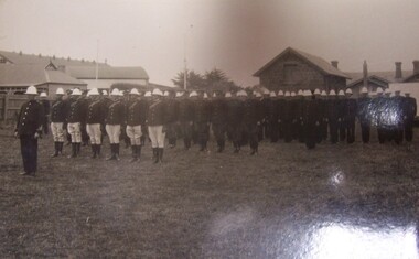
Postcard - Postcard - Police escort for Duke of Gloucester, Portland, 1934
HRH Prince Henry Duke of Gloucester came to Australia in late 1934, and to Victoria in time for the Centenary Celebrations (of pastoral settlement of the Port Phillip District, beginning with the Hentys settlement at Portland Bay on 19 November 1834). From Trove - 20 November 1934 Historic Portland was the scene yesterday of unprecedented celebrations when the Duke of Gloucester arrived from Tasmania to join in festivities marking the beginning of Victoria's second century. A great crowd estimated at more than 60,000 people watched the re-enactment of the landing of Edward Henty, Victoria's first permanent settler, on November 19, 1834.Black and white photograph rows of men in formal dress with white jodhpurs, dark coats and white hats. Five rows in all, with one man at the front. Buildings in the background. Police escort for Duke of Gloucester, Portland, 1934Front: (no inscriptions) Back: Police escort for Duke of Gloucester Portland 1934royal visit, 1934, duke of gloucester -
 The Beechworth Burke Museum
Photograph
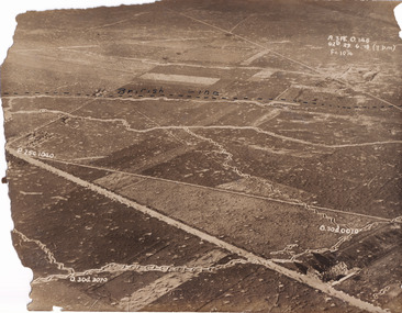
Taken some time between 1914-18, the photograph depicts an aerial view of trenches in France. The image mostly shows rural landscape, although there is a house in the bottom right corner. A dotted line has been drawn across the photograph, marking the section of trenches that belonged to British forces during World War I. It is believed that the line marking on this record denotes a section of the Western Front. The Western Front was the main theatre of war during World War I. Following the outbreak of war in August 1914, the German Army opened the Western Front by invading Luxembourg and Belgium, then gaining military control of important industrial regions in France. The German advance was halted with the Battle of the Marne. Following the Race to the Sea, both the French-British and German armies dug in along a meandering line of fortified trenches, stretching from the North Sea to the Swiss frontier with France. Between 1915 and 1917 there were several offensives along the Western Front. The attacks employed massive artillery bombardments and massed infantry advances. Entrenchments, machine gun emplacements, barbed wire and artillery repeatedly inflicted severe casualties during attacks and counter-attacks and no significant advances were made. Among the most notable of these offensives were the Battle of Verdun (1916), the Battle of the Somme (1916), and the Battle of Passchendaele (1917).The record is historically significant due to its connection to World War I. This conflict is integral to Australian culture as it was the single greatest loss of life and the greatest repatriation of casualties in the country's history. Australia’s involvement in the First World War began when the Australian government established the Australian Imperial Force (AIF) in August 1914. Immediately, men were recruited to serve the British Empire in the Middle East and on the Western Front. The record has strong research potential. This is due to the ongoing public and scholarly interest in war, history, and especially the ANZAC legend, which is commemorated annually on 25 April, known as ANZAC Day.Sepia rectangular photograph printed on matte photographic paper.Obverse: A.3FE.O.146 / G2R 29 . 6 . 18 (Y p.m) / F= 10 1/4 / British Line / ------------------------------------------ / P. 250 1040 / 0. 30d. 0010 / 0. 30d. 3070 /military album, military, war, wwi, world war i, france, great britain, trenches, village, rural, western front -
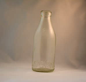 Kiewa Valley Historical Society
Bottle Milk, early 1900's
This glass milk bottle was manufactured and used mid to late 1900's (1834 Victorian dairy industry was founded) up to the time that a cheaper container was invented(plastic bottles and polyethylene plastic lined cardboard cartons) and produced. In 1909 the supply of pure bottled milk was required for babies to overcome infant mortality due to unhygienic milk sources (unclean containers and unpasteurized milk). Due to the volume of milk being processed and hand milking could not keep up with demand, dairy farms introduced milking machines in the late 1930's. The great increases in dairy herds from the average of 18 cows per heard in 1950's to 142 cows per herd in 1996 required milk tankers to pick up the regions milk supply. This bottle was so constructed to be easily moved within the milk processing plants from the delivery vats/holding tanks to the final corking/sealing of the bottles for eventual distribution. From 1958 the milk bottle slowly became phased out of production. At this point in time Melbourne was drawing 160,000 bottles per week from the two major glass bottle works companies, e.g. Melbourne Glass Bottle Works Co. Victoria was the major state supplier of cows milk in the history of Australian milk production from the early 1800's. The Kiewa Valley and its region was a major contributor to meet that demand. Each bottle was "branded" during manufacturing to show the contents (pasteurized milk) and where it originated from (region and supplier). This method of recycling the bottles back to specific dairy farms was a good control method but an uneconomical "on cost" which was replaced by the "throw away" less costly plastic and cardboard containers. Kiewa Valley dairy herds had marked bottles bearing "90/9", "6/18", "6/33", "6/35" and "6/36" This heavy gauged glass milk bottle has a rim and a distinctive head at the top. This head has been manufactured to facilitate the movement of the bottled along the milk production line. The method of pouring milk into the bottle has been part of the "production line". This bottle has a one pint capacity and is made from "clear" glass. There are other milk bottles that have a "green" tint in them.Around the bottom side of the bottle and blown into the glass "ONE PINT" and on the opposite side "MILK". Below these markings is "This BOTTLE BELONGS TO MILK BOTTLES RECOVERY LTD" below this "AND CANNOT BE USED WITHOUT WRITTEN PERMISSION. On the base of the bottle is molded a big "M". An identification mark of "90" over "9" is beneath the "M". glass bottles, commercial milk containers, domestic milk bottles, pasteurized milk bottles, milk, dairy, farms, kiewa valley -
 Caulfield RSL Sub Branch
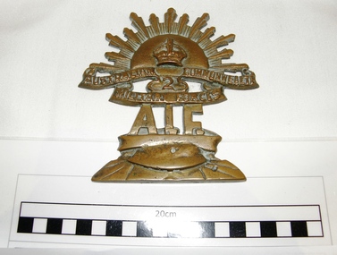
2nd AIF brass plaque, unknown
Appears to be a 2nd AIF plaque which may have belonged to SGT Robert Henry Baxter.An item which refers to the 2nd Australian imperial force and WW2.Solid Brass plaque from mold, World War 2 era Plaque comprised of 2 areas(not parts) . Upper ,rising sun emblem marked "AUSTRALIAN COMMONWEALTH MILITARY FORCES" with the number 2 under the crown. Lower, with lettering "A.I.F" on top of a tin helmet. Back of plaque has no markings, is uneven from molding process and has not been filed to a smooth finish. rising sun badge, 2nd aif -
 Mont De Lancey
Book, Ruth M. Arthur et al, The Crooked Brownie, c.1944
A school reader for children ages 8 to 9 years. The brownie has many adventures.A small green format school reader No 353 from the Whitcombe's Story Books series : The Crooked Brownie for Ages 8 to 9 Years. The title is printed in red lettering on the front cover with the series above and age group beneath in black lettering. Inside a black lined rectangular shape is a lined drawing of a frog talking to the brownie - on a sign is written 'Samuel Frog Furniture Maker'. 1/- for the cost is in the right hand bottom corner. Inside the front and back covers are additional series Whitcombe & Tombs Ltd publishes. The story has 10 chapters with black and white illustrations. Pp62.non-fictionA school reader for children ages 8 to 9 years. The brownie has many adventures.school reader, australian schools, school equipment -
 Kiewa Valley Historical Society
Photograph - Folder of Photographs – Photocopied set of black and white photographs (pages 39 - 48) from the display folder put together by KVHS to document life on the Kiewa Valley Hydro-electric Scheme
Although the Kiewa Hydro-Electric Scheme was first proposed in 1911, construction did not commence until 1938. As part of the push to cut electricity costs and diversify supply, the Victorian Government (circa 1930) initiated the conversion from primarily brown coal supply to hydro – electricity. Field investigations during the 1940’s resulted in a new proposal for a scheme that had more than double the capacity of the 1938 scheme. The Kiewa Hydroelectric Scheme became the largest scheme of its kind in the State Of Victoria and the second largest scheme in Australia. The number of personnel involved in the planning and construction of the scheme increased dramatically. During the late 1940’s, most activity centered around the construction of the West Kiewa Power Station, Rocky Valley Reservoir, McKay Creek Power Station and the Bogong Creek Aqueduct.A common thread across all the larger hydro scheme constructions was the need for workers, both qualified and unqualified who came from around the world seeking a new life for themselves and their families. New accommodation and facilities were required for the army of workers engaged in construction in often remote and wild areas. The SEC had a high demand for timber, and set up the first of a number of sawmills at Bogong Creek in 1939 and set up the first hardwood logging in the headwaters of the Kiewa River. These new ‘towns’ such as Mt Beauty and Bogong, survived, serving the needs of operational personnel and their families, and expanding with growth of new industries. Mount Beauty, and to a lesser extent Bogong, are among these places. Large A3 size spiral bound display folder containing photocopied black and white photographs of various aspects of the early days of the Kiewa Valley Hydro-electric scheme including equipment, various work sites and photographs of workers and their families. 1-Breakdown in Circuit Breaker (Isolating Contacts) 2-Big Hill Bench- Site of No 5 Devlopment 3-No 1 Power Station 4-No 1 Pipeline, Anchor No 8 5-Push Dozing-RD8 Tractor 6- Tractor and driver at work 7- Workmen in unnamed tunnel 8- Front page of Journal of SECV Vol 15. Photograph of No 1 pipeline viewed from McKay Portal 9-Rocky Valley Dam Core Wall 10-Workmen working inside tunnel loading rocks into a rail truck. 1-Breakdown in (generator) Circuit Breaker (Isolating Contacts) Handwritten underneath (This is not a picture of any part of a generator. It is a circuit breaker Signed Ron White Ron was the Principal Hydro Engineer of the SEC Kiewa Scheme Page number 39 2-Big Hill Bench – Site of No. 5 Development (abandoned) Page number 40 3-No 1 Power Station Page number 41 4-No. 1 Pipeline, Anchor No. 8 Page number 42 5-Push Dozing – RD8 Tractor, 12 cubic yard Carryall and FD Cletrac Tractor Page number 43 6-No marking Page number 44 7-No marking Page number 45 8-Journal of State Electricity Commission of Victoria SEC Vol 15 No… April-May, 19… No 1 Pipeline-A view from McKay Portal G Hempenstall and D Sutton stiffening pipe section for transport during construction (….indicates missing text) Page Number 46 9-Rocky Valley Dam Core Wall Page number 47 10-No markings Page number 48 secv; kiewa hydro electric scheme; construction area; power stations; reservoirs; aqueduct; mt beauty; bogong -
 Montmorency/Eltham RSL Sub Branch
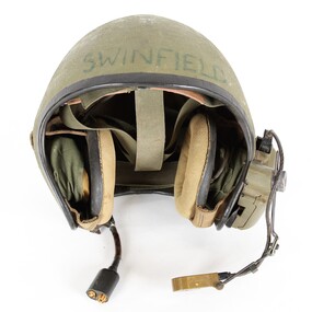
Headwear - Helmet, vehicle, intercom
Worn by Swinfield in IraqWorn by Swinfield in IraqBlack edge trimmed green fibreglass Army vehicle intercom helmet. Adjustable head straps inside helmet, Adjustment strap for right earphone located on ouside of right ear. Earphones mounted inside helmet at each ear side. Voice microphone located at mounting on outside of the left ear connected by black cable to mounting on outside of left ear. Cable connection with clip for helemt connection to vehicle located at outside of left ear. Switch located on mounting on outside of left ear. Plastic mounting box located on ouside of the left ear. Brown leather sweat band on helmet straps on inside front of the helmet. Male and female connections on end of vehicle connection point.Swinfield marked on outside front of helmet. 34B marked on outside of helmet at rear. Roamwell Corp. with number SA-1552,6 marked on plastic mounting on outside of right ear. Front and back markings on microphone. M138/6 marked on back of microphone. ID label on connection point end of vehicle connection cable. -
 Geoffrey Kaye Museum of Anaesthetic History
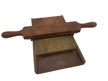
Press, Pill, S Mawson & Thompson
Before mechanisation, pills were rolled by hand using equipment such as this pill press. Powders ingredients were blended together to form a resin, rolled and laid across the width of the platform. The paddle was then used to push the "sausage" shape through the grooves, creating a small, consistently sized and shaped, pill. The pill was then allowed to dry for later sale. This pill press is of uncertain origins but is representative of the type of equipment used to create pills in the 19th Century. It has the capacity to make 24 pills at once, and markings on the metal plate indicate each pill would have been the equivalent of "5 grains" (approx 0.3 grams).Rectangular wooden platform with a metal (brass) plate divided into 24 (twenty-four) grooves with a catchment area. The wooden paddle has two handles, one on each end, with a matching metal plate and grooves, as well as metal (brass) guide bars to help the paddle align with the platform.Handwritten on base of platform in black ink over white background: C11087 Handwritten on inside of guide bar on paddle in black ink over white background: C11087 Manufacturer's detail stamped into metal groove on platform: S. MAW SON / & / THOMPSON / LONDONpill press, pharmaceuticals, apothecary, pharmacy -
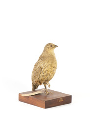 The Beechworth Burke Museum
Animal specimen - Brown Quail, Trustees of the Australian Museum, 1860-80
This specimen is part of a collection of almost 200 animal specimens that were originally acquired as skins from various institutions across Australia, including the Australian Museum in Sydney and the National Museum of Victoria (known as Museums Victoria since 1983), as well as individuals such as amateur anthropologist Reynell Eveleigh Johns between 1860-1880. These skins were then mounted by members of the Burke Museum Committee and put-on display in the formal space of the Museum’s original exhibition hall where they continue to be on display. This display of taxidermy mounts initially served to instruct visitors to the Burke Museum of the natural world around them, today it serves as an insight into the collecting habits of the 19th century. Like many species of quail, the Brown Quail is often difficult to see, as it inhabits rank, overgrown grassy areas, often in damp, low-lying patches beside wetlands. They are difficult to flush from this cover, preferring to squat among the grass or run quickly off through the vegetation rather than fly off. As is the case with many species that inhabit dense habitats, the Brown Quail may be heard more often than it is seen, with its characteristically mournful two-note call whistle often heard at dawn and dusk. The Brown Quail is found across northern and eastern Australia, from the Kimberley region in Western Australia to Victoria and Tasmania, as well as in south-western Australia. It is also found in Papua New Guinea and Indonesia, and has been introduced to New Zealand. The Brown Quail feeds in the early morning or evening, on the ground, mainly on seeds and green shoots, but also on insects. In some area, quails will readily cross roads and may be seen feeding along roadsides.This specimen is part of a significant and rare taxidermy mount collection in the Burke Museum. This collection is scientifically and culturally important for reminding us of how science continues to shape our understanding of the modern world. They demonstrate a capacity to hold evidence of how Australia’s fauna history existed in the past and are potentially important for future environmental research. This collection continues to be on display in the Museum and has become a key part to interpreting the collecting habits of the 19th century. The Brown Quail is a small, plump ground-dwelling bird. It is variable in colour, ranging from red brown to grey brown with fine white streaks and black barring above, and chestnut brown below. The eye is red to yellow, the bill black and the legs and feet orange-yellow. In Tasmania, this species is called the Swamp Quail and tends to be larger and darker than mainland birds, with a pale yellow eye. Female Brown Quails are larger and may be more heavily marked with black and paler below than males. Young birds are like adult females, with less distinct markings and a dark brown eye.Label: 33. / Swamp Quail / See Catalogue, page 30 / Mount: 09/taxidermy, quail, brown quail, taxidermy bird, burke museum taxidermy -
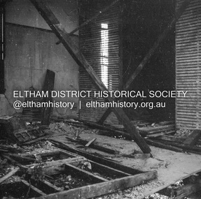
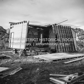 Eltham District Historical Society Inc
Negative - Photograph, J.A. McDonald, Inspection of storm damaged Abraham house at Kangaroo Ground, c. May 1962
Showing the effect of a wind storm that destroyed the house circa May 1962.. The Abraham family owned land near the Aqueduct and east of Nicholas Lane at Kangaroo Ground (based on photos, at or near 40 Nicholas Lane).Record of various Shire of Eltham infrastructure works undertaken during the period of 1952-1962 involving bridge and road reconstruction projects, sometimes with Eltham Shire Council Project Reference numbers quoted. It was during this period that a number of significant improvements were made to roads and new bridges constructed within the shire that remain in place as of present day (2022). In many situations, the photos provide a tangible visible record of infrastructure that existed throughout the early days of the Shire. The album was put together by or under the direction of the Shire Engineer, J.A. McDonald.1962-05, abraham house, kangaroo ground, nicholas lane, property damage, storm damage -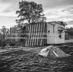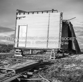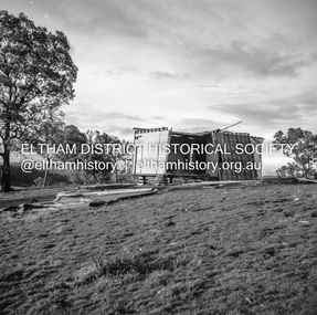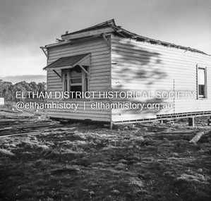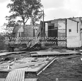
 Eltham District Historical Society Inc
Negative - Photograph, J.A. McDonald, Inspection of storm damaged Abraham house at Kangaroo Ground, c. May 1962
Showing the effect of a wind storm that destroyed the house circa May 1962.. The Abraham family owned land near the Aqueduct and east of Nicholas Lane at Kangaroo Ground (based on photos, at or near 40 Nicholas Lane).Record of various Shire of Eltham infrastructure works undertaken during the period of 1952-1962 involving bridge and road reconstruction projects, sometimes with Eltham Shire Council Project Reference numbers quoted. It was during this period that a number of significant improvements were made to roads and new bridges constructed within the shire that remain in place as of present day (2022). In many situations, the photos provide a tangible visible record of infrastructure that existed throughout the early days of the Shire. The album was put together by or under the direction of the Shire Engineer, J.A. McDonald.1962-05, abraham house, kangaroo ground, nicholas lane, property damage, storm damage, building surveyor, george e. newton -
 Eltham District Historical Society Inc
Negative - Photograph, J.A. McDonald, Inspection of storm damaged Abraham house at Kangaroo Ground, c. May 1962
Showing the effect of a wind storm that destroyed the house circa May 1962.. The Abraham family owned land near the Aqueduct and east of Nicholas Lane at Kangaroo Ground (based on photos, at or near 40 Nicholas Lane).Record of various Shire of Eltham infrastructure works undertaken during the period of 1952-1962 involving bridge and road reconstruction projects, sometimes with Eltham Shire Council Project Reference numbers quoted. It was during this period that a number of significant improvements were made to roads and new bridges constructed within the shire that remain in place as of present day (2022). In many situations, the photos provide a tangible visible record of infrastructure that existed throughout the early days of the Shire. The album was put together by or under the direction of the Shire Engineer, J.A. McDonald.1962-05, abraham house, kangaroo ground, nicholas lane, property damage, storm damage -
 Eltham District Historical Society Inc
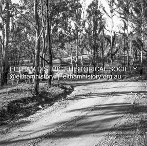
Negative - Photograph, J.A. McDonald, Clintons Road, Christmas Hills, 2 July 1962
Looking southwards Temporary bridge on RHS 2 July 1962 The bridge was destroyed by bushfires 15-16 January 1962Record of various Shire of Eltham infrastructure works undertaken during the period of 1952-1962 involving bridge and road reconstruction projects, sometimes with Eltham Shire Council Project Reference numbers quoted. It was during this period that a number of significant improvements were made to roads and new bridges constructed within the shire that remain in place as of present day (2022). In many situations, the photos provide a tangible visible record of infrastructure that existed throughout the early days of the Shire. The album was put together by or under the direction of the Shire Engineer, J.A. McDonald.1962-07-02, bridge construction, christmas hills, clintons road, infrastructure, shire of eltham, victorian bushfires - 1962, bush fires -
 Eltham District Historical Society Inc
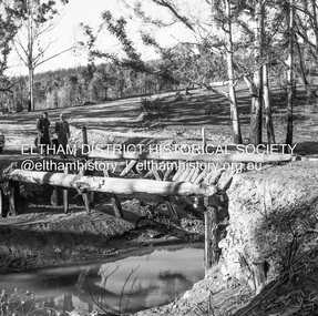
Negative - Photograph, J.A. McDonald, Clintons Road, Christmas Hills, 2 July 1962
Burned bridge Temporary bridge on RHS 2 July 1962 The bridge was destroyed by bushfires 15-16 January 1962Record of various Shire of Eltham infrastructure works undertaken during the period of 1952-1962 involving bridge and road reconstruction projects, sometimes with Eltham Shire Council Project Reference numbers quoted. It was during this period that a number of significant improvements were made to roads and new bridges constructed within the shire that remain in place as of present day (2022). In many situations, the photos provide a tangible visible record of infrastructure that existed throughout the early days of the Shire. The album was put together by or under the direction of the Shire Engineer, J.A. McDonald.1962-07-02, bridge construction, christmas hills, clintons road, infrastructure, shire of eltham, victorian bushfires - 1962, bush fires -
 Eltham District Historical Society Inc
Negative - Photograph, J.A. McDonald, One Tree Hill Road Bridge, Christmas Hills, 2 July 1962
One Tree Hill Road Looking south 2/7/62 The bridge was destroyed by bushfires 15-16 January 1962. A temporary bridge was set up to the east sideRecord of various Shire of Eltham infrastructure works undertaken during the period of 1952-1962 involving bridge and road reconstruction projects, sometimes with Eltham Shire Council Project Reference numbers quoted. It was during this period that a number of significant improvements were made to roads and new bridges constructed within the shire that remain in place as of present day (2022). In many situations, the photos provide a tangible visible record of infrastructure that existed throughout the early days of the Shire. The album was put together by or under the direction of the Shire Engineer, J.A. McDonald.1962-07-02, bridge construction, christmas hills, infrastructure, shire of eltham, victorian bushfires - 1962, bush fires, one tree hill road, property damage