Showing 25660 items
matching plenty-township-estate
-
 Southern Sherbrooke Historical Society Inc.
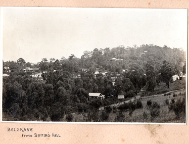
Photograph, Belgrave from Biffin's Hill
Photo of Belgrave township from Biffin's Hill (present-day site of Mater Christi School). Road running across front of photo is now Belgrave-Gembrook Rd. There is a sign on the side of the road advertising Biffin Hill Estate for sale. Belgrave main street is visible in background. c. 1920s -
 Whitehorse Historical Society Inc.
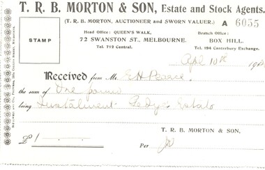
Legal record - Ephemera, E. H. Pearce, 1920
A receipt for one pound.A receipt for one pound as a deposit on land at the Gedye's Estate issued by T. R. B. Morton & Son to E. H. Pearce on 4 Apr 1920.A receipt for one pound. pearce, edward h., gedye's estate, morton, thomas richards burrowes & son -
 Warrnambool and District Historical Society Inc.
Document (item) - Allansford land purchase document, Land purchase document, 1864
Thiss paper contains details of the purchase of Lot 11 in the Township of Allansford in 1864. The purchaser, Isabella McQueen, was born in Scotland in 1814, married Alexander McQueen in 1850 and with her family migrated to Australia in 1854. After her husband's death in 1860 Isabella purchased the land in Frank Street, Allansford in 1864 and lived in a house there with family members until her death in 1895. She had purchased the land, via an agent, from John Allan who with his brothers were the pioneer European settlers in the Allansford area. John Allan had created the township of Allansford in the mid 1850s by sub-dividing the land he owned there. John Allan moved to the Gippsland area late in 1864. This scrap of paper is most significant as it is an original record of an early transaction in the history of Allansford, a town now part of Warrnambool City.Mrs isabella McQueen Bot. of Robert Gregory As agent for J M Allan Esq. Lot no. 11 as marked and described on the Plan of Subdivision of the Township of Allansford. For which I have received the um of five pounds Stg. being the purchase money of same. Robert Gregory 21st October 1864allansford history, john allan, isabella mcqueen -
 Lakes Entrance Regional Historical Society (operating as Lakes Entrance History Centre & Museum)
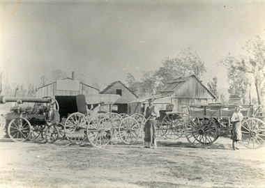
Photograph, P Hancock, 1900 c
Henry Froud's Blacksmith Coach Building and Wheelwright's business set up at original surveyed site west of present township, nearer to cemetery turnoff,. Business first moved to corner of Princes Highway and Bruthen Road, (now site of Black Stump Store), then moved to premises built by Harry Froud on south side of highway, corner of Punt Road, (present site of BP Garage).Black and white photograph of Harry Frouds first coach factory west of present township, showing three men in front of four wheeled vehicles including a steam engine. Three workshops in background, two having bark roofs, man in centre identified as Harry Froud, William Henry. Johnsonville Victoria.retail trade, transport -
Whitehorse Historical Society Inc.
Document, F. S. Baker/ Yarra Hill country map, 1950s
Advertising leaflet for F. S. Baker, Mt. Pleasant Road Nunawading,Advertising leaflet for F. S. Baker, Mt. Pleasant Road Nunawading, Real Estate Agent c. 1950s, backed by Broadbent's Map no. 280, Yarra Hill CountryAdvertising leaflet for F. S. Baker, Mt. Pleasant Road Nunawading, broadbents, baker, f. s., mount pleasant road, nunawading, no. 20 -
 Greensborough Historical Society
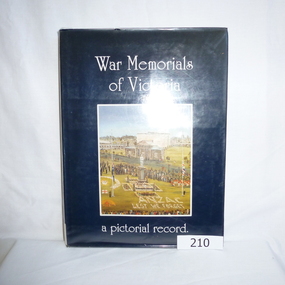
Book, War Memorials of Victoria: a pictorial record, 1994_
A photographic record of War memorials throughout Victoria. Includes 30 oil paintings of War memorials by Dacre Smith. Researched by Harold Bradley [et al]; compiled and designed by Max Parsons and Syd Trigellis-Smith.A record of over 1100 war memorials in Victoria; some photographs forwarded by RSL sub-branches.240 pages, illustrations (some colour).Stamps: Yarra Plenty Regional Library Service. Withdrawn [from collection]war memorials victoria, returned services league, syd trigellis smith, max parsons, dacre smith, harold bradley -
 Whittlesea Historical Society Inc.
Photograph, Evan Meades, St. Joseph's Catholic Church, Mernda, Mar 1989
One of a series of photographs taken in 1988-1989 around the Shire of Whittlesea by Evan Meades.Print copy of a photograph"St. Joseph's Catholic Church, Plenty Road, Mernda, March 1989"evan meades collection, st. joseph's catholic church, mernda, bluestone church, plenty road mernda -
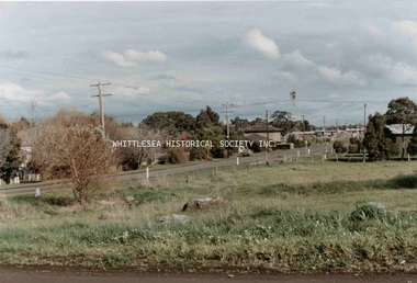 Whittlesea Historical Society Inc.
Photograph, Kevin Doyle, South Morang, 1984
One of a series of photographs taken and developed during 1967-2013 by the late Kevin Doyle for Media Studies Year 12 at Parade College Bundoora (1984) and donated to the Society by his mother Maureen Doyle.PhotographLooking south on Old Plenty Road, south of Williamson's Road, 1984.kevin doyle collection, south morang, old plenty road south morang -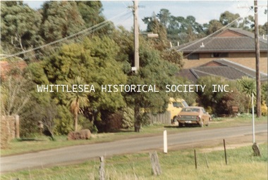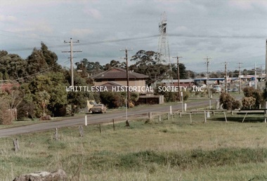
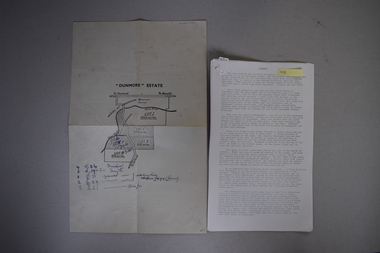 Warrnambool and District Historical Society Inc.
Map and Article, Dunmore, 1 1954 .2 1970
Both these items deal with the property of Dunmore, in the Macarthur/Hawkesdale/ Woolsthorpe area of Western Victoria. The first item is a sheet of paper with a map and details of the sale of portion of Dunmore in 1954. This is an original document. The second item is a history written by Stan Baulch of the property Dunmore from its establishment up to 1970. Dunmore was first established by Charles Hamilton MacKnight and two partners in 1842 and it was purchased by Samuel Baulch in 1893. After Samuel Baulch’s death the property was bequeathed to his three sons. One son, Stanley Baulch (1897-1980) took over the eastern portion which he named Rose Park. Stan Baulch was a member of the Warrnambool and District Historical Society and wrote several articles on aspects of his life and work, including this valuable article on the history of Dunmore. These items are of significance as they concern the estate of Dunmore in Western Victoria, an early and important property which is still farming land today under various owners. .1 This is a sheet of paper containing a map of the Dunmore property on one side and details of the sale of portion of Dunmore on the other side. The map has been annotated in handwritten black ink. The page has been folded twice. .2 This is an article typed on 12 foolscap pages. The typing is somewhat faint in places. ‘Dunmore’ Estate Dunmore baulch family, western district, victoria, dunmore estate, macarthur/hawkesdale, history of warrnambool -
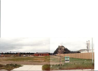 Hume City Civic Collection
Photograph, early 1990s
The series of 5 photographs feature different views of the Woodlands housing development which opened up land bounded by Gap and Anderson Roads, Cornish Street and Elizabeth Drive in the early 1990s. It was a large housing development built close to Sunbury township.A view of the northern boundary of the Woodlands housing development in Anderson Road. A paling fence divides the estate from the 'Malley' factory, now 'Storage King' which is on the corner of Cornish Street and Anderson Road. A 'For Sale' sign is in the foreground and a partly built house is in the middle distance.housing developments, anderson road, george evans collection -
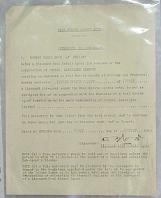 National Wool Museum
Letter
Authority from Rupert Vance Moon, licenced Real Estate Agent of Dennys Lascelles, for Norman George Cooper of Cobden to act as his sub-agent.Authority from Rupert Vance Moon, licenced Real Estate Agent of Dennys Lascelles, for Norman George Cooper of Cobden to act as his sub-agent.wool sales - auction system, dennys, lascelles limited, moon, mr rupert vance - dennys lascelles limited wilson, mr norman george -
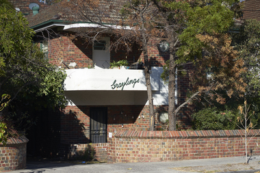 Mission to Seafarers Victoria
Photograph - Digital Image, series, 05/04/2019
Graylings estate was purchased by Frederick Race Godfrey around 1872 on return of a family trip to England. Reverend Gurney Goldsmith met Ethel Godfrey here while he was invited for lunch and rose her interest in the cause of the sailors. The Godfreys organised two picnics for sailors on their property, one in 1905 and one in 1910. The estate was auctioned and subdivided in 1910 after Fredrick's death. But early the same year he had a second house built on the estate. A brick building that may be what is now the Graylings apartments. According to electoral rolls, Ethel Godfrey and her sisters Frederica and Winifred lived at 95 Alma Road. Ferderica Godfrey, one of the earliest female student of Burnley Horticultural College (1899 or1900-1903) is thought to have created the landscaping of the Graylings gardens. Street signs in St Kilda East depicting the area surrounding the former Grayling estate owned by Frederick Race Godfrey until his death in 1910.graylings, frederick race godfrey (1828-1910), ethel augusta godfrey, alma road, st kilda east, burnley horticultural colleg, frederica godfrey, rica godfrey, rita godfrey -
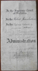 Warrnambool and District Historical Society Inc.
Document - James Jones Letters of Administration 1910, 1910
Tait collection: item 29 of 62 This document contains information on the Will and Letters of Administration of James Jones, a gardener from Warrnambool. The document indicates that he died intestate in August 1896 at the age of 57 but details of a will are included in the document. The fact that this document was drawn up 14 years after his death indicates that there was a problem with the will. James Jones left real estate to the value of £80 and personal estate to the value of £10. The sole beneficiary was his widow, Mary Ann Jones. No other information has been found on James Jones. No Warrnambool lawyer is mentioned in this document but it was located at the former legal premises in Kepler Street of Mackay Taylor and passed on to the Warrnambool and District Historical Society in 2014. It is presumed that it had been passed down to successive lawyers occupying the same building since 1910. This document is of interest because it contains information on the Will and Letters of Administration of a Warrnambool resident, James Jones. It will be useful for research.This is a cream-coloured piece of parchment paper (1910) folded in two with handwritten material on three sides. The first page has black printed material in script with the information filled in in black ink. It contains the information on the Will and Letters of Administration of James Jones, a gardener from Warrnambool. The paper is ruled on one side with black lines. The seal of the Supreme Court of Victoria is attached with green ribbon. One page is very stained. In the Supreme Court of Victoria; In the Probate Jurisdiction; In the Will and Estate of James Jones late of Warrnambool in Victoria Gardener deceasedjames jones, warrnambool, tait collection -
 Bacchus Marsh & District Historical Society
Map, Plan of the property of Messers Aitkins and Clarke to be sold at the Mansion, Bacchus Marsh 19th April 1856
This plan of land allotments for sale indicates the property once owned by the Bacchus family in and around the township area of Bacchus Marsh. The Bacchus family sold their property in Bacchus Marsh to John Aitkins and Robert Nalder Clarke in March 1851. Aitkins and Clarke kept the property for a number of years until April 1856 when these allotments were put up for sale.This is a very early land sales plan for the township of Bacchus Marsh and it therefore provides some clues as to how the early urban development of the township took place. Upon seeing the map in 1911 Bacchus Marsh Express newspaper editor Christopher Crisp wrote "The sale appears to have created the present township, which had a nucleus in earlier times further east", Express, 30 September, 1911, page 3.A single page paper plan showing allotments of land for sale. The subdivided shown was owned by John Aitkins and Robert Nalder Clarke, but previously owned by the Bacchus Family and was in and around their Manor House (Mansion) property in Bacchus Marsh.There are 5 portions of land further divided into numerous small portions. The land for sale is bounded by the present day streets of Main Street, Young Street, McFarland Street, Morton Streets, Crook Street, and part of the eastern section extends to the Lerderderg River. The plan is pasted into a bound volume containing 76 maps or plans in total. BMDHS Loc: AR/B12/S4 Bacchus Marsh Township and Nearby Districts Maps Volume In-house Digital copies: BMDHS, Computer Network: Maps\Bacchus Marsh Township and Nearby Districts Maps VolumeHeading: Plan of the first portion of land. The property of Messers Atkins and Clarke situate at Bacchus Marsh. To be sold by W.M. Tennent & Co. at the Mansion on the Ground on Saturday the 19th April 1856. Below heading: Jas Ferguson, Lithographer On upper right side: Subdivided by R.C. Bagot London and Liverpool Chambers, Melbourne.bacchus marsh victoria maps, bacchus family, land sales, manor house bacchus marsh -
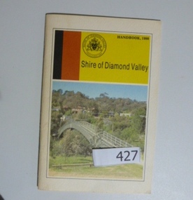 Greensborough Historical Society
Book, Shire of Diamond Valley, Shire of Diamond Valley Handbook 1980, 1980_
Guide to services provided by Shire of Diamond Valley. The Shire of Diamond Valley was a Local Government Area located about 20 kilometres northeast of Melbourne. The shire covered an area of 74.38 square kilometres and existed from 1964 until 1994Annual guide to services in Shire of Diamond Valley32 pages, col illus., maps. Cover illustration of footbridge over the Plenty River at Flintoff Street. The span is 50 metres and cost $56,100 to build in 1978.shire of diamond valley, greensborough, handbooks -
 Eltham District Historical Society Inc
Photograph, Shoestring
Stamped on back: Neville F. Emerson Estate Agent 81 Main Rd. Lower Plenty. Inscribed with the name JoyceBlack and white photographhouses, neville emerson real estate, shoestring -
 Eltham District Historical Society Inc
Photograph, Unidentified house, possibly Eltham area
Stamped on back: Neville F. Emerson Estate Agent 81 Main Rd. Lower Plenty. Inscribed with the name JoyceBlack and white photographhouses, neville emerson real estate -
 Eltham District Historical Society Inc
Photograph, Unidentified house, possibly Eltham area
Stamped on back: Neville F. Emerson Estate Agent 81 Main Rd. Lower Plenty. Inscribed with the name JoyceBlack and white photographhouses, neville emerson real estate -
 Eltham District Historical Society Inc
Photograph, Unidentified house, possibly Eltham area
Stamped on back: Neville F. Emerson Estate Agent 81 Main Rd. Lower Plenty. Inscribed with the name JoyceBlack and white photographhouses, neville emerson real estate -
 Eltham District Historical Society Inc
Photograph, Shoestring
Stamped on back: Neville F. Emerson Estate Agent 81 Main Rd. Lower Plenty. Inscribed with the name JoyceBlack and white photographhouses, neville emerson real estate, shoestring -
 Hume City Civic Collection
Photograph, 1/08/1980
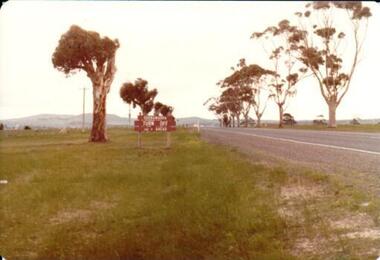
On 4th August 1978 the construction of the Goonawarra Estate commenced. The estate was formerly known as the Goonawarra Farm and overlooked the Sunbury town and the Jacksons Creek valley. Plans for the development included a golf course, houses, community and recreational facilities..The golf course opened in 1980 and the housing construction continued throughout the last two decadesd of the twentieth century and into the twenty firsat century.A coloured photograph showing the signpost indicating the entrance to the Goonawarra Estate from Sunbury Road. Trees are growing on either side of the road and Mt. Holden can be seen across the skyline.goona warra golf club, goonawarra farm, goonawarra housing estate, sharkey, robert b., kilkenny homes, australian ideas homes pty.ltd., craftsmen homes., glamor homes, villa bella homes, mt. holden, george evans collection -
 Bendigo Historical Society Inc.
Map - JACK FLYNN COLLECTION: TOWNSHIP OF STANHOPE, December 1950
Map: Township of Stanhope, Parish of Girgarre, County of Rodney. Parish plan.By Authority J. J. Gourley, Government Printer, Melbourne. Drawn and Reproduced at the Dept, of Lands and Survey, Melbourne, Victoria.map, rodney, township, stanhope -
 Bendigo Historical Society Inc.
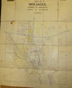
Map - JACK FLYNN COLLECTION: MOLIAGUL, 7/02/1931
Map: Township of Moliagul, Parish of Moliagul, County of Gladstone. Parish plan.map, gladstone, township, moliagul -
 Bendigo Historical Society Inc.
Map - JACK FLYNN COLLECTION: GIRGARRE, 1957
Map: Township of Girgarre, Parish of Kyabram, County of Rodney. Parish plan.By Authority: W. M. Houston, Government Printer, Melbourne. Drawn and reproduced at the Department of Lands and Survey, Melbourne.map, rodney, township, girgarre -
 Bendigo Historical Society Inc.
Map - JACK FLYNN COLLECTION: GOORNONG, August 1953
Map: Township of Goornong, Parish of Goornong, County of Bendigo. Parish plan.By Authority W.M. Houston. Government Printer. Drawn and Reproduced at the Dept., of Lands and Survey, Melbourne, Victoria. August 1953map, bendigo, township, goornong -
Bendigo Historical Society Inc.
Map - MANDURANG, No date visible
Map: It has the Village of Mandurang on one side and the Township of Laanecoorie on the reversemap, bendigo, parish plan, mandurang, laanecoorie -
Lakes Entrance Regional Historical Society (operating as Lakes Entrance History Centre & Museum)
Book, Rule Hilda, Back to Nowa Nowa, 1980
A short history of the timber township of Nowa Nowa, East Gippsland Victoria.township, settlers, timber industry, schools, transport -
Lakes Entrance Regional Historical Society (operating as Lakes Entrance History Centre & Museum)
Book, Bundalaguah Centenary Committee, A Man from Gelantipy, 1972
A souvenir bokklet produced for the cenenary of the Parish and township of Bundalaguah Gippsland Victoriatownship, settlers, agriculture, education