Showing 3398 items matching " power"
-
 Ballarat Heritage Services
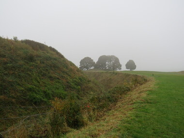
Photograph - Colour, Earth Banks, Old Sarum, England, 2016, 01 November 2016
William the Conqueror inherited Old Sarum from the last Saxon king of England. It was an ideal site for a royal castle. It was here in 1070 that William paid off his army after a long and bitter campaign in northern England. It was here in 1086 that he called together all the major landholders in England so they could swear allegiance to him. It was a crucial moment. The Domesday Book was being written, a threatened Viking invasion had only just been averted and William's eldest son was in armed rebellion. Old Sarum was an important place where this Norman king of England held power. In 1794 the Ordnance Survey set out to check the accuracy of the first mapping of Southern England, which had begun ten years earlier. From a point just below Old Sarum Lieutenant William Mudge laid out a base-line 36,574 feet (11,253 metres) long. From each end of the line the positions of distant places were plotted using a huge theodolite made in 1791 by Jesse Ramsden. The accuracy of the process, which was repeated all over England, depended on Jesse Ramsden's craftsmanship and on William Mudge's surveying skill in setting out this first base-line from Old Sarum. The nearer end of Mudge's line is marked by an inscribed stone beside the modern A345 at Old Sarum. ordnance survey, william mudge, jesse ramsden, william the conqueror, old sarum, saxon, 1086, england -
 Ballarat Heritage Services
Photograph - Photograph - Colour, Castle toilets, Old Sarum, England, 2016, 01/11/2016
William the Conqueror inherited Old Sarum from the last Saxon king of England. It was an ideal site for a royal castle. It was here in 1070 that William paid off his army after a long and bitter campaign in northern England. It was here in 1086 that he called together all the major landholders in England so they could swear allegiance to him. It was a crucial moment. The Domesday Book was being written, a threatened Viking invasion had only just been averted and William's eldest son was in armed rebellion. Old Sarum was an important place where this Norman king of England held power. In 1794 the Ordnance Survey set out to check the accuracy of the first mapping of Southern England, which had begun ten years earlier. From a point just below Old Sarum Lieutenant William Mudge laid out a base-line 36,574 feet (11,253 metres) long. From each end of the line the positions of distant places were plotted using a huge theodolite made in 1791 by Jesse Ramsden. The accuracy of the process, which was repeated all over England, depended on Jesse Ramsden's craftsmanship and on William Mudge's surveying skill in setting out this first base-line from Old Sarum. The nearer end of Mudge's line is marked by an inscribed stone beside the modern A345 at Old Sarum. Colour photographs of Castle toilets at Old Sarum, England. The toilets are constructed of stone. ordnance survey, william mudge, jesse ramsden, william the conqueror, old sarum, saxon, 1086, england, subjects, toilets -
 Ballarat Heritage Services
Photograph - Colour, Toilets, Old Sarum, England, English Heritage Site, 2016, 01 November 2016
William the Conqueror inherited Old Sarum from the last Saxon king of England. It was an ideal site for a royal castle. It was here in 1070 that William paid off his army after a long and bitter campaign in northern England. It was here in 1086 that he called together all the major landholders in England so they could swear allegiance to him. It was a crucial moment. The Domesday Book was being written, a threatened Viking invasion had only just been averted and William's eldest son was in armed rebellion. Old Sarum was an important place where this Norman king of England held power. In 1794 the Ordnance Survey set out to check the accuracy of the first mapping of Southern England, which had begun ten years earlier. From a point just below Old Sarum Lieutenant William Mudge laid out a base-line 36,574 feet (11,253 metres) long. From each end of the line the positions of distant places were plotted using a huge theodolite made in 1791 by Jesse Ramsden. The accuracy of the process, which was repeated all over England, depended on Jesse Ramsden's craftsmanship and on William Mudge's surveying skill in setting out this first base-line from Old Sarum. The nearer end of Mudge's line is marked by an inscribed stone beside the modern A345 at Old Sarum. ordnance survey, william mudge, jesse ramsden, william the conqueror, old sarum, saxon, 1086, england -
 Ballarat Heritage Services
Photograph - Colour, Stonework, Old Sarum, England, English Heritage Site, 2016, 01 November 2016
William the Conqueror inherited Old Sarum from the last Saxon king of England. It was an ideal site for a royal castle. It was here in 1070 that William paid off his army after a long and bitter campaign in northern England. It was here in 1086 that he called together all the major landholders in England so they could swear allegiance to him. It was a crucial moment. The Domesday Book was being written, a threatened Viking invasion had only just been averted and William's eldest son was in armed rebellion. Old Sarum was an important place where this Norman king of England held power. In 1794 the Ordnance Survey set out to check the accuracy of the first mapping of Southern England, which had begun ten years earlier. From a point just below Old Sarum Lieutenant William Mudge laid out a base-line 36,574 feet (11,253 metres) long. From each end of the line the positions of distant places were plotted using a huge theodolite made in 1791 by Jesse Ramsden. The accuracy of the process, which was repeated all over England, depended on Jesse Ramsden's craftsmanship and on William Mudge's surveying skill in setting out this first base-line from Old Sarum. The nearer end of Mudge's line is marked by an inscribed stone beside the modern A345 at Old Sarum. ordnance survey, william mudge, jesse ramsden, william the conqueror, old sarum, saxon, 1086, england -
 Ballarat Heritage Services
Photograph - Colour, looking from Stonework towards earth mounds, Old Sarum, England, English Heritage Site, 2016, 01 November 2016
William the Conqueror inherited Old Sarum from the last Saxon king of England. It was an ideal site for a royal castle. It was here in 1070 that William paid off his army after a long and bitter campaign in northern England. It was here in 1086 that he called together all the major landholders in England so they could swear allegiance to him. It was a crucial moment. The Domesday Book was being written, a threatened Viking invasion had only just been averted and William's eldest son was in armed rebellion. Old Sarum was an important place where this Norman king of England held power. In 1794 the Ordnance Survey set out to check the accuracy of the first mapping of Southern England, which had begun ten years earlier. From a point just below Old Sarum Lieutenant William Mudge laid out a base-line 36,574 feet (11,253 metres) long. From each end of the line the positions of distant places were plotted using a huge theodolite made in 1791 by Jesse Ramsden. The accuracy of the process, which was repeated all over England, depended on Jesse Ramsden's craftsmanship and on William Mudge's surveying skill in setting out this first base-line from Old Sarum. The nearer end of Mudge's line is marked by an inscribed stone beside the modern A345 at Old Sarum. ordnance survey, william mudge, jesse ramsden, william the conqueror, old sarum, saxon, 1086, england -
 Ballarat Heritage Services
Photograph - Colour, Looking from Stonework towards people walking on earth mounds, Old Sarum, England, English Heritage Site, 2016, 01 November 2016
William the Conqueror inherited Old Sarum from the last Saxon king of England. It was an ideal site for a royal castle. It was here in 1070 that William paid off his army after a long and bitter campaign in northern England. It was here in 1086 that he called together all the major landholders in England so they could swear allegiance to him. It was a crucial moment. The Domesday Book was being written, a threatened Viking invasion had only just been averted and William's eldest son was in armed rebellion. Old Sarum was an important place where this Norman king of England held power. In 1794 the Ordnance Survey set out to check the accuracy of the first mapping of Southern England, which had begun ten years earlier. From a point just below Old Sarum Lieutenant William Mudge laid out a base-line 36,574 feet (11,253 metres) long. From each end of the line the positions of distant places were plotted using a huge theodolite made in 1791 by Jesse Ramsden. The accuracy of the process, which was repeated all over England, depended on Jesse Ramsden's craftsmanship and on William Mudge's surveying skill in setting out this first base-line from Old Sarum. The nearer end of Mudge's line is marked by an inscribed stone beside the modern A345 at Old Sarum. ordnance survey, william mudge, jesse ramsden, william the conqueror, old sarum, saxon, 1086, england -
 Ballarat Heritage Services
Photograph - Colour, Stairs, Old Sarum, England, English Heritage Site, 2016, 01 November 2016
William the Conqueror inherited Old Sarum from the last Saxon king of England. It was an ideal site for a royal castle. It was here in 1070 that William paid off his army after a long and bitter campaign in northern England. It was here in 1086 that he called together all the major landholders in England so they could swear allegiance to him. It was a crucial moment. The Domesday Book was being written, a threatened Viking invasion had only just been averted and William's eldest son was in armed rebellion. Old Sarum was an important place where this Norman king of England held power. In 1794 the Ordnance Survey set out to check the accuracy of the first mapping of Southern England, which had begun ten years earlier. From a point just below Old Sarum Lieutenant William Mudge laid out a base-line 36,574 feet (11,253 metres) long. From each end of the line the positions of distant places were plotted using a huge theodolite made in 1791 by Jesse Ramsden. The accuracy of the process, which was repeated all over England, depended on Jesse Ramsden's craftsmanship and on William Mudge's surveying skill in setting out this first base-line from Old Sarum. The nearer end of Mudge's line is marked by an inscribed stone beside the modern A345 at Old Sarum. ordnance survey, william mudge, jesse ramsden, william the conqueror, old sarum, saxon, 1086, england -
 Ballarat Heritage Services
Photograph - Colour, Public toilets hidden in earth mound, Old Sarum, England, English Heritage Site, 2016, 01 November 2016
William the Conqueror inherited Old Sarum from the last Saxon king of England. It was an ideal site for a royal castle. It was here in 1070 that William paid off his army after a long and bitter campaign in northern England. It was here in 1086 that he called together all the major landholders in England so they could swear allegiance to him. It was a crucial moment. The Domesday Book was being written, a threatened Viking invasion had only just been averted and William's eldest son was in armed rebellion. Old Sarum was an important place where this Norman king of England held power. In 1794 the Ordnance Survey set out to check the accuracy of the first mapping of Southern England, which had begun ten years earlier. From a point just below Old Sarum Lieutenant William Mudge laid out a base-line 36,574 feet (11,253 metres) long. From each end of the line the positions of distant places were plotted using a huge theodolite made in 1791 by Jesse Ramsden. The accuracy of the process, which was repeated all over England, depended on Jesse Ramsden's craftsmanship and on William Mudge's surveying skill in setting out this first base-line from Old Sarum. The nearer end of Mudge's line is marked by an inscribed stone beside the modern A345 at Old Sarum. ordnance survey, william mudge, jesse ramsden, william the conqueror, old sarum, saxon, 1086, england -
 Ballarat Heritage Services
Photograph - Colour, Entrance to Public toilets hidden in earth mound, Old Sarum, England, English Heritage Site, 2016, 01 November 2016
William the Conqueror inherited Old Sarum from the last Saxon king of England. It was an ideal site for a royal castle. It was here in 1070 that William paid off his army after a long and bitter campaign in northern England. It was here in 1086 that he called together all the major landholders in England so they could swear allegiance to him. It was a crucial moment. The Domesday Book was being written, a threatened Viking invasion had only just been averted and William's eldest son was in armed rebellion. Old Sarum was an important place where this Norman king of England held power. In 1794 the Ordnance Survey set out to check the accuracy of the first mapping of Southern England, which had begun ten years earlier. From a point just below Old Sarum Lieutenant William Mudge laid out a base-line 36,574 feet (11,253 metres) long. From each end of the line the positions of distant places were plotted using a huge theodolite made in 1791 by Jesse Ramsden. The accuracy of the process, which was repeated all over England, depended on Jesse Ramsden's craftsmanship and on William Mudge's surveying skill in setting out this first base-line from Old Sarum. The nearer end of Mudge's line is marked by an inscribed stone beside the modern A345 at Old Sarum. ordnance survey, william mudge, jesse ramsden, william the conqueror, old sarum, saxon, 1086, england -
 Ballarat Heritage Services
Photograph - Colour, Masons' Marks, Old Sarum, England, English Heritage Site, 2016, 01 November 2016
William the Conqueror inherited Old Sarum from the last Saxon king of England. It was an ideal site for a royal castle. It was here in 1070 that William paid off his army after a long and bitter campaign in northern England. It was here in 1086 that he called together all the major landholders in England so they could swear allegiance to him. It was a crucial moment. The Domesday Book was being written, a threatened Viking invasion had only just been averted and William's eldest son was in armed rebellion. Old Sarum was an important place where this Norman king of England held power. In 1794 the Ordnance Survey set out to check the accuracy of the first mapping of Southern England, which had begun ten years earlier. From a point just below Old Sarum Lieutenant William Mudge laid out a base-line 36,574 feet (11,253 metres) long. From each end of the line the positions of distant places were plotted using a huge theodolite made in 1791 by Jesse Ramsden. The accuracy of the process, which was repeated all over England, depended on Jesse Ramsden's craftsmanship and on William Mudge's surveying skill in setting out this first base-line from Old Sarum. The nearer end of Mudge's line is marked by an inscribed stone beside the modern A345 at Old Sarum. ordnance survey, william mudge, jesse ramsden, william the conqueror, old sarum, saxon, 1086, england -
 Ballarat Heritage Services
Photograph - Colour, Masons' Marks, Old Sarum, England, English Heritage Site, 01 November 2016
William the Conqueror inherited Old Sarum from the last Saxon king of England. It was an ideal site for a royal castle. It was here in 1070 that William paid off his army after a long and bitter campaign in northern England. It was here in 1086 that he called together all the major landholders in England so they could swear allegiance to him. It was a crucial moment. The Domesday Book was being written, a threatened Viking invasion had only just been averted and William's eldest son was in armed rebellion. Old Sarum was an important place where this Norman king of England held power. In 1794 the Ordnance Survey set out to check the accuracy of the first mapping of Southern England, which had begun ten years earlier. From a point just below Old Sarum Lieutenant William Mudge laid out a base-line 36,574 feet (11,253 metres) long. From each end of the line the positions of distant places were plotted using a huge theodolite made in 1791 by Jesse Ramsden. The accuracy of the process, which was repeated all over England, depended on Jesse Ramsden's craftsmanship and on William Mudge's surveying skill in setting out this first base-line from Old Sarum. The nearer end of Mudge's line is marked by an inscribed stone beside the modern A345 at Old Sarum. ordnance survey, william mudge, jesse ramsden, william the conqueror, old sarum, saxon, 1086, england -
 Ballarat Heritage Services
Photograph - Colour, Masons' Marks, Old Sarum, England, English Heritage Site, 2016, 01 November 2016
William the Conqueror inherited Old Sarum from the last Saxon king of England. It was an ideal site for a royal castle. It was here in 1070 that William paid off his army after a long and bitter campaign in northern England. It was here in 1086 that he called together all the major landholders in England so they could swear allegiance to him. It was a crucial moment. The Domesday Book was being written, a threatened Viking invasion had only just been averted and William's eldest son was in armed rebellion. Old Sarum was an important place where this Norman king of England held power. In 1794 the Ordnance Survey set out to check the accuracy of the first mapping of Southern England, which had begun ten years earlier. From a point just below Old Sarum Lieutenant William Mudge laid out a base-line 36,574 feet (11,253 metres) long. From each end of the line the positions of distant places were plotted using a huge theodolite made in 1791 by Jesse Ramsden. The accuracy of the process, which was repeated all over England, depended on Jesse Ramsden's craftsmanship and on William Mudge's surveying skill in setting out this first base-line from Old Sarum. The nearer end of Mudge's line is marked by an inscribed stone beside the modern A345 at Old Sarum. ordnance survey, william mudge, jesse ramsden, william the conqueror, old sarum, saxon, 1086, england -
 Ballarat Heritage Services
Photograph - Colour, Masons' Marks, Old Sarum, England, English Heritage Site, 2016, 01 November 2016
William the Conqueror inherited Old Sarum from the last Saxon king of England. It was an ideal site for a royal castle. It was here in 1070 that William paid off his army after a long and bitter campaign in northern England. It was here in 1086 that he called together all the major landholders in England so they could swear allegiance to him. It was a crucial moment. The Domesday Book was being written, a threatened Viking invasion had only just been averted and William's eldest son was in armed rebellion. Old Sarum was an important place where this Norman king of England held power. In 1794 the Ordnance Survey set out to check the accuracy of the first mapping of Southern England, which had begun ten years earlier. From a point just below Old Sarum Lieutenant William Mudge laid out a base-line 36,574 feet (11,253 metres) long. From each end of the line the positions of distant places were plotted using a huge theodolite made in 1791 by Jesse Ramsden. The accuracy of the process, which was repeated all over England, depended on Jesse Ramsden's craftsmanship and on William Mudge's surveying skill in setting out this first base-line from Old Sarum. The nearer end of Mudge's line is marked by an inscribed stone beside the modern A345 at Old Sarum. ordnance survey, william mudge, jesse ramsden, william the conqueror, old sarum, saxon, 1086, england -
 Bendigo Historical Society Inc.
Mixed media - Bendigo Tramways 100th Anniversary National Trust DVD, 1990
The Sandhurst and Electric Tramway Company was the first to blaze a trail when it introduced battery trams to Bendigo in June 1890. Unfortunately they had made a serious miscalculation, as the batteries quickly proved inadequate for the hilly terrain of Bendigo. After a couple of months battery trams ceased running and were later replaced by steam trams in February 1892. Steam trams were a reliable means of transport and successfully moved Bendigonians around for ten years, but the onset of the recession forced the Bendigo Tramways Company to sell up in 1899 to the Electric Supply Company of Victoria (ESCo) who continued to run steam trams until 1902. This turn-of-the-century sale led to the introduction of electric trams to Bendigo in April 1903. These were a success from the very beginning. During peak hour people would be standing in the aisles, in the doorways, even on the running boards on the outside of the tram. In addition, the trams were also the first option for deliveries. Parcels, newspapers, movie reels for the picture theatres and even mail bags found their way onto the trams; sent from outlying post offices to the GPO in the city centre. At the end of World War I the Victorian Government constituted the new semi-government instrumentality, the State Electricity Commission of Victoria (SEC). The SEC was to take over all privately owned power generating companies in Victoria and operate as a state owned monopoly ... Bendigo's tramway system was an integral part of the deal.Bendigo Tramways 100th Anniversary National Trust 31 minute DVD. Content includes brief history of the Bendigo trams from 1890 to 1990; driver's view movies of each of the four Bendigo Lines; and the set up of the tourist trams after the closure of the lines by the State Electricity Commission of Victoria.history, bendigo, bendigo trams -
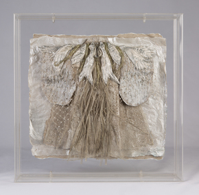 Ararat Gallery TAMA
Mixed media, Inga Hunter, Nrat-tuan Net Leader's Robe, 1986-1989
“A silver-grey robe, denoting a powerful official. The Netleader, or Netmaster, as he is sometimes called is head of one of the many craft guilds on Nrat-Tuan. Fishers Guilds are not only vital economic groups for Nrat-Tuan, but also for the whole Imperium, since the water planet is the major source of foodstuffs for Irusaqu, who cannot produce enough crops on what Is a relatively barren, planet. The various fishing crafts are most responsible occupations, entailing great care for the environment and the food chains. Fishing is carried out by means of either mirrors or nets, both being about equally popular. Mirror-faceted fabrics have always been used by Nrati-Tuan fishermen to dazzle and bemuse the creatures they are trying to catch, (the mirror may also have some predictive power). Research indicates that this odd technique is surprisingly effective. And the harvests are unfailingly good. Contact with the humans of Irusag, when the Imperium was first founded, brought the technique of netting to Nrat-Tuan. The Netleader heads the Netter Guild, which does not limit itself to the merely traditional fishing net, but works with a complex and sophisticated membrane technology, which has, in recent years, revolutionised the whole netting industry. The Master controls the experimental membrane laboratories, which deal with the extraction of metals from sea water, as well as with tools for the fishing industry.” -Inga Hunter -
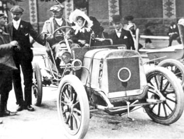 Surrey Hills Historical Society Collection
Photograph, Harley Tarrant and his 1905 Tarrant car, 1905
Col. Harley Tarrant was an astute businessman and a part-time soldier. He was born at Clunes in 1860 and as a young man worked with an engineering firm in Sydney. He later joined the Board of Works in Melbourne. and later entered the early car manufacturing and retailing trade. In 1905 Harley Tarrant built the first car to be built and sold in Australia. For a time he was a surveyor and worked in Surrey Hills but motoring became his prime interest. In the early 1890s he set up a workshop in what was then Post Office Place, Melbourne. He built stationary engines which ran on kerosene and in the first years of the twentieth century, with partner W Howard Lewis, built the first petrol driven car in Australia. This photo is of his sixth car and was taken after the finish of the 1st Sydney to Melbourne Dunlop Reliability Trial, which Tarrant won. Harley Tarrant produced cars between 1901 and 1907 at the Tarrant Motor and Engineering Company in Queen's Bridge Street, South Melbourne. The first car had a rear-mounted two-horse power Benz engine. Two-cylinder models were later produced followed by 4-cylinder models. The only Tarrant car in existence in 1984 was owned by Harley Tarrant's grandsons, Kenneth and Peter Holmes of Melbourne. The 1906 Tarrant car featured on an Australia Post stamp in 1984. It was one of a series of 5 stamps featuring Australian veteran and vintage cars.Black and white photo of a car without a hood in the driver's seat of which is a man with cap, driving dust coat and goggles, identified as Harley Tarrant. Beside him is a young girl in a large frilly; she is identified as Doreen Tarrant, his daughter. Another man with cap and goggles is talking to him and a gentleman in a bowler hat looks on. There is a women and 2 children in the background in front of a large brick wall decorated in two coloured bricks. cars, inventions, dunlop reliability trial, tarrant motor and engineering company, mr harley tarrant, miss doreen tarrant, mrs doreen holmes, col harley tarrant -
 Melton City Libraries
Document, Melton Fire Brigade 2013 Calendar, 2013
"From the beginnings of European settlement on the dry plains of Melton, the community became all too familiar with the destructive power of bushfires. Fires spread rapidly through the parched landscape and were difficult to stop. Small villages in the district were practically wiped out by different fires at various times, important buildings and valuable haystacks were lost, and most chaff mills were burned down more than once.110 A local bushfire brigade was established in 1935, with Constable Roy Corbett elected Captain. This formed the basis of what would later become the Melton Country Fire Authority (CFA) branch". During 1935 a Fire Brigade was organised by 1942 it had been registered with the BUSH FIRE BRIGADE COMMITTEE and a Certificate of Registration No 425 was issued. The Officers were as follows:- 1st Lieutenant E.W. Barrie 2nd Lieutenant T.L. Barrie 3rd Lieutenant Tom Knox Captains who followed Roy Corbett List of known Captains 1935 – 1975 Jack Wallace Roy Corbett Bon Barrie Edgar Barrie Steve Hirt In 1945 the C.F.A. became the controlling authority. Prior to this date D24 was the Nerve Centre of the Fire Fighting System with representatives of Country Fire Brigades, Forests Commission and D24. This information was in a typed document prepared by Edna Barrie 1975 Melton Fire Brigade yearly calendar emergency services -
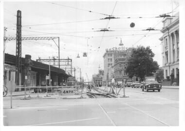 Melbourne Tram Museum
Photograph - Set of 12 - construction of King St overpass in Flinders St, 1959
Photos show the construction of King St overpass in Flinders St which was part of the project to construct a bridge over the Yarra River and provide a new southern outlet road between the city and eventually St Kilda Junction. The overpass construction was commenced in 1959 with tramway works first commencing. It was demolished in 2005. 1 - looking west at Market St. 2 - looking east from Spencer and Flinders St with the railway viaduct behind. 3 - Tram lines diverted onto the new overpass. Note the hand-powered overhead tower on the left behind the compressor. 4 - Tracks partially diverted. 5 - Looking east at Spencer and Flinders St with a Dunlop tyre truck in the view. 6 - prior to the diversion onto the new bridge. 7 - Looking east near William St. with W2 451 (Route 48, North Balwyn) in the view. 8 - Bridge works near King St. Original tracks still in use. 9 - Looking east prior to the introduction of the temporary tracks on the south side of the new overpass. 10 - SW6 852 and a W2 on new overpass trackwork - old trackwork being demolished. 11 - Cross over at Spencer St in Flinders St, prior to change over. 12 - Looking west at Flinders and Spencer St with SW6 853 turning into Spencer St.Yields information about the construction of the King St overpass in Flinders St during 1959.Set of 12 black and white prints of the construction of the King St overpass in Flinders St.trams, tramways, flinders st, king st overpass, construction, bridges, w2 class, sw6 class, tram 451, tram 853, tram 852 -
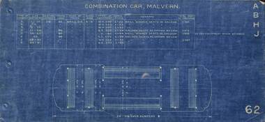 Melbourne Tram Museum
Drawing - Tramcar floor plans to 1923, Melbourne & Metropolitan Tramways Board (MMTB), c1924
Set of 16 floor plans of electric trams of the MMTB and the trusts from the A class of 1910 to W class of 1923. Shows floor plan, seats and a table with car numbers, loading, truck type, type of equipment, horse power, remarks and total weight. 1 - Malvern Combination - A, B, H, J classes 2 - Drop centre cars - Malvern - C, E and D classes 3 - Summer car - Malvern - F class 4 - Short saloon combination - Malvern G class 5 - Short saloon combination - Malvern K class 6 - Four motor bogie car - Malvern - L class 7 - Combination car - Hawthorn - M class 8 - Drop centre bogie car - Hawthorn - N and P class 9 - Closed bogie car - Hawthorn - O class 10 - Combination car, Preston - R and Q class 11 - Combination car, Coburg - S class 12 - Double saloon combination car - Coburg - T class 13 - Box Car Essendon U class 14 - Cross seat (toastrack) car, Essendon, V class 15 - Four motor bogie car - W class 16 - "Birney" Safety car - X class Plain copies - black on white paper held for all cars except the X class.Yields information about various classes of electric trams up to about 1923 that the MMTB absorbed from the Trusts and/or built themselves.Folder of 16 blue prints secured with three brass clips,tramways, tramcars, floor plans, drawings, a class, b class, c class, d class, e class, f class, g class, h class, k class, l class, m class, n class, o class, p class, q class, r class, s class, t class, u class, v class, x class, pmtt, htt, mbctt, fnptt -
 Ballarat Heritage Services
Photograph - Photograph - Colour, Earth Banks, Old Sarum, England, 01 November 2016
William the Conqueror inherited Old Sarum from the last Saxon king of England. It was an ideal site for a royal castle. It was here in 1070 that William paid off his army after a long and bitter campaign in northern England. It was here in 1086 that he called together all the major landholders in England so they could swear allegiance to him. It was a crucial moment. The Domesday Book was being written, a threatened Viking invasion had only just been averted and William's eldest son was in armed rebellion. Old Sarum was an important place where this Norman king of England held power. In 1794 the Ordnance Survey set out to check the accuracy of the first mapping of Southern England, which had begun ten years earlier. From a point just below Old Sarum Lieutenant William Mudge laid out a base-line 36,574 feet (11,253 metres) long. From each end of the line the positions of distant places were plotted using a huge theodolite made in 1791 by Jesse Ramsden. The accuracy of the process, which was repeated all over England, depended on Jesse Ramsden's craftsmanship and on William Mudge's surveying skill in setting out this first base-line from Old Sarum. The nearer end of Mudge's line is marked by an inscribed stone beside the modern A345 at Old Sarum. Colour photograph of Earth Banks, Old Sarum, Englandordnance survey, william mudge, jesse ramsden, william the conqueror, old sarum, saxon, 1086, england -
 The Beechworth Burke Museum
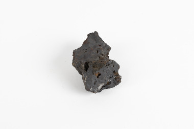
Geological specimen - Hematite (iron oxide)
Hematite is an iron ore significant for its high iron content (70%) and as being one of the two main iron oxide minerals, the other being magnetite. Hematite has a rating of 5-6 on the Moh's hardness scale and is often found as an accessory mineral in many igneous rocks. (an accessory mineral being "any mineral in an igneous rock not essential to the naming of the rock" - Britannica) Hematite has historically been the mainstay of South Australia’s iron ore production. (Magnetite: South Australia’s potential) Making up the eastern section of the Gawler Rangers, the Middleback Range is a mountain range on the eastern side of Eyre Peninsula in South Australia that has been a source of iron ore (its main commodity in minerals) for over a century. (see https://www.mindat.org/loc-22576.html). "Large reserves of high-grade iron ore were identified in 1890 in the Middleback Range, west of Whyalla. From 1915 these ores were shipped to Newcastle and later to Port Kembla, both in New South Wales. Local production of pig iron began when the first blast furnace was opened at Whyalla in 1941, and construction of an integrated iron and steel plant began there in 1958." (Britannica, South Australia: Resources and power). This area is home to 24 mines/mineral deposits (according to mindat.org, thought the Sarig Map provided by SA gov on their Energy and Mining website indicates significantly more mining leases).This mineral specimen was collected from the Middleback Ranges before the area was identified as holding large reserves of iron ore and being commercially mined and is representative of South Australia's significant and ongoing history of iron ore mining, and its contribution to Australia's steel manufacturing industry of the early 20th century (this specimen being collected in the prelude to these events).A small ferric oxide mineral composition a mid-blue-grey in colour with specks of rust-brown throughout.HEMATITE / (iron oxide) / Locality: Middleback Ranges, S. Aust.middleback ranges, iron ore mining, mining, south australia -
The Ed Muirhead Physics Museum
Rotating Anode X-ray Tube
The investigation of the x-ray appears early on to have been a priority research topic at the University of Melbourne’s School of Physics. This interest was sparked by the appointment in 1889 of Professor T.R. Lyle. Lyle, who was head of the school until 1915, is thought to have been the first person in Australia to have taken an x-ray photograph. A copy of this photograph can be found in the School of Physics Archive. For this particular experiment Lyle actually made his own x-ray tube. His successor, Professor Laby, continued to work with x-rays. During the 1920s Laby worked on the x-ray spectra of atoms and in 1930 he co-published with Dr. C.E. Eddy, Quantitative Analysis by X-Ray Spectroscopy. Also with Eddy, Laby produced the landmark paper Sensitivity of Atomic Analysis by X-rays. Laby went on to have an x-ray spectrograph of his own design manufactured by Adam Hilger Ltd. (see cat. No. 38). School of Physics, the University of Melbourne Cat. No. 22. Jacqueline Eager Student Projects Placement, Cultural Collections 2005 A modern X-ray tube differs little from the original Coolidge tube. A minor modification is the rotating anode type that extends the life and increases the available power of the tube by presenting a new portion of the anode when required. “P125/20/40/NrF038803 (?) SIEMENS-REINIGER-WERRE AG ERLANGEN Eigen filleung (?) mind. 0,7 mm AL” On rotating shaft: “FO/33803” On cathode: “23C” -
 Ballarat Tramway Museum
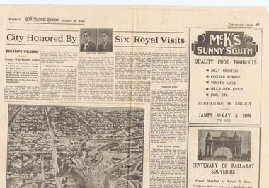
Newspaper, The Courier Ballarat, City Honored by six Royal Visits, Mar. 1938
Yields information about Ballarat and its locations or environs late 1938.Pages 11,12, 19 and 20 of the centenary of settlement in the Ballarat district by the Ballarat Courier - March 1938. See also items 186, 198 and 199. Page 11 Royal visits, banking in Ballarat, photos - NW section of Ballarat, railway station in foreground. Ads for J.McKay and Son, Roy Reeds (Men's store) and Ballarat Gas Co. Also photo of "The Corner" in Sturt St. - old Mining Exchange. Page 12 - full page ad for Morseheads, women's store. Page 19 - articles - Ballarat Lighting and Power, ESCo, SEC, electric trams. photos of the Arch of Victory, first electric tram, Lake Wendouree. Advertisements for Austin Spears (cycles), McDougall and Chisholm (drapers), W.E. Longhurst (bread) and the ES&A bank. Also article on South St. Society - music and elocution. Page 20 - articles - Ballarat Gas Co., horse and electric trams, agriculture in district and Ballarat's war record (WWI). Photos of work at Gong Gong Reservoir and Committeemen of the Ballarat Horticultural Society - 1859 to 1885. Ads for Ballarat College, Clarendon, Queens (girls) and Ballarat Grammar schools, Ern Craig Motors (Vauxhall) and Snows men's wear. Record reviewed and images of pages added 7-9-2013 and 10-9-2013trams, tramways, ballarat electricity, centenary, banking, transport, trams, esco -
 Tarnagulla History Archive
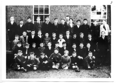
Students at Tarnagulla School, c.1923-1924, not dated, probably c.1923-1924
Murray Comrie Collection.Monochrome photograph of a group of children assembled in rows for a school photograph. Accompanied by two sets of handwritten notes (catalogued separately as a Research Notes) with children's names. Names of children combined from both set of notes are believed to be: Left to Right Back/4th row: Maurice Chambers, Alf Gedling, Bill Riordan, Les Williams, Wally Harwood, Len Smith, Les Caldwell, (at rear, Headmaster/teacher W.Carroll), Angus Comrie, Keith Comrie, Ken McKenzie, Bert Caldwell, Maurice Power. 3rd row: George Banks, Bruce Calder, J. Austin, Les Hutchins, Bill Gedling, Gilbert Ramm, Sydney Goltz, Murray Comrie, Tom Comrie, Bill Whimpey, Jim Duggan, Reuben Ampfer. 2nd row: Theo Riordan, N. Carroll, Andy Heraud, K.Calder, Keith Chambers, Harry James, Ron Heraud, Mal Ampfer, Stan McNamee, Bert Stevens (or Stephens). Front/1st row: _______ Calder, Rob Banks, L. Carroll, George Riordan, Bill Stevens (or Stephens), Len McKenna, A. Whimpey.tarnagulla, school, education, children, ampfer, banks, calder, caldwell, carroll, chambers, comrie, duggan, gedling, harwood, heraud, james, mckenna, mcnamee, riordan, smith, stephens, stevens, whimpey, williams -
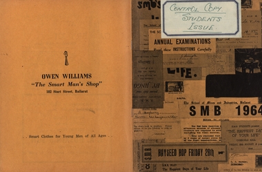 Federation University Historical Collection
Booklet, Ballarat School of Mines Students' Magazine, 1964, 1964
Ballarat School of Mines Students' Magazine was a Students' Association magazine. The president was G.N. Hart and the 1964 editors were Kelvin Whitford and Armand Krastins. The cover was designed by Colin Jellet. Advertising was obtained by Jon McDonald and Peter Smith. Active collaborators were John Costa, Ken Delany, Roger Lonsdale, John Byrne and Bobby Ong Gim Sen. Harry Arblaster retired in 1964 as the Principal of the Ballarat School of Mines, and E.J. Barker was appointed in his place. The Vice-Principal was H.J. TrudingerYellow/orange soft covered book of 96 pages. Articles include: Initiation, The creative Personality, Folk Singing by the Miners, SMB Silent Movies Inc., Red Roar and the Commie Threat, Paleopyrology, Conventional Wisdom, B-Day, The Malaysian Student in Australia, Moral Heresy, Sport, The Past and the Future?, The Possibility of Fusion Power, School Council, Members of Staff, list of full time diploma students. Those who had diplomas conferred were listed, as were the prize winners. Snippets: D.M. Pollard won the R.W. Richards Medal; John Costa was SRC Secretary, Jon McDonald was SRC President Images are named and include student activities Advertisement include: Ronaldson Brothers and Tippett; Electrolytic Zinc Company, Myers, Mount Isa Mines, Austaluco Aluminium, Owen's of Ballarat, Alexandria Tea Rooms, Roy Brack's Men's Wear, Lamanz, A.J. William Electrical Instruments, H.B. Selby, M.G. Taylor, T.J. Coutts, Ballaarat Gas Company, H.A. Davis Motor Service, Henderson-Palmer, Coca-Cola, Philps Electrical Industries, the Wattle, Eclipse Motors, BHP, M.B. John & Hattersley, Sheffield's Record Bar, Andrew Gault, Tait Book Company, Broken Hill Associated Smelters, Ballarat Colour Centre, Morsheads, Commonwealth Aircraft Corporation, J.J. Mortimer, Ewins, Gallery 321, J.a. Hoskinballarat school of mines, students' association, ray windmill, kelvin whitford, jennifer boyd, malcolm park, jutta bacsak, noel brady, gloria medlyn, ken felstead, jan butterworth, wayne collins, diana berry, lora richter, arblaster, stephen drew, judi woodward, michael moissinac, marilyn barclay, jon mcdonald, gloria roberts, ratnam nachiappan, jeni milbourne, daila berzins, bernard livingston, trudinger, barker, ballarat asian students' association, margaret leong, yew har ong, william cheng, elen leong, joan wright, poh teck shen, kristine goodier, kok fong ho, robert grub, tan joo lim, craig's royal hotel, tim joo lim -
 Kiewa Valley Historical Society
Photos - King Family Collection
The King family lived in Tawonga South where my older brother and sister went to school. We lived over the road from Wally Madison's farm. Later when a house became available, we moved into Valley Avenue, Mt Beauty. This is when I turned 5 and started my schooling. It was a long walk for a 5 year old as I remember. Then later we moved to 50 Lakeside Ave. I remember we loved living there as it was close to the school, footy ground and kindergarten. My father, Ted King, wad a carpenter and was involved in the building of many houses in Mt Beauty which was the home for the workers on the Kiewa Electric Scheme. So as they are part of the history of Mt Beauty I thought they may be useful to you as part of the history. The tennis photos, I vaguely remember Lou Hoad and Ken Rosewell giving exhibition matches in Mt Beauty. I may stand corrected on this, but I do remember my parents who were keen tennis players themselves were most excited at seeing these famous tennis players. As I was only 9 when we left Mt Beauty to live in Dimboola I still remember the shock of leaving a beautiful mountainous county side and arriving in a flat farming land next to a desert and seeing windmills One thing I do remember from school is, once a week (or fortnight) the teacher used to come around with a jar of little white pills, of which we were all to take. I really don't know what they were?? or for?? I also remember being taught to swim in the freezing cold river by a Mrs Smith who wore black bathers and wore her hair in a bun...... ...I am now in my 70s My father used to also carve intricate trays and jewellery boxes in his spare time. I think they were used for tennis trophies. by Diane Werner.x33 photos of small black and white photos of the Tawonga, Tawonga South and Mt Beauty - Photos not labelled but described as follows. See each photo for a possible label. A. Tawonga? B. Mt Beauty taken on the road to Bogong ? C. SEC Works D. Industrial buildings with mountains in the background E. Building site with wooden frame and 3 men F. Buildings with power poles G. Building site with lots of huts H. Buildings under construction I. Group of houses in the distance J. Group of houses in the distance K. Group of people in front of a building L. Group of 8 men sitting on timber planks, corrugated iron at back. M.& N. Building site with floor and upright timbers O. Mountain view with camp site in foreground P.& Q. Buiding site, several houses R.5 men at a building site S. portable building on trailer T & U. Mountain view V. Building site W. Group of men, car and mountains in background X. Cows Y. Pigs Z. 2 men standing next to cars. AA. Football players BB. Man painting a corrugated iron building CC. Football DD. Men in front of a building EE Buildings with mountains in background FF & GG Tennis payersHH & II. Electricity infrastructure -
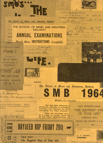 Federation University Historical Collection
Magazine - Booklet, Ballarat School of Mines Students' Magazine, 1964, 1964
Ballarat School of Mines Students' Magazine was a Students' Association magazine. The president was G.N. Hart and the 1964 editors were Kelvin Whitford and Armand Krastins. The cover was designed by Colin Jellet. Advertising was obtained by Jon McDonald and Peter Smith. Active collaborators were John Costa, Ken Delany, Roger Lonsdale, John Byrne and Bobby Ong Gim Sen. Harry Arblaster retired in 1964 as the Principal of the Ballarat School of Mines, and E.J. Barker was appointed in his place. The Vice-Principal was H.J. TrudingerYellow/orange soft covered book of 96 pages. Articles include: Initiation, The creative Personality, Folk Singing by the Miners, SMB Silent Movies Inc., Red Roar and the Commie Threat, Paleopyrology, Conventional Wisdom, B-Day, The Malaysian Student in Australia, Moral Heresy, Sport, The Past and the Future?, The Possibility of Fusion Power, School Council, Members of Staff, list of full time diploma students. Those who had diplomas conferred were listed, as were the prize winners. Snippets: D.M. Pollard won the R.W. Richards Medal; John Costa was SRC Secretary, Jon McDonald was SRC President Images are named and include student activities Advertisement include: Ronaldson Brothers and Tippett; Electrolytic Zinc Company, Myers, Mount Isa Mines, Austaluco Aluminium, Owen's of Ballarat, Alexandria Tea Rooms, Roy Brack's Men's Wear, Lamanz, A.J. William Electrical Instruments, H.B. Selby, M.G. Taylor, T.J. Coutts, Ballaarat Gas Company, H.A. Davis Motor Service, Henderson-Palmer, Coca-Cola, Philps Electrical Industries, the Wattle, Eclipse Motors, BHP, M.B. John & Hattersley, Sheffield's Record Bar, Andrew Gault, Tait Book Company, Broken Hill Associated Smelters, Ballarat Colour Centre, Morsheads, Commonwealth Aircraft Corporation, J.J. Mortimer, Ewins, Gallery 321, J.A. Hoskinballarat school of mines, students' association, ray windmill, kelvin whitford, jennifer boyd, malcolm park, jutta bacsak, noel brady, gloria medlyn, ken felstead, jan butterworth, wayne collins, diana berry, lora richter, arblaster, stephen drew, judi woodward, michael moissinac, marilyn barclay, jon mcdonald, gloria roberts, ratnam nachiappan, jeni milbourne, daila berzins, bernard livingston, trudinger, barker, ballarat asian students' association, margaret leong, yew har ong, william cheng, elen leong, joan wright, poh teck shen, kristine goodier, kok fong ho, robert grub, tan joo lim, eric mcgrath award, kevin whitford, ronaldson brothers and tippett, electrolytic zinc company, myers, mount isa mines, austaluco aluminium, owen's of ballarat, alexandria tea rooms, roy brack's men's wear, lamanz, a.j. william electrical instruments, h.b. selby, m.g. taylor, t.j. coutts, ballaarat gas company, h.a. davis motor service, henderson-palmer, coca-cola, philps electrical industries, the wattle, eclipse motors, bhp, m.b. john & hattersley, sheffield's record bar, andrew gault, tait book company, broken hill associated smelters, ballarat colour centre, morsheads, commonwealth aircraft corporation, j.j. mortimer, ewins, gallery 321, j.a. hoskin