Showing 3762 items
matching surveyed
-
 Warrnambool and District Historical Society Inc.
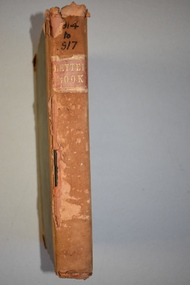
Letter book 6, Jan 1914 - 1917, 1914
This letter book contains letters, plans and sketch maps dating from 1914 to 1917. It came from the office of John William Crawley Junior, an engineer, architect and surveyor in private practice in Warrnambool and also the engineer for the Shire of Warrnambool from 1895 to 1935. His father, brother and son were also engineers and worked in that capacity or as the Shire Secretary for the Shire of Warrnambool, with the Crawley family recording a total of 132 years of service to the Shire of Warrnambool. This Shire existed from 1863 to 1994. The letter book was passed on the John Crawley’s son, Rolf, engineer for the Shire of Warrnambool from 1935 to 1968. It then came into the possession of Michael Hand who took over the private surveying practice of Rolf Crawley in Warrnambool. The Warrnambool and District Historical Society has acquired the letter book, along with several other Crawley ledgers, from the Michael Hand estate. This letter book is of considerable significance as it contains letters, maps and plans drawn up by John William Crawley, Junior, the engineer for the Shire of Warrnambool for 40 years. It will be very useful for researchers. This is a brown hard cover letter book with leather binding on the edges of the cover and on the spine. The leather is worn away in several places. There is gold lettering on the spine. The book has 750 pages of handwritten letters, maps and plans. The inside cover is of a mottled blue colour. There is an alphabetical index at the beginning of the book. ‘6’ ‘Letter Book 1914 to 1917’ john william crawley junior, warrnambool, rolf crawley, warrnambool, shire of warrnambool -
 Warrnambool and District Historical Society Inc.
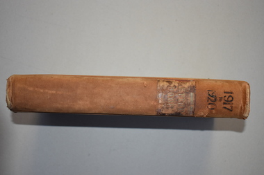
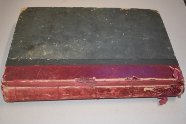
Letter book 7, 1917-1920, 1917
This letter book contains handwritten letters, sketch maps and plans and dates from 1917 to 1920. It comes from the office of John William Crawley Junior, an engineer, architect and surveyor in private practice in Warrnambool and also the engineer for the Shire of Warrnambool from 1895 to 1935. His father, brother and son were also engineers and worked in that capacity or as Shire Secretary for the Shire of Warrnambool, with the Crawley family recording 132 years of service with the Shire of Warrnambool. The Shire existed from 1863 to 1994. The letter book was passed on to John Crawley’s son, Rolf, the engineer for the Shire of Warrnambool from 1935 to 1968. The letter book then came into the possession of Michael Hand who took over the private surveying business of Rolf Crawley in Warrnambool. The Warrnambool and District Historical Society then acquired this letter book, along with other Crawley ledgers, from the Michael Hand estate. This letter book is of considerable significance as it contains letters, plans and maps drawn up John William Crawley Junior, the engineer for the Shire of Warrnambool for 40 years. It will be very useful for research. This is a hard cover book of 745 pages. It has leather trim on the cover edges and the spine with gold lettering on the spine. The leather covering is scuffed and torn. The inside covers have a mottled blue lining. The book contains maps, plans and handwritten letters and has an alphabetical index at the beginning of the book. Most of the pages have been water-stained. ‘7 Private’ ‘Letter Book 1917 to 1920’john william crawley junior, warrnambool, rolf crawley, warrnambool, shire of warrnambool -
 Warrnambool and District Historical Society Inc.
Letter book 8, Letters on Hyd Engineering
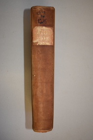
This book contains letters and mathematical computations on hydraulic engineering. The material has been compiled by Arnold Lilley (Lilly), an Oxford mathematician working in Victoria in the 1890s. It is said that he taught or coached 95% of the municipal surveyors in Victoria in the 1890s. The book came from the office of one of Lilley’s pupils, John William Crawley Junior, an engineer, surveyor and architect with a private practice in Warrnambool and also the engineer for the Shire of Warrnambool from 1895 to 1935. It is presumed that he had the letters bound in book form. The book passed to his son, Rolf Crawley, the engineer for the Shire of Warrnambool from 1935 to 1968. It later came into the possession of Michael Hand who took over the private surveying business of Rolf Crawley in Warrnambool. The Warrnambool and District Historical Society acquired the book, along with other Crawley ledgers, from the estate of Michael Hand.This book is of interest as a memento of the 1890s teachings of the mathematician, Arnold Lilley and also of his pupil, John William Crawley, the engineer for the Shire of Warrnambool for 40 years.This is a blue hard-cover book containing handwritten letters and computations. There are some loose pages and some pages have postal stamps on them. The book spine is slightly scuffed. ‘Letters on Hydraulic Engineering by Arnold Lilly Esq Mathematical Coach. J. Wm. Crawley Junior Pupil’rolf crawley, warrnambool, john william crawley junior, warrnambool, shire of warrnambool, arnold lilley, mathematician and teacher -
 Warrnambool and District Historical Society Inc.
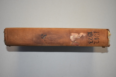
Ledger 10, Letters 1912 1923, 1912
This letter book contains letters and maps and dates from 1912 to 1923. It came from the office of John William Crawley Junior, an engineer, architect and surveyor in private practice in Warrnambool and also the engineer for the Shire of Warrnambool from 1895 to 1935. Hs father, brother and son were also engineers and worked in that capacity or as the Shire Secretary in the Shire of Warrnambool, with the Crawley family recording a total of 132 years of service to the Shire. The Shire of Warrnambool existed from 1863 to 1994. The letter book was passed on to John Crawley’s son, Rolf who was the engineer for the Shire of Warrnambool from 1935 to 1968. It then passed into the possession of Michael Hand who took over the private surveying practice of Rolf Crawley in Warrnambool. The Warrnambool and District Historical Society acquired the letter book, along with several other Crawley ledgers, from the estate of Michael Hand. This letter book is of considerable interest as it contains letters and maps drawn up by John William Crawley, a Shire of Warrnambool engineer for 40 years. It will be helpful to researchers. This is a black hard cover letter book with brown binding on the cover edges and the spine. Parts of the cover have been worn away. The spine once had gold lettering but this is mostly worn away. The book has 743 pages of handwritten letters and maps and an alphabetical index at the front. The pages are water stained.‘Letter Book 1912, 1923’john william crawley junior, warrnambool, rolf crawley, warrnambool, shire of warrnambool -
 Warrnambool and District Historical Society Inc.
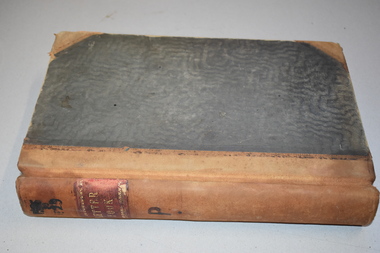
Letter book 11, Letters 1926 - 1929, 1926
This letter book contains handwritten letters and sketch maps and dates from 1926 to 1929. It came from the office of John William Crawley Junior, an engineer, surveyor and architect in private practice in Warrnambool and also the engineer for the Shire of Warrnambool from 1895 to 1935. His father, brother and son were also engineers and worked in that capacity or as the Shire Secretary for the Shire of Warrnambool, with the Crawley family recording a total of 132 years of service to the Shire. The Shire of Warrnambool existed from 1863 to 1994. The letter book was passed on to John Crawley’s son, Rolf, the engineer for the Shire of Warrnambool from 1935 to 1968. It then came into the possession of Michael Hand who took over the private surveying practice of Rolf Crawley. The Warrnambool and District Historical Society acquired the letter book, along with several other Crawley ledgers, from the estate of Michael Hand. This letter book is of considerable significance as it contains letters and maps drawn up by John William Crawley, Junior who had a private engineering and surveying practice in Warrnambool and was the engineer for the Shire of Warrnambool for 40 years. It will be very useful for researchers. This is a green hard cover letter book of 1000 pages. It has handwritten letters and sketch maps and an alphabetical index at the front. The cover has brown binding on the edges of the cover and the spine. There is gold lettering on the spine. The cover has an inside mottled red lining. There is a mauve stamp on the first page. ‘Letter Book 1926 to 1929’ ‘P’ ‘Rolf. L. Crawley, Civil Engineer, Drainage and Water Supply Engineer, Licensed Surveyor, Registered Architect, Warrnambool’ john william crawley junior, warrnambool, rolf crawley, warrnambool, shire of warrnambool -
 Warrnambool and District Historical Society Inc.
Copy of Titles, Thompson Print Co. Warrnambool, 1920s
This ledger contains copies of titles in the Warrnambool district, dating from 1916 to 1933. It came from the office of John William Crawley Junior, an engineer, surveyor and architect in private practice in Warrnambool and also the engineer for the Shire of Warrnambool from 1895 to 1935. His father, brother and son were all engineers, working in that capacity or as the Shire Secretary for the Shire of Warrnambool, with the Crawley family recording a total of 132 years of service to the Shire. The Shire of Warrnambool existed from 1863 to 1994. This ledger was passed on John Crawley’s son, Rolf, who was the engineer for the Shire of Warrnambool from 1935 to 1968. It then came into the possession of Michael Hand, who took over the private surveying business of Rolf Crawley in Warrnambool. The Warrnambool and District Historical Society acquired the ledger, along with several other Crawley ledgers, from the estate of Michael Hand. This ledger is of considerable importance as it contains copies of titles from the Warrnambool district in the early decades of the 20th century. It will be of great use for researchers.This is a hard cover book of 205 pages. The cover has red leather binding and is torn and scuffed. The book contains copies of titles and other handwritten and typed material and there are many loose titles, envelopes and miscellaneous sheets of paper. Inside the back cover is a booklet with an alphabetical index. This is pasted in. ‘Thompson Print Co. General Bookbinders Warrnambool’ ‘Copies of Titles John William Crawley Authorised & Licensed Surveyor December 1916’ john william crawley junior, warrnambool, rolf crawley, warrnambool, shire of warrnambool -
 Warrnambool and District Historical Society Inc.
Letter book 14, 1923
This letter book contains letters, sketch maps and plans and dates from 1923 to 1926. It came from the office of John William Crawley, Junior, an engineer, surveyor and architect in private practice in Warrnambool and also the engineer for the Shire of Warrnambool from 1895 to 1935. His father, brother and son were also engineers, working in that capacity or as the Shire Secretary for the Shire of Warrnambool, with the Crawley family recording a total of 132 years of service to the Shire. The Shire of Warrnambool existed from 1863 to 1994. This letter book was passed on to John Crawley’s son, Rolf, the engineer for the Shire of Warrnambool from 1935 to 1968. It then came into the possession of Michael Hand who took over the private surveying business of Rolf Crawley in Warrnambool. The Warrnambool and District Historical Society acquired the letter book, along with several other Crawley ledgers, from the estate of Michael Hand.This letter book is of considerable significance as it contains letters, maps and plans drawn up by John William Crawley, an engineer and surveyor in private practice in Warrnambool and the engineer for the Shire of Warrnambool for 40 years. It will be useful for researchers. This is a brown hard cover letter book of 1010 pages, with brown binding on the corners of the cover and on the spine. The cover is cuffed and torn. There is gold lettering on the spine. The book contains handwritten letters, maps and plans and an alphabetical index at the front, The pages are water-stained. There is a mauve stamp on the first page.‘Letter Book 1923 to 1926’ ‘J. Wm. Crawley Shire Hall Warrnambool (Private)’ ‘Rolf L. Crawley Civil Engineer, Drainage and Water Supply Engineer, Licensed Surveyor, Registered Architect, Warrnambool’ john william crawley junior, warrnambool, rolf crawley, warrnambool, shire of warrnambool -
 Warrnambool and District Historical Society Inc.
Letter book 15, 1920s
This letter book contains letters, sketch maps and plans and dates from 1929 to 1934. It came from the office of John William Crawley Junior, an engineer, surveyor, and architect in private practice in Warrnambool and also the engineer for the Shire of Warrnambool from 1895 to 1935. His father, brother and son were also engineers, working in that capacity or as Shire Secretary for the Shire of Warrnambool, with the Crawley family recording a total of 132 years of service to the Shire. The Shire of Warrnambool existed from 1863 to 1994. The letter book was passed on to John Crawley’s son, Rolf who was the engineer for the Shire of Warrnambool from 1935 to 1968. It then came into the possession of Michael Hand who took over the private surveying business of Rolf Crawley in Warrnambool. The Warrnambool and District Historical Society acquired the letter book, along with several other Crawley ledgers, from the estate of Michael Hand. This letter book is of considerable importance as it contains letters and maps from the late 1920s and 1930s and was compiled by John Crawley Junior, an engineer in the Shire of Warrnambool for 40 years. It will be a useful research tool. This is a hard-cover letter book of 1005 pages. It contains an alphabetical index at the front, handwritten letters, sketch maps and plans and some loose sheets. It has brown leather binding on the corners of the cover and on the spine but the spine covering is completely detached. The gold lettering on the spine is now almost completely obliterated. The cover is scuffed and torn. ‘Private Book’ ‘1929 to 1934’ john william crawley junior, warrnambool, rolf crawley, warrnambool, shire of warrnambool -
 Warrnambool and District Historical Society Inc.
Ledger, Crawley, 1919
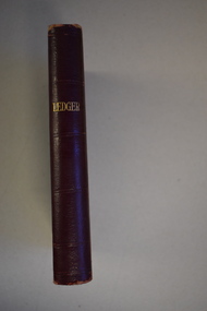
This ledger contains accounts and payment details and dates from 1919 to 1925. It came from the office of John William Crawley Junior, an engineer, surveyor and architect in private practice in Warrnambool and also the engineer for the Shire of Warrnambool from 1895 to 1935. His father, brother and son were all engineers and worked in that capacity or as the Shire Secretary of the Shire of Warrnambool, with the Crawley family recording a total of 132 years of service to the Shire. The Shire of Warrnambool existed from 1863 to 1994. This accounts book was passed on to John Crawley’s son, Rolf who was the engineer for the Shire of Warrnambool from 1935 to 1968. It then came into the possession of Michael Hand who took over the private surveying business of Rolf Crawley in Warrnambool. The Warrnambool and District Historical Society acquired the accounts book, together with several other Crawley ledgers, from the estate of Michael Hand. This book is of considerable interest as it contains details of the 1920s accounts and payments recorded by John William Crawley Junior, the engineer for the Shire of Warrnambool for 40 years. It will be useful for researchers.This is a black hard cover book of 132 pages. It has red binding on the corners of the cover and on the spine. There is gold lettering on the spine. The book has a brown mottled pattern inside the cover. The pages are ruled with red and blue lines and contain invoices and payment statements.‘Shire Office Warrnambool’ ‘J.Wm. Crawley & Son Warrnambool’ john william crawley junior, warrnambool, rolf crawley, warrnambool, shire of warrnambool -
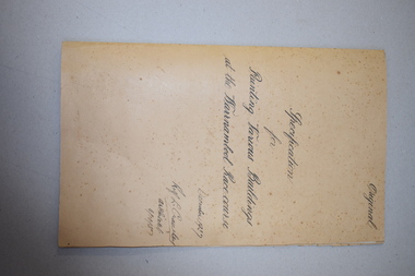 Warrnambool and District Historical Society Inc.
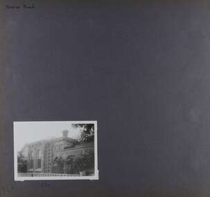
Documents, Rolf Crawley, Warrnambool, Warrnambool Race Course, 1920s and 30s
These documents deal with improvements in the 1920s and 30s (drainage, painting etc) to the Warrnambool Race Course. In 1854 the Warrnambool Racing Club was established and the first race meeting on the present day Warrnambool Race Course was held in 1858. These documents came from the office of Rolf Crawley, an engineer, architect and surveyor in private practice in Warrnambool and the engineer for the Shire of Warrnambool from 1935 to 1968. His grandfather, father and uncle were also engineers and worked in that capacity or as the Shire Secretary for the Shire of Warrnambool, with the Crawley family recording a total of 132 years of service to the Shire. The Shire of Warrnambool existed from 1863 to 1994. The documents came into the possession of Michael Hand who had taken over the private surveying business of Rolf Crawley in Warrnambool. The Warrnambool and District Historical Society acquired these documents and other Crawley material, from the Michael Hand estate. These documents are of considerable interest as they concern the Warrnambool Race Course improvements in the 1920s and 30s and come from the office of Rolf Crawley of Warrnambool. These are seven documents relating to the Warrnambool Race Course: .1 A manila folder with a handwritten title on the front cover and typed and printed material inside .2 A sketch map of the Warrnambool Race Course produced on heavy quality white paper. .3 Hand-drawn material on the underground drains on the Warrnambool Race Course produced on heavy quality white paper .4 & .5 Longitudinal section of the main drain, Warrnambool Race Course, produced on heavy quality white paper .6 Section of the drain near the fence and culvert of the Warrnambool Race Course produced on heavy quality paper .7 A piece of paper giving the chainage of the Warrnambool Race Course in red handwriting. warrnambool race course, rolf crawley, warrnambool -
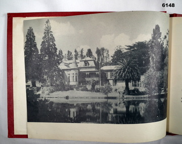
![Painting: Park Street [Adeney Avenue] Kew](/media/collectors/550653872162f11fb04854aa/items/5826877cd0cdd11284ad5413/item-media/614ac683a53a0756fd5e49da/item-fit-380x285.jpg) Kew Historical Society Inc
Kew Historical Society IncPainting, Park Street [Adeney Avenue] Kew, c. 1896
‘Adeney Avenue’ was the title given to this painting following its donation to the Kew Historical Society, yet the work’s origins predate the naming of Adeney Avenue in 1907 [originally gazetted as ‘Park Street’ (1865) and ‘Park Street South’ (1875).] Park Street ran between High Street and Parkhill Road beside what was later to become ‘Victoria Park’. This area was described in 1851 as “…a dense forest of gums and wattles which were to be largely cleared by 1888 after the naming of a recreation reserve”. The Reserve was still bisected by an unnamed creek in 1896, when the area was surveyed by the MMBW. The panoramic vista selected by the artist would appear to include ‘Eborensis’ (c.1895) on the corner of Parkhill Road and what was then Park Street, with views across cleared land towards the distant ranges. In the 19th century, north Kew was largely undeveloped farms stretching down to the Yarra. Oil on canvas by an unidentified artist of a panoramic view depicting what is now known as East Kew with mountains on the horizon. In the foreground is a two storey brick residence - Eborensis - located on the northeast corner of Parkhill Road and what is now Adeney Avenue. The view of the landscape and its rolling hills resulted from farming practices adopted following colonisation and settlement. Trees in the foreground and in the distance include remnant Eucalypts and introduced exotics.Label on rear of frame states "House on corner of Adeney Ave & Parkhill. [Regd. 254"]. Otherwise unsigned and undatedadeney avenue (kew), eborensis, park street (kew) -
 Flagstaff Hill Maritime Museum and Village
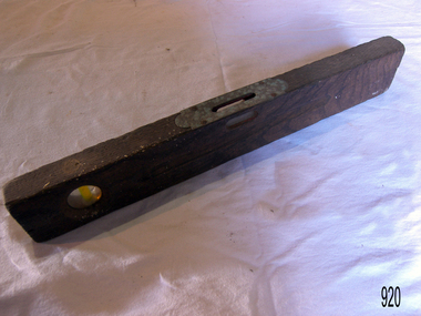
Tool - Spirit level, Early to mid-20th century
The tool is used for establishing a horizontal plane, it consists of a small glass tube containing alcohol or similar liquid and an air bubble. The tube is sealed and fixed horizontally in a wooden or metallic block or frame with a smooth lower surface. The glass tube is slightly bowed, and adjustment to the horizontal is indicated by the movement of the bubble. The device is on a level surface when the bubble is in the middle of the glass tube. The level sensitivity is proportional to the radius of the curvature of the glass. The spirit or bubble level consists of a sealed glass tube containing alcohol and an air bubble. It was invented in 1661 and was first used on telescopes and later on surveying instruments, but it did not become a carpenter's tool until the factory-made models were introduced in the mid-19th century. The circular level, in which a bubble floated under a circular glass to indicate the level in all directions, was invented in 1777. But It lacked the sensitivity of the conventional level.A hand tool that has not changed much since its invention in 1661, this tool is used today and although the materials it is made from have changed it's use has not.Spirit level wooden with two windows one of which has a piece of brass sheet metal protecting it.Noneflagstaff hill, warrnambool, flagstaff-hill, flagstaff-hill-maritime-museum, maritime-museum, shipwreck-coast, flagstaff-hill-maritime-village, hand tool, spirit level, carpenders tool, builders tool, surveyors instrument -
 Flagstaff Hill Maritime Museum and Village
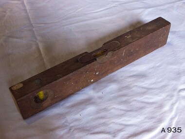
Tool - Level, Mid 19th to mid 20th century
The tool is used for establishing a horizontal plane, it consists of a small glass tube containing alcohol or similar liquid and an air bubble. The tube is sealed and fixed horizontally in a wooden or metallic block or frame with a smooth lower surface. The glass tube is slightly bowed, and adjustment to the horizontal is indicated by the movement of the bubble. The device is on a level surface when the bubble is in the middle of the glass tube. The level sensitivity is proportional to the radius of the curvature of the glass. The spirit or bubble level consists of a sealed glass tube containing alcohol and an air bubble. It was invented in 1661 and was first used on telescopes and later on surveying instruments, but it did not become a carpenter's tool until the factory-made models were introduced in the mid-19th century. The circular level, in which a bubble floated under a circular glass to indicate the level in all directions, was invented in 1777. But It lacked the sensitivity of the conventional level.A hand tool that has not changed much since its invention in 1661, this tool is used today and although the materials it is made from have changed it's use has not.Spirit level wooden has 2 glass levels, 1 horizontal & 1 vertical Noneflagstaff hill, warrnambool, shipwrecked-coast, flagstaff-hill, flagstaff-hill-maritime-museum, maritime-museum, shipwreck-coast, flagstaff-hill-maritime-village -
 Flagstaff Hill Maritime Museum and Village
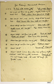
Document - Report, Jet Probings, Warrnambool Harbour, 16-10-1929
This report lists the depths of water and the consistency of the seabed surrounding the Warrnambool Harbour in October 1929, The information, often referred to as 'soundings', was obtained by Jet Probing,. In earlier days a lead line was used to perform a similar task. The author of the document is unknown. Jet Probing is a method used for underwater archaeology, cable installation and coastal engineering. A jet probe is a machine that produces a strong jet of water that penetrates the layers of sediment on the seabed, determining their depth, thickness and consistency. It provides a survey of the seabed and can be used as an aid to engineering design and construction. The report mentions lining up with the wooden jetty, the end of the breakwater and the leading lights. It mentions sand, loose rock and rock. It tells of stopping work due to the water being too rough, the pipe choking, difficulty in connecting pipes, and pipe joint breaking as it tried to get through the sand, The report in the document is significant for its connection with the Warrnambool Harbour, Warrnambool Breakwater, Warrnambool Jetty and Lady Bay. The report gives figures for the depth and consistency of the water and seabed at a particular point in time and can be used to compart with similar figures taken at different times. The results could determine plans for future engineering works.Report, titled 'Jet Probings, Warrnambool Harbour'. Two pages of cream coloured paper with hand written notes in pen and ink. Report covers three days of Jet Probings, with resulting figures and comments, for the depths of the surroundings of the Warrnambool Harbour. The report is in point form, with some underlining. Dates of recordings are 14-10-29, 15-10-29 and 16-10-29. (1929) The situation of the harbour had become a real problem by 1910 and required continuous dredging. In 1914 the Breakwater was extended but proved to be a failure because the work began to subside and by 1920 about two thirds of the harbour was silted up. Alterations made in the 1920's increased the silting problem. The soundings and Jet Probings were done after the Royal Commission of 1923, when the damaged stonework on the seaward side of the Warrnambool Breakwater, caused by the action of the sea, was the subject of enquiry. A conference between the Public Works, Water Commission and the Harbour Trust concluded that it would less costly to make repairs to prevent further damage rather than replaced the damage portion of the wall. A contract was raised in late 1924 to deposit rubble on the damaged side of the breakwater to minimise the Southern Ocean’s destructive action and work had started by August 1925. By the 1940's the harbour was no longer used. More alterations were made in the 1950's and 1960's. document, depth, warrnambool harbour, 1929, soundings, jet probe, jet probing, seabed, map of seabed, underwater engineering, warrnambool jetty, warrnambool breakwater, breakwater upgrade, leading lights, chart the harbour, flagstaff hill, warrnambool, flagstaff hill maritime museum & village, maritime museum, maritime village, shipwreck coast, lady bay, port of warrnambool, breakwater, jetty, pier, vhr h2024, royal commission, 1923, public works, water commission, harbour trust, victorian harbours -
 Federation University Historical Collection
Booklet, W. B. Macdonald, Ballarat School of Mines Annual Report 1889, 1889
Ballarat School of Mines Annual Report 1889. Annual Report, Crown Grant, Affiliation Statute, Constitution, Liabilities and Assets, Certificates Granted by Council, Fees, Honorary Correspondents, Life Governors, Meteorological Observations, Number of Students attended The School of Mines, Office Bearers, Report of the Curator of the Museum and Library, Report of the Superintendent of Laboratories, Report of the Lecturer on Engineering and Surveying, Report of the Lecturer on Freehand and Model Drawing, Report of the Lecturer on Telegraphy, Report of the Lecturer on Botany, Report of the Lecturer on Materia Medica and Physiology, Report of University Classes, Examinations Held, Scale of Charges for Assays and Analyses, Statement of Receipts and Expenditure for the year 1889 and Special Trust Funds, Statistics - Students attending Lectures, Subjects and Examiners, Subscriptions and Donations from 1st January to 31st December 1889, Time Table, Obituary - Sir William Foster Stawell and The Honorable Francis Ormond Ballarat School of Mines annual Report. Cover has brown marks on it, 106 pages. ballarat school of mines, annual report, andrew anderson j.p. - president, rivett henry bland - trustee, the hon. sir w. j. clarke - trustee, the hon. john warrington rogers - trustee, james oddie - trustee, the hon. henry cuthbert - honorary solicitor, i. j. jones - honorary treasurer, chas. kent - auditor, andrew berry - registrar, sir william foster stawell, the honorable francis ormond, alf. mica. smith - professor of chemistry, j. h. horwood - engineering and surveying, h. j. hall - geometrical and free hand drawing, w. d. campbell - telegraphy, george day - botany, j. f. usher - materia medica and physiology, bella guerin - university classes, henry krone - assistant registrar of titles, henry b. loch, paris school of mines -
 Bendigo Military Museum
Souvenir - Souvenir Booklet of Land Headquarters Cartographic Company, Australian Survey Corps "Fortuna" Bendigo 1942-45, Land Headquarters Cartographic Company, Australian Survey Corps, 1945
A Souvenir Booklet recording the Section photos and a Nominal roll of those who served 1942-45 at the Land Headquarters Cartographic Company, Australian Survey Corps located at "Fortuna Villa" Bendigo was produced at the end of WWII. Each member of the unit was presented with a copy of the booklet. The booklet besides being a great memory for those who served is a very valuable resource as it names the individuals in the photographs and very importantly records a Nominal Roll of unit members and their Military details. This booklet is one of those original booklets. The booklet has been reprinted on a number of occasions with different coloured covers. The first and original booklet had a red cover. Editions with brown, dark blue and black exist. The black covered edition was the last reprint. This booklet was donated by Carol Hargrave of Grenfell, NSW after discovering it in an old trunk that she purchased.A4 sized red cloth covered hard covered book mainly containing sub-unit photographs of section members and includes their names. 23 x double sided pages of photographs and 2 double sided pages of a Nominal Roll of those who served at Fortuna 1942 - 45. Each of the 50 pages were scanned at 600 dpi in JPEG (.jpg) format and stored on the attached 16GB USB Memory Stick. The images have been converted into MPEG-4 (.mp4) video format, 9Mb in size that runs for 4 Minutes and is also stored on the memory stick.royal australian survey corps, rasvy, fortuna, army survey regiment, army svy regt, asr -
 Bendigo Military Museum
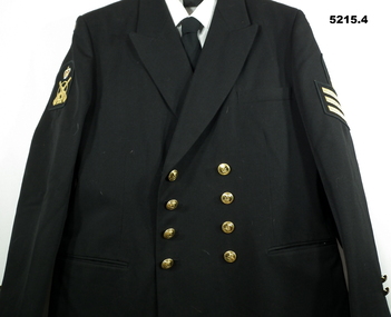
Uniform - UNIFORM, WINTER CEREMONIAL NAVY, ADA - Australian Defence Apparel, 1994-1996
David Dixon RAN R112262. Enlisted July 1972 as a Junior recruit age 15 years 9 months at HMAS Leeuwin. Passed out as Ordinary Seamen QMG and posted to HMAS Sydney 111 in Sept 1973. Jan 1974 - Feb 1981 with HMAS Derwent River Class Destroyer. Feb 1981 posted to HMAS Flinders Survey Ship. Sept 1981 promoted to Provisional Petty Officer QMG and then to HMAS Cerberus Gunnery School. Promoted to Petty Officer QMG then to HMAS Yarra 1984 then to HMAS Gladstone. Discharged from the RAN June 1987. Re Enlist 1996 and did a refresher course and posted to HMAS Success Fleet Tanker then HMAS Brisbane till 2001. Posted to HMAS Kuttabul with Recurring Back Injury and Discharged from the RAN May 2002. Total 21 years service with 17 off at Sea.1. Jacket - Black, Wool/Polyester, Insignias, yellow metal buttons. 2. Trousers - Black, Wool/Polyester. 3. Shirt - White, Polyester/Cotton. 4. Tie - Black, Polyester/Viscose. 5. Officers Peaked Cap - Plastic, White and Black, polyester, Elasticised band, Petty Officer Insignia.1. On Jacket - 3 stipes in gold braid. Petty Officer Insignia on Left Shoulder. Category Insignia on Right shoulder - Quartermaster Gunner.uniform, navy -
 Eltham District Historical Society Inc
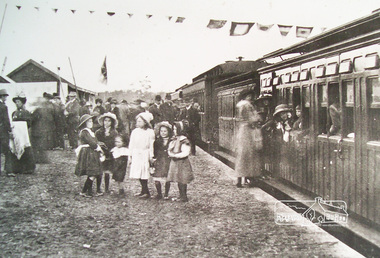
Photograph, Hurstbridge Railway Station, Opening Day, 25 June 1912
Despite inclement weather, up to 500 people attended the opening of the Eltham-Hurstbridge railway on 25 June 1912. Local member of parliament Ewen Cameron and Victorian Premier William Watt were present. Agitation for a railway extension began in 1888 when a meeting was held at Arthurs Creek to press for the construction of a railway line from Heidelberg to Kinglake. The Chairman Mr Charles Draper said this was necessary because this was the best fruit growing district in Victoria. Mr Cameron M.P. pointed out that whatever route the line took it would have to follow the Diamond Valley from Eltham. At the same time another meeting was pressing for the line to be extended to Queenstown (St Andrews). However when detailed surveys were made it was discovered that the only possible route was to Hurstbridge because of the hills. In 1912 the railway was opened terminating at Hurstbridge. Digital filerailway station, hurstbridge -
 Victorian Interpretive Projects Inc.
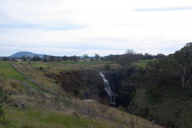
Photograph - Photograph - Colour, Clare Gervasoni, Lal Lal Falls, Victoria, 2014, 09/2014
Lal Lal Falls Reserve contains one of the most spectacular waterfalls in the Moorabool Shite. The watefall is part of the on Lal Lal Creek, a tributary of the Moorabool River. and plunges 30 metres from a high basalt column into a deep ravine. Culturally, the Falls are believed to be the earthly home of Bunjil, the All Father or Creator to most Victorian Aboriginal tribes. The name Lal Lal is thought to be Aboriginal for "dashing of waters". The Lal Lal Falls is listed on the Site Registry of Aboriginal Affairs Victoria as a spiritual place. in 1837 a Government Survey Party led by Frederick D'Arcy documented these Falls on the west branch of the Moorabool River. On the reserve opposite, a Race Meeting was held on every New Years Day from 1860 until 1938, attracting crowds of up to 20,000 people. A branch Railway Line was constructed from the Lal Lal station to the Racecourse to convey the crowds.Colour photographs of Lal Lal Falls near Ballarat, Victoria.lal lal falls, waterfall, lal lal, bunjil -
 Coal Creek Community Park & Museum
Honour Roll, Kilcunda Road School Honor Roll
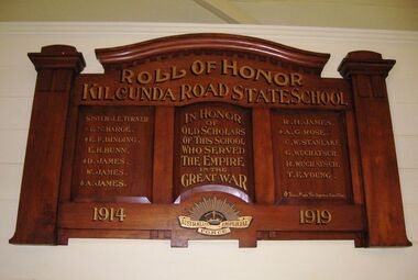
This WWI Honor Roll was originally displayed in the Kilcunda Road State School (no.3337), which was located at the north east corner of the intersection of the Bena - Kongwak and Buchanans' Roads, Bena, Victoria, 3946. The school was located amongst the cypress trees at 645 Bena-Kongwak Road. The school was relocated in 2008 to the Coal Creek Community Park and Museum, 12 Silkstone Road, Korumburra, 3950 to become the Masonic Lodge building in the park display. On the west side of the intersection of the Bena - Kongwak and Buchanans' Roads is a brass plaque on a granite boulder with the following inscription TO COMMEMORATE THE DISTRICT OF KILCUNDA ROAD First Surveyed 1879. This is the site of the KILCUNDA ROAD UNITING CHURCH 1911 to 1966. Diagonally opposite at 645 Bena-Kongwak Road was the site of the KILCUNDA ROAD PRIMARY SCHOOL No: 3337, 1902 to 1975. Erected by The School Mother’s Club continuing as The Kilcunda Road Social Club 2008. One of the few remaining historic items from Kilcunda Road settlement.Honour roll of varnished wood, with three panels, an undulating shaped pediment, plain columns at sides, painted gold text and the Australian Imperial Forces insignia on base.Roll of Honor, Kilcunda Road State School. In Honor of Old Scholars of this school who served the Empire in the Great War, 1914-1919, Australian Imperial Force. (X) These made the supreme sacrifice. Sister J.E. Turner , E.N. Barge, E.F. Binding (X), E.H. Bunn, D. James (X), W.James, A. James (X), R. H. James, A.G. Rose (X), C.W. Stanlake, G. Wuchatsch, R. Wuchatsch, T.E. Young kilcunda road, honour roll, state school no.3337., wwi -
 Melbourne Legacy
Document - Article, Legatee E K (Karl) Robertson, President 1980
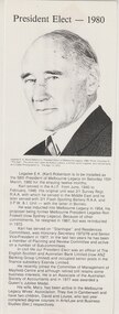
A cutting from from a Melbourne Legacy President's report showing a photo of Legatee Karl Robertson (President of Melbourne Legacy in 1980). It was collected to be a record of a photo of past presidents. Legatee Karl Robertson served in the AIF in World War 2, his original unit was 2/1 Survey Regt. RAA with which he served in the Middle East and he later served with 2/1 Flash Spotting Battery R A A and 3 P W and I Unit in Borneo. He was inducted into Melbourne Legacy in 1954 on the nomination of Legatee Ron Foskett. He stepped down between 1967 and 1972 when he was re-inducted. The article was part of an album of past presidents from 1965 to 1989. The folder included biographical details and obituaries, eulogies and death notices of prominent Legatees. The items have been catalogued separately.A record of Legatee Karl Robertson a past president of Legacy. The information was collected to record the lives of prominent legatees in a folder.Article with a black and white photo of Legatee Karl Robertson - President 1980.past presidents, karl robertson -
 Glen Eira Historical Society
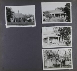
Album - Album page, Munster Avenue, Circa 1972
This photograph is part of the Caulfield Historical Album 1972. This album was created in approximately 1972 as part of a project by the Caulfield Historical Society to assist in identifying buildings worthy of preservation. The album is related to a Survey the Caulfield Historical Society developed in collaboration with the National Trust of Australia (Victoria) and Caulfield City Council to identify historic buildings within the City of Caulfield that warranted the protection of a National Trust Classification. Principal photographer thought to be Trevor Hart, member of Caulfield Historical Society. Most photographs were taken between 1966-1972 with a small number of photographs being older and from unknown sources. All photographs are black and white except where stated, with 386 photographs over 198 pages. This house continues to occupy the property at 5 Munster Avenue Carnegie (Google map image capture Feb 2019).Page 136 of Photograph Album with one landscape photograph of an Edwardian house on Munster Avenue.Handwritten: Munster Street / Avenue [top right] / 136 [bottom right]trevor hart, garden, verandah, bull nosed verandah, edwardian, coloured glass, corrugated iron roof, bay window, gable, chimneys, porch, munster avenue, carnegie, box bay window, weatherboards, cast iron work, timber houses -
 Glen Eira Historical Society
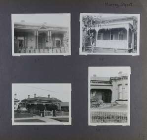
Album - Album page, Murray Street, Circa 1972
This photograph is part of the Caulfield Historical Album 1972. This album was created in approximately 1972 as part of a project by the Caulfield Historical Society to assist in identifying buildings worthy of preservation. The album is related to a Survey the Caulfield Historical Society developed in collaboration with the National Trust of Australia (Victoria) and Caulfield City Council to identify historic buildings within the City of Caulfield that warranted the protection of a National Trust Classification. Principal photographer thought to be Trevor Hart, member of Caulfield Historical Society. Most photographs were taken between 1966-1972 with a small number of photographs being older and from unknown sources. All photographs are black and white except where stated, with 386 photographs over 198 pages. Houses shown at 35, 58 and 32 Murray Street Elsternwick are still all extant (Google map image capture Dec 2018). Victorian Heritage Database - HO130 32 Murray Street Caulfield https://vhd.heritagecouncil.vic.gov.au/places/35535 (at 14/08/2021) No. 32 Murray Street is locally distinguished as the most imposing villa of its period in Murray Street whilst its association with J. W. Doyles, builder of several houses in the same street, is of interest. Its importance is enhanced by its substantially intact state.Page 138 of Photograph Album with four photographs (three landscape, one portrait) of 3 different houses on Murray Street. Handwritten: Murray Street [top right] / 35 [under top left photo] / 58 [under top right photo] / 32 [under bottom left photo] / 32 [under bottom right photo] / 138 [bottom right]trevor hart, garden, verandah, murray street, elsternwick, victorian style, houses, cast iron work, bay windows -
 Glen Eira Historical Society
Album - Album page, Neerim Road, Circa 1972
This photograph is part of the Caulfield Historical Album 1972. This album was created in approximately 1972 as part of a project by the Caulfield Historical Society to assist in identifying buildings worthy of preservation. The album is related to a Survey the Caulfield Historical Society developed in collaboration with the National Trust of Australia (Victoria) and Caulfield City Council to identify historic buildings within the City of Caulfield that warranted the protection of a National Trust Classification. Principal photographer thought to be Trevor Hart, member of Caulfield Historical Society. Most photographs were taken between 1966-1972 with a small number of photographs being older and from unknown sources. All photographs are black and white except where stated, with 386 photographs over 198 pages. "Edenkillie" was the home of Frederick Jowett, Caulfield's shire secretary and town clerk from 1887 to 1921. The Outer Circle Railway's Oakleigh section opened 1890 and closed 1895. Victorian Heritage database (as of 26/10/2021) HO45 Edenkillie https://vhd.heritagecouncil.vic.gov.au/places/35545 "Edenkillie" at 37 Neerim Road, Glenhuntly, is a substantial two storeyed polychrome brick villa, built for Frederick Jowett, municipal secretary, in 1890. It has aesthetic, historical and social significance. "Edenkillie's" aesthetic value derives from its survival as a substantially intact example of a common villa form expressed in polychrome brickwork. Its historical significance lies in its association with Frederick Jowett, Shire of Caulfield secretary and town clerk for over three decades. Its social significance is derived from the building's ability to demonstrate the kind of lifestyle which a local government administrator could enjoy during the Land Boom.Page 145 of Photograph Album with four landscape photographs from Neerim Road: two photographs of No 37 and two of the Outer Circle Railway Reserve.Handwritten: Neerim Road [top left] / 37 NEERIM ROAD 1OCT 1972 [under top left photo] / 37 NEERIM RD 1 OCT 1972 [under top right photo] / OUTER CIRCLE RAILWAY RESERVE MURRUMBEENA [under bottom left photo] / 145 [bottom left]trevor hart, neerim road, murrumbeena, caulfield, edenkillie, glen huntly, polychrome brick, mansions, frederick jowett, town clerks, shire of caulfield, outer circle railway, railways, parks and reserves, outer circle railway reserve, cast iron work, verandahs, balconies -
 Glen Eira Historical Society
Album - Album page, Neerim Road, Circa 1972
This photograph is part of the Caulfield Historical Album 1972. This album was created in approximately 1972 as part of a project by the Caulfield Historical Society to assist in identifying buildings worthy of preservation. The album is related to a Survey the Caulfield Historical Society developed in collaboration with the National Trust of Australia (Victoria) and Caulfield City Council to identify historic buildings within the City of Caulfield that warranted the protection of a National Trust Classification. Principal photographer thought to be Trevor Hart, member of Caulfield Historical Society. Most photographs were taken between 1966-1972 with a small number of photographs being older and from unknown sources. All photographs are black and white except where stated, with 386 photographs over 198 pages. Property is included the City of Glen Eira's Amendment C190glen as HO177 Ida Villa. As of 18/03/2021, Amendment C190 is noted as "Approval Under Consideration" by the Minister of Planning.Page 147 of Photograph Album with one landscape photograph of a Victorian brick house on Neerim Road.Handwritten: Neerim Road [top left] / 234 [under photo] / 147 [bottom left]trevor hart, neerim road, arched windows, verandah, porch, decorative brackets, bull nosed verandah, cast iron columns, ross land sales, ross, carnegie, victorian style, cast iron work, polychrome bricks, brick houses, tessellated tiled deck, ida villa -
 Glen Eira Historical Society
Album - Album page, Seymour Road, Circa 1972
This album was created in approximately 1972 as part of a project by the Caulfield Historical Society to assist in identifying buildings worthy of preservation. The album is related to a Survey the Caulfield Historical Society developed in collaboration with the National Trust of Australia (Victoria) and Caulfield City Council to identify historic buildings within the City of Caulfield that warranted the protection of a National Trust Classification. Principal photographer thought to be Trevor Hart, member of Caulfield Historical Society. Most photographs were taken between 1966-1972 with a small number of photographs being older and from unknown sources. All photographs are black and white except where stated, with 386 photographs over 198 pages. As at 22/08/2021, 61 Seymour Road is included in the HO179 Beemery Park Precinct which C204glen Amendment seeks to add to the Glen Eira Planning Scheme (amongst others). This is not yet finalised.Page 191 of Photograph Album with four photographs of two different properties on Seymour Road. One photo on the left, with the other three all on the right. Handwritten: 61 [under top left photo] / 32 [under top right photo] / 32 [beside bottom right photo] / 191 [bottom left]trevor hart, elsternwick, seymour road, late victorian, italianate style, verandahs, cast iron work, gardens -
 Glen Eira Historical Society
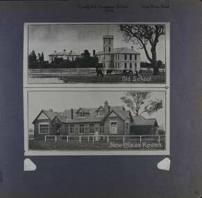
Album - Album page, Caulfield Grammar School, Glen Eira Road, Circa 1972
This photograph is part of the Caulfield Historical Album 1972. This album was created in approximately 1972 as part of a project by the Caulfield Historical Society to assist in identifying buildings worthy of preservation. The album is related to a Survey the Caulfield Historical Society developed in collaboration with the National Trust of Australia (Victoria) and Caulfield City Council to identify historic buildings within the City of Caulfield that warranted the protection of a National Trust Classification. Principal photographer thought to be Trevor Hart, member of Caulfield Historical Society. Most photographs were taken between 1966-1972 with a small number of photographs being older and from unknown sources. All photographs are black and white except where stated, with 386 photographs over 198 pages. In 1881, Reverend J H Davies founded Caulfield Grammar School in Elsternwick, Victoria with just nine students.Page 54 of Photograph Album with one photograph of two images of Caulfield Grammar School. The images are vertically arranged and joining.Hand written: Caulfield Grammar School / 1909 [middle top] / Glen Eira Road [top right ]/ 54 [bottom right]. Top image includes a printed title "Old School" and the bottom image "New Class Rooms".trevor hart, 1880's, 1890's, elsternwick, caulfield grammar school, reverend j h davies, education, glen eira road, st kilda east, church of england, double storey school buildings -
 Glen Eira Historical Society
Album - Album page, St Mary's Church Hall, Glen Eira Road, Circa 1972
This photograph is part of the Caulfield Historical Album 1972. This album was created in approximately 1972 as part of a project by the Caulfield Historical Society to assist in identifying buildings worthy of preservation. The album is related to a Survey the Caulfield Historical Society developed in collaboration with the National Trust of Australia (Victoria) and Caulfield City Council to identify historic buildings within the City of Caulfield that warranted the protection of a National Trust Classification. Principal photographer thought to be Trevor Hart, member of Caulfield Historical Society. Most photographs were taken between 1966-1972 with a small number of photographs being older and from unknown sources. All photographs are black and white except where stated, with 386 photographs over 198 pages. The Jubilee School on the corner of Hood Crescent and Glen Eira Road was built in 1887 AD to commemorate Queen Victoria’s Jubilee.Victorian Heritage Database https://vhd.heritagecouncil.vic.gov.au/places/43705 The former St Mary's Jubilee School is locally significant as an early purpose built church school, associated with St Mary's Church. Its use of polychrome brick is locally conspicuous whilst the adoption of the Gothic Style not only underlines its Christian foundations but relates to the comparable schools of the Public Works Department of the same period.Page 57 of Photograph Album with four exterior photographs (2 portrait and 2 landscape) of St Mary's Church Hall. Bottom right photograph is a photo of a photo.Hand written: St Mary's Church Hall - Glen Eira Road [top left] / Neg 233 8 Oct 1966 [under top left photo] / 3 Sept 1972 [under bottom left photo] / bottom right photo titled "St Mary's Sunday School" / 57 [bottom left] trevor hart, 1880's, elsternwick, glen eira road, st kilda east, church of england, st mary's, caulfield north, st mary's anglican church hall, hood crescent, jubilee school, polychrome brickwork, curved windows, church hall, queen victoria’s jubilee, victorian, sunday schools, st mary's jubilee school, gothic style -
 Glen Eira Historical Society
Album - Album page, Glen Huntly Road, Circa 1972
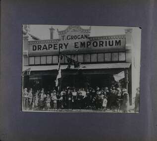
This photograph is part of the Caulfield Historical Album 1972, showing a crowd gathered in front of T Grogan's Drapery Emporium, entitled "6: Opening Day Glen Huntly Road Electric Trams 13.11.12". This album was created in approximately 1972 as part of a project by the Caulfield Historical Society to assist in identifying buildings worthy of preservation. The album is related to a Survey the Caulfield Historical Society developed in collaboration with the National Trust of Australia (Victoria) and Caulfield City Council to identify historic buildings within the City of Caulfield that warranted the protection of a National Trust Classification. Principal photographer thought to be Trevor Hart, member of Caulfield Historical Society. Most photographs were taken between 1966-1972 with a small number of photographs being older and from unknown sources. All photographs are black and white except where stated, with 386 photographs over 198 pages.Page 71 of Photograph Album with one photograph (in portrait) from Glen Huntly Road taken circa 1912. Hand written: 71 [bottom left] // title on photograph " 6: OPENING DAY GLEN HUNTLY ROAD ELECTRIC TRAMS 13.11.12"trevor hart, glen huntly road, elsternwick, shops, electric trams, crowds, buildings, flags, victorian, opening day, celebrations, glenhuntly road, t grogan's drapery emporium, clothing shops, openings (events), t grogan -
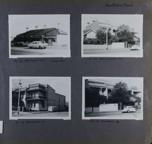 Glen Eira Historical Society
Album - Album page, Hawthorn Road, Circa 1972
This photograph is part of the Caulfield Historical Album 1972. This album was created in approximately 1972 as part of a project by the Caulfield Historical Society to assist in identifying buildings worthy of preservation. The album is related to a Survey the Caulfield Historical Society developed in collaboration with the National Trust of Australia (Victoria) and Caulfield City Council to identify historic buildings within the City of Caulfield that warranted the protection of a National Trust Classification. Principal photographer thought to be Trevor Hart, member of Caulfield Historical Society. Most photographs were taken between 1966-1972 with a small number of photographs being older and from unknown sources. All photographs are black and white except where stated, with 386 photographs over 198 pages. 23-29 Hawthorn Road Caulfield North are contributory buildings to HO14 Caulfield North and environs, Caulfield North - Heritage Precinct in the City of Glen Eira.Page 82 of Photograph Album with four landscape photographs of street views of two sets of properties on Hawthorn Road. Addresses are handwritten underneath each property.Handwritten: Hawthorn Road [top right] / 28-34 HAWTHORN ROAD 3 Sep 1972 [under top left photo] / 23-29 HAWTHORN ROAD [under top right photo] / 23-29 HAWTHORN ROAD 3 Sep [under bottom left photo] / 23-29 HAWTHORN ROAD [under bottom right photo] / 82 [bottom right] trevor hart, caulfield, hawthorn road, victorian, cars, terrace houses, cottages, streetscapes, caulfield north