Showing 3762 items
matching surveyed
-
 Glen Eira Historical Society
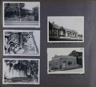
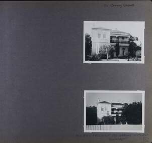
Album - Album page, Hawthorn Road, Circa 1972
This photograph is part of the Caulfield Historical Album 1972. This album was created in approximately 1972 as part of a project by the Caulfield Historical Society to assist in identifying buildings worthy of preservation. The album is related to a Survey the Caulfield Historical Society developed in collaboration with the National Trust of Australia (Victoria) and Caulfield City Council to identify historic buildings within the City of Caulfield that warranted the protection of a National Trust Classification. Principal photographer thought to be Trevor Hart, member of Caulfield Historical Society. Most photographs were taken between 1966-1972 with a small number of photographs being older and from unknown sources. All photographs are black and white except where stated, with 386 photographs over 198 pages. 17 Hawthorn Road, North Caulfield is a contributory building to HO14 Caulfield North and environs, Caulfield North - Heritage Precinct in the City of Glen Eira.Page 83 of Photograph Album with five portrait photographs of 3 different properties on Hawthorn Road. Addresses are handwritten underneath each property.Handwritten: 17 HAWTHORN ROAD [under top left photo] / 17 HAWTHORN ROAD [under middle left photo] / 17 HAWTHORN ROAD [under bottom left photo] / 158-162 HAWTHORN ROAD [under top right photo] // STATE SAVINGS BANK CAULFIELD WEST BRANCH / 144 HAWTHORN RD / WEST SIDE - SOUTH OFF BALACLAVA ROAD [under bottom right photo] / 83 [bottom left] trevor hart, caulfield, hawthorn road, verandahs, houses, shops, banks, state savings bank, caulfield west, caulfield north, tudor style, victorian style -
 Glen Eira Historical Society
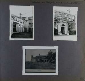
Album - Album page, Helenslea now Shelford CEGGS, Hood Crescent, Circa 1972
This photograph is part of the Caulfield Historical Album 1972. This album was created in approximately 1972 as part of a project by the Caulfield Historical Society to assist in identifying buildings worthy of preservation. The album is related to a Survey the Caulfield Historical Society developed in collaboration with the National Trust of Australia (Victoria) and Caulfield City Council to identify historic buildings within the City of Caulfield that warranted the protection of a National Trust Classification. Principal photographer thought to be Trevor Hart, member of Caulfield Historical Society. Most photographs were taken between 1966-1972 with a small number of photographs being older and from unknown sources. All photographs are black and white except where stated, with 386 photographs over 198 pages. The mansion has been the site of Shelford Church of England Girls’ Grammar School - now Shelford Girls’ Grammar School - since circa 1922.From Victorian Heritage Database citation for HO115: "Helenslea" 3 Hood Crescent, Caulfield North https://vhd.heritagecouncil.vic.gov.au/places/35212 as at 21/10/2020 ''Helenslea'' was built for Sir George Stephen, MLA, barrister and mining investor by 1863. It was built with an address to Glen Eira Road with the driveway gates close by the present Helenslea Road corner. The present address is no. 3 Hood Crescent, Caulfield North. It is historically, aesthetically and socially significant. It is historically significant (Criterion A) as the home of Sir George Stephen, MLA for Collingwood, barrister and mining investor and for its capacity to demonstrate Caulfield's early attraction as a residential retreat for Melbourne's eminent citizens. It is aesthetically significant (Criterion E) as a villa residence characteristic of the mid Victorian period, predating the use of cast iron and comparing in this respect with Charles Webb's "Farleigh" (1865) at 6 Farleigh Grove, Brighton. Its substantial nature causes it to be the earliest surviving mansion house in the Municipality. The porch, external austerity and opulent entrance hall and staircase are important contributory elements whilst the survival of the exterior surfaces predominantly in an unpainted state enhances its level of integrity. It is socially significant (Criterion G) for its association with Shelford C.E.G.G.S. since 1922. Page 86 of Photograph Album with three photographs (two portrait and one landscape ) of different views of Helenslea. One is a photo of a photograph.Handwritten: "Helenslea" now C.E.G.G.S Hood Cres [top right] / third photo is of a photograph titled "Shelford" / 86 [bottom right]trevor hart, hood crescent, helenslea, c.e.g.g.s., school, 1860's, sir george stephen, unpainted, mansion, shelford, villa residence, mid victorian, glen eira road, helenslea road, ceggs, porches, stairs, caulfield north, entrances, shelford church of england girls' grammar school, shelford girl's grammar, ivy -covered walls, caulfield -
 Vision Australia
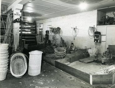
Photograph - Image, Queensland Industrial Institution for the Blind workshops, July 1965
Four images taken of the Queensland Industrial Institute for the Blind by the Survey Office, Dept of Lands. 1 - The basket shop. From left to right: Merv Campbell making a linen basket, Dave Valoniti (?) making a waste paper basket, Phil Woods making a clothes basket and Bill Smith making a wastepaper basket. Examples of finished linen, cot and cane baskets sit to the left of the image. 2- The basket shop on the other side of the building. Unfortunately no individuals have been identified. 3 - Shop foreman Ron Blinco working at a brush making machine. 4-6 - Queensland Industrial Institution for the Blind truck carrying cane baskets, cots, chairs and seat frame. On the door of the truck reads: Health & Home Department. The side of the truck has the following painted on the sideboards: Manufacturers of Baskets, Bedding, Brooms, Brushes, Cane Furniture, Coir Mat & Matting.6 x B/W photographs of men and equipmentC2-5792, C2-5794, C2-5795,C2-5799queensland industrial institute for the blind, merv campbell, dave valoniti, phil woods, bill smith, ron blinco -
 City of Moorabbin Historical Society (Operating the Box Cottage Museum)
Document, Henry Dendy family Shield
In 1840 Henry Dendy, a farmer in Surrey, England acquired a "Special Survey" from the Commissioners for Land and Emigration which gave Dendy the right to choose land in Port Phillip for the "bargain basement" price of only £1 per acre for 5120 acres, (an area of 8 square miles). The Special Survey also included the right to "the shipment of a worker for every £20 spent on land, whose free passage was paid by the Crown, equalling a total of 100 workers ". Accordingly Dendy sold his English holdings and paid the required £5120 and arrived in Melbourne in February 1841. However by this time land in the new colony was selling for £5 - £40 per acre. Because Henry Dendy possessed the order from the Colonial Office in London he was able to successfully oppose Super-intendant LaTrobe's attempts to alter the price of the land. Dendy appointed Jonathan Were, (an entrepreneur, who had arrived in 1839), as his Manager and who later became a partner. Together, Dendy and Were decided on an area 5 miles south from Melbourne, bounded by North Road, East Boundary Road, South Road and to the west by Port Phillip Bay. Were and Dendy pitched their tents in the area now known as ' Park St, Brighton' and sank a well near the corner of 'St Andrew's St and Wells St'. By 1845 J.B Were and Company had bought almost half of Dendy's land and Were built himself "Moorabbin House" in Were St Brighton made from stone, quarried from local cliffs. It was still standing in 1924. Legend records Moorabbin is named after the Aboriginal word for ' Mother's Milk ' The soil is very fertile and well supplied with water especially in the area called 'East Brighton' - now known as Bentleigh and East Bentleigh - By 1850 the area had developed with numerous market gardens, dairy farms, fruit gardens and vineyards supplying food for the growing population of Melbourne. dendy henry, dendy's special survey brighton 1841, governor gipps, captain lonsdale, super-intendant latrobe, port phillip, melbourne, new south wales, squatters, emmigrants, county of bourke, parish of moorabbin, early settlers, pioneers, market gardeners, dairy farmers, fruit farms, moorabbin, bentleigh, brighton, cheltenham, were jonathan binn, -
 Christ Church Anglican Parish of Warrnambool
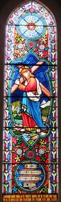
Memorial window: William RUTLEDGE, "BY THY CROSS AND PASSION GOOD LORD DELIVER US""
William Rutledge [born 1806, Ireland] was a self-made, larger-than-life man who involved himself prominently in business, municipal, political, community and social aspects of life. Eldest son of James and Martha [nee Forster], William arrived in Australia from Ireland in 1829 and within six years had sufficiently established himself to purchase land in New South Wales. He married Eliza Kirk in Sydney in august 1840. They had two sons and five daughters. In 1843 he began his association and life in Port Fairy and soon became prominent and influential in almost all aspects of that developing town. His interests encompassed mercantile, civic, pastoral, shipping, importing, exporting, immigration, politics and social aspects with in the district and colony. He was a major contributor to the building of St John’s Anglican Church, Port Fairy. He acquired three special surveys with historical importance in Victoria. In south west Victoria that interest being especially the Farnham Survey of 5120 acres between Dennington and Tower Hill/Killarney. This was farmed by immigrant tenant and lessee farmers, some of whom were brought to the Australia at William Rutledge’s own expense and by whom he was considered a kind and considerate landlord. His endeavours were not without failures and in 1862 his Port Fairy Company failed with debts of over £170,000. This debt was redeemed in full within a year. According to reported accounts, William Rutledge had a tempestuous manner with an “explosive” temper, although he did not hold grudges. This is countered by accounts of his kindness, generosity, honesty and practical, progressive outlook in all his undertakings. After the failure and closure of his Company, William Rutledge moved to his property at Farnham Park near Warrnambool where he concentrated his interest in breeding sheep and horses. Throughout his life his home was reputed to be convivial and hospitable. William Rutledge died at Farnham Park on June 1st, 1876. William Rutledge's place in the history of settlement in south west Victoria gives importance to this memorial.Stained glass window, south wall, main nave, depicting Jesus bearing the Cross. The background is quite floral. A medallion shape holds the title as printed on a ribbon: "By thy cross and passion good Lord deliver us".In Latin: In Memoriam Gulielmi Rutledge qui A.D. MDCCCVI underimo ante Kal: Feb: natus vitam posuit/ Kal: Jun: MDCCCLXXVI Filae amantissimae hanc fenestram pietatis indirio posueruntrutledge, william rutledge, farnham survey, port fairy, christ church warrnambool -
 City of Moorabbin Historical Society (Operating the Box Cottage Museum)
Document - Genealogy Chart Henry Dendy (Photocopy), 19 thC
In 1840 Henry Dendy, a farmer in Surrey, England acquired a "Special Survey" from the Commissioners for Land and Emigration which gave Dendy the right to choose land in Port Phillip for the "bargain basement" price of only £1 per acre for 5120 acres, (an area of 8 square miles). The Special Survey also included the right to "the shipment of a worker for every £20 spent on land, whose free passage was paid by the Crown, equalling a total of 100 workers ". Accordingly Dendy sold his English holdings and paid the required £5120 and arrived in Melbourne in February 1841. However by this time land in the new colony was selling for £5 - £40 per acre. Because Henry Dendy possessed the order from the Colonial Office in London he was able to successfully oppose Super-intendant LaTrobe's attempts to alter the price of the land. Dendy appointed Jonathan Were, (an entrepreneur, who had arrived in 1839), as his Manager and who later became a partner. Together, Dendy and Were decided on an area 5 miles south from Melbourne, bounded by North Road, East Boundary Road, South Road and to the west by Port Phillip Bay. Were and Dendy pitched their tents in the area now known as ' Park St, Brighton' and sank a well near the corner of 'St Andrew's St and Wells St'. By 1845 J.B Were and Company had bought almost half of Dendy's land and Were built himself "Moorabbin House" in Were St Brighton made from stone, quarried from local cliffs. It was still standing in 1924. Legend records Moorabbin is named after the Aboriginal word for ' Mother's Milk ' The soil is very fertile and well supplied with water especially in the area called 'East Brighton' - now known as Bentleigh and East Bentleigh - By 1850 the area had developed with numerous market gardens, dairy farms, fruit gardens and vineyards supplying food for the growing population of Melbourne.In 1840 Henry Dendy, a farmer in Surrey, England acquired a "Special Survey" from the Commissioners for Land and Emigration which gave Dendy the right to choose land in Port Phillip for the price of only £1 per acre for 5120 acres. This land was called Brighton in the Parish of Moorabbin, County of Bourke and emigrants developed the land establishing market gardens , dairy and poultry farms that provided the food for the growing population of Melbourne. A photocopy of the Genealogy Chart of the Dendy Family that Henry Dendy brought with him when he emigrated to Melbourne 1841Genealogy signs and descriptionsdendy henry, dendy's special survey brighton 1841, governor gipps, captain lonsdale, super-intendant latrobe, port phillip, melbourne, new south wales, squatters, emmigrants, county of bourke, parish of moorabbin, early settlers, pioneers, market gardeners, dairy farmers, fruit farms, moorabbin, bentleigh, brighton, cheltenham, were jonathan binn, -
 City of Moorabbin Historical Society (Operating the Box Cottage Museum)
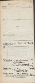
Document - Pedigree of Henry Dendy, c1840 Original ; Copy 1985
This is a copy of the document brought by Henry Dendy to the Colony in 1841. In 1840 Henry Dendy, a farmer in Surrey, England acquired a "Special Survey" from the Commissioners for Land and Emigration which gave Dendy the right to choose land in Port Phillip for the "bargain basement" price of only £1 per acre for 5120 acres, (an area of 8 square miles). The Special Survey also included the right to "the shipment of a worker for every £20 spent on land, whose free passage was paid by the Crown, equalling a total of 100 workers ". Accordingly Dendy sold his English holdings and paid the required £5120 and arrived in Melbourne in February 1841. However by this time land in the new colony was selling for £5 - £40 per acre. Because Henry Dendy possessed the order from the Colonial Office in London he was able to successfully oppose Super-intendant LaTrobe's attempts to alter the price of the land. Dendy appointed Jonathan Were, (an entrepreneur, who had arrived in 1839), as his Manager and who later became a partner. Together, Dendy and Were decided on an area 5 miles south from Melbourne, bounded by North Road, East Boundary Road, South Road and to the west by Port Phillip Bay. Were and Dendy pitched their tents in the area now known as ' Park St, Brighton' and sank a well near the corner of 'St Andrew's St and Wells St'. By 1845 J.B Were and Company had bought almost half of Dendy's land and Were built himself "Moorabbin House" in Were St Brighton made from stone, quarried from local cliffs. It was still standing in 1924. Legend records Moorabbin is named after the Aboriginal word for ' Mother's Milk ' The soil is very fertile and well supplied with water especially in the area called 'East Brighton' - now known as Bentleigh and East Bentleigh - By 1850 the area had developed with numerous market gardens, dairy farms, fruit gardens and vineyards supplying food for the growing population of Melbourne. A copy of a paper chart of the Pedigree of Henry Dendy in a wooden frame with glassPedigree / of the branch of the family / DENDY moorabbin, brighton, henry dend special survey 1841 y, early settlers, pioneers, market gardeners -
 City of Moorabbin Historical Society (Operating the Box Cottage Museum)
Newsletter, City of Moorabbin Historical Society June 2009, June 2009
The City of Moorabbin Historical Society was formed c 1960 by a group of Moorabbin residents who were concerned that the history of the area should be preserved. A good response to a call for items related to the historical area of Moorabbin Shire brought donations of a wide variety of artefacts which are now preserved by the current members of CMHS at Box Cottage Museum . Helen Stanley, Secretary of CMHS, began producing a Newsletter for members in April 2007 to provide current information and well researched items of historical interest.Helen Stanley has produced a bi-monthly Newsletter, 2007 - 2013, for the members of the City of Moorabbin Historical Society that contains well researched interesting historical items, notification of upcoming events, current advice from Royal Australian Historical Society , Museums Australia Victoria and activities of Local Historical Societies. The Newsletter is an important record of the activities of the CMHS. Jasper Hale , transported for theft, earned his ‘Ticket of Leave, and purchased land in Dendy’s Special Survey of 1841 later known as East Bentleigh. 2 x A4 paper printed on 3 sides Issue 12 of the bi-monthly, City of Moorabbin Historical Society Newsletter produced by Society member and Secretary, Mrs Helen Stanley in June 2009. Notices of the meeting June 28th , an article in ‘The Leader’ newspaper about the Robert Keys ‘Best Fruit Garden 1881 - 82’ Trophy Cup , a large vinyl banner purchased with Grant money, and while acknowledging the Cottage garden volunteer a request for more helpers at Open Days is made. Jan Rigby, CMHS member, has provided research information about Jasper Hale b 1805 in Gloucester, England, transported to NSW 1830, ‘freed man ‘ 1839, purchased land in Dendy’s Special Survey 1844, sold this land 1846 and died 1884 in Parkes NSW. On arrival as a convict in 1830 his occupation is bricklayer and he can ‘ read and write’. CITY of MOORABBIN HISTORICAL SOCIETY / JUNE 2009 NEWSLETTERcity of moorabbin historical society, stanley helen, rigby jan, melbourne, moorabbin, brighton, cheltenham, ormond, bentleigh, market gardeners, pioneers, early settlers, moorabbin shire, box cottage museum, jasper road ormond, dendy’s special survey 1851, north road brighton, county of bourke, box h., box william, parish of moorabbin, were jonathan, hales jasper, port jackson penal colony, burgess s. william, kemble wiltshire england, stonemason, bricklayer, ‘york’ sailing ship, brummell mary, st. mary’s catholic church sydney, nelson mary ann, ‘george hibbert’ sailing ship, hale james, hale eliza, parkes new south wales gold rush, ballarat gold rush, clunes gold rush, forbes nsw gold rush, parkes historical society -
 Kew Historical Society Inc
Plan, Melbourne & Metropolitan Board of Works : Borough of Kew : Detail Plan No.1302, 1910
The Melbourne and Metropolitan Board of Works (MMBW) plans were produced from the 1890s to the 1950s. They were crucial to the design and development of Melbourne's sewerage and drainage system. The plans, at a scale of 40 feet to 1 inch (1:480), provide a detailed historical record of Melbourne streetscapes and environmental features. Each plan covers one or two street blocks (roughly six streets), showing details of buildings, including garden layouts and ownership boundaries, and features such as laneways, drains, bridges, parks, municipal boundaries and other prominent landmarks as they existed at the time each plan was produced. (Source: State Library of Victoria)This plan forms part of a large group of MMBW plans and maps that was donated to the Society by the Mr Poulter, City Engineer of the City of Kew in 1989. Within this collection, thirty-five hand-coloured plans, backed with linen, are of statewide significance as they include annotations that provide details of construction materials used in buildings in the first decade of the 20th century as well as additional information about land ownership and usage. The copies in the Public Record Office Victoria and the State Library of Victoria are monochrome versions which do not denote building materials so that the maps in this collection are invaluable and unique tools for researchers and heritage consultants. A number of the plans are not held in the collection of the State Library of Victoria so they have the additional attribute of rarity.Original survey plan, issued by the MMBW to a contractor with responsibility for constructing sewers in the area identified on the plan within the Borough of Kew. The plan was at some stage hand-coloured, possibly by the contractor, but more likely by officers working in the Engineering Department of the Borough and later Town, then City of Kew. The hand-coloured sections of buildings on the plan were used to denote masonry or brick constructions (pink), weatherboard constructions (yellow), and public buildings (grey). The absence of buildings and or property in Kew facing the Yarra is the most notable feature of this plan. Walmer Street and its bridge stretched, then and now, from Studley Park Road to Victoria Street, Richmond. On the Richmond side of the Yarra, there was evidence in 1904 of industry (‘Wool shed’; Soap Works’) and entertainment (‘Skittle Alley’). In reality, another Plan (No.1303) shows Chinese Gardens bordering the Yarra on the Kew side and buildings in Young Street.melbourne and metropolitan board of works, detail plans, mmbw 1302, cartography -
 Kew Historical Society Inc
Plan, Melbourne & Metropolitan Board of Works : Borough of Kew : Detail Plan No.1571, 1904
The Melbourne and Metropolitan Board of Works (MMBW) plans were produced from the 1890s to the 1950s. They were crucial to the design and development of Melbourne's sewerage and drainage system. The plans, at a scale of 40 feet to 1 inch (1:480), provide a detailed historical record of Melbourne streetscapes and environmental features. Each plan covers one or two street blocks (roughly six streets), showing details of buildings, including garden layouts and ownership boundaries, and features such as laneways, drains, bridges, parks, municipal boundaries and other prominent landmarks as they existed at the time each plan was produced. (Source: State Library of Victoria)This plan forms part of a large group of MMBW plans and maps that was donated to the Society by the Mr Poulter, City Engineer of the City of Kew in 1989. Within this collection, thirty-five hand-coloured plans, backed with linen, are of statewide significance as they include annotations that provide details of construction materials used in buildings in the first decade of the 20th century as well as additional information about land ownership and usage. The copies in the Public Record Office Victoria and the State Library of Victoria are monochrome versions which do not denote building materials so that the maps in this collection are invaluable and unique tools for researchers and heritage consultants. A number of the plans are not held in the collection of the State Library of Victoria so they have the additional attribute of rarity.Original survey plan, issued by the MMBW to a contractor with responsibility for constructing sewers in the area identified on the plan within the Borough of Kew. The plan was at some stage hand-coloured, possibly by the contractor, but more likely by officers working in the Engineering Department of the Borough and later Town, then City of Kew. The hand-coloured sections of buildings on the plan were used to denote masonry or brick constructions (pink), weatherboard constructions (yellow), and public buildings (grey). This plan is the other half of Plan No.1571 representing the constructions to the west of Wellington Street before and in 1903/4. This plan represents the built environment in Edgevale Road, Wellington Street, Atkins Street, Annadale Street, Mortimer Street, and Cotham Road. Whereas there are smaller allotments and more modest housing stock facing Edgevale Road, larger blocks and more substantial houses are represented facing Cotham Road.melbourne and metropolitan board of works, detail plans, mmbw 1571, cartography -
 Kew Historical Society Inc
Plan, Melbourne & Metropolitan Board of Works : Borough of Kew : Detail Plan No.1575, 1905
The Melbourne and Metropolitan Board of Works (MMBW) plans were produced from the 1890s to the 1950s. They were crucial to the design and development of Melbourne's sewerage and drainage system. The plans, at a scale of 40 feet to 1 inch (1:480), provide a detailed historical record of Melbourne streetscapes and environmental features. Each plan covers one or two street blocks (roughly six streets), showing details of buildings, including garden layouts and ownership boundaries, and features such as laneways, drains, bridges, parks, municipal boundaries and other prominent landmarks as they existed at the time each plan was produced. (Source: State Library of Victoria)This plan forms part of a large group of MMBW plans and maps that was donated to the Society by the Mr Poulter, City Engineer of the City of Kew in 1989. Within this collection, thirty-five hand-coloured plans, backed with linen, are of statewide significance as they include annotations that provide details of construction materials used in buildings in the first decade of the 20th century as well as additional information about land ownership and usage. The copies in the Public Record Office Victoria and the State Library of Victoria are monochrome versions which do not denote building materials so that the maps in this collection are invaluable and unique tools for researchers and heritage consultants. A number of the plans are not held in the collection of the State Library of Victoria so they have the additional attribute of rarity.Original survey plan, issued by the MMBW to a contractor with responsibility for constructing sewers in the area identified on the plan within the Borough of Kew. The plan was at some stage hand-coloured, possibly by the contractor, but more likely by officers working in the Engineering Department of the Borough and later Town, then City of Kew. The hand-coloured sections of buildings on the plan were used to denote masonry or brick constructions (pink), weatherboard constructions (yellow), and public buildings (grey). Plan No.1575 shows that in the area bounded by Wellington Street, Edgevale Road, Glenferrie Road, and Cotham Road, there had already been significant subdivision of land and houses constructed. As one of the highest points in Kew, as expected, there were already some significant mansions built on large allotments of land. Many of these mansions are identified by name on the plan such as ‘Kelso’, ‘Abbotsford’, ‘Clarendon’ and ‘Ashlyn’ in Cotham Road. Other houses of equal size are unnamed on the plan.melbourne and metropolitan board of works, detail plans, maps - borough of kew, mmbw 1575, cartography -
 Bendigo Historical Society Inc.
Document - H.A. & S.R. WILKINSON COLLECTION: CONTRACT OF SALE
Contract of sale of land dated 24th March 1954 between Mr. E.T. Fennell (seller) and Mr. L. Riddell (buyer) for that land situate Jackass Flat being described in right to occupy residence area right No. 0251, together with weatherboard dwelling and all sundry. Price 525 pounds. Also attached receipt no.81247, dated 13 April, 1954 from the department of Crown Lands and Survey, also a letter to Messrs T.M. Williams , Watson, James, Solicitors, Bull Street Bendigo dated 26 March, 1954 signed by Mr.. Fennell instructing to pay from the proceeds of sale of property, Grassy Flat, the sum of 400 pounds to Messrs H.A. & S.R. Wilkinson of 182 Mitchell Street, Bendigo as deposit on purchase of Mr. A.L. Stuckenschmidt's property Raglan Street, White Hills.organization, business, h.a. & s.r wilkinson real estate -
Bendigo Historical Society Inc.
Map - PLAN GENERAL SURVEY MALMSBURY PORCUPINE INN, FOREST CREEK TO GOLDEN POINT. ALEXANDRA RANGE 1853
Colour Copy of Plan of the General Survey from the Town of Malmsbury to the Porcupine Inn, from the sources of Forest Creek to Golden Point, shewing (sic) the Alexandrian Range also Sawpit Gully Bendigo and Bullock Creeks. Handwritten note under the title a follows '' Forwarded to the Colonial Secretary with my letter No A 53/105 dated 30th March 1853 for transmission to the Geological Surveyor. R Hoddle Surveyor General. ' Stamped by Department of Mines Victoria with record#123 in Top right Hand corner. Also contains a catalogue number 2053/M/2. Part of the Contents of a DVD entitled 'Mapping Great Change' - Archival Maps, produced to support an exhibition in the Post Office Gallery Bendigo. A description of the Map, its history and implications for both historical and future discussions is contained in an Essay 'Mapping Great Changes' : The landscape of central Victoria by Gerry Gill.R. Hoddlemap, bendigo, country lands -
Bendigo Historical Society Inc.
Document - DRAINAGE PROBLEMS - VICTORIA QUARTZ DRAINAGE PROBLEMS
Handwritten notes from the Bendigo Advertiser 5/7/1910 Page 3. 'New Chum Mines. Yesterday, Mr H. V. Whetelaw, officer in charge of the local survey branch, Mines Dep't accompanied by Inspector Ross, made their first inspection. Water has reached the 3224 ft. level. Now 1530 feet of water in shaft, including the workings below the 3324 ft. level. Bailing been carried on at the Victoria Quartz, Lansell's 180, 222, and New Chum Consolidated. It will take a week or more to get the Lazarus plant in readiness. Then the shaft will have to examined. At Lansell's 222, the water is 18 ft. below the No 18 level, New Chum Consolidated - 18 ft. below, the 1910 ft. Plat.' Bendigo Advertiser- New Chum Mines - 5/7/1910 Page 3.document, gold, drainage problems, new chum drainage association, victoria quartz drainage problems, bendigo advertiser 5/7/1910 page 3, mr h v whitelaw, mines dept, inspector ross, victoria quartz, lansell's 180, 222, new chum consolidated, lazarus -
 City of Moorabbin Historical Society (Operating the Box Cottage Museum)
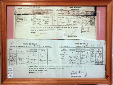
Document, Death Certificate William Box 1902, 1985
William Box1834-1902 and Elizabeth Avis Box 1835-1913 came to Australia with his parents George and Mary Cripps-Box and siblings in 1856. Caroline Box, the eldest daughter of George and Mary Cripps-Box, remained in England working as a cook until she joined the family in Australia in 1863. William Box with his wife Elizabeth Avis Box at first leased market garden allotments in Brighton that was part of the Henry Dendy Special Survey 1841. In 1868 and 1869 they purchased 2 blocks with a pioneer’s cottage in Jasper Road East Brighton ( now Ormond / McKinnon ) where they established a market garden, built a 2nd house and raised 13 children. In 1908 Elizabeth sold most of the land retaining 1 acre with the dwellings in which she resided with her two daughters until her death 1913. The original pioneer cottage was reconstructed in 1984 and is known as Box Cottage Museum William & Elizabeth Avis- Box settled in the pioneer Cottage in Jasper Road East Brighton 1868 and established a market garden whilst raising their 13 children. This Cottage was reconstructed in Joyce Park, Ormond 1984 and is the home of City of Moorabbin Historical Society. In 1960 many local residents responded to a call for the donation of historical artefacts and the Box Cottage Museum now preserves this eclectic collection for the community. A certified true copy of the Death Certificate of William Box 1834 -1902 in a wooden picture frame, obtained from The Births, Deaths and Marriages Office Melbourne Victoria 1985 THIRD SCHEDULE / DEATHS in the District of East Brighton in the State of Victoria Registered by W. Ward Certified ‘true copy of an entry in a register’……… Signed by Paul Kenny Registration Officer 1985 box william, box elizabeth, brighton, moorabbin, cottages, pioneers, ormond, colonial, mckinnon, dendy henry, museums, box alonzo, market gardeners, box cottage museum -
 Kiewa Valley Historical Society
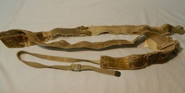
Seal Skins Ski Straps / Soles, mid 1900's
These seal skin straps and webbing were introduced into the Victorian Alps by European engineers, conducting survey work for the SEC Hydro scheme in the late 1930s. This period in time produced many immigrants from a war torn Europe with highly developed technical skills. Many of these immigrants provided articles that were well suited to the alpine regions of Australia, ones they used in their homelands. These were times when the home grown cultures of the Anglo Saxon heritage of the earlier settlers within the Kiewa Valley became interwoven with the various European cultures and this formed, what in later years became the beginning of the Australian multi-cultural society. The Kiewa Valley and its surrounding regions where the major rural areas which did not progress in a so typical Aussie "dinky-di", "she'll be right" fashion. The European influence was however not too strong, so as to obliterate the flavour of the home grown rural society.The major populated sections of the upper Kiewa Valley and the Alpine regions were accelerated by the SEC Hydro Development which brought into the slow growing rural regions a quasi multi ethnic society, however this was only noticeable up to the time when the final Power Station was commissioned in the 1960s. The slight variations to the typical Australian rural settlements of the time were in some food preparations, winter apparel such as these seal skin straps and soles and "langlauf" (cross-country skis). The sealskins were sewn so that their grain ran from front to back thereby allowing the skins to grip going up hill and glide going downhill.The gardens and varieties of flowering shrubs and trees where also more in line with traditional European "outdoor" settings. Seal skin sewn onto one side of a strap of webbing. There is a webbing loop on the front that slips over a small point at the front of the ski. There is a webbing strap attached to the back of the seal skin sole coming over the back of ski that clips metal fasteners onto a loop of webbing behind the ski boot. alpine sports, snow skis, winter clothing, mount bogong recreational activities, snow sports -
 Warrnambool and District Historical Society Inc.
Ledger, Letters on Suspension Bridges, 1890s
This book contains information on the building of suspension bridges and dates from the 1890s. It belonged to John William Crawley Junior, an engineer, surveyor and architect in private practice in Warrnambool and also the engineer for the Shire of Warrnambool from 1895 to 1935. The information in the book comes in the form of lectures on suspension bridge making and these were sent to John Crawley by his tutor or coach, Arnold Lilley (Lilly). Arnold Lilley was an Oxford mathematician working in Victoria and it is said that he coached or trained 95% of the municipal surveyors in Victoria in the 1890s. John Crawley has obviously had this material bound into a book and it was passed on to his son, Rolf, who was the engineer for the Shire of Warrnambool from 1935 to 1968. It then came into the possession of Michael Hand who took over the private surveying business of Rolf Crawley in Warrnambool. The Warrnambool and District Historical Society acquired the book, along with several Crawley ledgers and letter books, from the estate of Michael Hand. This book is of interest as it contains lectures and other material on the building of suspension bridges and belonged to John William Crawley Junior, an engineer for the Shire of Warrnambool for 40 years. It also is a memento of the work of Arnold Lilley who produced the material on suspension bridges and coached John Crawley in his surveying studies.This is a hard cover book with a purple cover. The cover is slightly faded. The book contains handwritten material regarding the building of suspension bridges and includes sketches, lectures on suspension bridges and pages with postage stamps on them. There are three loose pages. ‘’Letters on Suspension Bridges Arnold Lilly Esq. Coach J Wm. Crawley Pupil’john william crawley junior, warrnambool, rolf crawley, warrnambool, shire of warrnambool, arnold lilley, teacher of surveying. -
 Warrnambool and District Historical Society Inc.
Letter book, 1933
This letter book contains letters that date from 1933 to 1936. It came originally from the office of John William Crawley Junior, an engineer, architect and surveyor in private practice in Warrnambool and also the engineer for the Shire of Warrnambool from 1895 to 1935. His father, brother and son were all engineers and worked in that capacity or as the Shire Secretary, for the Shire of Warrnambool, with the Crawley family recording a total of 132 years of service to the Shire. The Shire of Warrnambool existed from 1863 to 1994. The letter book was also used by John Crawley’s son, Rolf who took over the job of engineer at the Shire of Warrnambool in 1935 and held the position until 1968. The book then came into the possession of Michael Hand who took over the private surveying practice of Rolf Crawley in Warrnambool. The Warrnambool and District Historical Society acquired the letter book, along with several other Crawley ledgers, from the Michael Hand Estate. This letter book is of considerable importance as it contains letters written by John Crawley Junior and Rolf Crawley, both engineers for the Shire of Warrnambool over the years covered by the letter book. It will be very useful to researchers. This is a hard cover book of 1000 pages. Only half of the pages have been used and there are some loose sheets. The book is bound on the cover corners and on the spine with buff-coloured leather. The pages contain an alphabetical index and handwritten letters. Some pages are water-stained. ‘Letter Book 1933 Shire’john william crawley, warrnambool, rolf crawley, warrnambool, shire of warrnambool -
 Warrnambool and District Historical Society Inc.
Letter book, J & R Crawley, 1934
This letter book contains letters, sketch maps and plans and dates from1934 to 1936. It originally came from the office of John William Crawley Junior, an engineer, surveyor and architect in private practice in Warrnambool and also the Shire Engineer for the Shire of Warrnambool from 1895 to 1935. His father, brother and son were also engineers and worked in that capacity or as the Shire Secretary for the Shire of Warrnambool, with the Crawley family recording a total of 132 years of service to the Shire. The Shire of Warrnambool existed from 1863 to 1994. The letter book was also used in the private practice of John Crawley’s son, Rolf who was the engineer for the Shire of Warrnambool from 1935 to 1968. The letter book then came into the possession of Michael Hand who took over the private surveying business of Rolf Crawley in Warrnambool. The Warrnambool and District Historical Society acquired the letter book, along with several other Crawley ledgers, from the estate of Michael Hand.This letter book is of considerable significance as it contains letters written by John Crawley and Rolf Crawley who were in an engineering, surveying and architects private practice in Warrnambool over the time covered in the book. It will be very useful to researchers. This is a hard cover book of 1000 pages but only 354 pages have been used. The cover is bound at the corners and on the spine with buff-coloured leather. The book contains an alphabetical index, handwritten letters, sketch maps and plans. ‘Private Letter Book 1934- 19.’ ‘R.L./J. W. Crawley Private’ john william crawley junior, warrnambool, rolf crawley, warrnambool, shire of warrnambool -
 Wangaratta RSL Sub Branch
Cane Woven Basket Tray, The Invasion of the Philippines, c1945
In early January 1945, Australian warships took part in their next big naval action of the campaign when American forces were landed at Lingayen Gulf for the invasion of Luzon Island. Their objective was the capital, Manila. The frigates Gascoyne and Warrego carried out survey tasks and escort duties, coming under artillery fire and also attacks from aircraft. The Kanimbla, Manoora and Westralia again transported American troops for the landings and once again the escorts included the cruisers Shropshire and Australia – the latter had undergone repair – and the destroyers Arunta and Warramunga. Whist not confirmed, this large cane woven oval tray with The Philippines Coat of Arms in the centre above list of Royal Australian Navy ships that were involved in the liberation of the Philippines, is believed to have belonged to Robert Hamilton Hutchieson PM 4802 who served on HMAS Westralia as a landing craft coxswain in the Southwest Pacific Campaign 1942 to 1945. Large oval shaped cane woven basket tray The Invasion of the Philippines Image of Coat of Arms Commonwealth of the Philippines Kanimbla, Westralia, Manoura, Australia, Shropshire, Arunta, Warramunga, Gascoyne January 1945ww2, invasion of the philippines, 1945, hmas westralia, hmas kanimbla -
Federation University Historical Collection
Booklet, W. B. Macdonald, The Ballarat School of Mines, Industries and Science, Annual Report 1890, 1890
The Ballarat School of Mines Annual Report 1890. Annual Report, Crown Grant, Affiliation Statute, Constitution, Examination Statutes, Associateship of The School, Department of Agriculture, Certificates Granted by Council, Fees, Form of Bequest, Gauge-Testing Apparatus, General Balance Sheet and Liabilities and Assets, Honorary Correspondents, Life Governors, Meteorological Observations, Number of Students attended The School of Mines, Office Bearers, Report of the Professor of Mineralogy and Geology and Curator of the Museum, Report of the Superintendent of Laboratories, Report of the Lecturer on Engineering and Surveying, Report of the Lecturer on Geometrical and Freehand Drawing, Report of the Lecturer on Telegraphy, Report of the Lecturer on Botany, Report of the Lecturer on Materia Medica and Physiology, Report of University Classes, Examinations Held, Scale of Charges for Assays and Analyses, Statement of Receipts and Expenditure for the year 1890 and Special Trust Funds, Statistics - Students attending Lectures, Subjects and Examiners, Subscriptions and Donations from 1st January to 31st December 1890, Time TableThe Ballarat School of Mines annual Report, 1890. Cover is browning around the edges, back cover partly detached and is torn, 184 pages. ballarat school of mines, annual report, andrew anderson j.p. - president (acting) and vice president, rivett henry bland - trustee, the hon. sir w. j. clarke - trustee, the hon. john warrington rogers - trustee, james oddie - trustee, the hon. henry cuthbert - honorary solicitor, i. j. jones - honorary treasurer, chas. kent - auditor, andrew berry - registrar, f. m. krause - professor of mineralogy and geology, and curator of the museum, alf. mica. smith - superintendent of laboratories, mr e. wattis - manager, mining laboratory, j. h. horwood - lecturer on engineering and surveyin, h. j. hall - lecturer geometrical and free-hand drawing, george day - botany, j. f. usher - materia medica and physiology, miss bella guerin - university classes, charles kent - auditor, henry krone - assistant registrar of titles, henry b. loch, d. e. martin - secretary for agriculture, r. hedger wallace - department of agriculture -
Warrnambool and District Historical Society Inc.
Correspondence (Rose Park), 1940s
These are four letters and a document regarding the proposal in the 1940s by the Victorian Department of Lands and Survey to acquire sections of the property, Rose Park, to establish several Soldier Settlement farms. Rose Park, near Willatook, was owned by Stan Baulch (1897-1980), the son of Samuel and Eliza Baulch. Samuel Baulch had acquired the property of Dunmore, between Macarthur and Hawkesdale, in 1893 and Stan had inherited portion of this property after his father’s death. He named his portion Rose Park. The Soldier Settlement Commission wanted to acquire 1500 acres of Rose Park but Stan Baulch argued successfully that the management of his farm could not withstand the loss of so much land and eventually 300 acres of Rose Park land was sold for closer settlement. Stan Baulch was a prominent member of the Warrnambool and District Historical Society for many years and contributed many articles and booklets on local historical matters. This correspondence is of interest as an example of the establishment of Soldier Settlement farms in Victoria post World War Two and the difficulties faced by some property owners opposed to the acquisition of their land. These items will be useful for research. .1 A six-page letter written in pencil .2 A two page letter in black typing ( contents as in .1 above) .3 A one page letter, typed, with a handwritten signature .4 A sheet of paper containing a statement re purchase of land with some inserted handwritten material .5 A two page letter with handwritten material baulch family, western district, victoria, history of warrnambool -
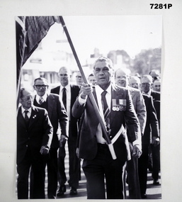 Bendigo Military Museum
Photograph - PHOTOGRAPH, ANZAC DAY 1985, Bendigo Advertiser, C. 25.4.1985
The photo was taken on ANZAC Day 1985 at the Kangaroo Flat RSL service with Bill Forrest leading. William (Bill) Malcolm Forrest was born in Moora WA, enlisted 12.4.1951 No 5/1788 age 18 years and became a Sapper. After attending Battle School in Japan he then served with 3 RAR in Korea, DVA file states 12.7.1953 to 15.7.1954. He later went on to serve with 2 RAR in Malaya. He was discharged after 6 years service on 11.4.1957, discharge certificate states Active Service being 1 year 337 days. He re enlisted again on 11 3.1958 with Regt No 36283 and served another 17 years 165 days and was discharged with the rank of Sgt on 22.8.1975. During this engagement he had Corps and Trade Training 6 months, Regimental, Steward, Army Mess Supervisor and General Duties with Training and Survey Units.Photograph B & W showing a group of men marching in an ANZAC Day Parade. The man leading carrying a flag is Bill Forrest from Kangaroo Flat RSL.photographs, anzac day, korea, malaya -
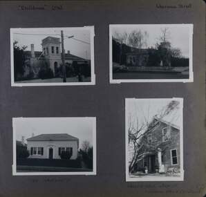 Glen Eira Historical Society
Album - Album page, Ercildoune (576), Inkerman Street, Circa 1972
This photograph is part of the Caulfield Historical Album 1972. This album was created in approximately 1972 as part of a project by the Caulfield Historical Society to assist in identifying buildings worthy of preservation. The album is related to a Survey the Caulfield Historical Society developed in collaboration with the National Trust of Australia (Victoria) and Caulfield City Council to identify historic buildings within the City of Caulfield that warranted the protection of a National Trust Classification. Principal photographer thought to be Trevor Hart, member of Caulfield Historical Society. Most photographs were taken between 1966-1972 with a small number of photographs being older and from unknown sources. All photographs are black and white except where stated, with 386 photographs over 198 pages. Vol 1 Caulfield's Building Heritage by Dr Geulah Solomon states that Ercildoune was the home of Sir Samuel Wilson and later, Arthur Knox. Knox is likely the person who subdivided the land, creating Ercildoune Street.Page 100 of Photograph Album with two photographs (landscape) of Ercildoune and two photographs (one landscape and one portrait) of two other houses on Inkerman Street.Handwritten: "Ercildoune" (576) [top left] / Inkerman Street [top right] / 138 INKERMAN ST [under bottom left photo] / LABASSA GROVE CORNER OF INKERMAN OPPOSITE ERCILDOUNE [under bottom right photo] / 100 [bottom right]trevor hart, east st kilda, ercildoune, mansions, towers, gardens, bloomsbury, inkerman road, labassa grove, attic houses, porches, inkerman street, caulfield north, st kilda east, sir samuel wilson, arthur knox, ercildoune street, house names -
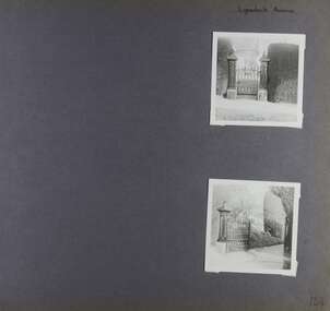 Glen Eira Historical Society
Album - Album page, Lynedoch Avenue, Circa 1972
This photograph is part of the Caulfield Historical Album 1972. This album was created in approximately 1972 as part of a project by the Caulfield Historical Society to assist in identifying buildings worthy of preservation. The album is related to a Survey the Caulfield Historical Society developed in collaboration with the National Trust of Australia (Victoria) and Caulfield City Council to identify historic buildings within the City of Caulfield that warranted the protection of a National Trust Classification. Principal photographer thought to be Trevor Hart, member of Caulfield Historical Society. Most photographs were taken between 1966-1972 with a small number of photographs being older and from unknown sources. All photographs are black and white except where stated, with 386 photographs over 198 pages. National Trust - 9 Lynedoch Avenue, CAULFIELD NORTH VIC 3161 - Property No B3310 https://vhd.heritagecouncil.vic.gov.au/places/65663 - this record is just one photo with no text; the photo is almost identical to the photograph of the smaller gate on this album page. Page 124 of Photograph Album with two square photographs of gates.Handwritten: Lynedoch Avenue [top right] / 124 [bottom right]trevor hart, gates, cast iron gate, caulfield north, gate, hedge, cast iron spears, stone plinths, masonry column, masonry pillar, lynedoch avenue, st kilda east -
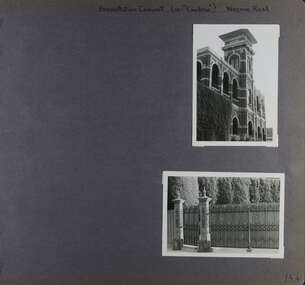 Glen Eira Historical Society
Album - Album page, Presentation Convent (ex "Cambria), Neerim Road, Circa 1972
This photograph is part of the Caulfield Historical Album 1972. This album was created in approximately 1972 as part of a project by the Caulfield Historical Society to assist in identifying buildings worthy of preservation. The album is related to a Survey the Caulfield Historical Society developed in collaboration with the National Trust of Australia (Victoria) and Caulfield City Council to identify historic buildings within the City of Caulfield that warranted the protection of a National Trust Classification. Principal photographer thought to be Trevor Hart, member of Caulfield Historical Society. Most photographs were taken between 1966-1972 with a small number of photographs being older and from unknown sources. All photographs are black and white except where stated, with 386 photographs over 198 pages. References cited above indicate that Cambria was demolished around 1974-1976 (2 dates given). Caulfield's Built Heritage states it was built for Cyril Godby with the National Trust (Victorian Heritage Database) saying it was built in 1888.Page 144 of Photograph Album with two photographs (one portrait, one landscape) of Presentation Convent, Neerim Road.Handwritten: Presentation Convent (ex- "Cambria") Neerim Road [top] / 144 [bottom right]trevor hart, presentation sisters, cambria, presentation convent, roseberry grove, glen huntly, neerim road, convent, victorian, polychrome bricks, mansions, gates, verandahs, balconies, towers, lookouts, cyril godby, house names -
 Glen Eira Historical Society
Album - Album page, 84 Orrong Crescent, Circa 1972
This photograph is part of the Caulfield Historical Album 1972. This album was created in approximately 1972 as part of a project by the Caulfield Historical Society to assist in identifying buildings worthy of preservation. The album is related to a Survey the Caulfield Historical Society developed in collaboration with the National Trust of Australia (Victoria) and Caulfield City Council to identify historic buildings within the City of Caulfield that warranted the protection of a National Trust Classification. Principal photographer thought to be Trevor Hart, member of Caulfield Historical Society. Most photographs were taken between 1966-1972 with a small number of photographs being older and from unknown sources. All photographs are black and white except where stated, with 386 photographs over 198 pages. From Victorian Heritage Database citation for 84 Orrong Crescent https://vhd.heritagecouncil.vic.gov.au/places/35584 as at (28/10/2020) "St. Reliers" at 84 Orrong Crescent is important as an unusually excessively enriched asymmetrical villa residence of the Boom period. From Victorian Heritage Database citation for HO50 84 Orrong Crescent Caulfield North https://vhd.heritagecouncil.vic.gov.au/places/35584 as at (28/10/2020) An imposing Italianate two storeyed asymmetrical villa with overpainted stuccoed surfaces to the facade, distinguished by their ornate treatment. Unusually rich ornamentation includes the acanthus leaf impost capitals, aedicules with swags and volutes, foliated panels to the frieze, ashlar treatment to the lower level and quoins above. The two storeyed cast iron verandah with timber frieze rail protects a black and white tiled floor. The hipped roof has patterned slates.Page 152 of Photograph Album with two landscape photographs of Bonhurst on Orrong Crescent.Handwritten: 84 Orrong Crescent [top right] / NOW 84 - PREVIOUSLY 120 ORRONG CRESCENT / "BONHURST" [under bottom photo] / 152 [bottom right]trevor hart, verandah, porch, slate roof, garden, decorative brackets, fanlight, protruding bay, bay window, garden lamp, asymmetrical, bonhurst, st reliers, rendered, orrong crescent, caulfield north, cast iron work, victorian style, mansions, house names, slate roofs, italianate style -
 Glen Eira Historical Society
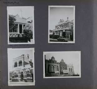
Album - Album page, Glen Huntly Road, Circa 1972
This photograph is part of the Caulfield Historical Album 1972. This album was created in approximately 1972 as part of a project by the Caulfield Historical Society to assist in identifying buildings worthy of preservation. The album is related to a Survey the Caulfield Historical Society developed in collaboration with the National Trust of Australia (Victoria) and Caulfield City Council to identify historic buildings within the City of Caulfield that warranted the protection of a National Trust Classification. Principal photographer thought to be Trevor Hart, member of Caulfield Historical Society. Most photographs were taken between 1966-1972 with a small number of photographs being older and from unknown sources. All photographs are black and white except where stated, with 386 photographs over 198 pages. The Former Elsternwick Post Office is on the Victorian Heritage Register H0640 with a full significance statement and also HO29 with the City of Glen Eira. Much of the Glen Huntly Road heritage retail strip is heritage listed in HO72 with the City of Glen Eira.Page 67 of Photograph Album with four photographs (three portrait and one landscape) of different properties on Glen Huntly Road - a house, Post Office, ANZ Bank and shops.Hand written: Glen Huntly Road [top left] / 1027 GLEN HUNTLY RD [under top left photo] / ELSTERNWICK POST OFFICE [under top right photo] / 67 [bottom left] trevor hart, glen huntly road, elsternwick, shops, caulfield, post offices, glenhuntly road, banks, brick houses, shopping centres -
 Wodonga & District Historical Society Inc
Map - Tulloch & Brown's Map of the Colony of Victoria, Tulloch & Brown, 1856
The map was created by Tulloch and Brown. David Tulloch was one of the earliest engravers and lithographers in the state of Victoria. He arrived in Melbourne from Greenock, Scotland, on 3 January 1849. Following the discovery of gold Tulloch went to the Victorian goldfields in 1851, commissioned to make sketches of the diggers and the diggings for Ham’s Illustrated Australian Magazine. In November 1852 Tulloch set up in business as engraver, draughtsman, copperplate printer and lithographer. Tulloch took a map engraver, James Davie Brown, into partnership in March 1853; the several maps and specimens of commercial engraving they showed at the 1854 Melbourne Exhibition were awarded a bronze medal. That year Tulloch and Brown also received a silver medal at the Victorian Industrial Exhibition. The partnership was dissolved towards the end of 1856.This is a very early map of the Colony of Victoria including Belvoir (now know as Wodonga).A foldable map mounted on linen and with a board cover. It records the Colony of Victoria according to Surveyor's Records revised in 1857. Areas of the map are shaded to highlight different counties.At bottom right hand section of map: Tulloch & Brown's map of the Colony of Victoria : comprising part of New South Wales, the boundaries, counties, also seaport & inland townships, the gold fields with the latest discoveries, roads, tracks, &c. &c. / compiled from drawings in the Survey Office and correctly revised till 1857. Respectfully dedicated by Permission, to the Honorable Captain Andrew Clarke R.E. Surveyor General of Victoria by His Obediant Servants Tulloch & Brown, Engravers & Publishers, Melbourne". At bottom right below border : Published as the Act directs by the Proprietors, Melbourne, 1st Feb. 1856. tulloch and brown maps, rare maps victoria, victorian cartography -
 Kew Historical Society Inc
Plan, Melbourne and Metropolitan Board of Works, Borough of Kew : Detail Plan No.1562, 1905
The Melbourne and Metropolitan Board of Works (MMBW) plans were produced from the 1890s to the 1950s. They were crucial to the design and development of Melbourne's sewerage and drainage system. The plans, at a scale of 40 feet to 1 inch (1:480), provide a detailed historical record of Melbourne streetscapes and environmental features. Each plan covers one or two street blocks (roughly six streets), showing details of buildings, including garden layouts and ownership boundaries, and features such as laneways, drains, bridges, parks, municipal boundaries and other prominent landmarks as they existed at the time each plan was produced. (Source: State Library of Victoria). This plan forms part of a large group of MMBW plans and maps that was donated to the Society by the Mr Poulter, City Engineer of the City of Kew in 1989. Within this collection, thirty-five hand-coloured plans, backed with linen, are of statewide significance as they include annotations that provide details of construction materials used in buildings in the first decade of the 20th century as well as additional information about land ownership and usage. The copies in the Public Record Office Victoria and the State Library of Victoria are monochrome versions which do not denote building materials so that the maps in this collection are invaluable and unique tools for researchers and heritage consultants. A number of the plans are not held in the collection of the State Library of Victoria so they have the additional attribute of rarity.Original survey plan, issued by the MMBW to a contractor with responsibility for constructing sewers in the area identified on the plan within the Borough of Kew. The plan was at some stage hand-coloured, possibly by the contractor, but more likely by officers working in the Engineering Department of the Borough and later Town, then City of Kew. The hand-coloured sections of buildings on the plan were used to denote masonry or brick constructions (pink), weatherboard constructions (yellow), and public buildings (grey). MMBW detail plan No.1562, in contrast to No.1561 includes the names of a large number of houses: in Barkers Road: ‘Ashwick’, ‘Owasso’, ‘Anadiha’, ‘Eurobin’, ‘Carlsruhe’, ‘Arlington’ and ‘Altyre’. Unnamed but clearly represented on the plan is what was then known as the ‘Auburn Heights Recreation Club’, which at this stage included a Bowling Green, a Croquet Green and two Tennis Courts. On the plan, Brougham Place, as it was then known, is represented. It was later renamed Daniell Place. The aforementioned Arlington is now the junior campus of Preshil. melbourne and metropolitan board of works, detail plans, mmbw 1562, cartography