Showing 10480 items
matching lander
-
 Lakes Entrance Regional Historical Society (operating as Lakes Entrance History Centre & Museum)
Postcard, Tivoli Card and Paper
The illustrations are a light hearted look at the constant daily chores of a free settler and his family facing life on the landMono toned postcard featuring a collage of ten illustrations from the Illustrated Australian News 1882 titled The Free Selector at Homeagriculture -
Ballarat Heritage Services
Document, George Ind Probate, 13/08/1898
At the time of his death George in had land to the vale of 117 pounds and personal estate to the value of 5 pounds. Copy of the Probate od George Indgeorge ind, probate, coomora, will, ellen ind, ellen neagle ind, frederick verey, thomas verey -
Whitehorse Historical Society Inc.
Document - Report, The History of Yarran Dheran Nature Reserve, 2020
The time line history of Yarran Dheran Nature Reservenon-fictionThe time line history of Yarran Dheran Nature Reserveyarran dheran, wurunjeri, yarran dheran advisory committee -
 Otway Districts Historical Society
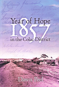
Book, Year of hope: 1857 in the Colac District, 2006
The land, the settlers, and the social institutions which found or altered the character of the small settlement of Colac, Victoria, and its district.Year of hope: 1857 in the Colac district. Dawn Peel. 1st ed. Colac (Vic); Dawn Peel; 2006. x, 212 p.; illus, bibliography. Soft cover. ISBN 0 646 46270 9For Irene - a fellow historian. Dawn Peel. 6/10/06.1857; dawn peel; land; politics; aborigines; religion; history; social institutions; -
 Buninyong & District Historical Society
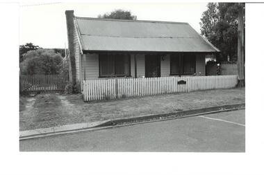
Photograph - Original B/W Photograph, Miner's cottage built on land owned by Thomas Hiscock in Learmonth St west, Buninyong, April 1994
The weatherboard cottage was built in the 1860's on land owned by Thomas Hiscock, the discoverer of gold near Buninyong township.The weatherboard cottage was built in the 1860's on land owned by Thomas Hiscock, the discoverer of gold near Buninyong. It is a good example of a miner's cottage of its era.B/W photo of Miner's cottage, Learmonth St west, Buninyong. Streetscape photo taken in 1993 of a weatherboard building with picket fence.miners cottage, house, building, weatherboard, thomas hiscock, hiscock, buninyong, learmonth st -
 Kew Historical Society Inc
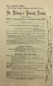
Pamphlet - Document, St Hilary's Anglican Church, St Hilary's Parish Notes, No.70., March 1919, 1919
St Hilary's Anglican Church in Rowland Street, Kew was established in 1888 on land granted to the congregation by the Dumaresq family.The Parish Notes are historically interesting as they outline the various ways in which the Influenza Epidemic of 1919 had an impact on local communities. St Hilary's Church of England Parish Notes from 1919, which includes among other items of interest states that because of the risks of contagion during the influenza epidemic, parishioners are required to worship outside. Written note on front page signed by the Rev Charles H Barnes and dated 16/3/19.st hilary's church of england - kew (vic), churches - kew (vic), influenza epidemic 1919 - kew (vic) -
 Melton City Libraries
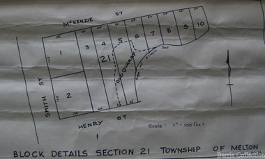
Map, Block details section 21 Township of Melton, 1965
In 1861, Mary Dowling and John Luby obtained Crown Grant land on the corner of Smith and McKenzie Street Melton.Section 21 is covers the block of Smith, Henry and McKenzie Street Meltoncouncil -
 City of Kingston
Pamphlet - Colour, Arthur Tuckett & Son, Auctioneers and Subdivisional Specialists, Attractive subdivisional auction of Station Estate, Moorabbin, 1923
Sales plan for land in the suburb of Moorabbin, bounded by Railway Crescent, South Road, Jasper Road and Pattersons Road.The developing urban area of Moorabbin within the City of Kingston. This land sale pamphlet illustrates the subdivision of land within the municipality and the changing demographic of the district as new houses are constructed.Colour pamphlet advertising an auction of the Station Estate Moorabbin. Incorporates details of the shopping facilities, proximity to the railway line, variety of schools and churches in the area, and a sales plan for home sites and shop fronts. Incorporates a map of the estate bordered by Pattersons Road, Japer Road, South Road and Railway Crescent. Handwritten in grey pencil top right front page: Station Estate / late [indecipherable] Handwritten in red pencil on subdivision map: x [on majority of properties marked on the map] Handwritten in grey pencil on subdivision map: additional subdivisions drawn in and large lines drawn across the mapmoorabbin, land sales, estate -
Moorabbin Air Museum
Book - Dept of Transport Australia description of Air, Land and Sea transport about Australia, AUSTRALIAN TRANSPORT 1973-74, Department of Transport Australia, AUSTRALIAN TRANSPORT 1973-74, 1974
Dept of Transport Australia description of Air, Land and Sea transport about Australia, AUSTRALIAN TRANSPORT 1973-74Embosed symbol of Dept of Transport Australia on a white covernon-fictionDept of Transport Australia description of Air, Land and Sea transport about Australia, AUSTRALIAN TRANSPORT 1973-74 -
 Federation University Art Collection
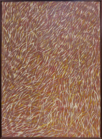
Painting - Artwork - painting, 'Grass Seeds' by Barbara Weir, 1999
Barbara Weir (b. 1945-03/01/2023) Born: In the region of Utopia, North East of Alice Springs, formerly known as Derry Downs Station Language: Anmatyerre and Alywarr Country: Atnwengerrp, Utopia Region, North East of Alice Springs, Northern Territory One of the Stolen Generation, Barbara Weir was removed from her Aboriginal family at the age of nine, and she was raised in a series of foster homes. Reuniting with her mother, Minnie Pwerle, in the 1960s, Weir eventually returned to her family territory of Utopia, 300 kilometres northeast of Alice Springs. Active in the local land rights movement of the 1970s Barbara Weir was elected the first woman president of the Indigenous Urapunta Council in 1985. Barbara’s career as an artist was inspired by the dynamic community of artists at Utopia and the work of her adopted auntie Emily Kame Kngwarreye. Highly experimental in her approach, Barabara Weir tried many mediums before travelling to Indonesia in 1994 with other artists to explore batik technique. She returned full of ideas on how to develop her own style which has since evolved to a more expressive abstract form. Grass Seed is part of her Dreamings and is associated with women’s ceremony and the activity of food gathering of local seeds, grasses, berries, potato, plum, banana, flowers and yams. This item is part of the Federation University Art Collection. The Art Collection features over 1000 works and was listed as a 'Ballarat Treasure' in 2007.Barbara Weir's paintings include representations of particular plants and "dreamings". Inspired by a small grass found in Utopia called Lyaw, Munyeroo or Pigsweed, Barbara's Grass Seed paintings consist of a series of small brush strokes that overlap and weave to create a swaying effect. This Dreaming tells the story of grass seed that is part of the bush tucker found in the region of Utopia. This seed is collected, crushed to a fine powder and is then used to make a bread, very similar to damper. The people of Utopia were still using this seed as late as the 1950s. During that time the seed grew in abundance but as the years passed there were very few good seeds to be found due to bullocks roaming the land and eating the grasses. The people then began to eat a substitute that the white man provided, and today very few Aboriginal people collect these seeds. art, artwork, barbara weir, aboriginal, dreaming, stolen generation, acrylic on linen -
 Bendigo Historical Society Inc.
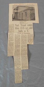
Newspaper - Lydia Chancellor collection: Specimen cottage
Specimen Cottage in Hargreaves Street Bendigo was built by stonemason James Brierley in 1856. He purchased the land at the first land sales in 1854. It is possibly the earliest building still standing in Bendigo. Further information "Written in Stone - The Story of pioneer Bendigo Stonemason James Brierley and his family" Written by Barbara Poustie. Published in 2017. Printed by Bendigo Historical Society.Bendigo advertiser from 04/10/1969. Article titled: Nat. Trust rates this 113 years old lady a "C" details the history of Specimen cottage. In red pen Bendigo Advertiser 4-10-69bendigo building, specimen cottage, james brierly, national trust -
 Whitehorse Historical Society Inc.
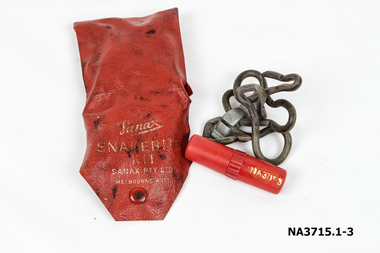
Functional object - Snake Bite Kit, circa 1960's
The Gunning family owned 20 acres of orchard and farm land in High Street Lower Templestowe and kept one of these kits in each vehicle and tractor. They didn't experience a snake problem until the late 1950's when land sub division around their property forced snakes into the area. The family lost one dog to snake bite in the early 1960's.Consists of a Wallet, tourniquet and lancet . 1.Wallet - small red plastic wallet with one press stud to close. Printed in gold on front: 'Sanax Snakebite Kit Sanax Pty Ltd Melbourne Australia 2.Tourniquet - rubber tourniquet looped through a metal clip used to tighten tourniquet. ' Sanax ' embossed on flat of metal clip. 3.Lancet - a three chambered cylindrical container made of red plastic. One end removes to reveal a lancet/ blade, the other end acts as a handle for the blade. Container holds instructions on a small roll of paper. The centre of the container can be be unscrewed to access crystals of permanganate of potash to put on the woundmedicine, first aid -
 Surrey Hills Historical Society Collection
Photograph, Church of Christ, The Avenue, 1990
Built c 1889. The current Church of Christ is on the left. One of the foundation families was that of Mr and Mrs John Woodhead, who owned the land from Union Road to Warrigal Road and from Canterbury to Bona Vista Avenue in 1885. Mr Woodhead built 'Kirkland' in Union Road - in 1889/90. The land for the church was given by Mr Woodhead. Photograph taken in 1990.A coloured photograph of a weatherboard building with two windows at the front with brown painted surrounds, and a brown painted wooden door. There is a path leading to the door and looks to be a building on each side. There is a large tree in the background.Church of Christ/ Surrey Avenuekirkland, house names, union road, surrey hills, warrigal road, canterbury road, bona vista avenue, (mr) john woodhead, church of christ, churches -
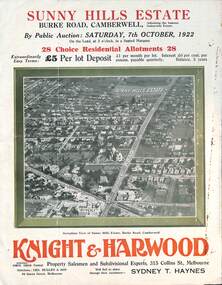 Melbourne Tram Museum
Ephemera - Real estate sale, Knight Harwood, "Sunny Hills Estate" - Burke Road Camberwell, Oct. 1922
Pamphlet advertising the sale of land at the "Sunny Hills Estate" Burke Road Camberwell 7-10-1922. Gives terms of sale, photos showing a nearby shopping centre, recently constructed houses, and plan of the subdivision. Land prices have been written in for each block on the pamphlet. Has a photo featuring Camberwell Junction with a tram, and Burke Road view with trams. Demonstrates the style of land sale pamphlet including the availability of tram services to prospective purchasers.Pamphlet - folded - printed in three colours of cream coloured paper with photographs and plans.has ink notes re sale price and notes.sale of land, trams, real estate, burke road, camberwell, sunny hills estate -
 Ringwood and District Historical Society
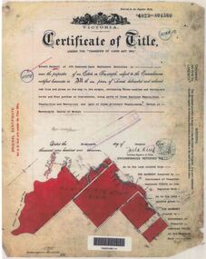
Document - Research Folder, Helm Family, Oban Road, Ringwood, Victoria - 1917-2008
Transcription of conversation with Alma and Kelly Helm by Richard Carter (Past President of Ringwood Historical Society) and Larraine Haslam on 18 July 2008 detailing family history. Certificates of title of land between Oban Road and Mullum Mullum Creek. Six and a half acres sold to the Helm Family in 1917. Includes Certificate of Title Vol 5311 Fol 1062052 Carolyn Mary Glynn dated 27 April 1927. Certificate of Title Vol 4023 Fol 804560 Robert Beckett dated 19th January 1917. Plans of Subdivision including Oban Road, Barnsdale Way, Loughies Track, 1997. Certificate of Title Vol 4029 Fol 805702 Ellen Elizabeth Helm dated 8th February 1917. Transfer of Land (2093031) payment to James William Dartnell by Alma Mary Helm and Elsie May Helm of Oban Road, Ringwood North - 13th August, 1947. -
 City of Moorabbin Historical Society (Operating the Box Cottage Museum)
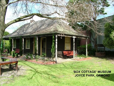
Photograph - ' Box Cottage' Reconstruction, c1841
The original small, pioneer cottage was built in the late 1840s to early1850s, by an unknown pioneer. It was located on part of a 30 Acre allotment that was originally part of Henry Dendy’s Special Survey granted in 1841. The doors and window sashes, (made of red deal joinery timber), as well as the brass locks and fittings, are from the original cottage, and were imported from England.The fire-place bricks are from the original cottage, and are sun-dried, (not kiln fired), and are hand-made. Convict marks can be seen on two bricks.There is a small display of external cladding shingles from the original pioneer cottage. These shingles were hand-split, and most likely made from locally collected timber The nails included in this display were used to fasten the shingles on the original cottage, and are also hand-made. The enamel nameplate, “Colonial”, on the wall of the cottage, was the name chosen for the original pioneer cottage when a later owner, Mr August Rietman and wife Frieda leased the property in around 1917. August purchased the property 1935 for 1200 Pounds approximately and resided there until 1953. In 1974 Mr Lewis, a timber specialist, found the dilapidated building on property he had recently purchased in Jasper Rd and suggested it be reconstructed and relocated. Moorabbin Council agreed and the Cottage was rebuilt just about 250 metres from its original site. The cost of the rebuild was met by 'Victoria's 150th Committee, plus a small grant from the City of Moorabbin, and Mr Laurie Lewis donated much of the timber for the reconstruction. Although 'Box Cottage' is a re-construction, it is an unique museum that, being located in the midst of a modern community in Ormond Victoria, can educate and demonstrate many aspects of the early settler’s way of life in Victoria. As such, it is an invaluable resource for students and all kinds of visitors. The original small, pioneer cottage was built in the late 1840s to1850s, by an unknown pioneer. It was located on part of a 30 Acre allotment that was originally part of Dendy’s Special Survey granted in 1841. The re-constructed pioneer cottage, named ‘Box Cottage’, is located only a matter of metres from the original pioneer cottage site, in Joyce Park, Jasper Road, Ormond, Victoria. The museum has copies of interesting Land Titles associated with the surrounding land, including the site of the original pioneer cottage, from Dendy’s time, and into the 1900s. ‘Box Cottage’ is named after the pioneers, William and Elizabeth Box, who resided in the original cottage from approximately 1865, until Elizabeth’s death in 1914.The re-constructed cottage plan has followed faithfully the original dimensions, and plan of the original pioneer cottage, and as many original items from that cottage’s long occupation have been incorporated. Convict marks on sun -dried, fire-place chimney bricks. Enamel nameplate 'Colonial' circa1915brighton, moorabbin, cottages, pioneers, ormond, colonial, mckinnon, dendy henry, box william, box elizabeth, convicts, rietman august, rietman frieda, rietman stefanie -
 Bendigo Historical Society Inc.
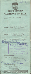
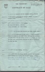
Document - H.A. & S.R. WILKINSON COLLECTION: CONTRACT OF SALE
Contract of sale dated 3rd November, 1959 between Mrs. A. Hemley (seller) and Mr. G.F. * Mrs. P.E. Stacey (buyer). Solicitor for vendor and purchaser: H.E. Every, Dispensary Walk, Bendigo. Property at 44 Wood Street, Long Gully, being part of Crown allotment 4 section P described in certificate of title volume 8088 folio 607. Also that piece of land comprised in certificate of title volume 8202 folio 301 and that piece of land comprised in certificate of title volume 8202 folio 302. Together with all floor coverings, blinds, curtains, electric light fittings and shades. Price 3,700 pounds. Attached 2 copies of statement pursuant to section 34 of the estate agents act 1956 signed by H.A. Wilkinson and 1 copy of engagement or appointment in writing pursuant to section 33 of the estate agents act 1956 signed by the vendor.organization, business, h.a. & s.r wilkinson real estate -
 Bendigo Historical Society Inc.
Document - H. A. & S. R. WILKINSON COLLECTION: CONTACT OF SALE
Contract of sale dated 31st March, 1958 between Mrs. C. M. Cunningham (vendor) and Mr. J. E. & Mrs. D. L. Preece (purchaser). Solicitor for vendor: E. S. Cahill & Son, View Street, Bendigo. Solicitor for purchaser: H. E. Every, Pall Mall, Bendigo. Property: 177 McIntyre Street, Bendigo land containing 1 rood having a frontage of 100 links by a depth of 250 links being allotment 116 section A Ironbark Gully City of Bendigo land described in deed of conveyance no. 942 book 642, together with all floor coverings, blinds, curtains and electric light fittings and shades and "Turner” washing machine. Price: 2,550 pounds. Attached Statement pursuant to section 14 of the estate agents act 1956, Engagement in writing pursuant to section 33 of the estate agents act 1956 and 2 hand written notes.organization, business, h.a. & s.r wilkinson real estate -
 Bendigo Historical Society Inc.
Document - H. A. & S. R. WILKINSON COLLECTION: CONTRACT OF SALE
Conditions of sale by private contract dated 29th November, 1949 between E. G. S. Rasmussen (vendor) and E. Simmons (purchaser). Property: land situate Havlin Street, Bendigo at present occupied by the purchaser, being part of Crown allotments 392 and 393 section H, Parish of Sandhurst City of Bendigo, land described in certificate of title volume 5514 folio 1102695, together with 5 room weatherboard dwelling and all sundry outbuildings. Price 1,200 pounds. Attached 4 hand written notes plus 1 letter dated 29th November, 1949 and signed by Mr. Rasmussen detailing the payment to Mr. Simmons the sum of 300 pounds on 10th January, 1950 and a further 100 pounds on 25th February, 1950. Also a letter dated 29th November, 1949 signed by Mr. Simmons acknowledging receipt of the sum of 400 pounds being part of a loan.organization, business, h.a. & s.r wilkinson real estate -
Bendigo Historical Society Inc.
Document - MARKS COLLECTION: BOUNDY'S FREEHOLD GOLD MINES MALMSBURY
Plan/advertisement 1888 for the sale of the Boundy's Freehold Gold Mines Malmsbury, 260 acres of auriferous and arable freehold land. Document contains map of mines, names include O'Connors Freehold Company, Egyptian Company, Queen's Birthday Company, No.1 South Queen Company, Madam O'Connor's company, Extended South Queen's Birthday Company. Scale 10 chains to one inch. Taken from Mr. H. Archdale's Plan by Walter Sleeman, Mining Mgr., Oct 9th. 1888. On RH side of map Daylesford Road to Malmsbury marked. The land is only about two miles from the Malmsbury railway station. On back of document letter from Henry Nutman, Mining Manager, Queens Birthday Company; Report on Plan Walter Skleeman, M.M.; letter to S. Deeble, 35 Queen St., Melbourne with report on mine from George Jenkyn and Mining Manager's Report in Argus 24th.October, 1888.mine, gold, boundy's freehold gold mine -
 Kew Historical Society Inc
Photograph, J F C Farquhar, The Yarra in Hyde Park, 1891
At the beginning of the 1890s, the Kew businessman and Town Councillor, Henry Kellett, commissioned J.F.C. Farquhar to photograph scenes of Kew. These scenes included panoramas as well as pastoral scenes. The resulting set of twelve photographs was assembled in an album, Kew Where We Live, from which customers could select images for purchase.The preamble to the album describes that the photographs used the ‘argentic bromide’ process, now more commonly known as the gelatine silver process. This form of dry plate photography allowed for the negatives to be kept for weeks before processing, hence its value in landscape photography. The resulting images were considered to be finely grained and everlasting. Evidence of the success of Henry Kellett’s venture can be seen today, in that some of the photographs are held in national collections.It is believed that the Kew Historical Society’s copy of the Kellett album is unique and that the photographs in the book were the first copies taken from the original plates. It is the first and most important series of images produced about Kew. The individual images have proved essential in identifying buildings and places of heritage value in the district.Hyde Park is now a small recreation reserve bordered by Willsmere and Kilby Roads and White Avenue. In 1982, Hyde Park was cut off from the Yarra River by the construction of the Eastern Freeway. The building of the latter was to transform the natural landscape, including the Yarra, as well as Hyde Park. The construction of the Freeway makes it difficult to view the scene with the photographer’s eye. Today’s Hyde Park is located on land purchased in 1847 by John Cowell, and in 1851 Catherine Cowell, yet the scene selected by the photographer may well have been located on farmland owned by the Wills family. Farquhar’s point-of-view emphasises both the pastoral and recreational elements of the scene: the grazing cows, three boys, and in the distance two figures, seated on the bank with a parasol. By 1891, an environmental consequence of human activity, including farming, was deforestation, leading to the erosion of the south bank of the Yarra. In contrast, the land on the Alphington side of the river in 1891 included remnant bushland.The Yarra in Hyde Parkkew illustrated, kew where we live, photographic books, henry kellett, yarra river -
 Kew Historical Society Inc
Plan - Subdivision Plan, Camberwell Mountain View Estate, 1923
The Kew Historical Society collection includes almost 100 subdivision plans pertaining to suburbs of the City of Melbourne. Most of these are of Kew, Kew East or Studley Park, although a smaller number are plans of Camberwell, Deepdene, Balwyn and Hawthorn. It is believed that the majority of the plans were gifted to the Society by persons connected with the real estate firm - J. R. Mathers and McMillan, 136 Cotham Road, Kew. The Plans in the collection are rarely in pristine form, being working plans on which the agent would write notes and record lots sold and the prices of these. The subdivision plans are historically significant examples of the growth of urban Melbourne from the beginning of the 20th Century up until the 1980s. A number of the plans are double-sided and often include a photograph on the reverse. A number of the latter are by noted photographers such as J.E. Barnes.The so-called Camberwell Mountain View Estate was a subdivision on ‘the corner [of] Burke Road, Eyre and Wills Streets, Deepdene’. The Estate was not the first attempt to subdivide this land holding. In 1884, 1888 and 1894 the Belmore Park subdivision proposed 18 allotments for this parcel of land. The final stages of the Belmore Park subdivision occurred during the Depression of the 1890s. Apart from perhaps one block facing Burke Road, which is unnumbered in the Mountain View Estate subdivision, the rest must have remained unsold. The later subdivision would redraw the original 18 allotments, creating 22 new lots. In the Locality Plan on the left side of the subdivision plan, Deepdene Station, which formed part of the Outer Circle Railway is represented, as is the location of Deepdene Primary School. A selling point was the proposed extension of the Burke Road tram beyond its terminus at Cotham Road. The extension did not eventuate.subdivision plans - camberwell, mountain view estate -
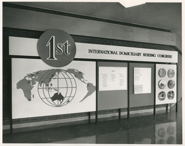 Royal District Nursing Service (now known as Bolton Clarke)
Photograph - Photograph, black and white, Barry Sutton, 05.02.1970
This sign was displayed at the 1st International Domiciliary Nursing Congress which was hosted by the Royal District Nursing Service (RDNS).The 1st International Domiciliary Nursing Congress was hosted by Royal District Nursing Service (RDNS). Mrs. D.(Elsa) Hallenstein, President of RDNS, presided over the opening ceremony with the Prime Minister of Australia, the Hon John Gorton opening the Congress. It was held in Melbourne and ran from the 1st to the 8th of February 1970. Many delegates came from around Australia and overseas; from the World Health Organisation; from the North American continent; from Europe, from Asia and from the Pacific. Black and white photograph showing the sign displayed at the 1st International Domiciliary Nursing Congress. Across the photograph is a long black metal stand, with eight legs, which holds a large board. On the upper quarter can be seen to the left a medium sized black circle which has the lettering '1st' outlined in white on it. To the right of this is the black lettering "International Domiciliary Nursing Congress" in capital letters on a white background. Below the black circle, on a white background, is a large round white globe outlined in black and with black spaced vertical and horizontal grids on it. In the lower centre of this is the black coloured land mass of Australia. Over the left hand top section, and above and to each side of the white globe are different land masses of the world displayed in grey. To the right of this there are two grey sections which are divided vertically with a black line,.and contain information on white sheets. To the right of that is a white section with round photographs in three pairs running down the board.Photographer stamp. Quote No. JE 4royal district nursing service, rdns, mrs d. (elsa) hallenstein, hon john gorton, 1st international domiciliary nursing congress -
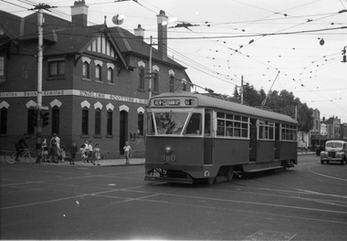 Melbourne Tram Museum
Negative, Wal Jack, 9/02/1951 12:00:00 AM
Black and white negative, by Wal Jack, of PCC 980, northbound bound in Glenferrie Road at High Street with the destination of Kew Cotham Road. The Bank was replaced by a more modern looking building during the 1970's. In the background is the ES&A bank on the corner. Jane Nigro advised 9/9/2020: "1907 Photo of the E. S. & A. Bank on the corner of High Street and Glenferrie Road, Malvern. In 1885 land on corner of Glenferrie Road & High St. (40' x 150') was purchased by E.S. & A. Bank. A condition of sale was that the bank erect on the land a 'substantial brick building to be used as a branch bank', within 24 months. The E.S. & A. Bank, single-storey four roomed brick, was built in 1888. The first manager was Frederick Leonard. In 1907 a second storey, including residential quarters for the manager, was added to bank at a cost of £1400.The Bank was demolished in 1958-9and replaced with present building."trams, tramways, pcc class, glenferrie road, route 69, kew- cotham rd, tram 980 -
 Greensborough Historical Society
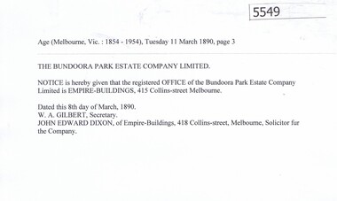
Article, Bundoora Park Estate Company, 1890-1894
Bundoora Park Estate Company Limited was one of the many land development speculative companies operating in the Greensborough area in the 1890s. 5 p. of transcripts of five newspaper articles bundoora park estate campany limited, bundoora -
 Greensborough Historical Society
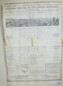
Advertising Leaflet, Knight & Harwood, Electric Station Estate, Watsonia, 19/07/1924
Photocopy of auction leaflet for land north of Watsonia Railway Station, Saturday 19th July 1924. Auctioneer Knight & Harwood.Photocopy of auction leaflet 1 p.watsonia, watsonia electric station estate -
 Eltham District Historical Society Inc
Photograph, Looking south along Main Road from Diamond Street Railway Crossing, Eltham, February 1968, Feb 1968
Luck Street enters Main Road from the left behind the Caltex garage. Note the house on right hand land.In February 1968 an unknown person took a series of photos from the Eltham Hotel at Pitt Street heading north along Main Road through the shopping centre to just north of Elsa Court covering the length of the section of Main Road which was duplicated shortly thereafter. Shows the condition and environment of the streesscape of Main Road, Eltham immediately prior to the duplication between Pitt Street and Elsa Court through the shopping centre. Also shows a number of shops and businesses that operated at that time.Black and white photographduplication, eltham, main road, diamond street, railway line, railway crossing, caltex service station, supa-value self service -
4th/19th Prince of Wales's Light Horse Regiment Unit History Room
Newspaper cutting, Drill Hall's Battle Over, 8 Dec 1994
The 4/19 PWLH Regiment was located at Bougainville Barracks, Carlton, until the land was sold off by Army for housing development.An article from the Herald Sun of Thursday 8 Dec 1994 about the closing of Bougainville Barracks in Park Street Carlton. It carries a photograph Col Frank Pearson with a Light Horse uniformed mannequin in front the 4th (late 20th Corangamite) Light Horse honour boardnewspaper, bougainville barracks -
 City of Moorabbin Historical Society (Operating the Box Cottage Museum)
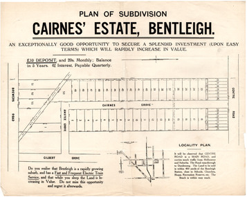
Flyer - Plan of subdivision for Cairnes' Estate, Bentleigh, mid 1920's
Land sales in the Municipality of Moorabbin increased when the train line from the City to Frankston was electrified.Example of the progress of the Municipality of MoorabbinExample of the progress of the Municipality of MoorabbinAdvertising flyer for auction of real estate sales - plan of building blocks for saleCairnes' Estate, Bentleigh 38 home sites and 14 business sitescentre road, cairnes grove, ansett grove, brewers road, bentleigh, land sales, real estate -
Tatura Irrigation & Wartime Camps Museum
Suitcase
Thomas Jervis Bowen, Land Sergeant, a guard at Camp 3? bought the suitcases from an inmate, passed on to his daughter.1 of 2 suitcases. Constructed from plywood obtained from lining of hut interior. Made by an unknown German/Italian internee. Acquired by a guard at camp 1 (Thomas Bowen). See C0192 for second suitcase.tatura, bowen, thomas, camp 3 garrison, personal, effects, travel, goods