Showing 13337 items matching "stations"
-
 Wodonga & District Historical Society Inc
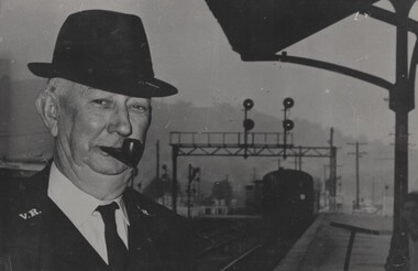
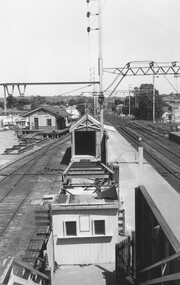
Photograph - Fred Rochow Railways Collection - Guard Hugh Fraser's last trip, 10 May 1971
The Fred Rochow Railways Collection incorporates photos related to the operation of the Wodonga Railway Station including different types of trains and railways staff C. 1930 – 1990. It was donated to the Wodonga Historical Society by Fred Rochow, a railwayman who spent many years based in Wodonga. He joined the Victorian Railways on 17th June l947 and retired in 1988. For some time, he was a member of the Australian Federated Union of Locomotive Enginemen and served a term as a member of the Trades Hall Council. He had an extensive knowledge of the struggles that took place to achieve better conditions for railway workers. Fred worked for many years as a fireman and then worked his way up the ranks to driver, experiencing many changes from the days of steam locomotives through to diesel trains, locomotives and even the modern XPT train. He worked throughout Victoria at different stages of his career, with his final working years focused on the northeast of Victoria and the Albury to Melbourne line. After his retirement, Fred continued to share his love of steam miniature trains with the community.This collection has local and statewide significance as it captures images of trains, locomotives and personnel who operated the railway services in Wodonga and throughout Northeast Victoria. The railways played a critical role in opening up Victoria and connecting Australia for trade, business, social communication and transport.Guard Hugh Fraser about to take his last ride on 10 May 1971. He started his career with Victorian Railways as a Lad Porter on 1 July 1924 at Oakleigh Station. He worked as a Shunter at Korumburra, Williamstown Pier, Woodend and Ballarat. Hugh was Leading Shunter at Wodonga from 1935 until 1941. His final position was as Guard at Wodonga from 1941 until May 1971.railways wodonga, fred rochow, wodonga railwaymen, hugh fraser -
 Federation University Historical Collection
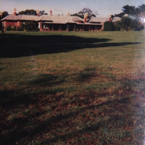
Photograph - Photograph - Colour, Banongill Station Skipton, 1987
Photo possibly taken on a family visit to an open day at the Station in 1987. The Banongill Station homestead was established in 1853, originally an outpost of Borriyalook Station, which was owned by pastoralist and philanthropist Francis Ormond, founder of Ormond College. Part of Borriyalook was separated from the home station in the 1850s and renamed Banongill.Coloured photograph.1 Verso-Skipton1987 Banongil Homestead and lawns .2 Rare palm trees in lawn at Banongil Homestead .3 Paths Lawn and garden of Banongil Homestead Skipton -
 Whitehorse Historical Society Inc.
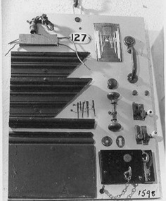
Archive - Building Fittings, C1920s
Samples of door handles and fittings used in the Station Master's House at Mitcham Railway StationDoor handles, locks, skirting board, picture rail architrave, light connections, early wiring nails, number - all mounted on large board.|Every Railway House had a number - this one was DR.buildings, fittings -
 Bendigo Military Museum
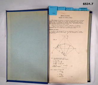
Booklet - Royal Australian Survey Corps - School of Military Survey Precis - Formula for Survey Calculations, School of Military Survey, Balcombe, Circa 1960s
This selection of Precis was produced by the Royal Australian Survey Corps, School of Military Survey, Balcombe, circa 1960s. The Precis are intended to instruct RASvy Surveyors employed on Engineer/ Field Survey Tasks on the calculations necessary for Surveying formula. The blue hard covered foolscap sized booklet held together with two Chicago screws contains 7 x precis listed below. .1 Setting out simple Curves .2 Earthworks .3 Calculation of area by double Latitude .4 Notes on Station Adjustment by Least Squares .5 Notes on Figure Adjustment by Least Squares .6 Technical Memo No1, Computation of Tellurometer Traverses using Plain Angles and Plain Distances by WO2 R Wilson RASvy (later Major) .7 Computing Traverses in Plane CoordinatesBlue Hard covered foolscap sized booklet held together with two Chicago screws. Booklet contains 7 x precis. .1 Setting out simple Curves .2 Earthworks .3 Calculation of area by double Latitude .4 Notes on Station Adjustment by Least Squares .5 Notes on Figure Adjustment by Least Squares .6 Technical Memo No1, Computation of Tellurometer Traverses using Plain Angles and Plain Distances by WO2 R Wilson (later Major) .7 Computing Traverses in Plane Coordinatesroyal australian survey corps, rasvy, fortuna, army survey regiment, army svy regt, asr, school of military survey -
 St Kilda Historical Society
Photograph, St Kilda Railway Station - images collection
Opened in 1857, St Kilda Railway Station is the oldest surviving railway station in Victoria. In the 1920s it was the second busiest station in Victoria after Flinders Street. Competition from motor traffic led to the decline of the station and of St Kilda itself. Services on the line were reduced in 1981 and it was converted to a tram route in November 1987. In 1989, several fires damaged the timber station building and by December, the roof had been destroyed. Metropol Apartments at 60 & 64 Fitzroy Street, completed by 2002, were constructed on the station forecourt site. The former station has been heavily redeveloped and now houses bars, restaurants and retail outlets. Colour photographst kilda, st kilda railway station, st kilda train, fitzroy street -
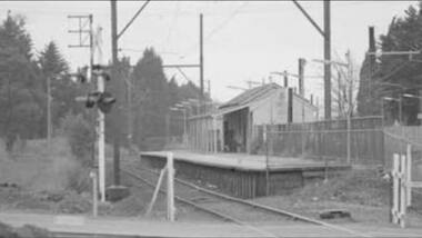 Greensborough Historical Society
Photograph - Digital Image, Watsonia Railway Station before 1970, 1960s
Watsonia Station before the 1970s. This photograph shows the old station. The new Watsonia Station was opened in 1977 when the rail line was lowered to remove level crossings and duplicate the line between Macleod and Greensborough.Digital copy of black and white photographwatsonia station, hurstbridge rail line -
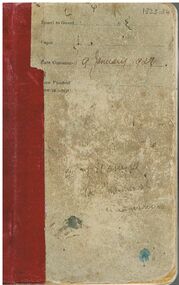 Bendigo Historical Society Inc.
Book - BADHAM COLLECTION: VICTORIAN RAILWAYS NOTE BOOK DATED 9.1.1928
VICTORIAN RAILWAYS small note book, hard cover with purple binding dated 9.1.1928. Each page details the Name of the Driver, Fireman, Van man and State of weather. Number and Class of Vehicles, Tonnage Contents, Total Description of Loading from Station to Station, Time of arrival and departure, Loco shunting, Van goods, Blocked by signals, other causes. Inside cover steam train instructions from T.B Molomby, General Supt, of Transportation. Reference is David Badham.document, memo, railway, victorian railways small note book, hard cover, t.b molomby, general supt, of transportation -
 Bendigo Historical Society Inc.
Map - CAMPBELL COLLECTION: BENDIGO AND DISTRICT MAPS, 8-7-29
Map. Rifle Range, Parishes of Wellsford and Sandhurst. Scale 20 chains to 1 inch. Total area by Planimeter 5916 acres. Wallan and Bendigo Railway line. Rifle Range. Axedale township and station 8 miles. To Longlea Ryl station 2 1/2 miles. To Epsom 1 1/2 miles. To Bendigo 3 miles. Compiled in W.P.D. from Assessment and Parish Plans by H.A.D 8-7- 29 (number 367 in map cupboard 1)H.A.D.(H.A.Darby)map, bendigo, allotments -
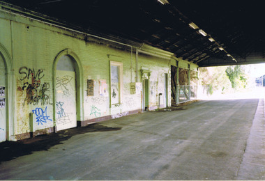
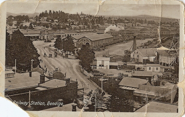 Bendigo Historical Society Inc.
Photograph - RAILWAY STATION BENDIGO, early 1900's ?
sepia photo (postcard ) photo taken from elevated position on north side of Mitchell Street, of Railway Station, Bendigo. Fortuna Hustlers ( 2240 ft. ) mine on LH side of photo. Engine shed in centre of photo, with steam issuing from engine behind. ( not visible ) Horse and buggies in middle of street. Mitchell Street is unmade. On bottom left of card ' Railway Station, Bendigo ' On back 'Fortuna Hustlers 2240 ft ' and Mng 8, Royal Historical Society of Victoria, Bendigo Branch.place, landscape view, bendigo railway station -
Bendigo Historical Society Inc.
Map - TARNAGULLA : COUNTY OF BENDIGO, 13-5-22
Map. County of Bendigo, County of Gladstone.Inglewood, Glenalbyn, Kingower, Moliagul, Waanyarra, Laaneoorie, Woodstock, Loddon River, Township of Tarnagulla, Township of Newbridge, Township of Llanelly, Dunolly to Inglewood Railway, Tarnagulla Rifle Range, Laurie Station, Bullabul Creek, Arnold Township, Arnold Railway Station. Photo-Lithographed at the Department of Lands and Survey, Melbourne by W.J. Butson, 13-5-22.Price 1/-.By authority A.J. Mullett, Government Printer, Melbourne. (number 118 in map cupboard 1)A.J. Mullett, Government Printer, Melbourne.map, bendigo, tarnagulla -
Bendigo Historical Society Inc.
Map - TARNAGULLA : COUNTY OF BENDIGO, 1959
Map. Tarnagulla, County of Bendigo, County of Gladstone, Inglewood, Glenalbyn, Kingower, Moliagul, Painswick, Waanyarra, Laanecoorie, Woodstock, Derby, Loddon River, Dunolly to Inglewood Railway, Laurie Railway Station, Township of Tarnagulla, Tarnagulla Rifle Range, Township of Llanelly, Arnold Railway Station, Bullabul Creek, Kangderaar Creek, Township of Newbridge. By authority A.C. Brooks, Government Printer, Melbourne. Drawn and reproduced at the Department of Lands and Survey, Melbourne, 1959. (number 117 in map cupboard 1)A.C. Brooks, Government Printer, Melbourne.map, bendigo, tarnagulla -
 Port Melbourne Historical & Preservation Society
Postcard - Port Melbourne series, Alison Kelly, 1991
Both photographers were concerned about heritage places soon to be demolished or altered. Printing of the postcards was paid for by Port Melbourne Council.From a set of nine colour postcards featuring heritage places on the Port waterfront. Images by Alison KELLY (nos 4-9) and James LAURITZ (nos 1-3) 1991 1. Aerial photo of Bay St. 2. Starch factory shell. 3. Sunset over Station Pier. 4. Beacon (outer) 5. Gatehouse Station Pier. 6. Seamen's Mission building. 7. Abel Tasman ferry. 8. Old Eastern kiosk. 9. Centenary Bridge stairway.piers and wharves - station pier, piers and wharves - princes pier, piers and wharves - lagoon pier, beacons, built environment, transport - ferries, missions to seamen, james lauritz, alison kelly, abel tasman -
 Whitehorse Historical Society Inc.
Photograph, Mitcham Scene C.1910, C.1910
Original Photo courtesy of Melbourne WaterFramed Black and White Photo of Whitehorse Road, Mitcham, in approx 1910 showing St Johns Roman Catholic Church - School (Church 1872-1952 and School 1872 - 1931) in centre, the School Teachers Cottage at left (1902 - 1935)and Mitcham's first Police Station (1888 - 1950) on the right. In the background in the extreme can be scene the original Mitcham Railway Station (1882)In the foreground is what was known as 'The Great 3 Chain Road' now Whitehorse Road (Maroondah Highway).st john's catholic church mitcham, whitehorse road, mitcham, school teacher's cottage, mitcham police station, mitcham railway station, great three chain road, melbourne water -
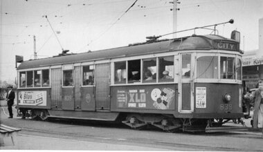 Ballarat Tramway Museum
Photograph - Black & White Photograph/s, late 1950's or early 60's?
Black and white photograph, of MMTB W5 839 at the roundabout at corner of Mt Alexander Road and Fletcher St. Essendon, Essendon Station late 1950's or early 1960's. In the background is the railway bridge over Mt. Alexander Road. All blinds drawn. Tram showing destination "CITY". On the sides of the tram are advertisements for "Bluo" and "XLO Sponge cloth". On the front of the tram is an advertisement for radio station 3AW, Amateur Hour, Terry Dear. Photograph not well focused. trams, tramways, essendon, mmtb, mt alexander road, tram 839 -
 Ballarat Tramway Museum
Photograph - Colour Photograph/s, Sturt Keenan, 21/11/2000 12:00:00 AM
Set of 14 colour prints of the COTMA Conference non-tram events, around the depot, Ballarat Railway Station, Olympic Rings, Lake Wendouree, Ballarat East, Lydiard St. Nth, Royal Mail Hotel Sebastopol, Bungaree Railway Station site and Sovereign Hill. Photos taken by Stuart Keenan. Image taken at Sovereign Hill 19/11/2000. Others - 20 and 21/11/2000. See Reg Item 2704.1 for programme. Printed on Agfa paper.btm, cotma, bungaree, sovereign hill, ballarat railway station, lake wendouree -
 Bendigo Historical Society Inc.
Photograph - PHOTOGRAPHS OF BENDIGO
Various photographs of Bendigo. There are two Kodak packets; one has of photos along with the negatives, the other has only negatives. There are 29 photos in total with 19 in the packet and 10 in plastic pockets (shown in the attached images). The photos include images of the Bendigo Easter Parade, St Paul's Church, a petrol station in Ellis St, Flora Hill, a house in Quarry Hill, Havlin St East, Mitchell and Hargreaves Streets and a train in the park outside the Bendigo railway Station in the mid 1970s.bendigo easter parade, mitchell st, hargreaves st, quarry hill, ellis st, havlin st, steam train, trains, bendigo railway station, 1970s -
 Melbourne Tram Museum
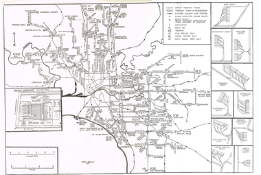
Map, Track plan or track map or layout of the Melbourne system, c1973
Track plan or track map or layout of the Melbourne system showing track layout, crossovers, depots, workshops and route numbers, terminus, substations, Bundy clocks, layout of Preston works. On the rear is a detailed layout of the city area. Shows railway stations but not the station names and rivers. Printed on cartridge paper. No details of to who prepared the plan or the drawing or date. Wattle Park line has been duplicated (Sept 1970), but the Essendon Airport line remains (closed Oct. 1976).trams, tramways, mmtb, track layout, junction, depots, substation, plans, trackwork, route numbers, terminus, map, bundy clock -
 Melbourne Tram Museum
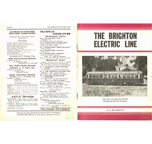
Book, Leon Marshall-Wood, "The Brighton Electric Line", 1958
Book - 20 pages including card covers - the history of the Brighton Electric Line by Leon Marshall-Wood, published 1958, 2nd edition. Gives a brief history of the electric tramway operated by the Victorian Railways between St. Kilda Station and the Brighton Beach railway station, that commenced operation in 1905. Published by Traction Publications. Has details of the AETA on the back cover and listing of some publications. See Reg Item 2062 for the 1st edition and 1351 for the 3rd Edition.trams, tramways, vr, melbourne, brighton, st kilda -
 Melbourne Tram Museum
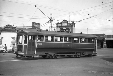
Negative, Wal Jack, 23-2-1942?
Black and white negative, by Wal Jack, of T 178 at Elsternwick, Glenhuntly Road. The tram has been modified with air operated folding doors - see page 65 of Destination City, Edition 5 for further details. In the background are buildings for Apps & Sons Undertakers, James Smith Station Estate Agency, a hair salon, a Shell service station which has motor cycle sales. Photo not dated in album, but was with three negs of T177 at Elsternwick on 23-2-42.trams, tramways, elsternwick, glenhuntly rd, t class, tram 178 -
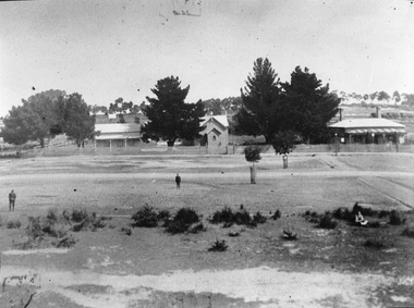
 Linton and District Historical Society Inc
Photograph, Linton Township from Slaughterhouse Hill, circa 1920s, 1920
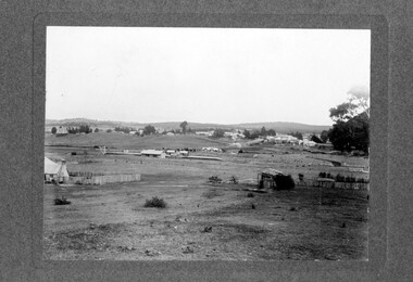
Slaughterhouse Hill was so named because Bennett's butchers had a slaughterhouse there.A view of Linton taken from Slaughterhouse Hill to the north-east of the town. Numerous buildings are identifiable in the photograph. In the middle foreground are the railway station, platform and station-master's house. The Grenville Standard building is visible in Clyde Street, and the Post Office and Bank of NSW buildings can be seen near the corner of Clyde and Sussex Streets. In the distance (along Sussex Street) the Royal Standard Hotel and the Shire Offices (original building) can be seen. St Paul's Church of England is on the far left of the photograph."Esther Cluff, Linton".linton township, slaughterhouse hill -
 Melbourne Tram Museum
Photograph - Digital Image, Kevin O'Reilly, "Merri Creek on CD, of looking from above Rushall station towards Clifton Hill Station, c1930's
Image from CD (Compact Diskette for use in computers) - see Reg Item 135. Image titled "Merri Creek on CD, of looking from above Rushall station towards Clifton Hill Station with the Merri Creek on the left side of the photo. Shows cable trams in Queens Parade, cable trams shunting, the Clifton Hill cable tram depot, and the railway bridge over Merri Creek. 1930's? Photo has lots of white spots on the image.trams, tramways, merri creek, clifton hill, rushall station, cable trams -
 Kiewa Valley Historical Society
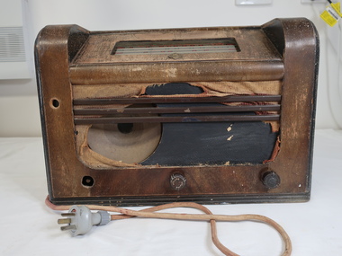
Radio with Speaker
Preiously in Kiewa Valley collection (KV 187) Monarch was a popular brand of radios prior to the invention of TV in the 1960s. People relied on radios for news, sport, music, and serials eg. Blue Hills.Owned and used by a resident of the Kiewa Valley. It was popular during the 1940s and 1950s appealing to all members of the family.Brown bakelite radio with electric cord attached. Top front: Inset: Window with 5 stations - 'Sydney, Melb., Adelaide, Perth, Brisbane" alternating red and green showing radio station's initials in red and green. marked black line across the top. In front of the window. There is an embossed badge inscribed 'Monarch'. Front: damaged showing speaker on left and 2 knobs - one in the middle "volume' and one on the right. The one on the left is missing. The back panel is missing therefore exposing the 'workings' of the radio. radio, wireless, monarch radios, entertainment -
Port Melbourne Historical & Preservation Society
Photograph - Sandridge Station, 1862
Image of Sandridge station (Port Melbourne) in 1862. Shows steam train, goods carriages, workers and sheds. The driver of Engine No 8 is Mr W Pattison and the fireman Mr D McFarlane. The engine in the background is No 5, driver Mr P Turville. Standing at the side of No 8 are messrs Bond and Williams, the lessees of the refreshment rooms.t thr front buffer are Mr Moss, lightman, with a son of Mr Pattison.The Station Master Mr Neville is at the extreme right. Other people unknown.transport - railways, sandridge railway station, william pattison, d macfarlane, thomas turville, bond, williams, moss, neville -
 Ringwood and District Historical Society
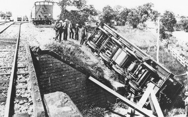
Photograph, Train derailment at Wantirna Road subway in Ringwood, looking towards station. Station St. on right. 1/2/1902
Black and white photographs - 2 copiesVarious accompanying inscription beneath and on back of photographs. They read as follows: "Train derailment at Wantirna Road subway looking towards station. Station St. on right. 1/2/1902. This date has been written as 1908 on other locations in other places. Area behind engine was later railway car park." "Ringwood derailment 1902 (copied from magazine Latrobe library [ARHS Vic. Div. photo collection #748-1]. Cross at lower right marks spot from where fireman McKeone was rescued. Wantirna Rd. underpass. Station to left". -
 Ringwood and District Historical Society
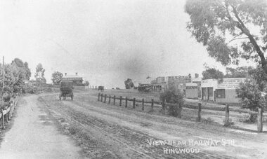
Photograph, Maroondah Highway Central, Ringwood. Main Street looking west from Warrandyte Road- 1908
Black and white photograph (2 copies)Written in lower right corner of photograph, "View near Railway Stn. Ringwood". Typed below one photograph: "Maroondah Hwy looking towards city with Warrandyte Rd coming in from right. Old Station Master's residence on left. Road had two levels here." Bank is E.S. & A. Agency. Bamford's Timber on right. Station Masters house on left. -
 Ringwood and District Historical Society
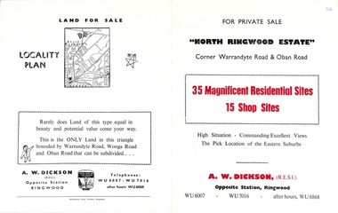
Flyer, Land Sale Brochure, North Ringwood Estate, Ringwood, Vic. - 1958
Double-sided land sale advertisement for sale of 35 residential and 15 shop sites on the corner of Warrandyte Road and Oban Road, Ringwood North, Vic., including locality plan and features of the estate.Subdivision includes Oban Road, Warrandyte Road, and Dickson Crescent. Agent: A.W. Dickson, Opposite Station, Ringwood. (Phone) WU6007, WU7016, after hours WU6868. -
 Ringwood and District Historical Society
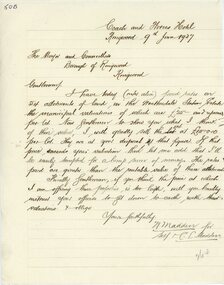
Letter, Letter from N Madden to Mayor and Councillors , Borough of Ringwood. 1937
Hand written letterLetter is from N.Madden -Coach and Horses Hotel, to the Ringwood Borough Council, dated 9th June 1937. Contents regarding Allotments of land in the Heatherdale Station Estate. -
 Ringwood and District Historical Society
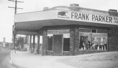
Photograph, Porters shop at Ringwood Railway Station entrance.c1940's
Black and white photograph (2 copies)Written on rear of backing sheet: "Porters shop at Railway Station entrance, c1940's". Sign above shop reads Frank Parker- Real Estate Agent. -
 Ringwood and District Historical Society
Photograph, Ringwood Railway Station Building ramp to No.2 platform , 1963
Blackand white photographTyped below photograph, "Building ramp to No.2 platform Ringwood Railway Station, 1963". Written on rear of photograph - Old Goods Shed {1889} Still there {in 1963} -
 Dandenong/Cranbourne RSL Sub Branch
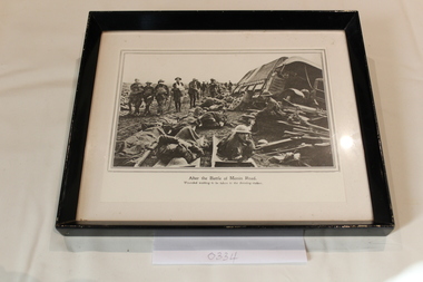
Photograph - Framed Photograph, Circa 1940s
Black framed - black and white photograph.Photograph inscribed " After the Battle of Menin Road". Shows wounded soldiers waiting to be taken to the dressing-station. This photograph part of set of three # 0332 - 0334 & 0335.