Showing 8323 items
matching the bridge
-
 Clunes Museum
Artwork, other - ETCHING, PEN & INK, MRS. JANET McDONALD (NEE DRIFE)
THIS LLUSTRATION WAS GIVEN TO MRS. HOLLAND ON THE THIS DRAWING WAS GIVEN TO MRS. HOLLAND ON THE OCCASION OF HER WEDDING, BY THE ARTIST MRS. JANET McDONALD WHO MARRIED IN WESTERN AUSTRALIA AND LIVED THERE FOR 50 YEARS BEFORE RETURNING TO CLUNES TO LIVE IN SERVICE STREET, NEXT DOOR TO RIDLEY'S.WOODEN FRAME, GLASS COVERED. PEN AND INK DRAWING OF LADY WITH BASKET. TWO SWANS ON WATER. SMALL HOUSE AND MANY TREES IN BACKGROUND. SHRUBS IN FOREGROUND. WOODEN BRIDGE.local history, illustration, etching, paintings, drawings -
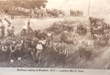 Lakes Entrance Historical Society
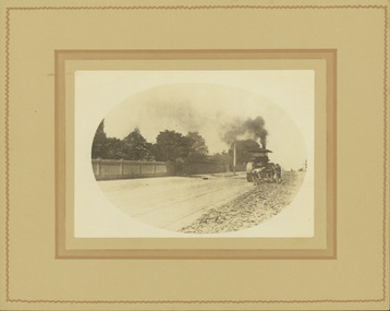
Photograph - Railway Cutting, Bruthen Victoria, 1912
Sepia toned photograph of workmen with horses and drays working on railway cutting at Bruthen Victoria. Also a black and white photograph of a goods train on bridge at Bruthen 1920 cRailway cutting at Bruthen 1912 - courtesy Mrs E Nealpublic works, railway -
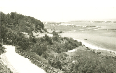 Lakes Entrance Historical Society
Postcard - Lakes Entrance viewed from Jemmys Point, Rose Series, 1925 c
Post and rail fence beside highway and no vegetation on sand dunes eastern part of Cunninghame ArmBlack and white postcard showing view of Cunninghame Arm from Jemmys Point, gravel Princes Highway, North Arm bridge and end of town Lakes Entrance VictoriaNearing Lakes Entrance on the Princes Highwaytownship, waterways -
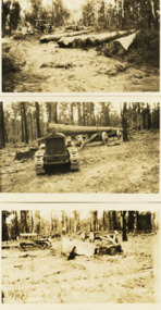 Lakes Entrance Historical Society
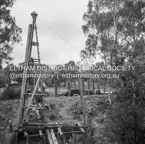
Photograph - Foundation piles for Swan Reach Bridge, Country Roads Board, 1925 c
Black and white photographs of preparation for construction of the Swan Reach bridge showing five large piles cut at the CRB timber coup at Won Wron South Gippsland Victoriabridges, construction, machinery -
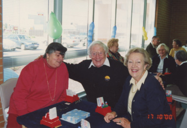 Lakes Entrance Historical Society
Photograph - Bridge Club , Lakes Entrance Victoria, Lakes Post Newspaper, 1/10/2000 12:00:00 AM
Colour photograph taken at Bridge Club Seventeenth Birthday celebration showing President Ann den Houten Treasurer John Roseman and Mel Robinson Lakes Entrance Victoriaclubs, recreation, cards -
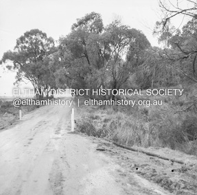
 Eltham District Historical Society Inc
Postcard - Photograph postcard, Old Bridge, Kaylock's Crossing, Brougham Street, Eltham, c.1912
Date estimated to be circa 1912 based on the style of printing on the reverse of the card - Kodak Austral paper for real photo postcards, the paper was manufactured c.1908-1914 (See also POSTCARDS ON KODAK PAPER - IS IT POSSIBLE TO "DATE" THEM? http://tps.org.au/bb/viewtopic.php?t=115) Brougham Street was created in Josiah Holloway's 1851 subdivision of Little Eltham. It was one of several east-west streets shown on the subdivision plan as crossing the Diamond Creek. The western part was named Wellington Street on the subdivision plan but was later changed to conform with the name of the eastern part as acknowledgement of the continuity of the street. It is not known when the first bridge was constructed in Brougham Street however it was certainly mentioned at Council’s meeting of 2 June 1884 as being in a dangerous state of repair. This photo (c.1895) of an old bridge shows a very low-level simple log girder bridge crossing the creek at a right angle and so the approaches involved bends in the road alignment. This bridge was generally known as Kaylocks Bridge or Kaylock’s Crossing after the owner of the adjoining land. It was most likely built from around the mid-1850s, or a crossing of some fashion established as Richard George Kaylock, butcher of Little Eltham and his wife Emily Ann settled there in 1854. His property was in Wellington Street (now Brougham Street) and apparently extended across the Diamond Creek. The land on the western side of the creek was farmed, the house being on the eastern side. Kaylock's Bridge formed part of the original coach road to Eltham and in 1922 was described as an "old rustic bridge". Its low level and insubstantial construction made it susceptible to flood damage, necessitating frequent closures until repairs could be carried out. In September 1922, Council called for tenders for a new timber bridge to be constructed at Kaylock’s crossing. An engineering assessment carried out for the Council by Macleod Consulting at the time of the replacement suggested that the construction details indicate that it was in the 1900s, however this dating could possibly have been the result of numerous repairs undertaken over the years to flood damage. The tender was awarded to Mr Weller of Kangaroo Ground who commenced work in February 1923 on a higher-level timber trestle bridge. Work was slowed due to illness of the contractor and the accidental death of a man in March 1923 following the collapse of the bank after he had jumped into a hole that had just been blasted. The bridge was completed around July 1923 at which point the old structure was pulled up, marking what was described in the ‘Advertiser’ newspaper as the passing of an old and well-loved landmark in the district. In April 1924 the approach to Kaylocks bridge was washed away during the heavy flooding that destroyed the Main Road bridge. The western side was repaired, and an extra span was added to the eastern side using timber from the destroyed Main Road bridge. The bridge was again severely damaged four months later in August 1924 When a lack of finances delayed repairs to the Bridge Street bridge in 1931 (also referred to as Obelisk Bridge at the time), traffic had to detour via Brougham Street for some time. Local residents feared that the Bridge Street bridge might never reopen. Kaylocks Bridge was constantly subject to damage by floods. In the 1934 flood it was submerged by two feet of water. In more recent times the bridge was again severely damaged by flooding and repairs made. A new bridge and adjoining footbridge were constructed in 2009.Digital file only Postcards scanned from the collection of Michael Aitken on loan to EDHS, 2 Sep. 2022michael aitken collection, eltham, postcards, bridge, brougham street, diamond creek (creek), kaylocks bridge, wellington street -
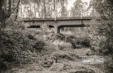
 Eltham District Historical Society Inc
Slide, Construction of Eltham Town Park, 22 Feb 1974
Construction of Eltham Town Park, later renamed Alistair Knox Park. In the foreground is where the Diamond Creek Trail runs along the creek and in the distance is the Bridge Street bridge.35 mm colour positive transparency Mount - Agfacolor Service (Blue)alistair knox park, eltham town park, bridge street bridge -
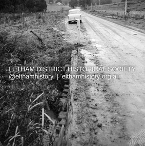
 Eltham District Historical Society Inc
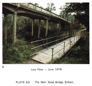
Work on paper (Sub-Item) - Photograph, Main Road Bridge, Eltham low flow of Diamond Creek, June 1979
Colour photograph.Main Road Bridge, Eltham low flow of Diamond Creek with wooden pedestrain bridge constructed over the creek as a continuation of the walking and biking trail, June 1979diamond creek, eltham, bridge, main road, pedestrain bridge, trail -
![Newspaper Clipping - Digital Image, Bridge-over-rail job to cost $254,000, 1974 [Main Street Greensborough], 24/09/1974](/media/collectors/4f729f5697f83e03086015b8/items/5eb5f55721ea671f1807c4cf/item-media/5eb5f5e021ea671f18088f90/item-fit-380x285.jpg) Greensborough Historical Society
Greensborough Historical SocietyNewspaper Clipping - Digital Image, Bridge-over-rail job to cost $254,000, 1974 [Main Street Greensborough], 24/09/1974
In 1974 the proposed road over rail bridge in Main Street Greensborough was estimated to cost $254,000. The reconstruction of the bridge was necessary for the duplication of the rail line between Macleod and Greensborough.News clipping, black and white text. hurstbridge rail line, greensborough station, main street greensborough -
 Ballarat Tramway Museum
Photograph - Digital image, Wal Jack, 19/06/1955 12:00:00 AM
Yields information the reconstruction of the Canadian Creek Bridge in 1955.Digital image from the Wal Jack Ballarat Album of No. 32 at Canadian Creek bridge in Barkly St, Mt Pleasant during the reconstruction of the bridge. Shows the new concrete base for the track in position. Photo dated 19-6-55 and shows the reconstruction work in progress. Tram was isolated to enable the service in Barkly St during the reconstruction of the Canadian Creek bridge during June-July 1955, see Reg Item 5155, 5157 as well and 5301, 5302 and 5305 and 7735. See image i2 for rear of photograph. See image i3 for hi res scan of print. See image i4 for hi res scan of negativeOn rear in ink "SEC Ballarat No. 35 east of creek, No. 32 concrete slabs for tram track placed across new box girders, Barkly St Ballarat East 19-6-55." In top right hand corner is Wal Jack stamp with number T179 written in.trams, tramways, mt pleasant, canadian creek, barkly st, bridges, tram 32 -
 Melbourne Tram Museum
Photograph - Black and White photographs and digital images, Victorian Railways, c1926
.1 - Black and White photo of W 324 passing under the rail over bridge in Racecourse Road Newmarket between July 1925 and Nov. 1929. Tram was converted to a W2 in November 1929. The Doutta Galla Hotel in the background. On the left of the bridge is Newmarket Station and on the right of the photo is the fence of the stockyards. The bridge has an advert for Wolfes Schnapps and Blue? Label Tea. On the embankment is a sign for Life Guard Life Insurance? A lady is waiting at the tram stop. The photo is part of the VR Advertising series, made to show advertisers where signs could go. image i2 - cropped image showing the tramcar by itself. .2 and .3 - Z3 class 209 in about the same position, with a large KIA motor vehicle advertisement. The yellow crash beams and truck parking bay are a result of too many large trucks hitting the bridge. Photo by Warren Doubleday 26/4/2021On rear in ink "ADV 202"trams, tramways, newmarket, racecourse road, flemington, w class, tram stops, advertisements, z3 class, tram 324, tram 203 -
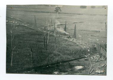 Orbost & District Historical Society
black and white photograph, 1916
This photograph shows the pile drivers at work in the construction of the viaduct across the Snowy River flats. The Snowy River Floodplain Railway Bridges, two sequential and exceptionally long and low timber railway bridges on the Snowy River floodplain just west of Orbost, were built in 1916, and provided the original terminus point for the Bairnsdale-Orbost railway. The bridges are 770 metres and 183 metres long respectively. The shorter bridge is of uniformly 4.57 metre timber-beam construction, and has a sweeping curve in its deck. The longer bridge has a combination of 4.57 metre and 6.1 metrespans, and two 3.66 metre spans. The bridges are constructed from 'Southern Mahogany', Eucalyptus Botryoides, which grew along the coast east of Bairnsdale. The Snowy floodplain bridges were initially built in the context of an early twentieth-century interest in American-style 'Developmental Railways', designed to open remote areas to closer settlement, even if that meant running at a loss. The line was closed in August 1987. (information from Victorian Heritage Database)This item is associated with the history of the Orbost-Bairnsdale railway line and therefore reflects the role that the rail line played in the social and economic history of Orbost.A black / white photograph of the farming flats at Orbost during the construction of the East Gippsland railway.orbost-railway east-gippsland-railway viaduct-orbost transport railway -
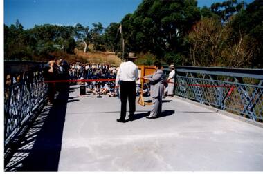 Greensborough Historical Society
Photograph - Digital Image, Anne Paul, Opening of restored Old Lower Plenty Bridge 2001, 14/03/2001
The opening of the restored Old Lower Plenty Bridge, opened on 14/03/2001 by the Minister for Environment and Conservation Sherryl Garbutt MLA and Mayor of Banyule Cr Dale Peters. The project was jointly funded by Banyule Council and Parks Victoria. The restored bridge is the oldest remaining bridge in the former Shire of Eltham and forms part of the Plenty River Trail.Digital copy of colour photographlower plenty, lower plenty bridge, sherryl garbutt, dale peters, banyule council, parks victoria -
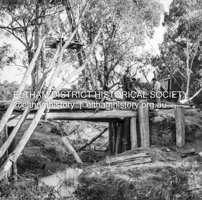
 Eltham District Historical Society Inc
Negative - Photograph, J.A. McDonald, One Tree Hill Road Bridge, Christmas Hills, 2 July 1962
One Tree Hill Road Looking south 2/7/62 The bridge was destroyed by bushfires 15-16 January 1962. A temporary bridge was set up to the east sideRecord of various Shire of Eltham infrastructure works undertaken during the period of 1952-1962 involving bridge and road reconstruction projects, sometimes with Eltham Shire Council Project Reference numbers quoted. It was during this period that a number of significant improvements were made to roads and new bridges constructed within the shire that remain in place as of present day (2022). In many situations, the photos provide a tangible visible record of infrastructure that existed throughout the early days of the Shire. The album was put together by or under the direction of the Shire Engineer, J.A. McDonald.1962-07-02, bridge construction, christmas hills, infrastructure, shire of eltham, victorian bushfires - 1962, bush fires, one tree hill road, property damage -
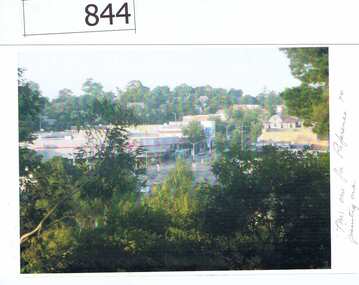 Greensborough Historical Society
Photographs, Photographs by Maria Barbaro, 2010c
Maria Barbaro is a Greensborough artist. These photographs were taken as studies for her paintings. includes Greensborough Hotel, Bridge and pine, Main Street from Delfin Crescent, Old bridge.Colour photographs, digital prints.Name of photographer on back of photos.maria barbaro, greensborough -
 Ballarat Heritage Services
Photograph - Colour, Hoskin's Ointment
Hoskin's ointment for blight, inflammation, ad all other affections of the eyes. Sole Agents Cornell and King 47 Bridge St Ballarat.hoskin's ointment, cornell and king, chemistry -
 Kew Historical Society Inc
Photograph - Removal of the horse tram line in Riversdale Road, Hawthorn, E.J. Dower, c.1916
One of a series of photographs, taken by Edgar James Dower in the second decade of the twentieth century. Born and raised in Olinda, his family later moved to Surrey Hills. He worked as an adult as a clerk in the city office of the Metropolitan Gas Company, and in his role as a 'collector', he was able to photograph scenes including the construction of tramlines and associated buildings in Kew, Hawthorn, Camberwell and Surrey Hills. Later he established a real estate agency with his brother - the E.J. Dower Real Estate Agency, Dandenong Office.The image is an historically significant record of the development of transport infrastructure which was used to connect Victorians in the first two decades of the twentieth century. This development resulted from increases in population and the consequent extension of Melbourne's suburbs. The photographs, both individually and collectively, richly detail the labour of workers and the tools and machinery used to create and extend Melbourne's tram network in the years preceding and during World War 1.Digital copy of an original mounted photograph of the removal of the horse tram tracks in Riversdale Road, Hawthorn, in preparation for laying the new electric tramline.Annotated verso: "Pulling up Hawthorn horse tram line in Riversdale Road, which ran from Hawthorn Bridge to Auburn Road"theme --- travelling by tram, theme -- connecting victorians by transport and communications, trams -- boroondara (vic.), horse tram -- hawthorn (vic.), riversdale road -
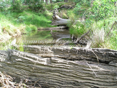 Eltham District Historical Society Inc
Photograph, Fay Bridge, Old timbers in the Diamond Creek at Hurstbridge, 27 February 2018
Just downstream from the bridgefay bridge collection, diamond creek (creek), hurstbridge, 2018-02-27 -
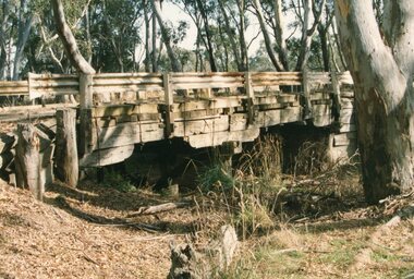
 Eltham District Historical Society Inc
Negative - Photograph, J.A. McDonald, Pinnacle Lane, Steels Creek, Sep. 1955
The old bridge looking downstream Record of various Shire of Eltham infrastructure works undertaken during the period of 1952-1962 involving bridge and road reconstruction projects, sometimes with Eltham Shire Council Project Reference numbers quoted. It was during this period that a number of significant improvements were made to roads and new bridges constructed within the shire that remain in place as of present day (2022). In many situations, the photos provide a tangible visible record of infrastructure that existed throughout the early days of the Shire. The album was put together by or under the direction of the Shire Engineer, J.A. McDonald.1955-09, pinnacle lane, steels creek, bridge construction, infrastructure, shire of eltham -
 Eltham District Historical Society Inc
Negative - Photograph, J.A. McDonald, Pinnacle Lane, Steels Creek, Sep. 1955
The old bridge looking eastwardsRecord of various Shire of Eltham infrastructure works undertaken during the period of 1952-1962 involving bridge and road reconstruction projects, sometimes with Eltham Shire Council Project Reference numbers quoted. It was during this period that a number of significant improvements were made to roads and new bridges constructed within the shire that remain in place as of present day (2022). In many situations, the photos provide a tangible visible record of infrastructure that existed throughout the early days of the Shire. The album was put together by or under the direction of the Shire Engineer, J.A. McDonald.1955-09, pinnacle lane, steels creek, bridge construction, infrastructure, shire of eltham -
 Eltham District Historical Society Inc
Negative - Photograph, J.A. McDonald, Healesville-Yarra Glen Road, c.1957
Bridge over Long GullyRecord of various Shire of Eltham infrastructure works undertaken during the period of 1952-1962 involving bridge and road reconstruction projects, sometimes with Eltham Shire Council Project Reference numbers quoted. It was during this period that a number of significant improvements were made to roads and new bridges constructed within the shire that remain in place as of present day (2022). In many situations, the photos provide a tangible visible record of infrastructure that existed throughout the early days of the Shire. The album was put together by or under the direction of the Shire Engineer, J.A. McDonald.infrastructure, shire of eltham, bridge construction, healesville-yarra glen road, 1957, long gully, healesville, long gully creek, old healesville road, jackson & dethridge, new zealand insurance co. ltd., public risk claim -
 Eltham District Historical Society Inc
Photograph, Russell Yeoman, Yarra Glen Road Bridge over Watsons Creek, Kangaroo Ground, c.1970, 1970c
Concrete bridge built in the 1920s.Roll of 35mm black and white negative film, 4 of 7 stripsIlford HP4bridge, bridges, watsons creek, eltham-yarra glen road, yarra glen road, kangaroo ground -
 Stawell Historical Society Inc
Photograph, Salt Creek Bridge 1993 -- Coloured
Salt Creek Bridge 1993stawell -
 Stawell Historical Society Inc
Photograph, Mokepilly Bridge 1908 -- Postcard
Mokepilly Bridge 1908 Postcardstawell -
 Wonga Park Community Cottage History Group
Photograph (Item) - Black and White, Wonga Park: Old Jumping Creek Bridge, c. 1931
Old Jumping Creek BridgePhoto is named 14880026.jpg on CD -
 Eltham District Historical Society Inc
Photograph, Fay Bridge, Wattletree Road Bridge, Eltham, c.Jan. 1990
Shows Eltham Council sign notifying temporary closure of the bridge 19 Feb to 27 April 1990 for redecking. Illustrates the timber decking of the bridge and pedestrian footbridge extension on southern side.fay bridge collection, 1990-01, wattletree road bridge -
 Eltham District Historical Society Inc
Album - Photograph, J.A. McDonald, Eltham-Diamond Creek Road, Sep. 1959
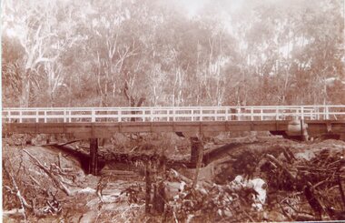
Bridge over Diamond Creek Diamond Creek abutment September 1958 Bridge construction Eltham-Diamond Creek road over the Diamond Creek (Wattletree Road), Eltham, Sept 1959Record of various Shire of Eltham infrastructure works undertaken during the period of 1952-1962 involving bridge and road reconstruction projects, sometimes with Eltham Shire Council Project Reference numbers quoted. It was during this period that a number of significant improvements were made to roads and new bridges constructed within the shire that remain in place as of present day (2022). In many situations, the photos provide a tangible visible record of infrastructure that existed throughout the early days of the Shire. The album was put together by or under the direction of the Shire Engineer, J.A. McDonald.infrastructure, road construction, shire of eltham, bridge construction, bridge, diamond creek (creek), eltham, eltham north, glen park bridge, wattletree road bridge -
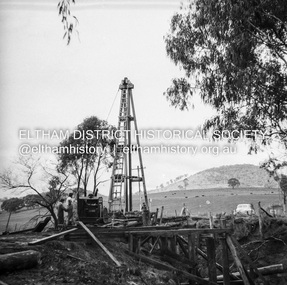
 Eltham District Historical Society Inc
Negative - Photograph, J.A. McDonald, Eltham-Diamond Creek Road, May 1958
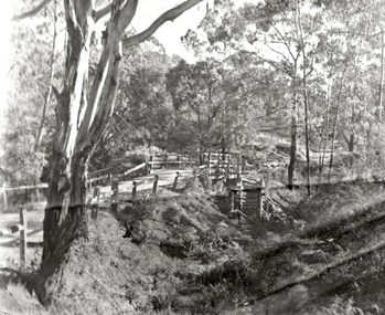
Bridge over Diamond Creek Pile driving Diamond Creek pier Bridge construction Eltham-Diamond Creek road over the Diamond Creek (Wattletree Road), Eltham, May 1958Record of various Shire of Eltham infrastructure works undertaken during the period of 1952-1962 involving bridge and road reconstruction projects, sometimes with Eltham Shire Council Project Reference numbers quoted. It was during this period that a number of significant improvements were made to roads and new bridges constructed within the shire that remain in place as of present day (2022). In many situations, the photos provide a tangible visible record of infrastructure that existed throughout the early days of the Shire. The album was put together by or under the direction of the Shire Engineer, J.A. McDonald.infrastructure, shire of eltham, 1958-05, bridge construction, wattletree road bridge -
 Warrnambool and District Historical Society Inc.
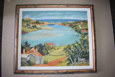
Framed Paintings, 1 The Frame Shop, Fairfield, Melbourne .2 Kardinia Picture Framing, Geelong, 1Warrnambool Botanical Gardens .2 Hopkins River, Warrnambool, 1953
These two works of art are by Dr Don Edgar, a sociologist, educator and author. He taught sociology at Stanford University, the University of Chicago, Monash University and La Trobe University and was the founding Director of the Australian Institute of Family Studies. In the 1950s Dr Edgar was a student at Warrnambool High School and these works of art were produced at that time. For a school project he researched the early history of the Warrnambool Art Gallery and some of its collection, dating from the 19th century. In 2019 he published a book, ‘Art For the Country’, the story of Victoria’s regional art galleries and the book includes information on the founding and the later history of the Warrnambool Art Gallery.These works of art are of interest as they were painted by Dr Don Edgar, a noted academic and author today and a former resident of Warrnambool. The two works of art also have historical interest as they depict Warrnambool scenes painted over 60 years ago. .1 An art work (oil on artboard) – the Warrnambool Botanical Gardens with bridge and reflections, a gum tree and a poplar tree, all in green and orange tonings. The wooden frame has a light varnish with gold and white trim .2 An art work (oil on artboard) – multi-coloured view of the mouth of Hopkins River with the Hopkins River bridge, Lyndoch bungalow and boathouse. The frame is wooden with a mottled varnish and a white insert edging. .1 Don Edgar 1953 Don Edgar 1953 (High School Student) .2 D.E. 53 Don Edgar 1953 (High School Student) dr don edgar, sociologist, author and educator, warrnambool art gallery, history of warrnambool