Showing 25660 items
matching plenty-township-estate
-
 Eltham District Historical Society Inc
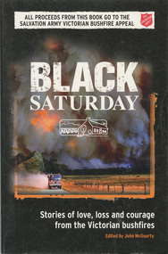
Book, Black Saturday : Stories of love, loss and courage from the Victorian bushfires edited by John McGourty, 2009
The Black Saturday bushfires were a series of bushfires that ignited or were burning across the Australian state of Victoria on and around Saturday, 7 February 2009 and were Australia's all-time worst bushfire disasters. Contributions from reporters and photographers from News Limited. The book is a collection of individual stories, featuring deeply personal contributions from: people directly affected by the bushfires, their friends and relatives; the people who came to their aid - fire fighters, doctors, nurses and wildlife rescuers; accounts from journalists on the scene; and those involved in coordinating the response. Arranged town-by-town, with introductions detailing the scope and impact of the fires on each community. Contents: Kilmore East & Wandong - Strathewen & Kinglake West - St Andrews & Steels Creek - Kinglake - Flowerdale - Marysville--Gippsland -Beechworth & Mudgegonga - the lost ( listing those who perished ) - map of tragedy. Proceeds from the sale of each book was given to the Salvation Army Victorian Bushfire Appeal.SoftcoverYarra Plenty Regional Library identification sticker with name, number and bar code ISBN 9780732290108strathewen, st andrews, black saturday, fires -
 Greensborough Historical Society
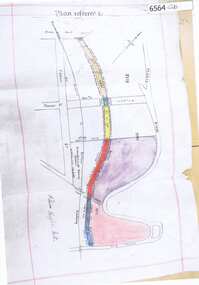
Map, Poulter Avenue transverse, 1900 c
This is a survey of land acquired from William Haylock Poulter for the construction of Poulter Avenue. Includes area of River Estate and part of Poulter Reserve, Carter Street, Flintoff Street and Plenty River.1 p. photocopy of traverse survey printed in colourSigned by William Haylock Poulterpoutlter avenue greensborough -
 Greensborough Historical Society
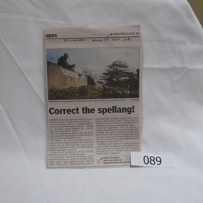
Newspaper clipping, Correct the spellang!, 22/06/2011
McLaughlins Lane was named after Michael McLaughlin who settled in the area in 1840. An office error misspelt the name to McLaughlans Lane and family members have approached council to correct the mistake.Shirley Black was a foundation member of the Greensborough Historical Society and a long time resident of the area.Newspaper cutting from Diamond Valley Leader 22/6/2011, p16. Photograph of Shirley Black who was campaigning to have McLaughlans Lane Plenty returned to its original spelling of Mclaughlins LaneDate written in pen.shirley black, mclaughlin family, mclaughlans lane plenty, street names -
 Greensborough Historical Society
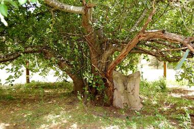
Photograph - Digital Image, Batman Apple Tree 2018, 2018_
The Batman apple tree is located on the Plenty Trail north of Greensborough. The tree dates from the mid 1800s and is said to have been purchased from John Batman's estate after his death.Digital copy of colour photographbatman apple tree, john batman, plenty river trail -
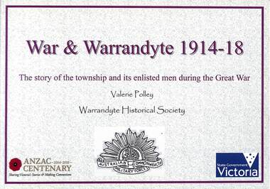 Ringwood and District Historical Society
Book, Valerie Polley, War & Warrandyte 1914-18 - Valerie Polley, 2016
The story of the township and its enlisted men during the Great War, by Valerie Polley, Warrandyte Historical Society.This book has been compiled from posters exhibited in the Warrandyte Historical Society's exhibition entitled War & Warrandyte 1914-18, made possible by a grant through the Anzac Centenary Community Grants (Veterans Fund) from the Victorian Government and the Victorian Veterans Council. -
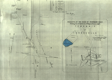 Federation University Historical Collection
Plan, A.M. Howitt, Nuggets at the Head of Ironbark Gully, Tarnagulla, c1907
Plan showing part of the township of Tarnagulla, and the Ironbark Gully area including Western Reef and Creek's Hill.tarnagulla, ironbark gully, western reef, creek's hill, cgt -
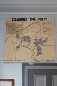 Coal Creek Community Park & Museum
Map of Korumburra's Coal, Korumburra Coal Fields, 1910
8513.1 - Map of coal fields, township, roads, creeks, railways and boreholes in the Korumburra area. Painted on Canvas -
 Bendigo Historical Society Inc.
Map - KANGAROO FLAT, 27/.01/1932
Map: Township of Kangaroo Flat, Parish of Sandhurst, County of Bendigo ( number 148 in Map Cupboard 1)map, bendigo, township, kangaroo flat, parish of sandhurst, county of bendigo -
Bendigo Historical Society Inc.
Map - KOOYOORA, July 23rd 1857
Map: The Township of Kooyoora and suburban allotments in the Parish of Kingower. This plan has been applied to a newer backingmap, township, kooyoora, allotments, parish of kingower -
Bendigo Historical Society Inc.
Map - HARCOURT, No date visible
Map: Township of Harcourt, Parish pf Harcourt, County of Talbot, (number 265 in map cupboard 1)map, talbot, township, harcourt -
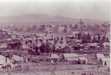 Clunes Museum
Photograph
BLACK AND WHITE PHOTOGRAPH OF CLUNES TOWNSHIP, TAKEN FROM LESLIE STREET EAST, OFF SMEATON ROAD.METHODIST & PRESBYTERIAN CHURCHES IN CENTRE TAKEN FROM LESLIE ST. EAST OF SMEATON ROAD NOTE WESLEYAN CHURCH HAS SPIRElocal history, photography, photographs, clunes township -
Canterbury History Group
Map - Logan Estate, Canterbury
Real estate advertisement distributed by Sinclair & Company of a reproduction of a historical map of the Logan Estate and a short history on the reverse side.canterbury, logan estate, canterbury road, prospect hill road, marlowe street, logan street, canterbury railway station, logan family, sinclair & company, clairmont estate, molesworth street -
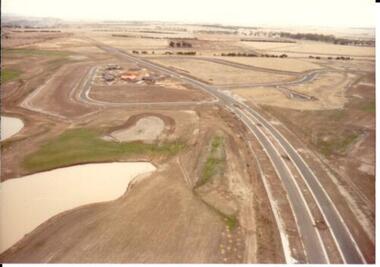 Hume City Civic Collection
Photograph, c 1978
On 4th August 1978 the construction of the Goonawarra Estate commenced. The estate was formerly known as the Goonawarra Farm and overlooked the Sunbury Township and the Jacksons Creek Valley. Plans for the development included a golf course, houses and community and recreational facilities. The golf course opened in 1980 and the housing construction continued throughout the last two decades of the twentieth century and into the twenty first century.A coloured aerial photograph of a display village area under construction. Two lakes are on the LHS of the photograph and Francis Boulevard is in the foreground and the middle distance.goonawarra golf club, goonawarra farm, goonawarra housing estate, housing developments, sharkey, robert b., kilkenny homes, australian ideas homes pty.ltd., glamor homes, craftsmen homes., villa bella homes, george evans collection -
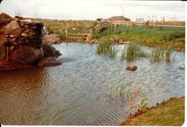 Hume City Civic Collection
Photograph, c 1978
On 4th August 1978 the construction of the Goonawarra Estate commenced. The estate was formerly known as the Goonawarra Farm and overlooked the Sunbury Township and the Jacksons Creek Valley. Plans for the development included a golf course, houses and community and recreational facilities. The golf course opened in 1980 and the housing construction continued throughout the last two decades of the twentieth century and into the twenty first century.A coloured photograph of the reflecting pool at the entrance of the Goonawarra Golf Club. The surrounding area has been landscaped and a display home is in the distance.goonawarra golf club, goonawarra farm, goonawarra housing estate, housing developments, sharkey, robert b., kilkenny homes, australian ideas homes pty.ltd., glamor homes, craftsmen homes., villa bella homes, george evans collection -
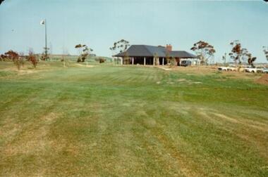 Hume City Civic Collection
Photograph, c 1978
On 4th August 1978 the construction of the Goonawarra Estate commenced. The estate was formerly known as the Goonawarra Farm and overlooked the Sunbury Township and the Jacksons Creek Valley. Plans for the development included a golf course, houses and community and recreational facilities. The golf course opened in 1980 and the housing construction continued throughout the last two decades of the twentieth century and into the twenty first century.A coloured photograph of the clubhouse at the Goonawarra Golf Course taken from the 10th fairway. Parked cars are visible on the RHS of the photograpg and there is a row of gum trees behind the clubhouse.goonawarra golf club, goonawarra farm, goonawarra housing estate, housing developments, sharkey, robert b., kilkenny homes, australian ideas homes pty.ltd., glamor homes, craftsmen homes., villa bella homes, george evans collection -
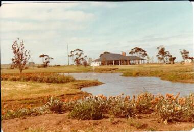 Hume City Civic Collection
Photograph, c 1978
On 4th August 1978 the construction of the Goonawarra Estate commenced. The estate was formerly known as the Goonawarra Farm and overlooked the Sunbury Township and the Jacksons Creek Valley. Plans for the development included a golf course, houses and community and recreational facilities. The golf course opened in 1980 and the housing construction continued throughout the last two decades of the twentieth century and into the twenty first century.A coloured photograph of the clubhouse at Goonawarra Golf Course as seen from the 10th green. A small white van is parked ouitside the building. There is a line of trees behind the clubhouse.goonawarra golf club, goonawarra farm, goonawarra housing estate, housing developments, sharkey, robert b., kilkenny homes, australian ideas homes pty.ltd., glamor homes, craftsmen homes., villa bella homes, george evans collection -
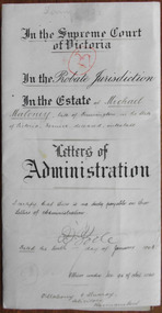 Warrnambool and District Historical Society Inc.
Document - Michael Maloney Letters of Administration 1907, 1908
Tait collection: item 54 of 62 This document gives the details of the Letters of Administration of Michael Maloney who died intestate in 1907. He was aged 64. In this document he was described as a farmer from Dennington, near Warrnambool but a Michael Maloney is listed in 1866 as a butcher and this may be the same person or a member of his family. Michael Maloney left real estate to the value of £160 and personal estate to the value of £38. This was passed over to the son, Michael Maloney, a railway employee of Flemington, Melbourne. The lawyers involved in drawing up this document were O’Mahony and Murray who had legal offices in Warrnambool in the late 19th and early 20th centuries. Con O’Mahony had established his practice in Warrnambool in the 1880s under the name of Klingender, O’Mahony and Murray and by the 20th century this was operating under the name of O’Mahony and Murray. Con O’Mahony died in 1920. This document was then passed down to successive lawyers occupying the legal premises in Kepler Street where it was located in 2014 (the former premises of the legal firm of Mackay Taylor). This document is of some interest as it gives details of the Letters of Administration of Michael Maloney, a farmer in the Dennington area in the late 19th and early 20th centuries. It will be useful for researchers. This is a cream-coloured piece of parchment paper folded in two to make four pages. The front page has ruled black margins and there is handwritten material on two of the pages in brown ink. These two pages also have printed italic script on them in black ink with the handwritten material inserted in the spaces left. A seal of the Supreme Court of Victoria is attached with a green ribbon and there is a red stamp of the Master in Equity of the Supreme Court on the first page. The document is somewhat stained. The document gives the details of the Letters of Administration of Michael Maloney of Dennington who died in 1907. In the Supreme Court of Victoria in the Probate Jurisdiction in the Estate of Michael Maloney, late of Dennington, in the State of Victoria, farmer, deceased, intestate. Letters of Administration.o’mahony and murray,, warrnambool solicitors, michael maloney 1907, warrnambool, michael maloney dennington 1907, michael maloney, tait collection -
 Whitehorse Historical Society Inc.
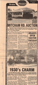
Newspaper, Mitcham Road auction, 01/04/1984,Nunawading
Advertisement for the sale of two homesAdvertisement for the sale of two homes, 265 Mitcham Road, Mitcham and 534 Mitcham road, Mitcham a 1930s timber home. Agent, drakes real estate. Photographs. Cutting from Nunawading Gazette, 18th April, 1984.Advertisement for the sale of two homesmitcham road, mitcham, no. 534, mitcham road, mitcham, no. 265, houses, drake & co. -
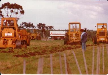 Hume City Civic Collection
Photograph, 1/08/1978
On 4th of August 1978 work began on the construction of the Goonawarra Estate on land that was the former Goonawarra Farm which overlooked the town of Sunbury abnd the Jacksons Creek valley. Plans for the new development included a golf course, houses, community and recreational facilities.The golf course openrd in 1980 and housing construction continued throughout the last two decades of the twentieth century and into the twentieth first century.A coloured photograph of the first sod being turned at the Goonawarra Estate. Four large pieces of earth-moving machinery and a large semi-trailer are in picture. A man is standing in the foreground.goona warra golf club, goonawarra farm, goonawarra housing estate, housing developments, sharkey, robert b., killkenny homes, australian ideas homes pty.ltd., craftsmen homes., glamor homes, villa bella homes, george evans collection -
Kew Historical Society Inc
Plan - Burke Road Junction Estate, East Kew, 1940
Subdivision plans and real estate flyers/brochures reveal a number of aspects of urban development and history. The Kew Historical Society's collection of these plans, as well as advertisements extracted from magazines, cover key aspects of community development and architectural history of Kew and Kew Eat as well as surrounding suburbs. While most of the plans in the collection were gifted to the Society by the former City of Kew, a number of other plans and advertisements have been donated by individuals, of which this is an example.Original 4-page bifold brochure advertising the Burke Road Junction Estate in Kew East. Advertised for sale in 1940, the estate comprised 16 'Central Allotments' fronting High Street, Kilby Road, and Glass Street. Pages 1 & 4, the front and back covers, includes a panoramic photograph of the junction which features a number of shops still extant, but also with buildings long demolished and redeveloped. These include the petrol station and the dairy on the southeast and southwest corners of Burke Road and High Street/Doncaster Road. The dairy includes a statue of a cow on its roof. Pages 2 & 3 include a detailed plan of the estate. subdivisions -- kew east (vic.), burke road junction estate -
 Surrey Hills Historical Society Collection
Book, Medlow Garden Survey and Landscape capability study 1983, Oct-83
Includes: Plan of Subdivision, Detailed plan, map of garden, Auctioneer's plan for 1854 sale, Botanical plan of Medlow & Landscape history notes. Full title : Medlow Garden survey and landscape capability survey. A report for the National Trust of Australia (Victoria) A report detailing the landscape survey of Medlow Garden estate. Includes landscape history, cultural significance, particulars about vegetarian, garden, rehabilitation and plans.A report detailing the landscape survey of Medlow Garden estate. Includes landscape history, cultural significance, particulars about vegetarian, garden, rehabilitation and plans. 38 p illland surveys, medlow garden, bismark estate, rosalie estate, warrigal road, surrey hills, bismarck avenue, warwick avenue, t p payne, (mr) hugh glass, boroondara, (maj.) (mr) - cairncross, (mrs) mary jane cairncross, (dr)(mr) richard joseph bull, (mrs) catherine grace bull, (miss) norma bull, (mr) ronald richard bull, medlow, house names, (mr) rex swanson, landform australia -
 Warrnambool and District Historical Society Inc.
Booklet, Port Fairy, Early to mid 20th century
This is a typed copy of William Earle’s History of Port Fairy written in 1896. The history is of interest to researchers and the information contained in it has been updated and extended by historians in recent times. William Earle, a printer with a business in Port Fairy came to Australia with his parents, William and Mary, in 1854. He was a Councillor and Mayor and was heavily involved in local community affairs. He died in 1902 at the age of 51. His 1896 history won a prize in a local Industrial Exhibition and was widely acknowledged as an important primary source of early Port Fairy history. This booklet is of minor interest as it is a copy of a 19th century Port Fairy history book and is not a rare item. It is retained as it came from the Baulch collection of documents and belonged to David Baulch of Koonongal Estate, HwakesdaleThis is a booklet of 59 pages of typed material bound into a brown cardboard cover with metal screws. The pages are typed on one side only and have a black border around all sides.David Baulch Koonongal Estate Hawkesdale 3287baulch family, dunmore and rose park, history of warrnambool -
 Whitehorse Historical Society Inc.
Furniture - Chiffonier
Chiffonier was used for storage in a workshop and rescued and restored by George Cox and K. Huntsman a descendant of original ownerCedar chiffonier with raised backboard to three sides of top. Raised centre panel with pointed top to doors. Matching round wooden knobs. Small plaque on top left hand side showing original owner and dateFrom the Estate of Benjamin Huntsman 1821-1886furniture, domestic -
 Bendigo Historical Society Inc.
Document - BUSH COLLECTION: COLLECTION OF CORRESPONDENCE RE BUSH FAMILY ESTATE, 1920-25
Collection of approx 17 pieces of typewritten correspondence re Bush family estates and 3 pieces re Jane Bush estate.person, family, bush collection (family, bendigo, bush collection, collection, business, retail, commerce -
 Whittlesea Historical Society Inc.
Document, Australian Silver Presentation Trowel
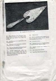
The foundation stone of a new bridge over the Plenty River at Morang (now Mernda) was laid by Mrs. John Wilton of Wilton Vale, in August 1866. The silver trowel was presented to Mrs. Wilton by Moses Thomas, chairman of the road board. The bluestone bridge was officially opened by Moses Thomas on the 12th of February 1867.The location of the silver trowel in this rare image is unknown.A4 single page (double sided) with image and a list of items numbered 461 - 495.Item 486. Important Australian Silver Presentation Trowel., inscribed "Presented to Mr John Wilkin of Wilkin Dale Morang on the Occasion of the Laying of the Foundation Stone, the Bridge of the Plenty River at the Junction of the Parishes of Morang and Yan Yean by the Morang District Road Board, August 1866, Fine Engraved Scroll Decorated Border, Turned Ivory Handle, Maker R. R. Illustrated Page 27.silver trowel, morang bridge, mernda bridge, john wilton, wilton family, moses thomas, wilton vale -
 Whittlesea Historical Society Inc.
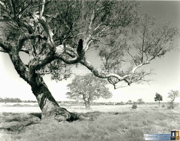
Photograph, Evan Meades, Mill Park, red gum tree, Sep 1988
One of a series of photographs taken in 1988-1989 around the Shire of Whittlesea by Evan Meades.Print copy of a photograph"Northern fringe of Mill Park looking Sth. 500 metres in from Plenty Road Sept 88"evan meades collection, plenty road, mill park, mill park estate, plenty road mill park, red gum tree -
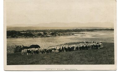 Orbost & District Historical Society
black and white photograph, first half 20th century
This photograph is of Captain's Point, Mallacoota.This is a pictorial record of Mallacoota in the first half of the 20th century. It shows the young township.A small black / white photograph / of a flock of sheep on a hilltop with the ocean behind them. A township can be seen in the background.on front - " Captain's Point Mallacoota"mallacoota-captains-point -
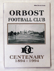 Orbost & District Historical Society
book, Orbost Football Club Centenary 1894 - 1994, 1994
This book was made for celebration of the centenary of the Orbost Football Club in 1994. The Orbost football club players were known as the Busters and wore green and gold guernseys. An Orbost football team has participated in the East Gippsland League since the early 20th century. In 2003 in response to a dwindling population, the Snowy Rovers and Orbost Football Clubs were driven to merge into the Orbost Snowy Rovers.Orbost Football Club through its many changes has always been an important social fabric of the Orbost community. Sport is often regarded as an important part of life in rural Australia, contributing to community identity, sense of place, social interaction and good health.A soft covered book of white with large green and gold print on the cover. There is a photograph of a football ovel with a township behind it.orbost-football-club-centenary recreation sport football -
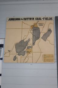 Coal Creek Community Park & Museum
Jumbunna Coal Field Map, Jumbunna and Outtrim Coal Fields, 1910
8512.1 - Map of coal fields, Township, roads rail lines and creeks in the Jumbunna and Outtrim areas. Painted on canvas. -
Port Melbourne Historical & Preservation Society
Plan - Township of Sandridge, 1855
COPYRIGHT PUBLIC RECORDS OFFICE Plan of the Township of Sandrdge 1855 - copy from Public Record Office 1978local government - municipal district of sandridge, town planning, j jones