Showing 3762 items
matching surveyed
-
 Federation University Art Collection
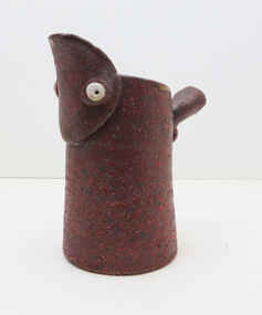
Ceramic - Artwork - Ceramics, Bridget Bodenham, [Dining Setting] by Bridget Bodenham, 2006
Bridget BODENHAM Bridget Bodenham has a Diploma of Arts (Ceramics) from the University of Ballarat (now Federation University. In 2006 she received an Emerging Artist grant from the Australia Council for the Arts and was also part of Craft’s annual graduate survey exhibition, Fresh!. She works full time making ceramic serving ware, tableware, utensils and jewellery as well as planter pots and flower vases. The majority of her work is designed to be used and enjoyed. Bridget feels a connection to her surrounding bushland landscape and interprets the tones and textures in her work. She takes great care in creating each piece by hand and firing them up to three times in her large gas kiln. Each firing is totally unique resulting in one off pieces. Bridget Bodenham was a finalist in the Bombay Sapphire Design Discovery Award (2008) for a series of ceramic mortars and pestles, and received an Honourable Mention in the Mino International Ceramic Award, Japan. Bridget aims to create a sense of curiosity and reflection in form and function. She hopes her work delights and engages the owners hands and heart into everyday activities. This piece won the SMB DVC Visual Arts Acquisition Award, 2006Mould made dining setting consisting of plate, two bowls and three eating utensils. Makers mark on versoceramics, bridget bodenham, artwork, alumni, dvc aquisition award -
 Federation University Art Collection
Ceramic, 'Shino Milk Jug' by Bridget Bodenham, 2007
Bridget BODENHAM Bridget Bodenham has a Diploma of Arts (Ceramics) from the University of Ballarat (now Federation University. In 2006 she received an Emerging Artist grant from the Australia Council for the Arts and was also part of Craft’s annual graduate survey exhibition, Fresh!. She works full time making ceramic serving ware, tableware, utensils and jewellery as well as planter pots and flower vases. The majority of her work is designed to be used and enjoyed. Bridget feels a connection to her surrounding bushland landscape and interprets the tones and textures in her work. She takes great care in creating each piece by hand and firing them up to three times in her large gas kiln. Each firing is totally unique resulting in one off pieces. Bridget Bodenham was a finalist in the Bombay Sapphire Design Discovery Award (2008) for a series of ceramic mortars and pestles, and received an Honourable Mention in the Mino International Ceramic Award, Japan. Bridget aims to create a sense of curiosity and reflection in form and function. She hopes her work delights and engages the owners hands and heart into everyday activities. The Federation University Art Collection features over 2000 works and was listed as a 'Ballarat Treasure' in 2007.Small, thrown ceramic vessel / jug with handle and lip. art, artwork, bridget bodenham, ceramics, alumni -
 Eltham District Historical Society Inc
Photograph, Liz Pidgeon, Heritage Excursion; The 1901 Eltham Railway Walk, 3 May 2014
Newsletter No. 216, May 2014 May Excursion – The 1901 Eltham Railway Walk The railway from Heidelberg to Eltham was opened in 1902. Over the previous year railway construction cut a curving swathe through Josiah Holloway’s 1851 Little Eltham subdivision. The survey plans for the railway show the owners and occupiers of land within Little Eltham affected by the railway alignment and for some distance each side. The plans show houses and other buildings but development at that time was rather sparse. Copies of these plans from the State Library of Victoria collection have been provided to the Society by Alan Sheehan. For our walk on 3rd May we intend to follow the railway from the Eltham Station to Ryans Road, which was the boundary of the adjoining Montmorency Farm. The return will be by way of nearby streets. Along the way we will discuss the details shown on the railway plans as well as more recent railway documents and photographs. At the conclusion and if time permits we can inspect the historical display at the Eltham Station. The walk is about 3 km in length and will take about 2.5 hours. It will start at 2 pm at the Eltham Railway Station car park (east/Main Road side) (Melway Ref. 21 J5).Born Digitalheritage excursion, activities, eltham district historical society, eltham railway station, eltham library, trestle bridge -
 Glen Eira Historical Society
Album - Album page, Carnegie Methodist Church, Neerim Road, Circa 1972
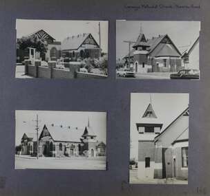
This photograph is part of the Caulfield Historical Album 1972. This album was created in approximately 1972 as part of a project by the Caulfield Historical Society to assist in identifying buildings worthy of preservation. The album is related to a Survey the Caulfield Historical Society developed in collaboration with the National Trust of Australia (Victoria) and Caulfield City Council to identify historic buildings within the City of Caulfield that warranted the protection of a National Trust Classification. Principal photographer thought to be Trevor Hart, member of Caulfield Historical Society. Most photographs were taken between 1966-1972 with a small number of photographs being older and from unknown sources. All photographs are black and white except where stated, with 386 photographs over 198 pages. From Victorian Heritage Database citation for HO47 Uniting Church, 254 Neerim Road https://vhd.heritagecouncil.vic.gov.au/places/42432 (as at 28/10/2020) The former Methodist church (now Uniting church) complex at 252-54 Neerim Road, Carnegie, consists of the original timber church of 1886, the present brick Arts and Crafts influenced church of 1914, designed by A. Phipps Coles, the timber hall attached to the original church, built during the interwar period and the present brick hall of 1933, designed by J.F. Snell. From Victorian Heritage Database citation for HO47 Uniting Church, 254 Neerim Road https://vhd.heritagecouncil.vic.gov.au/places/42432 (as at 28/10/2020) The complex has aesthetic, historical and social significance. Its aesthetic value is derived from the extreme simplicity of the original church and the highly picturesque, eclectic, Arts and Crafts influenced character of the main church and hall. Its historical value rests in the early date of the original building and the manner in which the remaining buildings are representative of the principal period of settlement of the locality. The social significance derives from the use of the site as a place of worship since the commencement of the closer settlement of Carnegie from as early as 1886. Page 146 of Photograph Album with four photographs (3 landscape, 1 portrait) of Carnegie Methodist Church, Neerim Road.Handwritten: Carnegie Methodist Church Neerim Road [top right] / 146 [bottom right]trevor hart, neerim road, carnegie methodist church, church, toolambool road, wesleyan methodist church, breslin gallery, anthony breslin, 1910's, american romanesque, spire, half gabled tower, art, gallery, cafe, arched doorways, red brick, uniting church, carnegie, arts and craft style, a p coles, a coles, j f snell, j snell, halls -
 Glen Eira Historical Society
Album - Album page, Rose Craddock, Rose Craddock Avenue, Circa 1972
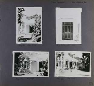
This photograph is part of the Caulfield Historical Album 1972. This album was created in approximately 1972 as part of a project by the Caulfield Historical Society to assist in identifying buildings worthy of preservation. The album is related to a Survey the Caulfield Historical Society developed in collaboration with the National Trust of Australia (Victoria) and Caulfield City Council to identify historic buildings within the City of Caulfield that warranted the protection of a National Trust Classification. Principal photographer thought to be Trevor Hart, member of Caulfield Historical Society. Most photographs were taken between 1966-1972 with a small number of photographs being older and from unknown sources. All photographs are black and white except where stated, with 386 photographs over 198 pages. From Victorian Heritage Database citation for H0589 Rosecraddock 4-10 Craddock Avenue and 2-8 Keverell CAULFIELD NORTH https://vhd.heritagecouncil.vic.gov.au/places/35279 as at (30/10/2020) "Rosecraddock" is regionally important as a surviving large villa from the early Victorian (1850's) period, offering insight into the lifestyles of the privileged in Caulfield at that time. Its importance is enhanced through its long association with the Langdon family and, in particular, Henry Joseph Langdon, founder of H.J. Langdon and Company, China merchants. Victorian Heritage Database HO16 Rosecraddock, 2-8 Keverell Road & 4-10 Craddock Avenue Caulfield North https://vhd.heritagecouncil.vic.gov.au/places/35279 (as of 17/02/2021) A single storeyed stuccoed villa with west facing facade consisting of a parapeted and recessed central section with hipped slate roof and timber posted verandah with cast iron lace. Projecting pavilions have bayed windows and a secondary wing runs north with angled corners and prominent chimney stack. The front entrance is situated at the north end of the central section and is given emphasis by a small hip roof and false pediment to the verandah. Outbuildings include the timber stables with characteristic hay loft gablet and fretted barges to the south-east. Rear additions in brick and timber are of an early date and utilitarian in character. Also see https://vhd.heritagecouncil.vic.gov.au/places/277 for Significance Statement for the H0589 Victorian Heritage Register listing.Page 174 of Photograph Album with four photographs of Rose Craddock.Handwritten: "Rose Craddock" Rose Craddock Ave. top right] / Neg 197 Nov 1972 [under top left photo] / Neg 209 Nov 1972 [under top right photo] / Neg 196 Nov 1972 [under bottom left photo] / Neg 195 198 Nov 1972 [under bottom right photo] / 174 [bottom right]trevor hart, chimneys, porch, rose craddock, rosecraddock, ringwood, 1850's, henry joseph langdon, h.j. langdon, h.j. langdon and company, china merchants, rosecraddock place, slate roof, return verandah, decorative brackets, keverell road, caulfield north, early victorian style, protruding bay windows, cast iron work, rendered walls, entrances, mansions, craddock avenue -
 Glen Eira Historical Society
Album - Album page, Rose Craddock, Rose Craddock Avenue, Circa 1972
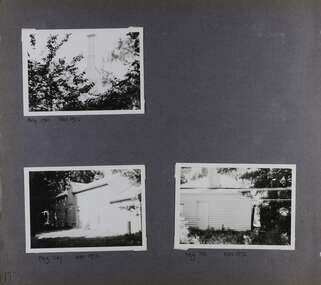
This photograph is part of the Caulfield Historical Album 1972. This album was created in approximately 1972 as part of a project by the Caulfield Historical Society to assist in identifying buildings worthy of preservation. The album is related to a Survey the Caulfield Historical Society developed in collaboration with the National Trust of Australia (Victoria) and Caulfield City Council to identify historic buildings within the City of Caulfield that warranted the protection of a National Trust Classification. Principal photographer thought to be Trevor Hart, member of Caulfield Historical Society. Most photographs were taken between 1966-1972 with a small number of photographs being older and from unknown sources. All photographs are black and white except where stated, with 386 photographs over 198 pages. From Victorian Heritage Database citation for Rosecraddock https://vhd.heritagecouncil.vic.gov.au/places/35279 as at (30/10/2020) City of Glen Eira Heritage Listing HO16 "Rosecraddock" is regionally important as a surviving large villa from the early Victorian (1850's) period, offering insight into the lifestyles of the privileged in Caulfield at that time. Its importance is enhanced through its long association with the Langdon family and, in particular, Henry Joseph Langdon, founder of H.J. Langdon and Company, China merchants.There is a separate statement of significance at https://vhd.heritagecouncil.vic.gov.au/places/277 for H0589 Rosecraddock 2-8 KEVERELL ROAD and 4-10 CRADDOCK AVENUE CAULFIELD NORTH - Victorian Heritage RegisterPage 175 of Photograph Album with three photographs of Rose Craddock.Handwritten: Neg 190 Nov 1972 [under top left photo] / Neg 207 Nov 1972 [under bottom left photo] / Neg 191 Nov 1972 [under bottom right photo] / 175 [bottom left]trevor hart, chimneys, porch, rose craddock, rosecraddock, 1850's, henry joseph langdon, h.j. langdon, h.j. langdon and company, china merchants, rosecraddock place, slate roof, return verandah, decorative brackets, cast iron lacework, keverell road, caulfield north, early victorian style, mansions, protruding bay windows, cast iron work, outbuildings, craddock avenue, gardens -
 Glen Eira Historical Society
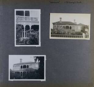
Album - Album page, Glenmoore, St George's Road, Circa 1972
This photograph is part of the Caulfield Historical Album 1972. This album was created in approximately 1972 as part of a project by the Caulfield Historical Society to assist in identifying buildings worthy of preservation. The album is related to a Survey the Caulfield Historical Society developed in collaboration with the National Trust of Australia (Victoria) and Caulfield City Council to identify historic buildings within the City of Caulfield that warranted the protection of a National Trust Classification. Principal photographer thought to be Trevor Hart, member of Caulfield Historical Society. Most photographs were taken between 1966-1972 with a small number of photographs being older and from unknown sources. All photographs are black and white except where stated, with 386 photographs over 198 pages. From Victorian Heritage Database citation for HO59 Glenmoore, 1 St Georges Road Elsternwick https://vhd.heritagecouncil.vic.gov.au/places/35202 as at 30/10/2020 "Glenmoore" is locally significant as a surviving mid nineteenth century villa residence in the then fashionable bi-chromatic brick form. It is also important as the home of Hugh Moore who built several shops in nearby Glen Huntly Road and which remain as important contributors to the architectural character of the Elsternwick Shopping Centre.Victorian Heritage Database citation HO59 Glenmoore, 1 St Georges Road Elsternwick https://vhd.heritagecouncil.vic.gov.au/places/35202 An imposing two storeyed villa in bichrome brick with two storeyed timber posted verandah, coupled with cast iron lace frieze, spandrels and central tympanum enrichment. The hipped roof is in slate and has a prominent crean1 brick chimney stack forming part of the facade. Openings are flat arched although the entrance is round arched with a fan light. The south elevation has bayed windows. Two storeyed hip roofed additions are sympathetic and attached on the north side and at the rear. Inside, the staircase and stained glasswork with initials "HM" and family coat of arms are important surviving elements. INTEGRITY: Good, timber outbuildings of an early date, mature and spacious front garden includes early palm trees. Alterations include reconstruction of facade verandah including tiled pavement and front door on east side. Interior has a high level of integrity. Original grounds included adjoining "Carramar".Page 178 of Photograph Album with three photographs of Glenmoore, St Georges Road. Handwritten: "Glenmoore" 1 St George's Road [top right] / 178 [bottom right]trevor hart, chimneys, porch, mansion, slate roof, return verandah, stained glass, cast iron frieze, glenmoore, 1860's, hugh moore, glenmoore estate, double storey, elsternwick shops, st george's road, thomas watts, elsternwick, victorian style, protruding bay windows, cast iron work, bi-chromatic bricks, gardens, balconies, moore's buildings, glen huntly road, stairs, house names -
 Glen Eira Historical Society
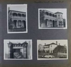
Album - Album page, Presentation Convent, Sandham Street, Circa 1972
This photograph is part of the Caulfield Historical Album 1972. This album was created in approximately 1972 as part of a project by the Caulfield Historical Society to assist in identifying buildings worthy of preservation. The album is related to a Survey the Caulfield Historical Society developed in collaboration with the National Trust of Australia (Victoria) and Caulfield City Council to identify historic buildings within the City of Caulfield that warranted the protection of a National Trust Classification. Principal photographer thought to be Trevor Hart, member of Caulfield Historical Society. Most photographs were taken between 1966-1972 with a small number of photographs being older and from unknown sources. All photographs are black and white except where stated, with 386 photographs over 198 pages. From Victorian Heritage Database citation for Presentation Convent, 28 Sandham Street https://vhd.heritagecouncil.vic.gov.au/places/35476 (as at 1/11/2020) - HO61 City of Glen Eira The "Presentation Convent" is locally significant as a substantial late Victorian villa residence in Elsternwick and for its more recent role in the educational and spiritual lives of the community. Other names: formerly "Cromarty School for Girls", "Chiselhurst". (National Trust entry on VHD mentions an association with Horatio Beauchamp without elaborating.) Currently this is St Joseph's Primary School.From Victorian Heritage Database citation for Presentation Convent, 28 Sandham Street https://vhd.heritagecouncil.vic.gov.au/places/35476 (as at 1/11/2020) - HO61 City of Glen Eira A substantial two storeyed stuccoed asymmetrical Italianate villa residence, representative of its period, with two storeyed cast iron verandah and projecting facetted bay with trabeated treatment to the ground floor and round arched upper level windows with distinctive moulds.Page 184 of Photograph Album with one portrait and three landscape photographs of Presentation Convent, Elsternwick. One is an internal fireplace and its mantelpiece.Handwritten: Presentation Convent, Sandham Street [top right] / CHISEL HURST / CROMARTY [under bottom right photo] / 184 [bottom right]trevor hart, chimneys, porch, school, education, presentation sisters, catholic girls college, balcony, verandah, presentation convent, sandham street, victorian villa residence, cast iron frieze, cast iron columns, protruding bay, bay window, 1880's, late victorian, cromarty, chiselhurst, chisel hurst, horatio beauchamp, elsternwick, victorian style, cast iron work, catholic church, mansions, house names, gardens, mantelpieces, fireplaces, streetscapes, cars, cromarty school for girls, st joseph's primary school, st josephs primary school -
 Mission to Seafarers Victoria
Artwork, other - Art installation, Dagmar Udhe, Leap of the Heart: Ultramarine perspex oval shape by Dagmar Udhe, 1998
See document 1507Information for the brochure (http://www.artdes.monash.edu.au/globe/issue8/tbtitle.html) Construction in Process VI The Bridge, Melbourne Event: March 21-31 1998 Exhibition April 1-30 1998 During Construction in Process (CIP) III at Lodz, Poland in 1991, Emmett Williams and other participating artists initiated the idea of a biannual "performance" of their project in different cities and sites around the world. In the first instance, CIP was a response to the strictures of museum contained commodification of art practices and the dissolution of communism. And with this agenda in mind, their events affirm the active participation of international artists with local infrastructure and site specific materials. The organisation of the 1998 CIP in Melbourne, titled "The Bridge", took Richard Thomas, Katherine Armstrong, Gail Davidson and the legion of others over two years of dedication. And they brought off one of the most open-ended, logistically challenging conceptual events this metropolis has witnessed. The following photo essay provides a personal survey of the "The Bridge", as I saw it transpire around me. German artist Dagmar Udhe created several art installation in Swanson Dock and the Mission. This plaque was placed either in the dome or outside the dome. It may have been forgotten or left intentionally by the artist.PerformanceUltramarine ovoid shaped perspex plaque attached to the wall in the entrance of the Mission (Flinders Street).art installation, dagmar udhe, cultural events, artwork-paintings -
 City of Moorabbin Historical Society (Operating the Box Cottage Museum)
Newsletter, City of Moorabbin Historical Society Apr 2009, April 2009
The City of Moorabbin Historical Society was formed c 1960 by a group of Moorabbin residents who were concerned that the history of the area should be preserved. A good response to a call for items related to the historical area of Moorabbin Shire brought donations of a wide variety of artefacts which are now preserved by the current members of CMHS at Box Cottage Museum . Helen Stanley, Secretary of CMHS, began producing a Newsletter for members in April 2007 to provide current information and well researched items of historical interest.Helen Stanley has produced a bi-monthly Newsletter, 2007 - 2013, for the members of the City of Moorabbin Historical Society that contains well researched interesting historical items, notification of upcoming events, current advice from Royal Australian Historical Society , Museums Australia Victoria and activities of Local Historical Societies. The Newsletter is an important record of the activities of the CMHS.2 x A4 paper printed on 4 sides Issue 11 of the bi-monthly, City of Moorabbin Historical Society Newsletter produced by Society member and Secretary, Mrs Helen Stanley in April 2009. Notice that Mr Travis Sellars, Friends of Cheltenham and Regional Cemeteries, will talk about ‘The Tragic 20’s’ at the meeting April 26th . Volunteers are needed to show visitors around on Open Days each month and a Roster will be made on April 26th . Suggestions are requested for the Community Grant Application to be submitted by CMHS. Historical details are condensed from ‘ The Living Harvest’ by W.T Dobson, describing the establishment of St. Peter’s Catholic School East Bentleigh 1865 on land donated by Fred Quinn , in Centre Road, East Brighton ( East Bentleigh). A photo copy of Parts of Country Portion 39 of Dendy’s Special Survey or Brighton Estate showing the Land Sales of Lot 2, & 3 North Road and Jasper Road 1841 – 1869. Interesting note on the origin of ‘Jasper Road’. 3 photocopied photographs of St Peter’s School building 1903, School Children at East Brighton Railway Station, 1903, A Lorry in the parade 1903. CITY of MOORABBIN HISTORICAL SOCIETY / APRIL 2009 NEWSLETTERcity of moorabbin historical society, stanley helen, dobson w.t., melbourne, moorabbin, brighton, friends of cheltenham and reional cemeteries, cheltenham, ormond, bentleigh, market gardeners, irish immigrants c1850pioneers, early settlers, moorabbin shire, box cottage museum, port phillip bay, brighton estate, jasper road ormond, east boundary road brighton, dendy’s special survey 1851, point nepean road, south road brighton, thomas street brighton, north road brighton, county of bourke, box h., box william, parish of moorabbin, parish of prahran, markets, shingle roof, weather-board, mr., mckinnon, were jonathan, niall rev. fr. patrick, quinn fred, elsternwick, catholic church directory 1878, hibernian society melbourne, brady peter., kennedy mr., boland mr., leary mr., gahan mr., archbishop carr, rev. fr. gough., presentation convent gardenvale, sister mary vincent, charlston john, bavarian dress band, hales jasper -
 Federation University Historical Collection
Newspaper, Australasian Sketcher, 30 June 1884 to 01 November 1888, 1883 and 1888
Two copies of the Austakasian Sketcher with Pen and Pencil .1) 30 June 1884 Includes articles on Archbishop Moran, Children's Hospital, Sherbourne Sheppard obituary, the Tichborne case Includes images of the Most Reverand P.F. Moran, Catholic Archbishop of Sydney, New Sandridge Dock, Cricketing news from home, sketches from the Children's Hospital, View of Napier New Zealand, F. Mills New Warehouse Launceston, Grace Park .2) 01 November 1888 Articles include: Australian animals Images include: Cadbury's cocoa advertisement, A Flemington Picture, Railway Surveying Wangaratta to Mansfield, H.M.S. Nelson Leaving Sydney, New Prince's Bridge, Wilson Hall, Victoria before gold, Fawkner's First Printing Office, Government House Melbourne, Sandridge, Hobson's Bay, Old Supreme Court Melbourne, Melbourne Town Hall, Ballarat in the 50, Geelong in 1840, Ballarat Church of Engand Cathedral, Melbourne Exhibition Building, Flemington Racecourse, the Australian Club, Sir Anthony Musgrave, Fisheries Court at the Centennial Exhibition; Professor Neumayer, Antarctic Exploration, Melbourne Town Hall Organmelbourne international exhibition -
 Warrnambool and District Historical Society Inc.
Documents, Late 20th, early 21st centuries
These ten documents (maps, plans, photographs) mostly come from the Warrnambool City Council and most contain information on sub-divisions and titles of properties in areas around the Central Business District of Warrnambool. The dates range from 1986 to 2006. These maps, plans and photographs are of some interest as they give historical details of subdivisions in Warrnambool and date from the late 20th century. .1 This is a laminated map of the boundaries of Local Governments in Victoria. It is Sheet I of 2 and has red and blue pencil markings and black boundary markings. .2 This is a copy of a plan of a survey in black and white markings on paper. .3 This is a plan of the title details of Section 19 Warrnambool. It has black printing on buff-coloured paper. .4 This is a plan of the allotments in part of the Central Business District of Warrnambool. It is printed in black and white. .5 This is a 2006 coloured aerial photograph of the harbour at Warrnambool – Breakwater etc. .6 This is a 2006 coloured aerial photograph of the Lake Pertobe area in Warrnambool .7 This is a coloured aerial photograph of Warrnambool’s streets over-stamped with road numbers in large blockings. .8 This is a plan showing the title details of Section 11 in Warrnambool. It has black printing on buff-coloured paper. .9.1 This is a plan of sub-divisions in parts of Crown Allotments 38 & 39 in Warrnambool. It has green, pink and yellow markings with black printing. .9.2 This is a plan of the sub-divisions in parts of Allotments 38 & 39 in Warrnambool. It has pink, yellow and blue markings with black printing. It is somewhat faded. warrnambool c.b.d. maps and plans, history of warrnambool