Showing 123949 items matching "main-road"
-
 Eltham District Historical Society Inc
Slide - Photograph, Main Yarra Trail, Lower Plenty, c.Aug. 1990
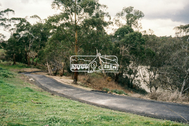
Part of a presentation, "Roads and Byways of the Shire of Eltham", by Russell Yeoman to the 12 September 1990 Society meeting. Slides shown included copies of old photos and recent images ranging from the suburban streets of Eltham and Montmorency to the mountain roads of Kinglake. In the byways category are views of some iof the Shire's bicycle paths including then recently completed sections of the Main Yarra Trail at Lower Plenty.35mm colour positive transparency (1 of 37) Mount - Agfachrome Agfa CS System black 8 dotsinfrastructure, bonds road, lower plenty, main yarra trail, roads, yarra river -
 Eltham District Historical Society Inc
Slide - Photograph, Main Yarra Trail, Lower Plenty, c.Aug. 1990
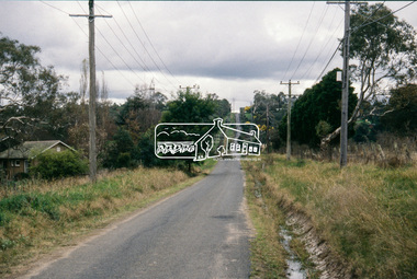
Part of a presentation, "Roads and Byways of the Shire of Eltham", by Russell Yeoman to the 12 September 1990 Society meeting. Slides shown included copies of old photos and recent images ranging from the suburban streets of Eltham and Montmorency to the mountain roads of Kinglake. In the byways category are views of some iof the Shire's bicycle paths including then recently completed sections of the Main Yarra Trail at Lower Plenty.35mm colour positive transparency (1 of 37) Mount - Agfachrome Agfa CS System black 8 dotsinfrastructure, bonds road, lower plenty, roads -
 Whitehorse Historical Society Inc.
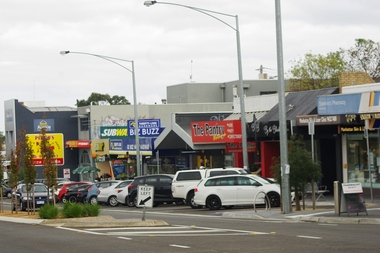
Photograph, Blackburn Road/Canterbury Road, Blackburn South, 2012
See NP4006Coloured photograph of the Blackburn Road and Canterbury Road intersection. Cars heading east on Canterbury Road towards Vermont.blackburn road, blackburn south, canterbury road -
 Ballarat Heritage Services
Photograph - Colour, Clare Gervasoni, Hepburn Bushfire site, 2019, 2019
Colour photographs of the site of the 2019 Hepburn Bushfire on Mannings Road / Mannings Hill, Elevaited Plans. The red line in the foreground of the photos is the remains of fire retardant from aircraft.hepburn bushfire, mannings road bushfire, mannings hill bushfire, bushfire, fire retardant, elevaitd plains -
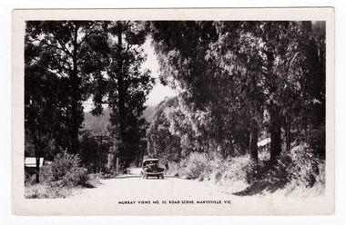 Marysville & District Historical Society
Postcard (item) - Black and white postcard, Murray Views, Murray Views No. 30. Road Scene, Marysville, Vic, Post 1929
An early black and white photograph of a road scene taken in Marysville, Victoria.An early black and white photograph of a road scene taken in Marysville, Victoria. This postcard was produced by Murray Views in Gympie, Queensland as a souvenir of Marysville."Kooringa"/ Monday Dear Mother/ Just a short note/ to say I am well & having a/ good holiday. Went on the/ Cumberland Valley trip last/ week - was very enjoyable./ To-day we are doing the Eildon/ Weir trip - all day. Have had/ fairly good weather - was able/ to go out every day. Will/ ring you later in the week/ about meeting me. If the/ strike is still on will probably/ get you to order a taxi for/ me. Lots of love/ Margaretmarysville, victoria, postcard, murray views, souvenir -
 Ringwood and District Historical Society
Flyer, Executor's Auction Subdivision Advertisement, Lilydale Road and Oban Road, Ringwood East, Vic. - 1937
Single page advertisement for Executor's Auction of land in Ringwood East on Saturday, May 29, 1937 with locality map showing 26 building sites for auction highlighted in brown, and brief summary of local services available. Subdivision includes Old Lilydale Road, Joseph Street, Dynes Street, Albert Street (later Wyrunga Street), Carcoola Road, and Mount Dandeong Road. (Carcoola Road incorrectly shown as Oban Road on the subdivision plan). Auctioneer - C.E. Carter, (Phone Ringwood 24. -
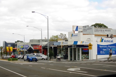 Greensborough Historical Society
Photograph - Digital image, Marilyn Smith, Watsonia Road pharmacy, 2016, 24/05/2016
Watsonia Road Pharmacy, Watsonia 2016. The strip is managed by the Watsonia Traders Association.Digital copy of colour photograph.watsonia, watsonia road -
 Whitehorse Historical Society Inc.
Article, 5 Longland Road, Heatherdale, 1984
Auction Notices of 100 year old Home,Auction Notices of 100 year old Home, 5 Longland Road, Heatherdale, on 10th March 1984.Auction Notices of 100 year old Home, longland road, heatherdale, no. 5 -
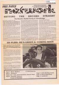 Greensborough Historical Society
Newspaper, Network Community Newspaper, Network. November 1992, 1992_11
Free newspaper circulating in Eltham, Diamond Valley and Whittlesea. Main article: Setting the record straight: the Bourke/Burke family of Hurstbridge12 p. Black and white text and photographs hurstbridge, burke family, patrick bourke -
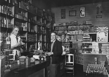 Stawell Historical Society Inc
Photograph, Illig's Grocery Shop in Main Street Stawell
Two men in a grocery store. Left to right Stan Illig & Jim Illig, Illigs shop was at 103 Main Street Stawell 1938 -
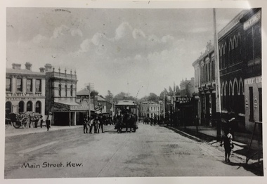 Kew Historical Society Inc
Postcard, Main Street, Kew
Image copied from older postcard (c.1890-1900) showing horse drawn vehicles and a horse tram. Since then, the southern side of the street has been widened. Businesses identified in the photograph include the Ryan's Council Family Hotel, the Greyhound Hotel, the Clifton Hotel, the ES&A Bank and Jellis' Bakery. Black & white photograph of a postcard showing Main [High] Street, Kew looking south west showing horse drawn tram centre.Reverse - "High St Kew looking down from Post Office to Kew Junction"horse tram kew, clifton hotel - kew junction, ryan's council family hotel kew, horse tram - kew (vic), kew junction -
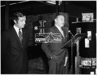 Eltham District Historical Society Inc
Photograph, Opening of Eltham Library, 17 Aug 1971
Opening of Eltham Library by The Hon. R.J. Hamer, E.D., M.P. (right) and Cr. G.C. Dreverman. The Eltham Branch of the Heidelberg Regional Library Service was opened on 17 August 1971 by Victoria’s Chief Secretary R. J. Hamer. The library was designed by the firm Leith and Bartlett and was the southern wing of the Shire of Eltham Offices in Main Road Eltham. Visitors entered a “book plaza” which embodies the display techniques of a bookshop. Through this area was located a quieter area for reference and the more “purposeful” reader. The library was opened as part of the Shire of Eltham’s centenary celebrations. The library and Shire Offices were demolished exactly 25 years later in 1996. The current library was opened in 1994.This photo forms part of a collection of photographs gathered by the Shire of Eltham for their centenary project book, "Pioneers and Painters: 100 years of the Shire of Eltham" by Alan Marshall (1971). The collection of over 500 images is held in partnership between Eltham District Historical Society and Yarra Plenty Regional Library (Eltham Library) and is now formally known as 'The Shire of Eltham Pioneers Photograph Collection.' It is significant in being the first community sourced collection representing the places and people of the Shire's first one hundred years.Digital imagesepp, shire of eltham pioneers photograph collection, shire of eltham, shire of eltham centenary, eltham library, opening day, cr. g.c. dreverman, the hon. r.j. hamer, rupert hamer -
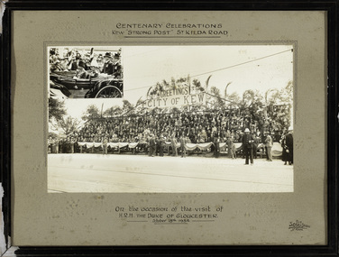 Kew Historical Society Inc
Photograph, The Sears Studio, Centenary Celebrations : Kew "Strong Post" St Kilda Road, 1934
Cr. W.D. Vaughan in 'Kew's Civic History' (1960) records that: "In connection with the Melbourne Centenary Celebrations in 1934, the Kew Council decided to organise a strong post as an appropriate gesture of welcome to H.R.H. the Duke of Gloucester. Also that the municipality be represented by a symbolic floral float in the Royal pageant. This was a striking entry and won first prize, and evoked much comment on account of its originality and truly Australian motif." The photograph of the Kew Strong Post was once part of the Municipal Collection of the former City of Kew and was presented to the Kew Historical Society before the move from the Walpole Street (Kew) Town Hall to new Civic offices in Charles Street in 1971.Historic photograph of participation by the City of Kew in celebrations for a royal visitFramed and glazed photograph on its original inscribed mount and original frame of the Kew "Strong Post" in St Kilda Road on the occasion of the visit to Melbourne of the Duke of Gloucester. The photograph has two components, at the upper left is a photo of the royal carriage while the man photo shows the people of Kew on a decorated 'Strong Post' on St Kilda Road, along which the procession progressed. T"Centenary Celebrations / Kew "Strong Post" St Kilda Road / On the occasion of the visit of / H.R.H. The Duke of Gloucester / October 18th 1934."royal visits - melboure - 1934, duke of gloucester, kew (vic.) — municipal collection -
Whitehorse Historical Society Inc.
Document, Electing members of the District Road Board, 1862
Copy from Ivan Southall''s 'A Tale of Box Hill', public meeting for the election of members of the Nunawading District Road Board, for fixing the rate for the current year and appointing auditors.Copy from Ivan Southall''s 'A Tale of Box Hill', public meeting for the election of members of the Nunawading District Road Board, for fixing the rate for the current year and appointing auditors. Extract from Road Board minute book, 10 Sept 1862.Copy from Ivan Southall''s 'A Tale of Box Hill', public meeting for the election of members of the Nunawading District Road Board, for fixing the rate for the current year and appointing auditors.local government, nunawading district roads board -
 Ringwood and District Historical Society
Photograph, Laying pipeline near Mt. Dandenong Road, in Whitehorse Road, Ringwood (undated)
Written on back of photograph, "Laying pipeline near Mt. Dandenong Road, in Whitehorse Road". -
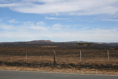 Sunbury Family History and Heritage Society Inc.
Photograph, Rosa McCall, Riddell Road, February 2014
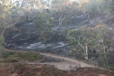
In February 2014 severe grassfires blazed across the land north of Sunbury from the Calder Highway across Riddell Road and on to Clarkefield and beyond and caused damage to the Bendigo Railway line. This image was taken about a week later along Riddell Road and looking SW to Red Rock across the skyline.This grass fire caused much damage across a large area north of Sunbury and beyond.A coloured photograph of an open landscape that has been extensively burnt after grassfires.grass fires, riddell road, red rock, sunbury -
 Greensborough Historical Society
Photograph - Digital image, Marilyn Smith, Watsonia Road shopping strip, 2016, 24/05/2016
Watsonia Road shopping strip, Watsonia 2016. The strip is managed by the Watsonia Traders Association.Digital copy of colour photograph.watsonia, watsonia road -
 Greensborough Historical Society
Photograph - Digital image, Marilyn Smith, Watsonia Road shopping strip 2, 2016, 24/05/2016
Watsonia Road shopping strip, Watsonia 2016. The strip is managed by the Watsonia Traders Association.Digital copy of colour photograph.watsonia, watsonia road -
 Greensborough Historical Society
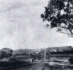
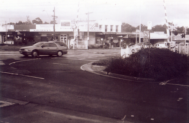
Photograph - Digital image, Unknown Local View Possibly Rosanna Road from Heidelberg or Grimshaw Street to Greensborough, 1925c
Possibly view of Main Road to Greensborough.Digital copy of black and white photograph. -
 Ringwood and District Historical Society
Photograph, View of Glenvale Road, Ringwood. Warnes Road in left background 1964
See Also #25Written on back of photograph, "1964 - View of Glenvale Road. Supplied by Garrett Gundry. Warnes Road in left background. Deep Creek Road in centre background." -
 Whitehorse Historical Society Inc.
Photograph, Railway crossing on Springvale Road, 1/06/2009
One of a collection of photographs taken of the Nunawading Railway Station prior to the lowering of the railway line and building of the new railway station on the western side of Springvale Road so that the Springvale Road Rail Crossing can be eliminated.Black & white photograph of the precinct surrounding the Nunawading Station and the Springvale Road Railway crossing. This photograph is the railway crossing with Springvale Road, Nunawading, taken from the north west corner looking over crossing to some of the Nunawading shops. See NP 3545 to NP3567 for the complete set of photographsnunawading railway station, springvale road nunawading, redevelopment of railway line/springvale road., nunawading recreation centre -
 Ringwood and District Historical Society
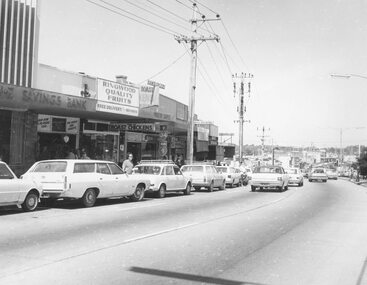
Photograph, Maroondah Highway Central, Ringwood. Main St. shops opp. old Ringwood Town Hall site, 1974
Black and white photograph.Written on rear of backing sheet: "Main St. shops opp. old Town Hall site, 1974". -
 Greensborough Historical Society
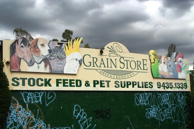
Photograph - Digital Image, Marilyn Smith, Greensborough Grain Store, 183 Para Road. Signs, 06/11/2017
This photograph shows signage at 183 Para Road when the building was used for Greensborough Grain Store.Digital copy of colour photographgreensborough grain store, para road greensborough -
 Greensborough Historical Society
Photograph - Digital Image, Marilyn Smith, Greensborough Grain Store, 183 Para Road. Exterior, 06/11/2017
This photograph shows the exterior of the building at 183 Para Road when it was used for Greensborough Grain Store.In 2017, the Greensborough Grain Store closed its Para Road premises and now trades online.Digital copy of colour photographgreensborough grain store, para road greensborough -
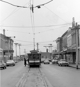 Ballarat Tramway Museum
Photograph - Digital image, Peter Bruce, "No. 30 Main St", 1970s
Yields information about the Main St area.Digital image, black and white, of No. 30 outbound to Mt Pleasant in Main St with a SEC crew member getting off the tram. On the right hand side is a sing for "HUB" and Dennis Swards Upholsterer. Photo taken by Peter Bruce 1970's and 1971, prior to the closure of the Ballarat tramway system. Peter's Title of image: "No. 30 Main St".trams, tramways, main st, mt pleasant, tram 30 -
Whitehorse Historical Society Inc.
Document, 520 Mitcham Road, 2005
Papers relating to objections to development of 520-528 Mitcham Road Mitcham.Papers relating to objections to development of 520-528 Mitcham Road Mitcham. Includes: statement by Neil Edwin Kerby & Margaret Anne Kerby; Title searches for 449 Mitcham Road Mitcham and adjacent properties; plan of 1906 subdivision; ASIC extract of development company organisational details; aerial photos of the area; photographs of nearby properties and of Mitcham Road streetscapes and list of Mitcham objectors. CD copy at NP3771Papers relating to objections to development of 520-528 Mitcham Road Mitcham. mitcham road mitcham, nos. 520-528, kerby, neil edwin, kerby, margaret anne, mitcham road mitcham no. 449, 520 mitcham road pty ltd, listermay nominees pty ltd, land subdivision -
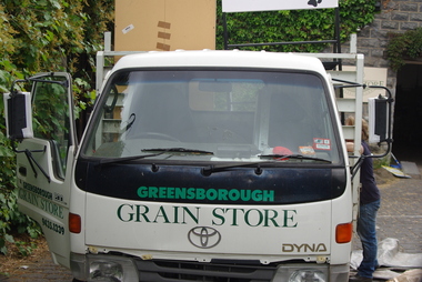 Greensborough Historical Society
Photograph - Digital Image, Marilyn Smith, Greensborough Grain Store, 183 Para Road. Delivery truck, 06/11/2017
This photograph shows delivery truck at 183 Para Road when the building was used for Greensborough Grain Store.In 2017, the Greensborough Grain Store closed its Para Road premises and now trades online.Digital copy of colour photographgreensborough grain store, para road greensborough -
Greensborough Historical Society
Photograph - Digital Image, Marilyn Smith, Greensborough Grain Store, 183 Para Road. Closure notice, 04/10/2017
This Facebook post explains the move by Greensborough Grain Store to close the business at 183 Para Road in 2017.In 2017, the Greensborough Grain Store closed its Para Road premises and now trades online.Digital copy of Facebook postgreensborough grain store, para road greensborough -
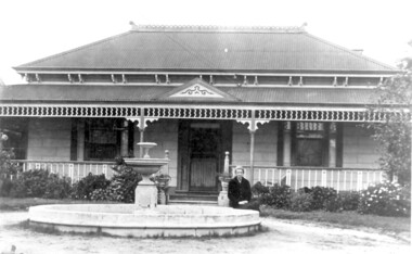 Surrey Hills Historical Society Collection
Photo, 'Spenceycroft', Canterbury Road
The photo is of ‘Spenceycroft’ at 654 Canterbury Road, Surrey Hills. For many years this home was hidden behind a large fence sheltering it from the noise of traffic along Canterbury Road, however it dates back to the very early days of settlement in the Surrey Hills area. Canterbury Road was then known as Delany’s Road. ‘Spenceycroft’ is thought to incorporate part of the original farmhouse built on the site by George Klepper, who planted a vineyard in the area. George’s family was one of a number of German families who settled in Surrey Hills during the later part of the 19th century. Later, the land associated with ‘Spenceycroft’ was worked as a dairy farm by James and Elizabeth Rayment. In recent years 'Spenceycroft' has been sold several times and has become increasingly derelict. Sold again in 2015 when it had become quite derelict, it was demolished and re-developed.A black & white photo of double-fronted Victorian style home with a fountain centre front and low foliage in front of the veranda. A woman is sitting by the fountain. 'spenceycroft', canterbury road, james rayment, elizabeth rayment, george klepper -
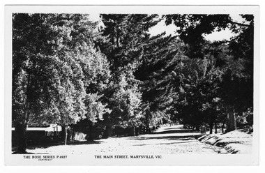 Marysville & District Historical Society
Postcard (Item) - Black and white postcard, Rose Stereograph Company, The Main Street, Marysville, Vic, 1913-1967
A postcard in a series produced by the Rose Stereograph Company in Victoria, Australia as a souvenir of Marysville.An early black and white photograph of the main street in Marysville, Victoria. This is now known as Murchison Street. This postcard was produced by The Rose Stereograph Company as a souvenir of Marysville.POST CARD The "Rose" Series/ De Luxe A Real Photograph/ Produced in Australia Published by The Rose Stereograph Co.,/ Armadale, Victoria.main street, murchison street, marysville, victoria, p. 4927, rose series postcard, postcard, souvenir