Showing 8323 items
matching the bridge
-
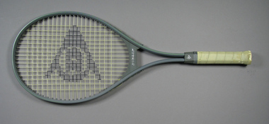 Tennis Australia
Racquet, Circa 1980
A Dunlop X-30' split shaft tennis racquet, with grey plastic bridge. Materials: Metal, Composite Materials, Synthetic material, Ink, Adhesive tape, Nylon, Plastic, Painttennis -
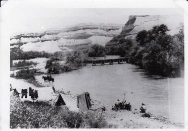 8th/13th Victorian Mounted Rifles Regimental Collection
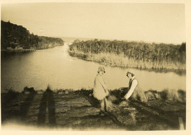
Photograph - 8th LH camped by lake, 1918 circa
The 8th Light Horse Regiment AIF was raised at Broadmeadows Victoria in September 1914 under the command of Lieutenant Colonel Alexander White and formed part of the 3rd Light Horse Brigade. The regiment served at Gallipoli where in a courageous but ill-fated charge at the Nek on 7 August 1915 it suffered horrendous casualties including Lieutenant Colonel White. Rebuilt in Egypt under the command of Lieutenant Colonel Leslie Maygar VC the regiment went on the serve throughout the Middle East Campaign. Colonel Maygar died of wounds at Beersheba when the regiment was attacked by enemy aircraft while waiting to follow up the successful charge of the 4th LH Brigade on 30 October 1917. The 8th Light Horse AIF was disbanded in 1919, but soon after re-raised as the 8th (Indi) Light Horse in the Citizen Military Forces, superseding 16th (Indi) Light Horse.Comparatively rare collection of photographs of 8th Light Horse (AIF) on operations in Egypt and Palestine 1916-1918.Black and White photograph of bivouac beside river. Several soldiers of the 8th Light Horse Regiment AIF, two horses, pontoon bridge, and washing drying on line beside bivouac."Crossing the River Jordan"8th, light horse, wwi, world war one, aif, middle east, jordan -
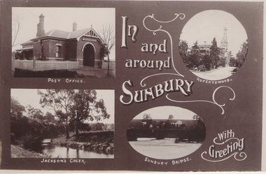 Sunbury Family History and Heritage Society Inc.
Photograph
A post card featuring four were known scenes of Sunbury including the post office, Rupertswood Mansion, Macedon Street Bridge andJacksons Creek. A greeting is also printed on the card.IN/AND/AROUND/SIUNBURY/WITH /GREETINGS -
 Tarnagulla History Archive
Telegram, circa 1862
A large lot of papers, including this and many other telegrams, were apparently found in the ceiling cavity of the Sandy Creek/Tarnagulla Post and Telegraph Office in the later 20th Century, during building works. Donald Clark Collection. Telegram sent from Tarnagulla Telegraph Office from P Macfarlane to Mr I.J. Harcourt, Immigrants House, Princes Bridge, Melbourne. Text reads 'How are Amelia and Amy'. -
Tarnagulla History Archive
Registration of Birth form, 1871
A large lot of papers, including this and many other birth and death registration forms, were apparently found in the ceiling cavity of the Sandy Creek/Tarnagulla Post and Telegraph Office in the later 20th Century, during building works. Donald Clark Collection. Registration of Birth form for: Child's name: William Patterson Date of Birth: 5th Feb, 1871 Place of birth: Arnold's Bridge Father: John Patterson Mother: section lost -
University of Melbourne, Burnley Campus Archives
Newspaper - Newspaper Cutting, The Argus, The Horticultural Society of Victoria, 1869
Copy of article in "The Argus" 13 October, 1869. Description of entering the Gardens from Bridge Road and what could be seen of the new West Orchard, the Ornamental Gardens and the Proving Ground.the argus, gardens, west orchard, ornamental gardens, proving ground, fruit trees -
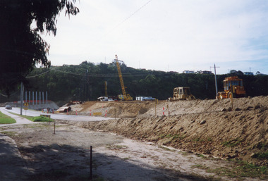 Lakes Entrance Historical Society
Photograph - North Arm Bridge, Davies Judy, 1999
Date made 10 April 1999Colour photograph of the construction of the road approaches and abutments for the new North Arm bridge, earthmoving machinery and crane on southern approach looking towards northern abutment. Lakes Entrance Victoriabridges, machinery, construction, roads and streets -
 Lakes Entrance Historical Society
Postcard - tramline Lake Bunga, 1920
Small format black and white postcard showing a distant view of tramway bridge at Lakes Bunga, Victoria. Two women in foreground, image taken from Bunga Haven guesthouse.bridges, timber industry, waterways, tramline -
 Lakes Entrance Historical Society
Photograph - North Arm Lakes Entrance, 2008
Date made August 2008Colour photograph of North Arm and Cunninghame Arm, taken from Jemmys Point, shows small bridge to Bullock Island, the Seamec educational facility in the background. Lakes Entrance Victoriabridges, fishing industry, islands, waterways, topography -
 Bendigo Historical Society Inc.
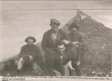
Newspaper - JENNY FOLEY COLLECTION: TOUGH MEN
BHS CollectionBendigo Advertiser ''The way we were'' from 2003. tough men: working on Eddington Bridge, 1929. The man in the centre with a cap on is Jack Allan. The others are unidentified. The clip is in a foldernewspaper, bendigo advertiser, the way we were -
 Melbourne Tram Museum
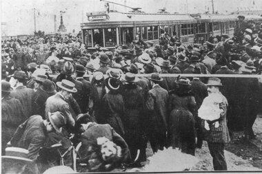
Photograph - Black & White Photograph/s, 6/04/1916 12:00:00 AM
Black and White Photograph of the opening of the Hawthorn Tramways Trust tramway to Princes Bridge 6/4/1916. Shows three bogie trams and the large crowd. Printed on Kodak Paper.On rear in ink a description - see image i2 and KSK number "S-A-1097"trams, tramways, htt, opening, princes bridge, new tramway -
 Melbourne Tram Museum
Negative - Set of 2, Wal Jack, c1940
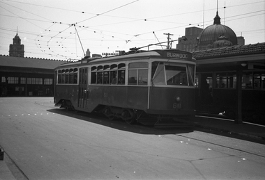
Set of two Black and white negatives by Wal Jack of Y1 611 (Burwood) at Princes Bridge terminus, Batman Ave. Has Flinders St Station in the background. Photo c1940.trams, tramways, y1 class, batman ave, princes bridge, burwood, tram 611 -
 Melbourne Tram Museum
Photograph - Black & White Photograph/s, Tramway Museum Society of Victoria (TMSV), c1975
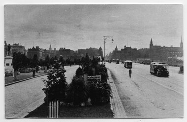
Black & White Photograph by the TMSV Sales of a cable cars and pedestrians crossing Princes Bridge looking back towards the city. The photograph has a satin finish. Two copies held.Has the TMSV Sales stamp on rear.trams, tramways, cable trams, princes bridge -
 Whitehorse Historical Society Inc.
Print - Booklet, Woolies for Britain
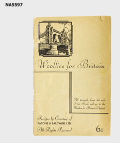
All proceeds from the sale of this book will go to the Woollies for Britain Appeal'Woollies for Britain' booklet Drawing of Tower Bridge on the cover 'Recipes by Courtesy of Patons & Baldwins Ltd" All rights reserved 6d Booklet contains 16 patterns for children's garmentsWoollies for Britainwoollies, ww ii, knitting patterns, recipes, patons & baldwins ltd, housekeeping -
 Buninyong & District Historical Society
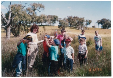
Photograph - Colour photograph of Clarendon State School excursion to Williamson's Creek 1993, Clarendon State School excursion to Williamson's Creek 1993
Colour photo, Clarendon State School excursion to Mineral Springs, Burnt Bridge, Williamson's Creek 1993, last excursion before school closed, led by Ann Beggs Sunterclarendon school, excursion, mineral springs, burnt bridge, williamson's creek -
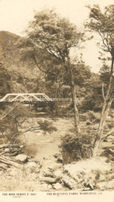 Lakes Entrance Historical Society
Photograph - Post card Rose series 3643 Warburton, Rose Stereographers Armadale Victoria, Yarra River, Warburton Victoria, 1920 - 30 c
The writer of the message on back of card was a Miss Ruth Catt who boarded with the family of Vic and Myrtle Fish of Roadknight St Lakes Entrance in the 1920 - 30 She was a teacher at the Bunga Creek State School East of Lakes Entrance and walked through the bush to schoolSepia toned postcard showing white wooden bridge over Yarra River with hill at back densely wooded shrubbery along river bank and rocky foreground at Warburton VictoriaThe Rose Series P3643 The Beautiful Yarra Warburton Victoriaschool teachers, correspondence -
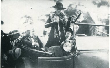 Orbost & District Historical Society
black and white photograph, July 1922
The photograph shows Mrs James Cameron cutting the ribbon at the opening of the Orbost Pile Bridge in 1922. The first bridge was officially opened in August, 1893 (ref. S.R.M. 12.8.1893) by Mrs W. Watt, the mother of Councillor Watt, who presided over the opening of the 1922 bridge. This bridge was extensively damaged when a herd of cattle allegedly stampeded over it causing the cable to snap. Even after repairs it became obvious that a new bridge was needed. This second bridge, was built by the Victorian Railways and the Country Roads Board. Constructed at a cost of 35,000 pounds and used second-hand girders from the Flinders Street- Spencer Street viaduct. On July 4 1922 it was officially opened by Mrs James Cameron. Unfortunately, her husband, who had long championed the building of the bridge so that it would be ready for the railway to continue to the border, was too ill to attend the ceremony. In fact, James Cameron died on July 13 after a long and severe illness (ref. S.R.M. 20.7.1922). There is a section of this ribbon in the collection - Registration No. 366.This item is a pictorial record of a significant event in Orbost's history.A black / white photograph of a lady standing up in a motor vehicle cutting a ceremonial ribbonsnowy-river-bridge-orbost cameron-mrs ceremonies -
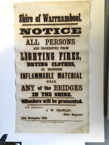 Warrnambool and District Historical Society Inc.
Document, Shire of Warrnambool Fire - Washing-Bridge 1882, 1882
This notice relates to the prohibition of lighting fires,drying clothes or bringing inflamable material near any of the bridges in the shire. Offenders will be prosecuted. With a date of 1882 and the fact that bridges were mostly made of wood, it would have been of concern that the destruction of bridges was not only of great inconvenience but also of considerable expense. But the reality of bridges providing shelter and warmth in the colder months and the ensuring fires and burnt bridges has more than likely precipitated this notice. J W Crawley was shire engineer from 1876 until 1895 and for 10 of those years he trained his son J W Crawley who succeeded his father and served in the position for 40 years.He in turn was succeeded by his son Rolf Crawley in 1935. In 1963 the bridge over the Hopkins Falls at Wangoom was named the Crawley bridge in honour of service to the Shire of Warrnambool by members of the Crawley family. The Shire of Warrnambool was proclaimed in 1863 and covered an area of over 600 square miles. Much of it was incorporated into the Moyne Shire in the 1990's with some being included into the boundaries of City of Warrnambool. This banner is an interesting piece of history. It shows the issues confronting early settlers such as shelter and the chores of daily life but also the importance placed on infrastructure which was slowly taking place around the district. It was in the era of drainage and roadworks and hence bridges were an important part of that infrastructure. The name J W Crawley is one of importance in the Warrnambool district for his service over many years. Rectangular piece of cloth printed in black ink. The back is plain.Shire of Warrnambool By order of J W Crawley Shire Engineer, 13th November 1882. Thos Smith gas Printing Works Koroit Street Warrnambool.warrnambool, shire of warrnambool, bridges of warrnambool shire, j w crawley, warrnambool shire engineer, crawleys of warrnambool -
 Eltham District Historical Society Inc
Album - Photograph, J.A. McDonald, Eltham-Diamond Creek Road, Sep. 1959
Bridge over Diamond Creek From Diamond Creek abutment September 1958 Bridge construction Eltham-Diamond Creek road over the Diamond Creek (Wattletree Road), Eltham, Sept 1959Record of various Shire of Eltham infrastructure works undertaken during the period of 1952-1962 involving bridge and road reconstruction projects, sometimes with Eltham Shire Council Project Reference numbers quoted. It was during this period that a number of significant improvements were made to roads and new bridges constructed within the shire that remain in place as of present day (2022). In many situations, the photos provide a tangible visible record of infrastructure that existed throughout the early days of the Shire. The album was put together by or under the direction of the Shire Engineer, J.A. McDonald.infrastructure, road construction, shire of eltham, bridge construction, bridge, diamond creek (creek), eltham, eltham north, glen park bridge, wattletree road bridge -
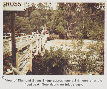 Eltham District Historical Society Inc
Work on paper (Sub-Item) - Photograph, Flooding, View of Diamond Street Bridge, Eltham 8 April 1977
Colour photograph. Flooding of Diamond Creek at Diamond Street Eltham bridge approximately 2 1/2 hours after the flood peak. Note debris on the bridge deck. 8 April 1977. flood, diamond creek, flooding, eltham, diamond street, bridge -
 Eltham District Historical Society Inc
Photograph - Digital Photograph, Alan King, Monash Bridge, Hurstbridge, 23 January 2008
Monash Bridge spans the Diamond Creek at Hurstbridge. It was built in 1917 for the Shires of Heidelberg, Eltham and Whittlesea. It is considered Nillumbik Shire's finest engineered bridge and was construced by the engineering company of Sir John Monash. Covered under Heritage Overlay, Nillumbik Planning Scheme. Published: Nillumbik Now and Then / Marguerite Marshall 2008; photographs Alan King with Marguerite Marshall.; p117 Monash Bridge is considered the Shire’s finest engineered bridge and was constructed by the engineering company of that great Australian, Sir John Monash.1 The bridge spans Diamond Creek on the Hurstbridge-Arthurs Creek Road, linking Hurstbridge with Yarrambat and Arthurs Creek. Monash Bridge, also called Hurst’s Bridge, was built in 1917, by the Reinforced Concrete and Monier Pipe Construction Company Pty Ltd, for the Shires of Heidelberg, Eltham and Whittlesea. Although Monash was probably in action overseas during World War One when the bridge was designed and constructed, he evolved the basic design in the 1900s and it was a standard design for the firm. However J A Laing, a designer at the firm, was probably the designer, as his initials are on bridge drawings held by the Eltham District Historical Society.2 The bridge is an excellent early Australian example of an open spandrel reinforced concrete arch bridge and has a single span of 29 metres. It is unusual in Victoria, but similar to many reinforced concrete arch bridges in Europe and America, built from the late 19th century. In Victoria, Monash pioneered the use of reinforced concrete – then a revolutionary construction material. His company, Monash & Anderson, had the exclusive licence for the Monier patent for the system of reinforced concrete construction for Victoria and New South Wales. A well-known example of the Monier arch bridge is the Morell Bridge in South Yarra. The sweeping arch of the Monash Bridge combines grace and utility and blends with the surrounding rural landscape. Its design and construction have allowed it to carry increasing volumes of heavy traffic, but in modern times the one lane is considered by some to prevent easy passage through Hurstbridge. However others consider this an asset to deter too much more traffic, which would diminish Hurstbridge’s charming rural character.3 This is the third bridge across the Diamond Creek at this site. The original bridge was a log bridge upstream, constructed in the 1850s by early settler, Henry Hurst, after whom Hurstbridge was named. The bridge spanned the creek, where it divided his family’s property. In the 1880s a timber bridge replaced it, known as Hurst’s Bridge. However a more permanent bridge was considered necessary when the new railway arrived in 1912, bringing with it expectations of growth in the town and the surrounding fruit-growing district. Monash Bridge’s official opening on November 3, 1917 was a gala occasion, which took place before about 1000 spectators. Two who attended the opening had a particularly sound knowledge of the locality. One was Fred Hurst, Henry’s brother, who used to ford the creek at or near the bridge’s site more than 50 years before. The other was John McDonald of Arthurs Creek, who had built the old wooden bridge over the creek about 40 years earlier.4 Although John Monash was a fine engineer, his fame came from his brilliant war career, rather than from his engineering or his many other achievements. Monash was Corps Commander of the Australian Forces. His brilliance was recognised with his awards: Knight Grand Cross of the Order of St. Michael and St. George, and Knight Commander of the Bath. Monash was also decorated by the French, Belgian, and American Governments.5 After the war, Monash worked in many prominent civilian positions, the most notable as head of the Victorian State Electricity Commission. He was a leading and loved public figure, involved in many public and private organisations. He was president of the Australian Zionist Federation and involved in the Boy Scouts. Monash University is named after him. By the 1920s Monash was probably regarded as the greatest living Australian.6 Despite most of his life working as an administrator and leader, rather than a fighting soldier, he became integral to the ANZAC legend. Monash died in 1931.This collection of almost 130 photos about places and people within the Shire of Nillumbik, an urban and rural municipality in Melbourne's north, contributes to an understanding of the history of the Shire. Published in 2008 immediately prior to the Black Saturday bushfires of February 7, 2009, it documents sites that were impacted, and in some cases destroyed by the fires. It includes photographs taken especially for the publication, creating a unique time capsule representing the Shire in the early 21st century. It remains the most recent comprehenesive publication devoted to the Shire's history connecting local residents to the past. nillumbik now and then (marshall-king) collection, hurstbridge, monash bridge -
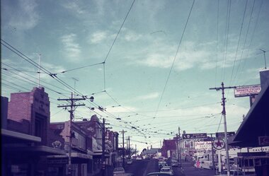 Ballarat Tramway Museum
Slide - 35mm slide/s - set of 4, Dave Simpson, late 1960's early 1970's
Yields information about Stones Corner and the traffic situation in Bridge St.Set of four 35mm slides - Anscochrome white plastic mounts of Stones Corner, corner of Bridge St, Victoria St and Main Road. .1 - shows the overhead arrangements, with a tram about to enter Bridge St from Main Road. Has the Caltex service station in the background, also advert or roof signs for Viscount Ambassador Caravans, K&O (Digger) Schonell Sports Cycles and Electrical store. .2 - No. 26 inbound with many passengers - showing Mt Pleasant - could be running a Special. .3 - ditto with many cars in the photograph. .4 - tram 39 about to enter Bridge St from Main Road - has a red letter box on corner.tramways, trams, main road, bridge st, victoria st, stones corner, tram 26, tram 39 -
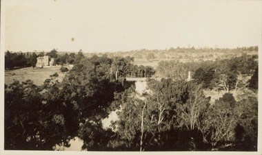 Kew Historical Society Inc
Photograph - Victorian Canoe Club, V.C.C. site, Studley Park, 1920-30
Canoeing on the River Yarra at Melbourne was an important and widespread recreational pursuit for Melbournians, especially in the first half of the twentieth century. The Victorian Canoe Club was formed in 1912 at a meeting in Melbourne and its first committee elected in the same year. Records indicate that the Club continued into at least the 1950s .The album has historic and social significance as a record of recreational activities (as well as canoe making) in the early years of the twentieth century. It has local significance as the site of the headquarters of the Club was in Studley Park. A number of photographs in the album provide vistas of Kew on the Yarra that are otherwise unavailable.One of 24 labelled photos in part album, originating from the Victorian Canoe Club, which had its headquarters in Studley Park, Kew. The album includes a photographic record of canoe construction and also locations in Studley Park and Kew where the canoes were used. The subject of this photograph is identified as 'V.C.C. site, Studley Park'.The panoramic view shows a number of important landmarks during this period. On the left of the photograph is one of the remaining buildings of the Yarra Bend Asylum. Stretching across the river is a suspension bridge on the site of the present Kane's Bridge. The reference to the V.C.C. site is unclear within the context of the photo which appears to be taken from the vicinity of the Johnston Street Bridge."V.C.C. site, Studley Park"victorian canoe club, river yarra, canoe clubs, yarra bend asylum, suspension bridge -- kew, kane's bridge, studley park -
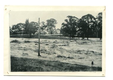 Orbost & District Historical Society
black / white photograph, January 1934
Damage estimated at £500,000 was caused by the 1934 floods in the Orbost district. This 1934 flood was devastating, destroying a section of the 1922 Orbost bridge, wrecking fences, bridges and roads, dumping silt and debris on the rich river flats and drowning cattle. This photograph shows Lochiel Lagoon ( the billabong) in the foreground. Ten minutes after this photograph was taken, the centre span of the Orbost Bridge was washed away.This item is a pictorial record of the 1934 floods, a significant part of Orbost's history.A black / white photograph of swirling floodwaters with township in the background.orbost-floods-1934 natural-disasters-floods -
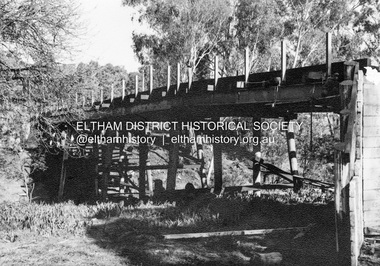
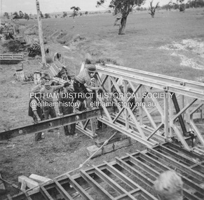
 Eltham District Historical Society Inc
Album - Photograph, J.A. McDonald, Dixons Creek Road, Oct. 1955
October 1955 Erecting Bailey BridgeRecord of various Shire of Eltham infrastructure works undertaken during the period of 1952-1962 involving bridge and road reconstruction projects, sometimes with Eltham Shire Council Project Reference numbers quoted. It was during this period that a number of significant improvements were made to roads and new bridges constructed within the shire that remain in place as of present day (2022). In many situations, the photos provide a tangible visible record of infrastructure that existed throughout the early days of the Shire. The album was put together by or under the direction of the Shire Engineer, J.A. McDonald.infrastructure, road construction, shire of eltham, 1955-10, bailey bridge, bridge construction, dixons creek bridge, dixon's creek road -
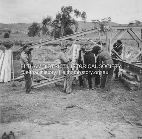
 Eltham District Historical Society Inc
Album - Photograph, J.A. McDonald, Dixons Creek Road, Oct. 1955
October 1955 Construction of Bailey BridgeRecord of various Shire of Eltham infrastructure works undertaken during the period of 1952-1962 involving bridge and road reconstruction projects, sometimes with Eltham Shire Council Project Reference numbers quoted. It was during this period that a number of significant improvements were made to roads and new bridges constructed within the shire that remain in place as of present day (2022). In many situations, the photos provide a tangible visible record of infrastructure that existed throughout the early days of the Shire. The album was put together by or under the direction of the Shire Engineer, J.A. McDonald.infrastructure, road construction, shire of eltham, 1955-10, bailey bridge, bridge construction, dixons creek bridge, dixon's creek road -
 Eltham District Historical Society Inc
Album - Photograph, J.A. McDonald, Healesville-Yarra Glen Road, Aug. 1958
Long Gully Bridge August 1958Record of various Shire of Eltham infrastructure works undertaken during the period of 1952-1962 involving bridge and road reconstruction projects, sometimes with Eltham Shire Council Project Reference numbers quoted. It was during this period that a number of significant improvements were made to roads and new bridges constructed within the shire that remain in place as of present day (2022). In many situations, the photos provide a tangible visible record of infrastructure that existed throughout the early days of the Shire. The album was put together by or under the direction of the Shire Engineer, J.A. McDonald.infrastructure, shire of eltham, 1958-08, bridge construction, long gully bridge, road construction -
 Greensborough Historical Society
Photograph - Digital image, Pope Place bridge Greensborough, 21/05/2014
Pope Place foot bridge, Greensborough.Digital copy of colour photograph.pope place greensborough, foot bridge -
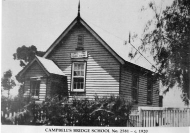 Stawell Historical Society Inc
Photograph, Campbells Bridge Primary School Number 2581 c1920
Campbells Bridge School No 2581 c1920stawell education -
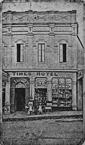 City of Ballarat Libraries
Photograph - Card Box Photographs, Times Hotel, Ballarat 1864
The Time Hotel was located on Bridge Street.time hotel, bridge street, building, hotel