Showing 9242 items matching "x"
-
 Eltham District Historical Society Inc
Photograph, Sherbourne Road, Para Road and Simms Road at Briar Hill/Montmorency prior to the upgrade of Sherbourne Road Railway bridge, c.1970
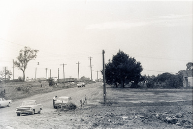
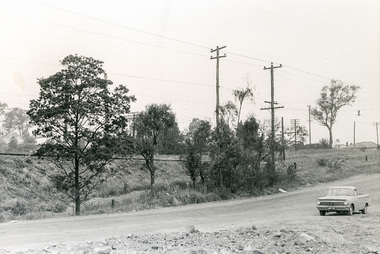
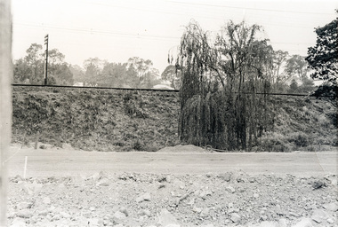
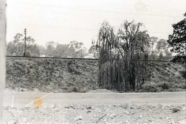
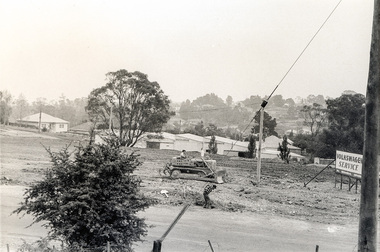
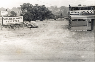
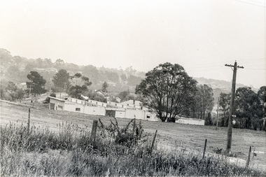
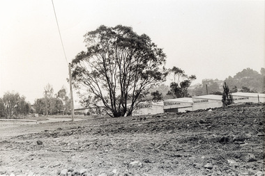
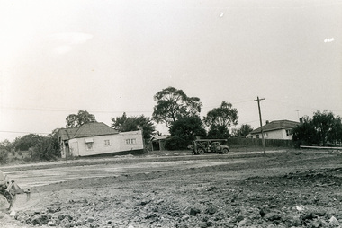
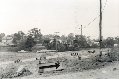
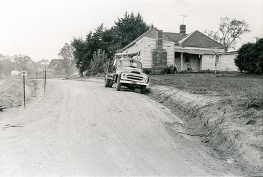
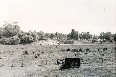
Collection of photographs probably taken around the same time depicting Sherbourne Road, Para Road and Simms Road at Briar Hill/Montmorency prior to the upgrade of Sherbourne Road Railway bridge, c.1970. Photo 01648_ 19 This home owned by Mrs Cameron. Her daughter married a Mr Davey, for whom Davey Road was named - email from M. Jones 20/07/2015 Photographer unknownThese photos are very significant in the documentation of the development of the Briar Hill and Montmorency areas and the changes in the physical landscape along the railway line area.20 black and white prints 9 cm x 13 cm.1970, briar hill, davey road, montmorency, para road, cameron, davey, sherbourne road, simms road, railway line, roadworks -
 Eltham District Historical Society Inc
Photograph, Sherbourne Road, Para Road and Simms Road at Briar Hill/Montmorency prior to the upgrade of Sherbourne Road Railway bridge, c.1970
Collection of photographs probably taken around the same time depicting Sherbourne Road, Para Road and Simms Road at Briar Hill/Montmorency prior to the upgrade of Sherbourne Road Railway bridge, c.1970. Photo 01648_ 19 This home owned by Mrs Cameron. Her daughter married a Mr Davey, for whom Davey Road was named - email from M. Jones 20/07/2015 Photographer unknownThese photos are very significant in the documentation of the development of the Briar Hill and Montmorency areas and the changes in the physical landscape along the railway line area.20 black and white prints 9 cm x 13 cm.1970, briar hill, davey road, montmorency, para road, cameron, davey, sherbourne road, simms road, railway line, roadworks -
 Eltham District Historical Society Inc
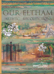
Book, Eltham Cemetery Trust, Our Eltham: Artistic Recollections, Eltham Cemetery Trust 2017, Eltham, Sep 2017
Pictorial guide to the artwork Our Eltham, a collection of 31 panels celebrating life in the Shire that were collaboratively created by artist Nerina Lascelles and ceramicist, Linda Detoma and commissioned by the Eltham Cemetery Trust. Our Eltham Artistic Recollections is a collection of panels that was commissioned by the Eltham Cemetery Trust as part of its vision to offer the community a fresh and unique relationship to the Cemetery. 31 panels were produced depicting historical images of Eltham and the nearby area with images of indigenous flowers and plants. A majority of the images were provided to the collaborating artists in digital form by Yarra Plenty Regional Library in partnership with Eltham District Historical Society who holds the significant Shire of Eltham Pioneers Photograph collection in partnership. EDHS and YPRL staff (Local and Family History Librarian) provided advice on which images to use and also provided assistance with the provision of information and editing services for this booklet, which is also available electronically. The collection of panels was collaboratively created by artist Nerica Lascelles and ceramicist Linda Detoma. The project was designed and constructed by Leigh Wykes with Australian stone and Ironwork by Neil Carter. The panels were unveiled on September 21, 2017Artworks were based on images supplied by Eltham District Historical Society in partnership with Yarra Plenty RegionalLibrarySoftcover booklet; approx 66 pages, 20 x 15 cmnerina lascelles, linda detoma, eltham cemetery, artists, art works -
 Eltham District Historical Society Inc
Book, Heidelberg Golf Club : 50th year, 1928-1978, 1978c
Paperback; [12] p. : ill., ports. ; 21 x 30 cm.heidelberg golf club -
 Eltham District Historical Society Inc
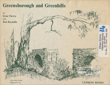
Book, Irene Turvey et al, Greensborough and Greenhills / words by Irene Turvey ; Drawings by Ron Reynolds, 1973
Pen and ink sketches accompanied by appropriate text in double page spreads. Contents cover : Blue stone bridge, Introduction, House cnr Church and Hailes Street, House - 25 Hailes Street, Yandell Reserve, Greensborough Hotel, Lobb's Kiosk, House - 49 Grimshaw Street, View of Greensborough (from Delphin Crescent), Railway Station, Old Barn (near Greensborough Railway Station), Partington's Flat and River Valley, Rand Street Bridge, Lower Main Street, Greenbriar Nursery, Hitching rail, Ashmead - Dr Cordner's Home, Greensborough Primary School, House - cnr St Helena and Diamond Creek Raods, Sondermeyer's Hill, Methodist Church, Football Pavilion, Cemetery, St Katherine's Church, St. Helena, Civic Centre, Briar Hill Timber Mill, 24 River Street, Kelly's Garden Supplies, 158 Main Street, Old Swimming pool, 105 Main Street.Hardback; 62 p. : ill., map ; 19 x 25 cm.ISBN 0909807108 Signed by author and illustrator Two copiesgreenhills, greensborough -
 Eltham District Historical Society Inc
Book, Souvenir Programme: The Opening of Eltham Lodge at Melbourne Citymission's Judge Book Village; Sunday 25 November 2001, 2001
Paperback 21 x 15 cm 16 pages plus coverjudge book village, melbourne citymission, eltham lodge -
 Eltham District Historical Society Inc
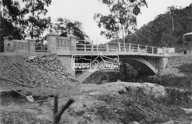
Negative - Photograph, New bridge at Hurstbridge, 1917
The newly constructed re-inforced concrete arched bridge across the Diamond Creek at Hurstbridge designed by John Monash. Eltham Shire shared the cost of the construction of the bridge with Heidelberg and Whittlesea Shires. The bridge was officially opened on 3rd November 1917. Part of a slide show presentation "Bridges & Waterways of the Shire" by Russell Yeoman to the 13 September 1989 Society meeting. The presentation included slides of historic photos from the Shire of Eltham Pioneers collections as well as several recent views.This photo forms part of a collection of photographs gathered by the Shire of Eltham for their centenary project book, "Pioneers and Painters: 100 years of the Shire of Eltham" by Alan Marshall (1971). The collection of over 500 images is held in partnership between Eltham District Historical Society and Yarra Plenty Regional Library (Eltham Library) and is now formally known as 'The Shire of Eltham Pioneers Photograph Collection.' It is significant in being the first community sourced collection representing the places and people of the Shire's first one hundred years.Digital image 4 x 5 inch B&W Negshire of eltham pioneers photograph collection, hurstbridge, bridge, 1917, diamond creek (creek), monash bridge -
 Eltham District Historical Society Inc
Negative - Photograph, The Bridge, Hurstbridge, Vic, c.1925
Copied from brochure "Wattle Valley Estate" 7 minutes from the bridge. The new bridge designed by Sir John Monash over the Diamond Creek near Hurst's home of 'Mia Mia' at Hurstbridge. The Wattle Valley Estate was first advertised in August 1925 as weekend building allotments by the Greater Melbourne Land and Development Company. Advertised from £28.10.0 or £60 per block. In August 1926, 30 picked allotments of 60x150 feet were put up for auction Saturday August 14, 1926 with frontages to Valley View Road and Fawkner Crescent advertised in the “Heart of the Glorious Wattle Country” and “Within 15 Minutes of the Newly Electrified Railway Station”. The Advertiser on August 13, 1926 in an article promoting the auction stated “the estate is regarded as one of the best in the district, and will be sold practically without reserve.” It is noted that an advertisement running in The Argus February 22, 1951 offered the remaining 16 blocks for sale at £12.10.0 or £200 the lot. By March 7, the remaining blocks were advertised at £17.10.0 The Wattle Valley Estate took over 20 years to sell and then people could not build on them This image was also used in a brochure advertising the "Wattle Valley Estate", which forms part of the Shire of Eltham Pioneers Photograph Collection (Cross Reference Photo No.(s): 1056, 1057)This photo forms part of a collection of photographs gathered by the Shire of Eltham for their centenary project book,"Pioneers and Painters: 100 years of the Shire of Eltham" by Alan Marshall (1971). The collection of over 500 images is held in partnership between Eltham District Historical Society and Yarra Plenty Regional Library (Eltham Library) and is now formally known as the 'The Shire of Eltham Pioneers Photograph Collection.' It is significant in being the first community sourced collection representing the places and people of the Shire's first one hundred years.Digital image 4 x 5 inch B&W Negshire of eltham pioneers photograph collection, hurstbridge, bridge, diamond creek (creek), monash bridge, wattle valley estate -
 Eltham District Historical Society Inc
Negative - Photograph, Rose Stereograph Company, The Bridge, Hurstbridge, Vic, c.1925
Copied from brochure "Wattle Valley Estate". The new bridge designed by Sir John Monash over the Diamond Creek near Hurst's original home "Mia Mia" seen in the distance. Reprinted from brochure advertising "Wattle Valley Estate" 7 minutes from bridge. The Wattle Valley Estate was first advertised in August 1925 as weekend building allotments by the Greater Melbourne Land and Development Company. Advertised from £28.10.0 or £60 per block. In August 1926, 30 picked allotments of 60x150 feet were put up for auction Saturday August 14, 1926 with frontages to Valley View Road and Fawkner Crescent advertised in the “Heart of the Glorious Wattle Country” and “Within 15 Minutes of the Newly Electrified Railway Station”. The Advertiser on August 13, 1926 in an article promoting the auction stated “the estate is regarded as one of the best in the district, and will be sold practically without reserve.” It is noted that an advertisement running in The Argus February 22, 1951 offered the remaining 16 blocks for sale at £12.10.0 or £200 the lot. By March 7, the remaining blocks were advertised at £17.10.0 The Wattle Valley Estate took over 20 years to sell and then people could not build on them This image was also used in a brochure advertising the "Wattle Valley Estate", which forms part of the Shire of Eltham Pioneers Photograph Collection (Cross Reference Photo No.(s): 1056, 1057). Also cross reference SEPP_1028 / 29 for other views of Mia Mia. Part of a slide show presentation "Bridges & Waterways of the Shire" by Russell Yeoman to the 13 September 1989 Society meeting. The presentation included slides of historic photos from the Shire of Eltham Pioneers collections as well as several recent views. This photo forms part of a collection of photographs gathered by the Shire of Eltham for their centenary project book,"Pioneers and Painters: 100 years of the Shire of Eltham" by Alan Marshall (1971). The collection of over 500 images is held in partnership between Eltham District Historical Society and Yarra Plenty Regional Library (Eltham Library) and is now formally known as the 'The Shire of Eltham Pioneers Photograph Collection.' It is significant in being the first community sourced collection representing the places and people of the Shire's first one hundred years.Digital image 4 x 5 inch B&W Negshire of eltham pioneers photograph collection, hurstbridge, mia mia, bridge, diamond creek (creek), monash bridge, wattle valley estate -
 Eltham District Historical Society Inc
Negative - Photograph, Popular Picnicing at Hurstbridge, c.1925
Picnickers enjoying a Sunday outing near the Wattle Valley Estate at Hurstbridge. Copied from brochure "Wattle Valley Estate". It is believed the picture is taken at the northwest corner of the intersection of Wattletree Road and Hurstbridge-Arthurs Creek Road looking southeast towards the township (most likely where the house is located on the property of what is today No. 2 Wattletree Road)- https://goo.gl/maps/VDorwCe1rJJUapjE6 According to a comment by Jean Verso (via @nillumbikcouncil FB page 3 Jan 2020) - "This view is from Wattle Tree Road with Haleys Gully Road to the right and across the creek to William Gray's nursery at Allwood. The building to the far left looks like Dorset House. The building on the left in the middle distance is still there today and has been used for storage and as a stable/tack room for a number of years." The Wattle Valley Estate was first advertised in August 1925 as weekend building allotments by the Greater Melbourne Land and Development Company. Advertised from £28.10.0 or £60 per block. In August 1926, 30 picked allotments of 60x150 feet were put up for auction Saturday August 14, 1926 with frontages to Valley View Road and Fawkner Crescent advertised in the “Heart of the Glorious Wattle Country” and “Within 15 Minutes of the Newly Electrified Railway Station”. The Advertiser on August 13, 1926 in an article promoting the auction stated “the estate is regarded as one of the best in the district, and will be sold practically without reserve.” It is noted that an advertisement running in The Argus February 22, 1951 offered the remaining 16 blocks for sale at £12.10.0 or £200 the lot. By March 7, the remaining blocks were advertised at £17.10.0 The Wattle Valley Estate took over 20 years to sell and then people could not build on them Cross Ref EDHS_02665 Rose Series Postcard P. 4341, "View at Hurstbridge, Vic." Also, other images from sales brochure SEPP_1055 / 1056This photo forms part of a collection of photographs gathered by the Shire of Eltham for their centenary project book,"Pioneers and Painters: 100 years of the Shire of Eltham" by Alan Marshall (1971). The collection of over 500 images is held in partnership between Eltham District Historical Society and Yarra Plenty Regional Library (Eltham Library) and is now formally known as the 'The Shire of Eltham Pioneers Photograph Collection.' It is significant in being the first community sourced collection representing the places and people of the Shire's first one hundred years.Digital image 4 x 5 inch B&W Neg1925, dorset house, fawkner crescent, haleys gully road, hurstbridge, hurstbridge-arthurs creek road, picnic, postcards, shire of eltham pioneers photograph collection, valley view road, wattle valley estate, wattletree road, exhibition yprl 2019-12 -
 Eltham District Historical Society Inc
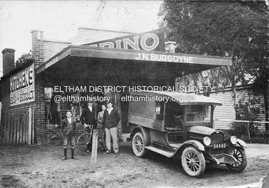
Negative - Photograph, J.N. Burgoyne’s store, Main Road, Eltham, Vic, c.1930
The photo is of John Neville and Ethel (Polly) Burgoyne’s store with eldest children and a 1927/28 model Chevrolet 1 ton truck. The store was located on Main Road just south of Bridge Street (present day No. 820 Main Road). L-R (unconfirmed): Francis (Frank) Neville Burgoyne (1916-2002), unidentified, Mary Frances Burgoyne (1914-1991) and John (Jack) William Burgoyne (1913-2005) which would date the picture as circa 1929/1930. Henry Charles Burgoyne (1920-1994) and Royston (Roy) Edward Burgoyne (1922-2004) not in picture. The unidentified male is believed to be an early boyfriend of Mary Frances at the time, not Reginald John Squire (1916-1981) whom she married in 1938 who was two years her junior. The new store was built in late 1925. At the same time Mr C. Nicholls’s new store was constructed. Both were considered modern shops, and an improvement on most, business establishments of the time. Mr. Nicholls’s store included alongside it a modern, weatherboard villa residence. Mr. Burgoyne’s store incorporated the post and telegraph office, which was operated by John Neville Burgoyne’s half-aunt, Miss Anne Hunniford. The unsealed footpath in front is reasonably extensive as not visible is a concrete kerb and channel which was laid from the Post Office to John Street during Nov-Dec 1926. Footpath construction in front of Burgoyne’s store commenced August 1942. An extension to the store was erected in 1939 for a new telephone exchange adjacent to the store and post office. A continuous telephone service operated by Mr Burgoyne and his family commenced operation 18 November 1939. Approximately 70 extensions were routed through the new exchange, 40 of which were transferred from the Greensborough Exchange. Reproduced on p92 of 'Pioneers & Painters' Cross Ref: 0702 shows extension on right of shopThis photo forms part of a collection of photographs gathered by the Shire of Eltham for their centenary project book,"Pioneers and Painters: 100 years of the Shire of Eltham" by Alan Marshall (1971). The collection of over 500 images is held in partnership between Eltham District Historical Society and Yarra Plenty Regional Library (Eltham Library) and is now formally known as the 'The Shire of Eltham Pioneers Photograph Collection.' It is significant in being the first community sourced collection representing the places and people of the Shire's first one hundred years.Digital image 4 x 5 inch B&W Negshire of eltham pioneers photograph collection, 1927 chevrolet series aa truck, burgoyne's shop, eltham, francis (frank) neville burgoyne (1916-2002), frank burgoyne, henry charles burgoyne (1920-1994), jack burgoyne, john (jack) william burgoyne (1913-2005), john neville burgoyne, main road, mary frances burgoyne squire (1914-1991), pioneers and painters, post office, shops -
 Eltham District Historical Society Inc
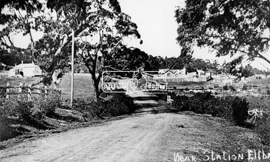
Negative - Photograph, Near station, Eltham, c.1910
Eltham - Main Road. Looking south near Railway Station. Diamond Street on right. This photo forms part of a collection of photographs gathered by the Shire of Eltham for their centenary project book,"Pioneers and Painters: 100 years of the Shire of Eltham" by Alan Marshall (1971). The collection of over 500 images is held in partnership between Eltham District Historical Society and Yarra Plenty Regional Library (Eltham Library) and is now formally known as the 'The Shire of Eltham Pioneers Photograph Collection.' It is significant in being the first community sourced collection representing the places and people of the Shire's first one hundred years.Digital image 4 x 5 inch B&W Negsepp, shire of eltham pioneers photograph collection, eltham, main road, railway station, eltham railway station -
 Eltham District Historical Society Inc
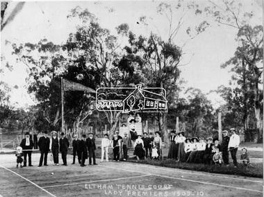
Negative - Photograph, Eltham Tennis Court. Lady Premiers 1909-1910, 1910
A large group of men and women pose for a photograph on Eltham tennis court. Although the photo is marked ”Lady Premiers”, this is not a typical formal sports group pose, with only two women identified as holding racquets. 33 individuals, including men and children and one dog pose for the camera, the majority of whom are not dressed to play tennis. The court shows clear markings for tennis and a flag is flying in the background. The photograph is taken from inside the wire enclosure. There are mature gum trees in the background. The tennis court was situated in Eltham South at Bremner’s Flats (near present day Wingrove Park). Cross Ref SEPP_0720 which is at an earlier level of development. The Eltham Lawn Tennis Club was formed on a Saturday evening, the 29th of October, 1898 at a meeting held at the Eltham State school. The meeting was large and representative. Twenty members were enrolled, and eight more have since been added. Officers and a committee were duly elected, and the Treasurer was instructed to purchase the necessary requisites without delay. By the end of the first week in November all the requisites were to hand, two courts were marked out, and practice begun. The formal opening of the Courts of this Club took place on Saturday, November 12, 1898, when 26 members and their friends assembled. After several sets had been contested an adjournment was made for tea provided by the members and nicely laid out under the shade of the trees. Afterwards, sets were again formed and the game was proceeded with in a lively spirit till nearly dark, when all dispersed having thoroughly enjoyed themselves during the afternoon. (Evelyn Observer, and South and East Bourke Record (Vic. : 1882 - 1902), Friday 18 November 1898, page 2)This photo forms part of a collection of photographs gathered by the Shire of Eltham for their centenary project book,"Pioneers and Painters: 100 years of the Shire of Eltham" by Alan Marshall (1971). The collection of over 500 images is held in partnership between Eltham District Historical Society and Yarra Plenty Regional Library (Eltham Library) and is now formally known as 'The Shire of Eltham Pioneers Photograph Collection.' It is significant in being the first community sourced collection representing the places and people of the Shire's first one hundred years.Digital image 4 x 5 inch B&W Negshire of eltham pioneers photograph collection, 1910, bremner's flat, eltham, eltham lawn tennis club, eltham tennis court, tennis court, wingrove park, laura williams, williams -
 Eltham District Historical Society Inc
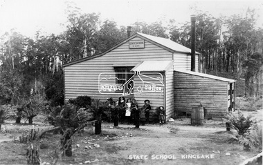
Negative - Photograph, Kinglake State School No. 2188, c.1915
Burnt down 1927. Reproduced on p75 of 'Pioneers & Painters'.This photo forms part of a collection of photographs gathered by the Shire of Eltham for their centenary project book,"Pioneers and Painters: 100 years of the Shire of Eltham" by Alan Marshall (1971). The collection of over 500 images is held in partnership between Eltham District Historical Society and Yarra Plenty Regional Library (Eltham Library) and is now formally known as the 'The Shire of Eltham Pioneers Photograph Collection.' It is significant in being the first community sourced collection representing the places and people of the Shire's first one hundred years.Digital image 4 x 5 inch B&W Negsepp, shire of eltham pioneers photograph collection, kinglake, kinglake state school no. 2188, pioneers and painters, school -
 Eltham District Historical Society Inc
Negative - Photograph, Eltham War Memorial Obelisk 1914-1918, cnr. Main Road and Bridge Street, c.1925
Located on what was referred to as Obelisk Corner, improvements have been been made since the unveiling in August 1919 with the provision of a stone retaining wall topped with a chain link and granite stone boundary, most likely in conjunction with improvements to the intersection into Main Road. Along with the use of the name Obelisk Corner, the Bridge Street bridge was also known as Obelisk Bridge. The Eltham Obelisk was originally located at the corner of Bridge and Main Roads in 1919. In 1943 (WW2) the local community commenced plans to establish the Eltham War Memorial, a living memorial to benefit the children as opposed to a one in stone as per the obelisk. The Eltham War Memorial Trust was established in 1945. In 1947 the Trust intended for the Obelisk to be relocated from Bridge Street and Main Road to the Garden of Remembrance which was planned as part of the Baby Health Centre which was to be the first of three buildings of the Eltham War Memorial to be built in 1951. In 1951 the Eltham RSL was invited to be represented on the Eltham War Memorial Trust. Around this time, with pending roadworks, the obelisk was relocated to the front garden of the Eltham RSL sub branch on Main Road for safe keeping. In 2007, a suggestion was proposed by Harry Gilham (President, EDHS) to John Cohen (ERSL) to claim a special site along with the historic Shillinglaw trees on the now vacant former Eltham Shire Office site adjacent to the Eltham War Memorial precinct for relocation of the obelisk. In 2010 following the financial collapse and sale of the Eltham RSL Sub-Branch property and amalgamation with the Montmorency Eltham RSL sub-branch, the location of the obelisk was again in immediate jepoardy and in conjunction with Nillumbik Shire Council, the obelisk was relocated in front of the Eltham War Memorial buildings in preparation for the Dawn Service on Anzac Day 2012.This photo forms part of a collection of photographs gathered by the Shire of Eltham for their centenary project book,"Pioneers and Painters: 100 years of the Shire of Eltham" by Alan Marshall (1971). The collection of over 500 images is held in partnership between Eltham District Historical Society and Yarra Plenty Regional Library (Eltham Library) and is now formally known as the 'The Shire of Eltham Pioneers Photograph Collection.' It is significant in being the first community sourced collection representing the places and people of the Shire's first one hundred years.Digital image 4 x 5 inch B&W Negsepp, shire of eltham pioneers photograph collection, eltham, main road, eltham war memorial, bridge street, obelisk, obelisk corner -
 Eltham District Historical Society Inc
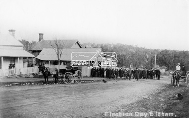
Negative - Photograph, Tom Prior, Election Day, Eltham, 4 June 1907
Election Day, Legislative Council Elections, Tuesday, 4 June 1907, Maria Street (Main Road), Eltham. Group of men standing outside George Knapman’s forge on Election Day (4 June 1907) for the Legislative Council. Voting was conducted in the Eltham Courthouse next door, visible behind the forge. At that time women did not have the right to vote; two women wait on the horse and buggy and two others are looking on from the verandah of the house next door. A dog also sits patiently on the road. The Police Station and residence are just visible on the corner of Brougham Street. Reproduced on p62 of 'Pioneers & Painters' Cross Ref: 0629This photo forms part of a collection of photographs gathered by the Shire of Eltham for their centenary project book,"Pioneers and Painters: 100 years of the Shire of Eltham" by Alan Marshall (1971). The collection of over 500 images is held in partnership between Eltham District Historical Society and Yarra Plenty Regional Library (Eltham Library) and is now formally known as the 'The Shire of Eltham Pioneers Photograph Collection.' It is significant in being the first community sourced collection representing the places and people of the Shire's first one hundred years. The Reynolds family were early settlers in Research. The Reynolds/ Prior collection of photographs were taken by Tom Prior, the maternal uncle of Ivy Reynolds, around 1900 and the 60 photos in the album give a fine overview of many of the landmarks of Research and Eltham over 100 years ago. lvy lived in the family home for many years at 106 Thompson Cres Research. Ivy's father, Ernst Richard Reynolds and grandfather, Richard Reynolds, lived at the same address. Ivy's father Richard worked for Mr. Trail on his property in Research. Reynolds Road is named after the family. Mr Tom Prior (wife Eva) worked at the Melbourne zoo. He was very innovative and made his own camera, using the black cloth hood to exclude the light. The photographs are a reminder of the rural nature of Research and Eltham and its rich heritage.Digital image 4 x 5 inch B&W Negshire of eltham pioneers photograph collection, eltham, main road, knapman's forge, election day, elections, eltham courthouse, forge, george knapman, knapmans forge, maria street, pioneers and painters, reynolds prior collection, court house, courthouse, g. knapman, sepp -
 Eltham District Historical Society Inc
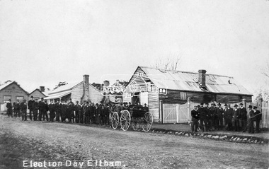
Negative - Photograph, Tom Prior, Election Day, Eltham, 4 June 1907
Election Day, Legislative Council Elections, Tuesday, 4 June 1907, Maria Street (Main Road), Eltham. Group of men standing outside George Knapman’s forge on Election Day (4 June 1907) for the Legislative Council. Voting was conducted in the Eltham Courthouse next door, to the right of photo. At that time women did not have the right to vote. At the far left can be see William B. Andrew’s Corn Store on the corner of Franklin Street. The weatherboard house in between at one stage the home of Miss George.This photo forms part of a collection of photographs gathered by the Shire of Eltham for their centenary project book,"Pioneers and Painters: 100 years of the Shire of Eltham" by Alan Marshall (1971). The collection of over 500 images is held in partnership between Eltham District Historical Society and Yarra Plenty Regional Library (Eltham Library) and is now formally known as the 'The Shire of Eltham Pioneers Photograph Collection.' It is significant in being the first community sourced collection representing the places and people of the Shire's first one hundred years. The Reynolds family were early settlers in Research. The Reynolds/ Prior collection of photographs were taken by Tom Prior, the maternal uncle of Ivy Reynolds, around 1900 and the 60 photos in the album give a fine overview of many of the landmarks of Research and Eltham over 100 years ago. lvy lived in the family home for many years at 106 Thompson Cres Research. Ivy's father, Ernst Richard Reynolds and grandfather, Richard Reynolds, lived at the same address. Ivy's father Richard worked for Mr. Trail on his property in Research. Reynolds Road is named after the family. Mr Tom Prior (wife Eva) worked at the Melbourne zoo. He was very innovative and made his own camera, using the black cloth hood to exclude the light. The photographs are a reminder of the rural nature of Research and Eltham and its rich heritage.Digital image 4 x 5 inch B&W Negelection day, elections, eltham, eltham courthouse, forge, george knapman, knapmans forge, main road, maria street, miss george, reynolds prior collection, shire of eltham pioneers photograph collection, w.b. andrew corn store -
 Eltham District Historical Society Inc
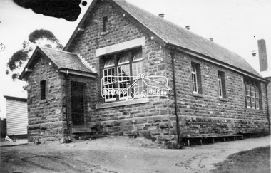
Photograph, Eltham State School No. 209, Dalton Street, Eltham, c.1918
Eltham Primary School. This building is the earliest building remaining on site today. It was built in 1875 and was the second school building replacing the original 1856 building of stone walls with wooden shingles on the roof. That building needed to be replaced after the stone walls collapsed outwards. In August 1912 the school issued a requisition for remodelling of the school concerned with replacement of the existing windows with larger and wider windows to allow additional light into the school rooms and the erection of a wooden partition in the centre of the room. This work commenced in early 1914 and this photo shows the altered windows. Pre 1921 extension and skylights in roof. Only two low wooden stairs present to enter the porch. These were rebuilt by 1928. A steel mud grate was introduced 1930s/1940s and an infant shelter shed is shown on the 1945 plan. Photo most likely taken between 1914 and 1921.This photo forms part of a collection of photographs gathered by the Shire of Eltham for their centenary project book,"Pioneers and Painters: 100 years of the Shire of Eltham" by Alan Marshall (1971). The collection of over 500 images is held in partnership between Eltham District Historical Society and Yarra Plenty Regional Library (Eltham Library) and is now formally known as the 'The Shire of Eltham Pioneers Photograph Collection.' It is significant in being the first community sourced collection representing the places and people of the Shire's first one hundred years.Digital image 4 x 5 inch B&W Negsepp, shire of eltham pioneers photograph collection, eltham, dalton street, state school no. 209, eltham primary school, eltham state school, schools -
 Eltham District Historical Society Inc
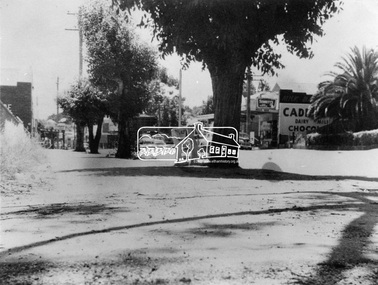
Negative - Photograph, Eltham - Main Road, 1950s
Source: Geo. W. Bell, Eltham This photo forms part of a collection of photographs gathered by the Shire of Eltham for their centenary project book,"Pioneers and Painters: 100 years of the Shire of Eltham" by Alan Marshall (1971). The collection of over 500 images is held in partnership between Eltham District Historical Society and Yarra Plenty Regional Library (Eltham Library) and is now formally known as the 'The Shire of Eltham Pioneers Photograph Collection.' It is significant in being the first community sourced collection representing the places and people of the Shire's first one hundred years.Digital image 4 x 5 inch B&W Negsepp, shire of eltham pioneers photograph collection, eltham, george w bell, main road -
 Eltham District Historical Society Inc
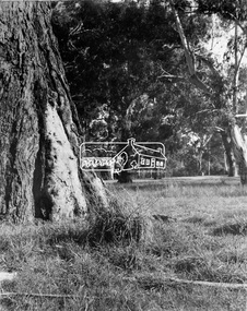
Negative - Photograph, Eltham - Wingrove Park, early 1950s
Scar tree in foreground of Wingrove Park, named for Charles Symons Wingrove who was Secretary and Engineer for the Shire of Eltham for almost 50 years This photo forms part of a collection of photographs gathered by the Shire of Eltham for their centenary project book,"Pioneers and Painters: 100 years of the Shire of Eltham" by Alan Marshall (1971). The collection of over 500 images is held in partnership between Eltham District Historical Society and Yarra Plenty Regional Library (Eltham Library) and is now formally known as the 'The Shire of Eltham Pioneers Photograph Collection.' It is significant in being the first community sourced collection representing the places and people of the Shire's first one hundred years.Digital image 4 x 5 inch B&W Negsepp, shire of eltham pioneers photograph collection, eltham, george w bell, main road, wingrove park, tree, scar tree