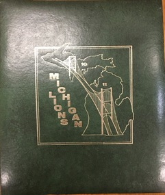
Showing 2670 items
matching 1980s
-
 Kew Historical Society Inc
Plan - Subdivision Plan, Violet Farm Estate, 1927
Pru Sanderson, in her groundbreaking ‘City of Kew Urban Conservation Study : Volume 2 - Development History’ (1988), summarised the periods of urban development and subdivisions of land in Kew. The periods that she identified included 1845-1880, 1880-1893, 1893-1921, 1921-1933, 1933-1943, and Post-War Development. These periods were selected as they represented periods of rapid growth or decline in urban development. An obvious starting point for Sanderson’s groupings involved population growth and the associated economic cycles. These cycles also highlighted urban expansion onto land that was predominantly rural, although in other cases it represented the decline and breakup of large estates. A number of the plans in the Kew Historical Society’s collection can also be found in other collections, such as those of the State Library of Victoria and the Boroondara Library Service. A number are however unique to the collection.The Kew Historical Society collection includes almost 100 subdivision plans pertaining to suburbs of the City of Melbourne. Most of these are of Kew, Kew East or Studley Park, although a smaller number are plans of Camberwell, Deepdene, Balwyn and Hawthorn. It is believed that the majority of the plans were gifted to the Society by persons connected with the real estate firm - J. R. Mathers and McMillan, 136 Cotham Road, Kew. The Plans in the collection are rarely in pristine form, being working plans on which the agent would write notes and record lots sold and the prices of these.The subdivision plans are historically significant examples of the growth of urban Melbourne from the beginning of the 20th Century up until the 1980s. A number of the plans are double-sided and often include a photograph on the reverse. A subdivision plan for nineteen ‘bonny, airy building blocks’ on either side of Violet Grove, Kew East. Violet Grove runs between High Street and Harp Road. Like many other subdivisions in Kew and East Kew, older houses (Lots 1 and 13) were often included in the subdivision. Such houses were in some instances the original properties that were subdivided, or in the case of the Violet Grove subdivision, new houses such as the weatherboard villa on lot 13. This villa is advertised as having a tiled roof, 5 rooms, panelled hall, double doors (Rooms 14 x 12 ft. 6 in. (2) 14 x 12, 12 x 11, 13 x 11). A bricked front verandah, a tiled stove recess and existing sewerage connection added to its saleable potential. Water, electric light and power, and gas were all offered as part of the deal. Violet Grove now has about 35 houses, which indicates that the 19 lots of the subdivision were to be further subdivided by purchasers. [A similar plan is in the Batten & Percy Collection of the State Library of Victoria.]subdivision plans - east kew, violet farm estate, violet grove -- kew (vic.), boorool road -- kew (vic.), harp road -- kew east (vic.) -
 Kew Historical Society Inc
Plan - Subdivision Plan, Flower Farm Estate, East Kew, 1922
Pru Sanderson, in her groundbreaking ‘City of Kew Urban Conservation Study : Volume 2 - Development History’ (1988), summarised the periods of urban development and subdivisions of land in Kew. The periods that she identified included 1845-1880, 1880-1893, 1893-1921, 1921-1933, 1933-1943, and Post-War Development. These periods were selected as they represented periods of rapid growth or decline in urban development. An obvious starting point for Sanderson’s groupings involved population growth and the associated economic cycles. These cycles also highlighted urban expansion onto land that was predominantly rural, although in other cases it represented the decline and breakup of large estates. A number of the plans in the Kew Historical Society’s collection can also be found in other collections, such as those of the State Library of Victoria and the Boroondara Library Service. A number are however unique to the collection.The Kew Historical Society collection includes almost 100 subdivision plans pertaining to suburbs of the City of Melbourne. Most of these are of Kew, Kew East or Studley Park, although a smaller number are plans of Camberwell, Deepdene, Balwyn and Hawthorn. It is believed that the majority of the plans were gifted to the Society by persons connected with the real estate firm - J. R. Mathers and McMillan, 136 Cotham Road, Kew. The Plans in the collection are rarely in pristine form, being working plans on which the agent would write notes and record lots sold and the prices of these. The subdivision plans are historically significant examples of the growth of urban Melbourne from the beginning of the 20th Century up until the 1980s. A number of the plans are double-sided and often include a photograph on the reverse. The subdivision called the ‘Flower Farm Estate’ in Kew East occurred in 1922. It included 61 lots on either side of Boorool Road between High Street and Harp Road. In an advertisement in The Argus in the same year, the proximity of the estate to the newly erected shops at the corner of Harp Road and High Street is noted. The Flower Farm Estate and similar subdivisions in Kew East were assisted by the extension of the High Street tramline in 1924.subdivision plans - east kew, flower farm estate, high street - kew east (vic.), boorool road -- kew east (vic.), harp road -- kew east (vic.) -
 Kew Historical Society Inc
Plan - Subdivision Plan, Palmyra Estate, 1918
Pru Sanderson, in her groundbreaking ‘City of Kew Urban Conservation Study : Volume 2 - Development History’ (1988), summarised the periods of urban development and subdivisions of land in Kew. The periods that she identified included 1845-1880, 1880-1893, 1893-1921, 1921-1933, 1933-1943, and Post-War Development. These periods were selected as they represented periods of rapid growth or decline in urban development. An obvious starting point for Sanderson’s groupings involved population growth and the associated economic cycles. These cycles also highlighted urban expansion onto land that was predominantly rural, although in other cases it represented the decline and breakup of large estates. A number of the plans in the Kew Historical Society’s collection can also be found in other collections, such as those of the State Library of Victoria and the Boroondara Library Service. A number are however unique to the collection.The Kew Historical Society collection includes almost 100 subdivision plans pertaining to suburbs of the City of Melbourne. Most of these are of Kew, Kew East or Studley Park, although a smaller number are plans of Camberwell, Deepdene, Balwyn and Hawthorn. It is believed that the majority of the plans were gifted to the Society by persons connected with the real estate firm - J. R. Mathers & McMillan, 136 Cotham Road, Kew. The Plans in the collection are rarely in pristine form, being working plans on which the agent would write notes and record lots sold and the prices of these. The subdivision plans are historically significant examples of the growth of urban Melbourne from the beginning of the 20th Century up until the 1980s. A number of the plans are double-sided and often include a photograph on the reverse. In 1918, Punch reported the sale of the Palmyra Estate. ‘Adjoining the Findon Estate at Kew is Palmyra, one of the most charming localities in this most desirable of all suburbs. Palmyra has frontages to Findon, Bakewell, Carson and Stevenson streets. Facing Carson street are eight blocks of 60 by 140; on Stevenson-street four of 60 by 232; and there are four of 60 by 233 on Bakewell-street.’ [Bakewell Street and Findon Street were later to be amalgamated into Findon Crescent.]subdivision plans - kew, studley park, palymyra estate, stevenson street -- kew (vic.), carson street -- kew (vic.), bakewell street (findon crescent) -- kew (vic.) -
 Kew Historical Society Inc
Plan - Subdivision Plan, Kewdene Estate, 1937-1939
Pru Sanderson, in her groundbreaking ‘City of Kew Urban Conservation Study : Volume 2 - Development History’ (1988), summarised the periods of urban development and subdivisions of land in Kew. The periods that she identified included 1845-1880, 1880-1893, 1893-1921, 1921-1933, 1933-1943, and Post-War Development. These periods were selected as they represented periods of rapid growth or decline in urban development. An obvious starting point for Sanderson’s groupings involved population growth and the associated economic cycles. These cycles also highlighted urban expansion onto land that was predominantly rural, although in other cases it represented the decline and breakup of large estates. A number of the plans in the Kew Historical Society’s collection can also be found in other collections, such as those of the State Library of Victoria and the Boroondara Library Service. A number are however unique to the collection.The Kew Historical Society collection includes almost 100 subdivision plans pertaining to suburbs of the City of Melbourne. Most of these are of Kew, Kew East or Studley Park, although a smaller number are plans of Camberwell, Deepdene, Balwyn and Hawthorn. It is believed that the majority of the plans were gifted to the Society by persons connected with the real estate firm - J. R. Mathers & McMillan, 136 Cotham Road, Kew. The Plans in the collection are rarely in pristine form, being working plans on which the agent would write notes and record lots sold and the prices of these. The subdivision plans are historically significant examples of the growth of urban Melbourne from the beginning of the 20th Century up until the 1980s. A number of the plans are double-sided and often include a photograph on the reverse. The advertisement for the ‘Kewdene Estate’ subdivision is pasted over a photograph of a property for sale. This is typical of the reuse of promotional materials in the period during, and subsequent to World War I. The subdivision included 14 lots bordered by Belmore Road, Birtles Street and Giles Street. On the other side of the subdivision [Glass] Creek is noted. The subdivision plan also shows part of the Outer Circle Railway and Deepdene Railway Station.subdivision plans - east kew, kewdene estate, belmore road -- kew east (vic.), giles street -- kew east (vic.) -
 Kew Historical Society Inc
Plan - Subdivision Plan, Boulevard Estate - Boulevard Section, 1930-1936
Pru Sanderson, in her groundbreaking ‘City of Kew Urban Conservation Study : Volume 2 - Development History’ (1988), summarised the periods of urban development and subdivisions of land in Kew. The periods that she identified included 1845-1880, 1880-1893, 1893-1921, 1921-1933, 1933-1943, and Post-War Development. These periods were selected as they represented periods of rapid growth or decline in urban development. An obvious starting point for Sanderson’s groupings involved population growth and the associated economic cycles. These cycles also highlighted urban expansion onto land that was predominantly rural, although in other cases it represented the decline and breakup of large estates. A number of the plans in the Kew Historical Society’s collection can also be found in other collections, such as those of the State Library of Victoria and the Boroondara Library Service. A number are however unique to the collection.The Kew Historical Society collection includes almost 100 subdivision plans pertaining to suburbs of the City of Melbourne. Most of these are of Kew, Kew East or Studley Park, although a smaller number are plans of Camberwell, Deepdene, Balwyn and Hawthorn. It is believed that the majority of the plans were gifted to the Society by persons connected with the real estate firm - J. R. Mathers and McMillan, 136 Cotham Road, Kew. The Plans in the collection are rarely in pristine form, being working plans on which the agent would write notes and record lots sold and the prices of these. The subdivision plans are historically significant examples of the growth of urban Melbourne from the beginning of the 20th Century up until the 1980s. A number of the plans are double-sided and often include a photograph on the reverse. This plan shows a subdivision with two sections: the ‘Boulevard Section’ and the ‘Riverside Section’. The first of these sections bordered Burke Road between Kilby Road and the farm beside the Yarra. Kilby Road, Munro Road, Burke Road and Old Burke Road bordered the 102 lots in the Boulevard Section of the plan. The streets within the Section included Walbundry Avenue, Inverness Way, Riverside Avenue, Cascade Street and Kyora Parade. These street names, at least in this subdivision plan linked the two Sections of the subdivision. At a later date, the City of Kew decided to alter the street names. Walbundry, Inverness, Riverside, Cascade and Kyora were all renamed as ‘Drives’ (e.g. Kyora Drive). The subdivision plan is of interest in that it names High Street in Kew as Doncaster Road. It also shows the location of the wooden church that was later removed to Yarraville on the corner of Kilby Road and High Street. The plan predates later developments such as the S. E. Dickens Supermarket.subdivision plans - east kew, boulevard estate, munro road -- kew east (vic.), kilby road -- kew east (vic.), burke road -- kew east (vic.), walbundry avenue -- kew east (vic.), inverness way -- kew east (vic.), riverside avenue -- kew east (vic.), cascade drive -- kew east (vic.), nyora parade -- kew east (vic.) -
 Kew Historical Society Inc
Plan - Subdivision Plan, Goldthorns Hill Estate, 1925
Pru Sanderson, in her groundbreaking ‘City of Kew Urban Conservation Study : Volume 2 - Development History’ (1988), summarised the periods of urban development and subdivisions of land in Kew. The periods that she identified included 1845-1880, 1880-1893, 1893-1921, 1921-1933, 1933-1943, and Post-War Development. These periods were selected as they represented periods of rapid growth or decline in urban development. An obvious starting point for Sanderson’s groupings involved population growth and the associated economic cycles. These cycles also highlighted urban expansion onto land that was predominantly rural, although in other cases it represented the decline and breakup of large estates. A number of the plans in the Kew Historical Society’s collection can also be found in other collections, such as those of the State Library of Victoria and the Boroondara Library Service. A number are however unique to the collection.The Kew Historical Society collection includes almost 100 subdivision plans pertaining to suburbs of the City of Melbourne. Most of these are of Kew, Kew East or Studley Park, although a smaller number are plans of Camberwell, Deepdene, Balwyn and Hawthorn. It is believed that the majority of the plans were gifted to the Society by persons connected with the real estate firm - J. R. Mathers and McMillan, 136 Cotham Road, Kew. The Plans in the collection are rarely in pristine form, being working plans on which the agent would write notes and record lots sold and the prices of these. The subdivision plans are historically significant examples of the growth of urban Melbourne from the beginning of the 20th Century up until the 1980s. A number of the plans are double-sided and often include a photograph on the reverse. The Goldthorns Hill Estate subdivision was first put up for auction in 1925. The subdivision took its name from the mansion ‘Goldthorns’, shown on the plan between Normanby Road and Lady Loch’s Drive. Contemporary advertisements describe forty-three home sites being fro sale, yet only forty-one appear on this plan. Buyers were lured by the prospect of the proposed extension of the Burke Road tram to High Street. Discerning buyers were advised that only one house could be built per allotment, and that houses needed to be constructed of brick, stone or concrete and have a slate or tiled roof.goldthorns avenue -- kew east (vic.), lady loch drive -- kew east (vic.), argyle road -- kew east (vic.), lady brassey drive -- kew east (vic.), campbell street -- kew east (vic.), goldthorns -- kew (vic.), subdivisions -- kew east (viv.), goldthorns hill estate -
 Kew Historical Society Inc
Plan - Subdivision Plan, Rimington Nursery Estate, 1949
Pru Sanderson, in her groundbreaking ‘City of Kew Urban Conservation Study : Volume 2 - Development History’ (1988), summarised the periods of urban development and subdivisions of land in Kew. The periods that she identified included 1845-1880, 1880-1893, 1893-1921, 1921-1933, 1933-1943, and Post-War Development. These periods were selected as they represented periods of rapid growth or decline in urban development. An obvious starting point for Sanderson’s groupings involved population growth and the associated economic cycles. These cycles also highlighted urban expansion onto land that was predominantly rural, although in other cases it represented the decline and breakup of large estates. A number of the plans in the Kew Historical Society’s collection can also be found in other collections, such as those of the State Library of Victoria and the Boroondara Library Service. A number are however unique to the collection.The Kew Historical Society collection includes almost 100 subdivision plans pertaining to suburbs of the City of Melbourne. Most of these are of Kew, Kew East or Studley Park, although a smaller number are plans of Camberwell, Deepdene, Balwyn and Hawthorn. It is believed that the majority of the plans were gifted to the Society by persons connected with the real estate firm - J. R. Mathers and McMillan, 136 Cotham Road, Kew. The Plans in the collection are rarely in pristine form, being working plans on which the agent would write notes and record lots sold and the prices of these. The subdivision plans are historically significant examples of the growth of urban Melbourne from the beginning of the 20th Century up until the 1980s. A number of the plans are double-sided and often include a photograph on the reverse. A number of the latter are by noted photographers such as J.E. Barnes.The house lots in the Rimington Nursery Estate were advertised for sale on Saturday 22nd October 1949. The nine lots in the sale were in Stoke Avenue and Burke Road. Mathers & McMillan of 136 Cotham Road, Kew, offered the lots for sale. [The final sale of lots within the Rimington Nursery Estate occurred as late as 1958.]subdivision plans - kew, rimington nursery estate, monist victor road - kew (vic.) -
 Kew Historical Society Inc
Plan - Subdivision Plan, Erin Heights Estate, East kew, 1917
Pru Sanderson, in her groundbreaking ‘City of Kew Urban Conservation Study : Volume 2 - Development History’ (1988), summarised the periods of urban development and subdivisions of land in Kew. The periods that she identified included 1845-1880, 1880-1893, 1893-1921, 1921-1933, 1933-1943, and Post-War Development. These periods were selected as they represented periods of rapid growth or decline in urban development. An obvious starting point for Sanderson’s groupings involved population growth and the associated economic cycles. These cycles also highlighted urban expansion onto land that was predominantly rural, although in other cases it represented the decline and breakup of large estates. A number of the plans in the Kew Historical Society’s collection can also be found in other collections, such as those of the State Library of Victoria and the Boroondara Library Service. A number are however unique to the collection.The Kew Historical Society collection includes almost 100 subdivision plans pertaining to suburbs of the City of Melbourne. Most of these are of Kew, Kew East or Studley Park, although a smaller number are plans of Camberwell, Deepdene, Balwyn and Hawthorn. It is believed that the majority of the plans were gifted to the Society by persons connected with the real estate firm - J. R. Mathers and McMillan, 136 Cotham Road, Kew. The Plans in the collection are rarely in pristine form, being working plans on which the agent would write notes and record lots sold and the prices of these. The subdivision plans are historically significant examples of the growth of urban Melbourne from the beginning of the 20th Century up until the 1980s. A number of the plans are double-sided and often include a photograph on the reverse. A number of the latter are by noted photographers such as J.E. Barnes.The Erin Heights Estate in Kew included just seven lots in in Valerie Street. These were all that remained of this wartime subdivision, the other 11 allotments on Balfour and Belford Roads having already been sold. Balfour Road was to be only a temporary name as the street is currently called Windella Avenue. Now, the parkland opposite the subdivision is the reserve created from the route of the Outer Circle Railway. This Railway reached Kew East in 1925, but had been planned as far back as 1873. The development focuses on the benefits of living in Kew: being at the highest of Kew’s ‘suburbs’; being a good residential area; its rapid growth; and the proximity of the Kew East tram in High Street. In 1917, the electric tramline only extended to a terminus at the Harp of Erin hotel. The terminus is clearly represented on the plan.subdivision plans - east kew, erin heights estate -
 Kew Historical Society Inc
Plan - Subdivision Plan, J R Mathers & McMillan, Willsmere Park Estate, c.1940
Pru Sanderson, in her groundbreaking ‘City of Kew Urban Conservation Study : Volume 2 - Development History’ (1988), summarised the periods of urban development and subdivisions of land in Kew. The periods that she identified included 1845-1880, 1880-1893, 1893-1921, 1921-1933, 1933-1943, and Post-War Development. These periods were selected as they represented periods of rapid growth or decline in urban development. An obvious starting point for Sanderson’s groupings involved population growth and the associated economic cycles. These cycles also highlighted urban expansion onto land that was predominantly rural, although in other cases it represented the decline and breakup of large estates. A number of the plans in the Kew Historical Society’s collection can also be found in other collections, such as those of the State Library of Victoria and the Boroondara Library Service. A number are however unique to the collection.The Kew Historical Society collection includes almost 100 subdivision plans pertaining to suburbs of the City of Melbourne. Most of these are of Kew, Kew East or Studley Park, although a smaller number are plans of Camberwell, Deepdene, Balwyn and Hawthorn. It is believed that the majority of the plans were gifted to the Society by persons connected with the real estate firm - J. R. Mathers and McMillan, 136 Cotham Road, Kew. The Plans in the collection are rarely in pristine form, being working plans on which the agent would write notes and record lots sold and the prices of these. The subdivision plans are historically significant examples of the growth of urban Melbourne from the beginning of the 20th Century up until the 1980s. A number of the plans are double-sided and often include a photograph on the reverse. A number of the latter are by noted photographers such as J.E. Barnes. In 1910, the Willsmere Park Estate Dairy was lauded in the Box Hill Reporter as ‘an object lesson in dairying’. Ten years later, in 1923, it was to be sold. The first subdivision of the Estate included 77 grand allotments with frontages to Belford and Kilby Roads, Elm and Willow Groves, and Acacia Avenue. Every lot was claimed to be ‘high and dry’, and with panoramic views of Kew and East Kew. The balance of the Estate, and the largest proportion of allotments was to be subdivided and sold from 1940. This second sale included 109 lots fronting Kilby Road and Elm and Willow Groves. Annotations on the plan indicate that the more expensive lots faced Belford Road opposite the Kew Golf Links. Two of these sold for £310. Lots further to the west in Willow Grove were sold for £60 less. Many of the houses to be built on these 109 allotments after the War faced Government restrictions on building materials and the dimensions of each house due to postwar shortages.subdivision plans - east kew, willsmere park estate -
 Kew Historical Society Inc
Plan - Subdivision Plan, Jas R Mathers Son & McMillan, East Kew Tramway Estate, 1915
Pru Sanderson, in her groundbreaking ‘City of Kew Urban Conservation Study : Volume 2 - Development History’ (1988), summarised the periods of urban development and subdivisions of land in Kew. The periods that she identified included 1845-1880, 1880-1893, 1893-1921, 1921-1933, 1933-1943, and Post-War Development. These periods were selected as they represented periods of rapid growth or decline in urban development. An obvious starting point for Sanderson’s groupings involved population growth and the associated economic cycles. These cycles also highlighted urban expansion onto land that was predominantly rural, although in other cases it represented the decline and breakup of large estates. A number of the plans in the Kew Historical Society’s collection can also be found in other collections, such as those of the State Library of Victoria and the Boroondara Library Service. A number are however unique to the collection.The Kew Historical Society collection includes almost 100 subdivision plans pertaining to suburbs of the City of Melbourne. Most of these are of Kew, Kew East or Studley Park, although a smaller number are plans of Camberwell, Deepdene, Balwyn and Hawthorn. It is believed that the majority of the plans were gifted to the Society by persons connected with the real estate firm - J. R. Mathers and McMillan, 136 Cotham Road, Kew. The Plans in the collection are rarely in pristine form, being working plans on which the agent would write notes and record lots sold and the prices of these. The subdivision plans are historically significant examples of the growth of urban Melbourne from the beginning of the 20th Century up until the 1980s. A number of the plans are double-sided and often include a photograph on the reverse. A number of the latter are by noted photographers such as J.E. Barnes.The East Kew Tramway Estate was a subdivision of two separate parcels of land between Adeney Avenue and Normanby Road. The larger section included 54 lots facing Adeney Avenue, Argyle Road, and Campbell, Hunter and Wishart Streets. [Hunter and Wishart Streets were created as part of the subdivision.] A further 17 allotments faced Normanby Road, Hubert and Campbell Streets. [The name of Hubert Street was later to be changed to Cecil Street.] The promotion of the sale referred to the advantages of living between two tram routes, in High Street and Cotham Road. On the plan, quaintly drawn trams mark these routes. Also on the plan is the route of part of the Outer Circle [Railway] Line.east kew tramway estate, subdivision plans - east kew -
 Kew Historical Society Inc
Plan - Subdivision Plan, J R Mathers & McMillan, Clutha Subdivision, 1940
Pru Sanderson, in her groundbreaking ‘City of Kew Urban Conservation Study : Volume 2 - Development History’ (1988), summarised the periods of urban development and subdivisions of land in Kew. The periods that she identified included 1845-1880, 1880-1893, 1893-1921, 1921-1933, 1933-1943, and Post-War Development. These periods were selected as they represented periods of rapid growth or decline in urban development. An obvious starting point for Sanderson’s groupings involved population growth and the associated economic cycles. These cycles also highlighted urban expansion onto land that was predominantly rural, although in other cases it represented the decline and breakup of large estates. A number of the plans in the Kew Historical Society’s collection can also be found in other collections, such as those of the State Library of Victoria and the Boroondara Library Service. A number are however unique to the collection.The Kew Historical Society collection includes almost 100 subdivision plans pertaining to suburbs of the City of Melbourne. Most of these are of Kew, Kew East or Studley Park, although a smaller number are plans of Camberwell, Deepdene, Balwyn and Hawthorn. It is believed that the majority of the plans were gifted to the Society by persons connected with the real estate firm - J. R. Mathers and McMillan, 136 Cotham Road, Kew. The Plans in the collection are rarely in pristine form, being working plans on which the agent would write notes and record lots sold and the prices of these. The subdivision plans are historically significant examples of the growth of urban Melbourne from the beginning of the 20th Century up until the 1980s. A number of the plans are double-sided and often include a photograph on the reverse. A number of the latter are by noted photographers such as J.E. Barnes.The subdivision plan for the Clutha Subdivision is one of the largest in the Society’s collection. The plan includes a map of the proposed allotments, photographic views to the north and south, and information about the kinds of buildings that could be constructed on the allotments. The subdivision was bounded by Studley Park Road, and Carson, Stevenson and Edgecombe Streets. Two new streets, Mackie Court and Younger Street were created as part of the subdivision. The subdivision took its name from ‘Clutha’, the home of John Carson, who was to become Mayor of Kew in 1863. A Report to the City of Boroondara outlined how: ‘The Clutha estate was progressively developed from 1940, with new houses under construction on the Studley Park Road, Carson and Edgecombe Street frontages by 1941. By 1943, directory listings were available for all addresses with the exception of Mackie Court. Building ceased after the government’s prohibition on civilian building was enforced from 1942, with little change in listings until the 1950s when the remainder of the subdivision was developed’."H"subdivisions - kew - studley park, clutha subdivision, studley park road -
 Kew Historical Society Inc
Plan - Subdivision Plan, J R Mathers & McMillan, Glenarbor Estate, 1934
Pru Sanderson, in her groundbreaking ‘City of Kew Urban Conservation Study : Volume 2 - Development History’ (1988), summarised the periods of urban development and subdivisions of land in Kew. The periods that she identified included 1845-1880, 1880-1893, 1893-1921, 1921-1933, 1933-1943, and Post-War Development. These periods were selected as they represented periods of rapid growth or decline in urban development. An obvious starting point for Sanderson’s groupings involved population growth and the associated economic cycles. These cycles also highlighted urban expansion onto land that was predominantly rural, although in other cases it represented the decline and breakup of large estates. A number of the plans in the Kew Historical Society’s collection can also be found in other collections, such as those of the State Library of Victoria and the Boroondara Library Service. A number are however unique to the collection.The Kew Historical Society collection includes almost 100 subdivision plans pertaining to suburbs of the City of Melbourne. Most of these are of Kew, Kew East or Studley Park, although a smaller number are plans of Camberwell, Deepdene, Balwyn and Hawthorn. It is believed that the majority of the plans were gifted to the Society by persons connected with the real estate firm - J. R. Mathers and McMillan, 136 Cotham Road, Kew. The Plans in the collection are rarely in pristine form, being working plans on which the agent would write notes and record lots sold and the prices of these. The subdivision plans are historically significant examples of the growth of urban Melbourne from the beginning of the 20th Century up until the 1980s. A number of the plans are double-sided and often include a photograph on the reverse. A number of the latter are by noted photographers such as J.E. Barnes.The little-known Glenarbor Estate comprised 23 allotments bordering Wellington and Denmark Streets and Fenton Avenue. The auction of the allotments in the Estate was held in the Kew Recreation Hall. The purported advantages to Kew are identified on the plan, such as the close proximity of the entrance to the Kew Railway Station and access to shops in Denmark Street. Due to its location, the subdivision was pitched at commercial as well as residential purchasers. The Estate was to cause a crisis in the Kew Council as a majority of councillors voted on 29 May to acquire the entire Estate as the location of a new Town Hall. The Estate was said to be valued at £50,000. A later meeting was to rescind the vote, instead opting for the compulsory acquisition of South Esk on the corner of Charles Street and Cotham Road. That acquisition was to be overturned by the State Government. The debate about the purchase of the Glenarbor Estate by Council coincided with the decision to widen High Street on the South side between Cotham Road and the Junction."D"subdivision plans - kew, glenarbor estate, wellington street, denmark street -
 Kew Historical Society Inc
Plan - Subdivision Plan, Jas R Mathers Son & McMillan, The Dale Estate, Deepdene, 1918
Pru Sanderson, in her groundbreaking ‘City of Kew Urban Conservation Study : Volume 2 - Development History’ (1988), summarised the periods of urban development and subdivisions of land in Kew. The periods that she identified included 1845-1880, 1880-1893, 1893-1921, 1921-1933, 1933-1943, and Post-War Development. These periods were selected as they represented periods of rapid growth or decline in urban development. An obvious starting point for Sanderson’s groupings involved population growth and the associated economic cycles. These cycles also highlighted urban expansion onto land that was predominantly rural, although in other cases it represented the decline and breakup of large estates. A number of the plans in the Kew Historical Society’s collection can also be found in other collections, such as those of the State Library of Victoria and the Boroondara Library Service. A number are however unique to the collection.The Kew Historical Society collection includes almost 100 subdivision plans pertaining to suburbs of the City of Melbourne. Most of these are of Kew, Kew East or Studley Park, although a smaller number are plans of Camberwell, Deepdene, Balwyn and Hawthorn. It is believed that the majority of the plans were gifted to the Society by persons connected with the real estate firm - J. R. Mathers and McMillan, 136 Cotham Road, Kew. The Plans in the collection are rarely in pristine form, being working plans on which the agent would write notes and record lots sold and the prices of these. The subdivision plans are historically significant examples of the growth of urban Melbourne from the beginning of the 20th Century up until the 1980s. A number of the plans are double-sided and often include a photograph on the reverse. A number of the latter are by noted photographers such as J.E. Barnes.The Dale Estate in Deepdene was made possible by the death of Robert Sparrow Smythe, Australian journalist, newspaper editor/owner and theatrical manager. Smythe lived in his residence ‘Highate’, Deepdene until his death in 1917. In the subdivision proposed one year later, before the end of the First World War, 18 allotments were to be created. The very fragmentary plan in the Society’s collection notes that a large weatherboard [house] will need to be removed. This may be Smythe’s own home. The proposed subdivision included allotments facing Burke and Whitehorse Roads and Dale Street. Bordering the subdivision is the Deepdene Station and the Outer Circle Railway Line. The clear directions on the plan indicate that in 1918 it was possible to travel by train from Deepdene to East Camberwell and Ashburtonsubdivision plans - deepdene, the dale estate -
 Kew Historical Society Inc
Plan - Subdivision Plan, Jas R Mathers Son & McMillan, Clifton Estate, Kew, c. 1916
Pru Sanderson, in her groundbreaking ‘City of Kew Urban Conservation Study : Volume 2 - Development History’ (1988), summarised the periods of urban development and subdivisions of land in Kew. The periods that she identified included 1845-1880, 1880-1893, 1893-1921, 1921-1933, 1933-1943, and Post-War Development. These periods were selected as they represented periods of rapid growth or decline in urban development. An obvious starting point for Sanderson’s groupings involved population growth and the associated economic cycles. These cycles also highlighted urban expansion onto land that was predominantly rural, although in other cases it represented the decline and breakup of large estates. A number of the plans in the Kew Historical Society’s collection can also be found in other collections, such as those of the State Library of Victoria and the Boroondara Library Service. A number are however unique to the collection.The Kew Historical Society collection includes almost 100 subdivision plans pertaining to suburbs of the City of Melbourne. Most of these are of Kew, Kew East or Studley Park, although a smaller number are plans of Camberwell, Deepdene, Balwyn and Hawthorn. It is believed that the majority of the plans were gifted to the Society by persons connected with the real estate firm - J. R. Mathers and McMillan, 136 Cotham Road, Kew. The Plans in the collection are rarely in pristine form, being working plans on which the agent would write notes and record lots sold and the prices of these. The subdivision plans are historically significant examples of the growth of urban Melbourne from the beginning of the 20th Century up until the 1980s. A number of the plans are double-sided and often include a photograph on the reverse. A number of the latter are by noted photographers such as J.E. Barnes.The Clifton Estate was an ambitious subdivision. It included 61 allotments bordering Cotham and Park Hill Roads, and Florence and Adeney Avenues. It is difficult to ascertain the exact year when the ‘Clifton Estate’ was surveyed, subdivided and first auctioned. The uncertainty may be due to allotments being released during the First World War. The subdivision took its name from the house ‘Clifton’ (lot 5) on the corner of Adeney Avenue and Cotham Road. The outline of Clifton (since demolished) and the extent of its land following the subdivision are represented on the plan. The auctioneers have also shown ‘Maryfield’ and ‘Wimba’, the neighbouring properties in Cotham Road, on the plan."B"subdivision plans - kew, clifton estate, cotham road, adeney avenue, florence avenue, park hill road -
 Kew Historical Society Inc
Book, Mrs Dickins' Horrible Children: Anecdotes in the Life of a Growing Family, 2004
Mrs Dickins' Horible Children: Anecdotes in the Life of a Growing Family / by Joy Stewart. Whitfield, 2004. Qld. : Marie-Claire Nemel, 2004. 91 p. : col. ill., ports. ; 29 cm. non-fictionjoy stewart, dickins family -- kew (vic.) -
 Kew Historical Society Inc
Album, Lioness Club of Kew, Lioness Club of Kew Scrapbook, 1982-1987
The biographical profiles of members of the Lioness Club of Kew in the scrapbook include: Shirley Van Scoy, Marjorie Rogers, Lucy Weber, Prue Molnar, Joyce Ward, Thelma Battaini, Lois Baker, Ruth Finger, Norma Finley, Pam Rowe, Jan Watkins, Kathleen Holgate, Leby Stone, Lorna Patching, Dorothy Cameron, Glad Kenner, Edna Cartwright, Jean Franklin, Valerie Newbegin, Thelma Leech, Debbie Davis, June Jerrett, Edna Glover, Gloria Grey, Jessie Watson, Helen Joyce, Shirley Gates, Lynette Skues, Pam Dewar, Babe O'Neill, Liza McLaine, Sandra Murphy, Gretta Murphy, Marie McGonigal, Barbara Barker, Joy Bridgeland, Judy Dent, Margaret Allen.Kew has had a number of women's organisations of national significance. The Lioness Club of Kew was the first such organisation in Melbourne and its records are consequently of historic significance. The scrapbook has added social and spiritual significance as it provides a key resource for profiling often unknown women in women's community organisations during the 1980s in Kew and Victoria. The scrapbook was deposited with the Kew Historical Society for safekeeping. It is complete and comprehensive allowing for interpretation.A scrapbook, compiled by members of the Lioness Club of Kew containing photographs and typed profiles of members dating from 1982-7. The profiles were added at monthly intervals under a heading "Lioness of the Month". The scrapbook also contains some annual reports and president's reports. At the back of the scrapbook are two newspaper cuttings (The Free Press, March 19, 1980), profiling the new president, Mrs Helen Joyce, and the Club. The photographs taped into the inside of the front cover are identified as those that were reproduced in the publication 'Where Violets First Grew', the Lioness Club of Kew's partial history.lioness club of kew, women's groups -- kew (vic.), kew lionesses -
 Kew Historical Society Inc
Plan - Subdivision Plan, Plan of Subdivision of Part of Crown Portion 84 / Parish of Boroondara / County of Bourke / Lodged Plan No. 2217, Twentieth Century
Pru Sanderson, in her groundbreaking ‘City of Kew Urban Conservation Study : Volume 2 - Development History’ (1988), summarised the periods of urban development and subdivisions of land in Kew. The periods that she identified included 1845-1880, 1880-1893, 1893-1921, 1921-1933, 1933-1943, and Post-War Development. These periods were selected as they represented periods of rapid growth or decline in urban development. An obvious starting point for Sanderson’s groupings involved population growth and the associated economic cycles. These cycles also highlighted urban expansion onto land that was predominantly rural, although in other cases it represented the decline and breakup of large estates. A number of the plans in the Kew Historical Society’s collection can also be found in other collections, such as those of the State Library of Victoria and the Boroondara Library Service. A number are however unique to the collection.The Kew Historical Society collection includes almost 100 subdivision plans pertaining to suburbs of the City of Melbourne. Most of these are of Kew, Kew East or Studley Park, although a smaller number are plans of Camberwell, Deepdene, Balwyn and Hawthorn. It is believed that the majority of the plans were gifted to the Society by persons connected with the real estate firm - J. R. Mathers and McMillan, 136 Cotham Road, Kew. The Plans in the collection are rarely in pristine form, being working plans on which the agent would write notes and record lots sold and the prices of these. The subdivision plans are historically significant examples of the growth of urban Melbourne from the beginning of the 20th Century up until the 1980s. A number of the plans are double-sided and often include a photograph on the reverse. A number of the latter are by noted photographers such as J.E. Barnes.Undated Plan of Subdivision of Crown Portion 84 in what is now Kew. The area shown is bordered by Burke Road, Harp Road, Arglye Road and Normanby Road.subdivision plans -- kew (vic), harp road, burke road, normanby road, lady loch's drive, gladstone street, second avenue, first avenue -
 Kew Historical Society Inc
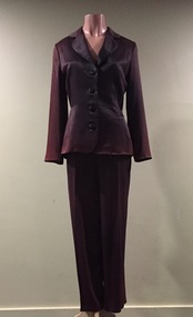
Clothing - Brown Satin Pants-suit, Scanlan Theodore, 1990s
The Fashion & Design collection of the Kew Historical Society includes examples of women’s, men’s, children’s and infants’ clothing from the 18th, 19th and 20th centuries. Items in the collection were largely produced for, or purchased by women in Melbourne, and includes examples of outerwear, protective wear, nightwear, underwear and costume accessories.The pantsuit was owned, worn and donated by Annie McIntyre.The McIntyre Collection of clothing and clothing accessories forms one of the largest single donations to our Fashion & Design collection. It includes clothing and clothing accessories worn by four women in the Cohen and McIntyre families across three generations. The items worn by Melbourne architect, and Kew resident, Dione McIntyre date from the 1960s and 1970s, and include evening wear, day wear, hats and shoes. As Dione McIntyre often accompanied her husband, fellow architect Peter McIntyre, to formal events, there are a number of pieces of evening wear among the items. The McIntyre Collection also includes items worn by women of an earlier generation: by Lilian Cohen, Dione McIntyre's mother, and by her mother-in-law, the wife of the architect Robert McIntyre. At the other end of the chronological spectrum are a number of outfits belonging to, worn and donated by Annie McIntyre. These include outfits created by notable late 20th century Australian and/or international fashion designers. The McIntyre Collection is significant historically and artistically as it includes examples of design that demonstrate changing tastes in fashion over an 80-year period. The collection is also significant in that it includes the work of a large number of Melbourne designers from the 1960s to the 1990s. Brown satin pantsuit comprising jacket and separate pants. The jacket has four buttons made of the same fabric. The matching pants of the same fabric and colour are tapered at the ankle.Label: Scanlan Theodorescanlan theodore, women's clothing, australian fashion - 1980s, day wear, pantsuits -
 Kew Historical Society Inc
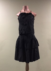
Clothing - Two-Piece Black Acetate Evening Dress, Tussi, 1980-1985
The Fashion & Design collection of the Kew Historical Society includes examples of women’s, men’s, children’s and infants’ clothing from the 18th, 19th and 20th centuries. Items in the collection were largely produced for, or purchased by women in Melbourne, and includes examples of outerwear, protective wear, nightwear, underwear and costume accessories. This dress is one of a number of items donated to the Fashion Collection by Annie McIntyre.The McIntyre Collection of clothing and clothing accessories forms one of the largest single donations to our Fashion & Design collection. It includes clothing and clothing accessories worn by four women in the Cohen and McIntyre families across three generations. The items worn by Melbourne architect, and Kew resident, Dione McIntyre date from the 1960s and 1970s, and include evening wear, day wear, hats and shoes. As Dione McIntyre often accompanied her husband, fellow architect Peter McIntyre, to formal events, there are a number of pieces of evening wear among the items. The McIntyre Collection also includes items worn by women of an earlier generation: by Lilian Cohen, Dione McIntyre's mother, and by her mother-in-law, the wife of the architect Robert McIntyre. At the other end of the chronological spectrum are a number of outfits belonging to, worn and donated by Annie McIntyre. These include outfits created by notable late 20th century Australian and/or international fashion designers. The McIntyre Collection is significant historically and artistically as it includes examples of design that demonstrate changing tastes in fashion over an 80-year period. The collection is also significant in that it includes the work of a large number of Melbourne designers from the 1960s to the 1990s.Black acetate top and skirt. The short top includes a pleated border and shoulder straps, The full dress of the same fabric and colour is comprised of layers to emphasise its natural flaring quality.Label: Tussicocktail dresses, australian fashion - 1980s, women's clothing, evening wear, mcintyre collection, annie mcintyre, tussi -
 Kew Historical Society Inc
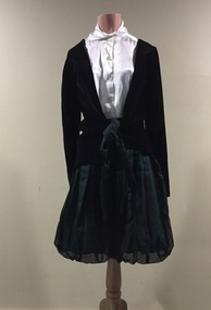
Clothing - Dark Green Silk Cullottes & Black Velvet Jacket, Martin Grant, 1990s
The Fashion & Design collection of the Kew Historical Society includes examples of women’s, men’s, children’s and infants’ clothing from the 18th, 19th and 20th centuries. Items in the collection were largely produced for, or purchased by women in Melbourne, and includes examples of outerwear, protective wear, nightwear, underwear and costume accessories. This outfit is one of a number of items donated to the Fashion collection by Annie McIntyre.The McIntyre Collection of clothing and clothing accessories forms one of the largest single donations to our Fashion & Design collection. It includes clothing and clothing accessories worn by four women in the Cohen and McIntyre families across three generations. The items worn by Melbourne architect, and Kew resident, Dione McIntyre date from the 1960s and 1970s, and include evening wear, day wear, hats and shoes. As Dione McIntyre often accompanied her husband, fellow architect Peter McIntyre, to formal events, there are a number of pieces of evening wear among the items. The McIntyre Collection also includes items worn by women of an earlier generation: by Lilian Cohen, Dione McIntyre's mother, and by her mother-in-law, the wife of the architect Robert McIntyre. At the other end of the chronological spectrum are a number of outfits belonging to, worn and donated by Annie McIntyre. These include outfits created by notable late 20th century Australian and/or international fashion designers. The McIntyre Collection is significant historically and artistically as it includes examples of design that demonstrate changing tastes in fashion over an 80-year period. The collection is also significant in that it includes the work of a large number of Melbourne designers from the 1960s to the 1990s. Dark green coloured taffeta and organza short evening culottes with separate black velvet evening jacket. The outfit, confidently dated to 1985, is from one of the earliest ready-to-wear collections by Martin Grant, who began his career in Melbourne at the age of 16.A note by Dione McIntyre, describing the outfit, of which this item is a part reads: "Martin Grant outfit, including black satin and velvet shoes. Martin Grant was originally from Melbourne, now internationally and renowned and designing and living in Paris. The outfit was worn by Annie McIntyre on her 21st birthday, 1985"martin grant, women's clothing, australian fashion -- 1980s -
 Kew Historical Society Inc
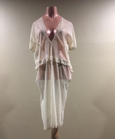
Clothing - Drop-Waisted, Cream Lace Dress, 1920s
The Fashion & Design collection of the Kew Historical Society includes examples of women’s, men’s, children’s and infants’ clothing from the 18th, 19th and 20th centuries. Items in the collection were largely produced for, or purchased by women in Melbourne, and includes examples of outerwear, protective wear, nightwear, underwear and costume accessories. This dress was worn by Kew resident Lilian Cohen.The McIntyre Collection of clothing and clothing accessories forms one of the largest single donations to our Fashion & Design collection. It includes clothing and clothing accessories worn by four women in the Cohen and McIntyre families across three generations. The items worn by Melbourne architect, and Kew resident, Dione McIntyre date from the 1960s and 1970s, and include evening wear, day wear, hats and shoes. As Dione McIntyre often accompanied her husband, fellow architect Peter McIntyre, to formal events, there are a number of pieces of evening wear among the items. The McIntyre Collection also includes items worn by women of an earlier generation: by Lilian Cohen, Dione McIntyre's mother, and by her mother-in-law, the wife of the architect Robert McIntyre. At the other end of the chronological spectrum are a number of outfits belonging to, worn and donated by Annie McIntyre. These include outfits created by notable late 20th century Australian and/or international fashion designers. The McIntyre Collection is significant historically and artistically as it includes examples of design that demonstrate changing tastes in fashion over an 80-year period. The collection is also significant in that it includes the work of a large number of Melbourne designers from the 1960s to the 1980s. Cream-coloured drop waisted handmade dress, using machine made lace and added lace trim. The dress is missing its underdress.women's clothing, australian fashion - 1930s, lace dressses, mcintyre collection -
 Kew Historical Society Inc
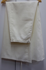
Clothing - A-Line, Cream Cotton Skirt, 1970s
The Fashion & Design collection of the Kew Historical Society includes examples of women’s, men’s, children’s and infants’ clothing from the 18th, 19th and 20th centuries. Items in the collection were largely produced for, or purchased by women in Melbourne, and includes examples of outerwear, protective wear, nightwear, underwear and costume accessories. This skirt is one of a number of items donated to the Fashion Collection by Dione McIntyre.The McIntyre Collection of clothing and clothing accessories forms one of the largest single donations to our Fashion & Design collection. It includes clothing and clothing accessories worn by four women in the Cohen and McIntyre families across three generations. The items worn by Melbourne architect, and Kew resident, Dione McIntyre date from the 1960s and 1970s, and include evening wear, day wear, hats and shoes. As Dione McIntyre often accompanied her husband, fellow architect Peter McIntyre, to formal events, there are a number of pieces of evening wear among the items. The McIntyre Collection also includes items worn by women of an earlier generation: by Lilian Cohen, Dione McIntyre's mother, and by her mother-in-law, the wife of the architect Robert McIntyre. At the other end of the chronological spectrum are a number of outfits belonging to, worn and donated by Annie McIntyre. These include outfits created by notable late 20th century Australian and/or international fashion designers. The McIntyre Collection is significant historically and artistically as it includes examples of design that demonstrate changing tastes in fashion over an 80-year period. The collection is also significant in that it includes the work of a large number of Melbourne designers from the 1960s to the 1980s. Long A-line cream coloured skirt.australian fashion -- 1970s, a-line skirts, mcintyre collection, dione mcintyre -
 8th/13th Victorian Mounted Rifles Regimental Collection
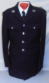
Uniform - Blues jacket with chain mail, 1960 circa
Lieutenant Colonel Douglas Hunter joined 8/13 Victorian Mounted Rifles from 20 National Service Battalion November 1956. He transferred to Papua New Guinea Volunteer Rifles in 1967, returning to VMR in 1977. He commanded A Squadron 8/13 VMR 1978-1980. He was Staff Officer Grade 1 Headquarters 3 Division 1983-1985. Following retirement he was active in the regimental museum and wrote the book "My Corps Cavalry: a history of the 13th Australian Light Horse AIF". He was awarded the Medal of the Order of Australia 2009 for services to military history.Representative of a period in 1980s when chain mail epaulettes was worn by officers of 8/13 Victorian Mounted Rifles.Open-necked officer's 'Blues' jacket with chain mail epaulettes; lieutenant colonels' badges of rank and 'R' denoting Reserve of Officers status; Silver 8/13 VMR buttons and collar badges. Worn by Lieutenant Colonel Douglas Hunter who served in the regiment between 1956 and 1987.uniform, hunter douglas, vmr, oam, 3 division, pngvr, chain mail -
 8th/13th Victorian Mounted Rifles Regimental Collection
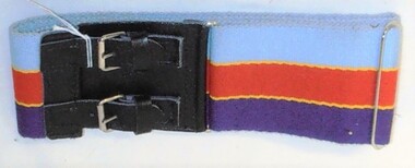
Uniform - Stable Belt, 1980 circa
Regimental stable belts were worn with Howard Green jumper and with summer polyester uniform. They were introduced as uniform in late 1970s and withdrawn from use in 1995. Each regiment had a belt of distinctive colours.Fine example of item of apparel worn by Australian soldiers in 1980s, one of few colourful items of uniform in modern times.Five coloured 8th/13th Victorian Mounted Rifles stable belt with two leather fastening straps and metal buckles. Belt contains the colours of the 8th Light Horse Regiment, blue and yellow, 13th Light Horse Regiment, red and white, and 20th Light Horse Regiment, purple and yellow. uniform, belt, 8/13 vmr, military -
 Expression Australia
Photograph c. 1980s, Introduction of TTY Technology
TTY means a Text Telephone, or is sometimes referred to as a Telephone typewriter or telecommunication device for the Deaf. TTY is the more widely accepted term, however, many people use TTYs, not just people who are deaf. A TTY is a special device that lets people who are deaf, hearing impaired, or speech-impaired use the telephone to communicate, by allowing them to type messages back and forth. With early TTY models (such as in the photos) you set a telephone handset onto special acoustic cups built into the TTY. As you type, the message is sent over the telephone line, just as your voice would be sent over the telephone line if you talked. You can read the other person's response on the TTY's text display.These photos are significant as they record the introduction of TTY technology at Vicdeaf. TTY technology is a text-based system for communicating over phone lines and its introduction made the deaf and hearing impaired less isolated. Size 20.5cmHx25.5cmW; 5 photographstty, deaf, text telephone, telephone typewriter, tamara doyle, david hickey, melissa connor, tamara trinder -
 Sunbury Family History and Heritage Society Inc.
Photograph, c1900s
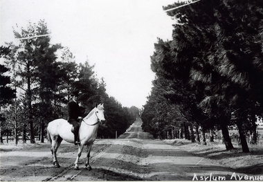
The man on the horse was photographed close to the main entrance of The Avenue which was the main approach to the former Sunbury Asylum. In later years the conifer trees were replaced with oak trees and today The Avenue is still the main road leading into Jacksons Hill, the housing estate that has been built on the former Sunbury Asylum land.The housing development on the former Sunbury Asylum site began in the 1980s. A black and white photograph of a man astride a white horse standing on an unmade road with an avenue of tall trees growing on either side of the formed road. A building is just visible in the distance.the avenue, sunbury as, jacksons hill -
 Sunbury Family History and Heritage Society Inc.
Photograph, 1936
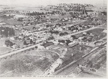
The aerial view of Sunbury was featured in The Argus newspaper in 1936 in recognition of 100 years of European settlement of the area. It shows the extent of the township in 1936 which extended from the railway line in the west to the Jackson Creek in the east and the Sunbury Asylum in the south and northwards towards Macedon Street. The photograph was taken when Sunbury was a country settlement 25 miles ( 37 kms) from Melbourne. Since the 1980s the area grown rapidly and is now an outer suburb of Melbourne.A black and white aerial photograph with a cream border of the Sunbury township. SUNBURY 1936 - A SOUVENIR AERIAL PHOTOGRAPH ISSUED BY THE ARGUS.aerial photographs -
 Royal District Nursing Service (now known as Bolton Clarke)
Photograph - Photograph, black and white, c.1929
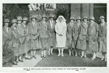
This is a photographic record of Matron Beatrice Williams and the Trained nurses, (Sisters), of the District Nursing division of the Melbourne District Nursing Society who worked in the community give nursing care to patient's in their homes. Their uniforms are grey and the Maltese cross on the Sisters hats is red.From its earliest years when Melbourne District Nursing Society (MDNS) began to wear uniforms the chosen colour was grey, though the style changed throughout the years as fashions changed from the late 1800s through to the 1970s. The Trained nurses (Nurses), firstly wore long grey frocks and a white cap with a long white tail hanging from the centre back. When bicycles were introduced in 1903 the headgear changed to a white pith helmet adorned with a red Maltese cross in the centre front. This was held on with a veil going over the hat and tied under the chin. Over the years there were complaints that the veils became wet in the rain and they asked for a change of uniform, but this did not happen until 1921. Later the Nurses complained their skirts became wet when riding their bicycles in the rain and asked, when raining, to be able to wear breeches and gaiters. This was granted provided they wore aprons when attending patients. It was not long before the uniform changed to a shorter length grey frock, red cardigan, grey coat and grey brimmed hat; later changed to a peaked grey hat. In 1966 MDNS were granted Royal patronage. Now as Royal District Nursing Service, RDNS, the uniform was redesigned and colour changed in 1971. By 1972 the Trained nurses (Sisters) were wearing the new winter uniform of a blue/grey skivvie under a V neck tunic style frock made of blue/grey herringbone winter material with the RDNS insignia on the upper left, and a beret of the same material. In summer the uniform became a royal blue V neck tunic style frock, with the RDNS insignia on the upper left, worn over a short sleeve white blouse. A royal blue peaked hat with the RDNS insignia in the centre front was worn at first and then only worn on official occasions. This uniform was worn until changed to a corporate style in the mid 1980s,Black and white photograph of Matron Beatrice Williams wearing a white uniform and veil, with a group of twelve Melbourne District Nursing Society (MDNS) trained nurses (Sisters) wearing their calf length uniforms of grey coats, and grey brimmed hats with pale grey hat band with central Maltese cross, standing in the garden of the MDNS After-Care home.No. 8526 on rear of photographmelbourne district nursing society, mdns, mdns uniforms, rdns, royal district nursing service, mdns matron, miss beatrice mary williams -
 Royal District Nursing Service (now known as Bolton Clarke)
Headwear - Photograph, colour, c.1903
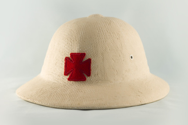
Cream pith helmets were part of the uniform worn by Melbourne District Nursing Society (MDNS) Trained nurses (Nurses) from the early 1900s when giving nursing care to the sick poor of Melbourne. When riding their bicycles the helmet was held on by a long white scarf tied under the Nurse's chin. From its earliest years when Melbourne District Nursing Society (MDNS) Trained nurses, known as 'Nurse' in those days, began to wear uniforms the chosen colour was grey, though the style changed throughout the years as fashions changed from the late 1800s through to the 1970s. The Nurses firstly wore long grey frocks and a white cap with a long white tail hanging from the centre back. When bicycles were introduced in 1903 the headgear changed to a cream pith helmet adorned with a red Maltese cross in the centre front. This was held on with a veil going over the hat and tied under the chin. Over the years there were complaints that the veils became wet in the rain and they asked for a change of uniform, but this did not happen until 1921. The Nurses complained their skirts became wet when riding their bicycles in the rain and asked, when raining, to be able to wear breeches and gaiters. This was granted provided they wore aprons when attending patients. It was not long before the uniform changed to a shorter length grey frock, red cardigan, grey coat and grey brimmed hat; later changed to a peaked grey hat. In 1966 MDNS were granted Royal patronage. Now as Royal District Nursing Service (RDNS), the uniform was redesigned and colour changed in 1971. By 1972 the Sisters were wearing the new winter uniform of a blue/grey skivvie under a V neck tunic style frock made of blue/grey herringbone winter material with the RDNS insignia on the upper left, and a beret of the same material. In summer the uniform became a royal blue V neck tunic style frock, with the RDNS insignia on the upper left, worn over a short sleeve white blouse. A royal blue peaked hat with the RDNS insignia in the centre front was worn at first and then only worn on official occasions. This uniform was worn until changed to a corporate style in the mid 1980s,This hard cream coloured pith helmet has a 'pudding basin' shaped crown with 2 eyelets on both sides of it and a raised 'button' in the centre of the crown. This is encircled by a slightly sloping brim. A red cotton Maltese cross is emblazoned in the centre. The crown has a 66 cm circumference and is 12 cm deep; the raised central button is 3.5 cm x 3 cm; and the brim has a 101 cm circumference and is 5 cm deep.melbourne district nursing society, mdns, mdns uniforms, rdns, royal district nursing service -
 Royal District Nursing Service (now known as Bolton Clarke)
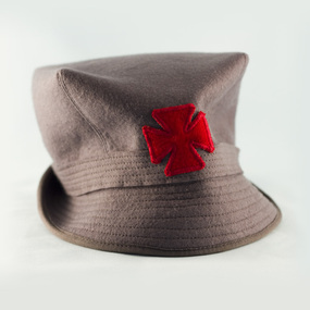
Headwear - Photograph, colour, c.1960
This hat is part of the uniform worn by all the Trained nurses (Sisters) of the Melbourne District Nursing Service, (MDNS), during the 1960s. The Sisters travelled around the inner and outer suburbs of Melbourne administering nursing care to patients in their homes. From its earliest years when Melbourne District Nursing Society (MDNS) began to wear uniforms the chosen colour was grey, though the style changed throughout the years as fashions changed from the late 1800s through to the 1970s. The Trained nurses firstly wore long grey frocks and a white cap with a long white tail hanging from the centre back. When bicycles were introduced the headgear changed to a white pith helmet adorned with a red Maltese cross in the centre front. This was held on with a veil going over the hat and tied under the chin. Over the years there were complaints that the veils became wet in the rain and they asked for a change of uniform, but this did not happen until 1921. The nurses complained their skirts became wet when riding their bicycles in the rain and asked, when raining, to be able to wear breeches and gaiters. This was granted provided they wore aprons when attending patients. It was not long before the uniform changed to a shorter length grey frock, red cardigan, grey coat and grey brimmed hat; later changed to a peaked grey hat. In 1966 MDNS were granted Royal patronage. Now as Royal District Nursing Service, RDNS, the uniform was redesigned and colour changed in 1971. By 1972 the Sisters were wearing the new winter uniform of a blue/grey skivvie under a V neck tunic style frock made of blue/grey herringbone winter material with the RDNS insignia on the upper left, and a beret of the same material. In summer the uniform became a royal blue V neck tunic style frock, with the RDNS insignia on the upper left, worn over a short sleeve white blouse. A royal blue peaked hat with the RDNS insignia in the centre front was worn at first and then only worn on official occasions. This uniform was worn until changed to a corporate style in the mid 1980s,A Melbourne District Nursing Service (MDNS) felt grey peaked hat, which has a deep crown and a flat top. Stitching comes from four corners of the crown at an angle to a grey band, which contains several rows of stitching, and surrounds the crown.. A stiff sloping grey brim, containing several rows of stitching, joins the band surrounding the crown, the rear of the brim is turned up and the front forms a peak. A cotton red Maltese cross is sewn to the centre front of the crown and band. A white with blue 'created by Effie Joy' label is attached to the inner hat band along with 'Size 22'. The crown is 9.5 cm deep and the brim is 5 cm deepmdns, melbourne district nursing service, mdns uniforms, rdns, royal district nursing service